A small portion of the 150,000 books in Larry McMurtry’s bookstore, Booked Up, in Archer City Texas. Imagine what it was like with four bookstore and 450,000 books in the small town of 1750 people.
Texas is rich in unredeemed dreams. —Larry McMurtry
Larry McMurtry wanted to save Archer City by turning it into a mecca for book lovers. He had a dream of the streets being lined with bookstores and of people coming from thousands of miles away to wander the streets, soak up the ambience and buy books. They would fill local hotels, eat at local restaurants— and spend money. The economy would boom.
“Certainly on the vast windy plain, there was plenty of nothing to be looked at.” —Larry McMurtry
It wasn’t to be. Maybe the town was too far away from any major population center— surrounded by “plenty of nothing,” maybe the Internet was to blame, maybe the town didn’t care enough. Or maybe McMurtry didn’t want to work 24/7 on the task. Writers live to write, not build cities. And writing will be his legacy. Long after he has passed on, and possibly long after Archer City has become a dim memory, people with still be reading and loving his books and watching the movies based on his books and screenplays.
The tradition I was born into was essentially nomadic, a herdsmen tradition, following animals across the earth. The bookshops are a form of ranching; instead of herding cattle, I herd books. Writing is a form of herding, too; I herd words into little paragraph-like clusters. —Larry McMurtry
McMurtry’s roots run deep in the area. He had been raised just outside Archer City on a ranch. (His grandfather’s saddle can still be seen in the local museum.) Books weren’t a part of his early years, there wasn’t one in his house, but members of his family were great story tellers. It was a skill that was passed on to the young Larry. In 1942 a cousin left behind a box of 19 books, a treasure trove that Larry loved to tatters, like other kids love stuffed animals down to their stuffing.

The saddle of Larry McMurtry’s grandfather that is now located in the Archer County Museum.
With the story telling and his cousin’s books as inspiration, McMurtry went on to become one of the best writers of our era, chronicling life in the West as few others have done. He also adapted several of his books to television and movies. Think: Lonesome Dove, The Last Picture Show, Terms of Endearment, Texasville and Brokeback Mountain. McMurtry’s efforts have earned him a Pulitzer Prize, 13 Academy Awards and 7 Emmys.

The last Picture Show was filmed in Archer City and used the Royal Theater as its model. It burned down but is now used for theater productions— and weddings, apparently.

I was bicycling way out on the Playa at Burning Man in the Black Rock Desert of Nevada last year when I came across this theater that was modeled after the theater in the Last Picture Show.
In addition to his passion for writing, McMurtry developed a passion for collecting books. Bookstores going out of business, estate sales, and even local garage sales were all an excuse to go book hunting. Starting in Washington DC, he opened a bookstore called Booked Up, to house his collection. In 1987, he moved Booked Up to Archer City. His collection would grow to 450,000 books and occupy four buildings in downtown Archer.
Archer was a town in trouble. With the cattle industry declining and oil wells drying up, the city was on the endangered species list of West Texas towns. Somewhat along the line of the 1989 movie, Field of Dreams, “if you build it they will come,” McMurtry built one of the largest bookstores in America in Archer. People came, yes, but never in the numbers necessary to change Archer’s future. In 2012, Larry packed up the books from three of his warehouses, some 300,000 books, and auctioned them off. He was in his mid-70s and neither kids nor grandkids were particularly interested in the business.
Bookstore #1 is still there, however, and still packed with 150,000 books. To all of those who reported on the demise of Booked Up, McMurtry declared “Rumors that we have moved or been sold are pernicious nonsense! We are right where we have been for so long — on Main St. in Archer City.”
I didn’t make it to Archer City on my 1989 bike trip. Booked Up had just opened and the town was 45 miles out of my way. Thousands of miles of bicycling lay ahead. I did drop by in 2005, however. Our daughter Tasha was having our first grandson, Ethan, in Tennessee and I was on my round-about way there. (Peggy had flown in for the necessary hand-holding at the time Ethan chose to drop in on the world. Grandpa was driving the van and would be a few days late. Ethan approved of my tardiness. But if he didn’t, who’s to say.)
I spent several hours in Archer City wandering around through the four warehouses of books, a book lover in book heaven. The only place I found staff was in Bookstore #1. Beyond that, an honor system existed. I eventually picked out a few books and headed over to #1 to pay.
Peggy and I also took a detour to Archer City on my recent bike route review. I wanted her to see Booked Up. In fact, we had a date. Peggy’s brother, John Dallen, and his wife, Frances, drove up from their home in Georgetown, Texas to join us. While we were spending the night at an RV campground in Wichita Falls, John and Frances stayed at Archer’s Spur Hotel, along with one other guest and an elk.

The KOA where Peggy and I stayed in Wichita Falls, Texas, had to have the most imaginative dog walk area I have ever seen. Imagine how much water a male dog would have to drink to leave his mark on all of the fire hydrants.

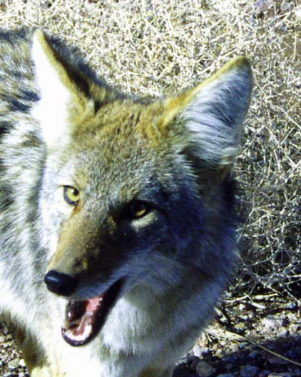
The elk at the Spur Hotel in Archer City where John and Frances stayed, appeared like he had something to say.
We met them in the morning and had a couple of hours to kill before the bookstore opened. We decided to go on a tour, pretty much having the town to ourselves. There were only four people out and about— and that included us. We admired the historic courthouse, stopped off at the Royal Theater for an obligatory photo and then checked out the lobby of the Spur Hotel where I held a spirited, but silent, conversation with the elk. The whole business took about 30 minutes.

The historic Courthouse has been restored and is quite attractive.

Peggy, John and Frances in front of the Royal Theater.
Still having an hour and a half before the bookstore opened, I suggested we visit the town’s museum. I had read about it on the Internet. It was housed in the town’s retired jailhouse and still featured a hanging gallows that had never been used but must have inspired local drunks to sober up. Unfortunately, the museum was closed. A handwritten note was taped to the door, however. It said if we wanted to visit the museum we should call Mary Ann and gave her phone number. Peggy said, “Why not,” and made the call. Mary Ann came right over. What a kick!

The Archer County Museum was originally built as a jail in 1909. The bottom floor served as a home for the sheriff and his family. The top two floors included cells and a hanging gallows. A hand written note on the door told us we were to call Mary Ann if we wanted a tour.
The museum was definitely in need of some loving attention but it was full of interesting items. Mary Ann turned out to be extremely knowledgeable, not to mention funny. At one point she picked up a large snake-skin and explained how she had found its six-foot owner coiled up in the toilet. The story, along with a photo, had been run in media around the world.

Mary Ann Levy holds up the snakeskin from the six-foot rat snake she found in the museum’s toilet. The picture also provides an idea of how crammed the museum is with items from Archer County’s history.
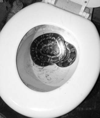
The photo of the snake that was taken by Barbara Phillips of the Archer County News and made its way around the world. I think I would be hesitant to use the toilet after that!

I want this guy to represent the many interesting things housed in the museum. My first reaction was, “What the heck!”

And then I saw a photo the museum featured.

The jail, in itself is worthy of stopping off at the museum. Here I am locked up in the drunk tank.

The women’s cell featured a throne with a view and a blue bathtub.

The upstairs gallows was finished in 1910. There was a trapdoor under the noose that was released by the lever in back. Hanging was outlawed in 1911 and the gallows was never used.

John, always up for a little gallows humor, modeled for me. He refused to put the noose over his head, however.
After we broke out of jail, it was time to visit the bookstore. 150,000 book were more than enough to keep us busy. I disappeared into the stacks and side rooms for a couple of hours— lost to the world and my fellow travelers, who tried to find me. “Where were you?”

The Booked Up sign in the window of Bookstore #1 signifies just how informal the store is.

John and Peggy peruse the history section at Booked Up. John is an avid amateur historian, particularly of the Civil War era.

I wandered around into the far corners of the store where I found a refrigerator covered in unusual refrigerator art. I wondered if McMurtry had been responsible for the decoration.

I also found this dramatic skull with its Saguaro Cactus backdrop.

And this skull as well, which I thought was appropriate for a bookstore whose owner had written so many intriguing books about the West.
Archer City has started planning a Larry McMurtry Festival in 2017, designed to celebrate McMurtry and encourage young artists. Larry and his wife, Faye, widow of author Ken Kesey, showed up for the meeting. Possibly the town has finally found a way to utilize McMurtry’s fame and his life-long commitment to the city to assure a touch of prosperity.
I’ll end this post with a final quote from Larry McMurtry that fits with my 10,000-mile bike trip and my general philosophy of life:
“If you wait, all that happens is that you get older.”
NEXT BLOG: A ping! and broken spoke lead me into more Texas adventures.