I Meet a Babe in Minnesota… The 10,000-Mile Bike Trek


This beautiful cove is found along Minnesota's scenic Highway 61 on the north coast of Lake Superior.

This beautiful cove is found along Minnesota’s scenic Highway 61 on the north coast of Lake Superior.

The Canadian Border guard glanced at my California driver’s license, smiled, and waved me through. How threatening could a guy on a bicycle be? It was a simpler time— a peaceful interval between America’s seemingly endless wars, before the onslaught of real and imagined terrorism, and before two good neighbors required passports to enter and leave.

The American Custom’s inspector was a bit more suspicious. They usually are. Maybe I was a pot-smoking hippie, an escapee to Canada from wars past. Middle-aged men were supposed to be busy working 40-hour weeks, knee-deep in kids and nose-deep in debt while supporting the American economy, not running away on six-month bicycle adventures. He had questions to ask. How long had I been in Canada, where had I traveled, what was my reason for being in the country, where had I stayed? I didn’t tell him about sleeping out along the highway or taking a bath in two cups of water. It might have been pushed him over the edge. Eventually he sent me on my way, grumpy that he hadn’t found a reason to declare me Un-American. I was just glad he didn’t make me empty my panniers. He would have discovered my very dangerous dirty socks.

I was sad to leave Canada. It had been an important part of my bicycle journey. I remembered the friendly people, the beauty of Nova Scotia, my first stumbling attempts at long forgotten French in New Brunswick, and the endless miles and wilderness of northern Quebec and Ontario. But further adventures waited. First up was a 114-mile ride along Minnesota Highway 61, a scenic road that parallels the north shore of Lake Superior from Canada to Duluth and is renowned for its beauty, a beauty that includes the lake, islands, quiet coves, crashing waterfalls, and one of the world’s most photographed lighthouses.

Overlook on Minnesota Highway 61 that provides a view of Islands in Lake Superior.

An overlook provided a view of islands in Lake Superior.

Old cabin on Minnesota's scenic Highway 61 along the north Shore of Lake Superior.

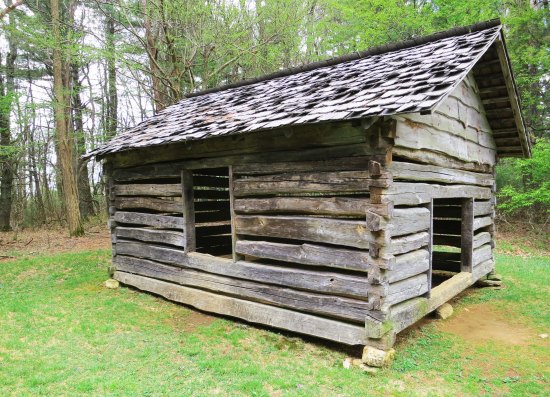
This old cabin was once someone’s beach front property on Lake Superior.

Lake Superior provided a storm-free days for me with small lapping waves, not the monsters that are known to roll across the lake in November.

Lake Superior provided storm-free days for me with small lapping waves, not the monsters that are known to roll across the lake in November.

A beach on the North Shore of Lake Superior.

Another example. The red rocks caught my eye.

The Cross River on the north shore of Lake Superior along Minnesota's scenic Highway 61.

Foaming falls on the Cross River just before it flows into Lake Superior.

The Cross River of Michigan just before it flows into Lake Superior.

The Cross River below the falls.

A view of Minnesota Highway 61, a great road for bicycling.

A view of Minnesota Highway 61, a great road for bicycling.

The photogenic Split Rock Light house poised on a ledge above a foggy Lake Superior.

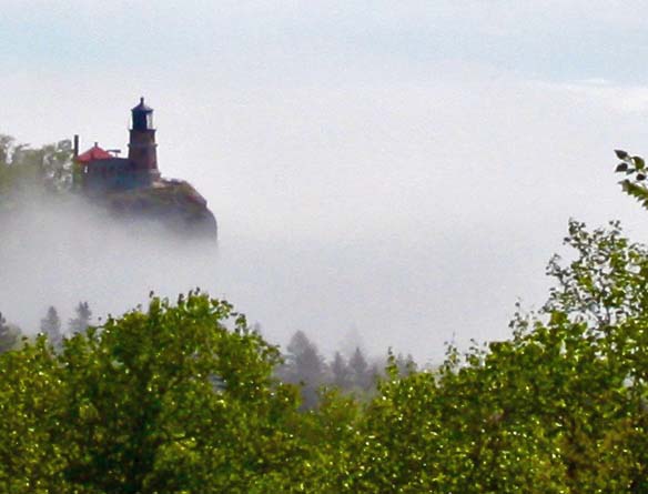
The photogenic Split Rock Lighthouse poised on a ledge above a foggy Lake Superior.

Split Rock Lighthouse on the North Shore of Lake Superior in Minnesota.

And in the distance.

Lake Superior is indeed a superior lake. It contains 10% of the world’s fresh water, which is enough to flood all of North and South America to one foot in-depth. Surface-wise, it is the largest lake on earth. The states of Vermont, Massachusetts, Rhode Island, Connecticut, and New Hampshire could easily be plopped down on top of it. Had I ridden my bike around the lake, I would have traveled some 1300 miles, an equivalent to 13% of my whole journey.

It’s so big that 40-foot high waves have been recorded rushing across its surface, sinking ships unfortunate enough to be out on the lake during major storms. Some 6,000 ships have gone down in the Great Lakes altogether, causing upward to 30,000 deaths— and the numbers may be much higher. Gordon Lightfoot memorialized one of the shipwrecks in his 1976 ballad, The Wreck of the Edmond Fitzgerald. On November 10, 1975, the ship had encountered a massive storm with 35 foot waves on Lake Superior and been sunk, taking all 29 of her crewmen to a watery grave.

Fortunately the weather was beautiful for my bike trip. November gales were still months away. I had futzed along, taking a couple of days to enjoy the beauty and give my body a break from the 80-100 mile days I had spent peddling through Quebec and Ontario. I stopped a lot.

So did Peggy and I on our revisit in June. We admired the views and took photos. The picture taking was a bit iffy, however. My Canon Power Shot 100 had died in Ontario. “Use my camera,” Peggy had urged. But her Canon EOS Rebel was sick as well. It kept giving us an Error-99 message. We looked it up on the Internet. The problem was referred to as “the dreaded Error-99 message.” Apparently the camera gave it to any issue its software couldn’t diagnose. I babied the camera along, changing its battery, cleaning its terminals, and saying nice things to it, hoping it would last until we got it to Duluth. “We’ll get you fixed, sweetheart,” I promised, and she kept snapping pictures. (It was not to be.)

The camera made it (just barely) to Duluth. The city is actually a seaport for ocean-going ships that make the 2300-mile journey to and from the Atlantic Ocean via the Great Lakes Waterway and the St. Lawrence Seaway. It has had its ups downs, historically speaking, from boom to bust, but now it seems quite healthy. We passed some lovely old buildings including a snazzy high school in our search for a camera shop. I had found an Internet recommendation for one on the outskirts.

Central High School in Duluth, Minnesota.

I found it hard to believe that this beautiful structure was built originally as a high school in Duluth. They certainly didn’t build high schools like this in California. I’m thinking Harry Potter and Hogwarts!

The owner of the camera shop, a really nice guy who was being driven out of business by the same Internet that recommend his store, looked at our camera and said, “Uh-oh. You have the dreaded Error-99 message.” We laughed. What else was there to do? He took the camera apart, did what he could, put it back together, and snapped a shot out his window. Error-99 popped up on the screen.

I bought a new Canon G7X for the road. Peggy’s new camera is waiting for Christmas.

US Route 2 took me out of Duluth all the way to Grand Forks on the border of North Dakota. Cycling was relatively easy; the weather sunny. The highlights of my ride included throwing a rock across the Mississippi River and meeting a babe— a big blue babe about 15 feet tall with four legs and a tail. A sculpture of the legendary lumberjack, Paul Bunion, and his giant Blue Ox, Babe, is located in the town of Bemidji, Minnesota. Babe was so big, folklore tells us, that Paul used her to straighten out crooked logging roads by hooking her up to one end of the road and having her pull. When she had to scratch an itch on a tree, the tree would fall down and beg for mercy. Once she was pulling a water cart that sprang a leak. It created the Mississippi River! Statues of Paul and Babe are actually found in several locations in the US. (Peggy and I drove by one last week in the Redwoods of Northern California.)

A view of the Mississippi River as it looks in Northern Minnesota.

A view of the Mississippi River as it looks in Northern Minnesota.

A side view of the Visalia-Natchez Bridge across the Mississippi River with a barge passing under it.

The Visalia-Natchez Bridge I had used to cross the Mississippi River earlier in my trip when I had left Louisiana and entered Mississippi. Maybe Paul Bunion could throw a rock across it.

Another view of the Mississippi in Minnesota.

Another view of the Mississippi in Minnesota. Even I could throw a rock across this one.

Paul Bunion and his Blue Ox Babe in Minnesota. Peggy is standing next to Pau's leg to prove a perspective on size.

Paul Bunion and his Blue Ox Babe in Bemidji, Minnesota prove that Canada isn’t alone in creating large, humorous statues. Peggy is the tiny person standing next to Paul’s leg to provide a perspective on size.

Minnesota Highway 2 leads me into North Dakota, more stormy weather, and the sneakiest dog in 10,000 miles.

Next Blog: Minnesota Highway 2 leads me into North Dakota, more stormy weather, and the sneakiest dog in 10,000 miles.


The Cannonball Ghost… and Other Scary Halloween Tales: Part II

On November 15, 1777, the British lobbed 1000 cannonballs per hour into the tiny Fort Mifflin in an all out effort to resupply British troops in Philadelphia. Four of my ancestors fought in the battle and two were killed. Did they become ghosts?

On November 15, 1777, the British Navy lobbed 1000 cannonballs per hour into the tiny Fort Mifflin in an all out effort to resupply British troops in Philadelphia. Four of my ancestors fought in the battle and two were killed. Did they become ghosts? The forts ammunition magazine can be seen on the other side of the Canadian Geese.

Fort Mifflin, located next to the Philadelphia Airport, is well-known for its ghosts. For a time during the Revolutionary War, it was all that stood between the mighty British Navy and George Washington’s ragtag army of Revolutionaries. The few brave men stationed there had fought a heroic battle and succeeded in holding off the British for several weeks. Many of the defenders were killed, including two of my Great, Great, Great, Great Grandfather’s brothers.

Peggy and I visited the Fort several years ago on Halloween and decided it would be fun to go on a special Halloween Night tour. “Maybe the Mekemson ghosts will be lurking,” I had told Peggy.

Our guide had gathered us up. His lantern was immediately blown out. “It’s only the wind,” he explained. “I don’t believe in ghosts. I don’t hunt them and they don’t hunt me.” His disclaimer came with a ‘but.’ He worked at the Fort, and occasionally ‘things’ happened. Doors closed and latched on their own. A woman screamed like she was being murdered. The police were called but couldn’t find anyone— or thing.

He related story after story as we made our way through the candle lit buildings of the fort. Other staff, volunteers and visitors had also experienced strange phenomena. More than one visitor had left on the run and even the guide had packed up and gone home on one occasion. He was spending the night in a second-floor room when he heard footsteps coming up the stairs. He opened the door and no one was there. Next he heard voices coming from the room next to him. He checked. No one was there either. He packed up and left, quickly.

We arrived at the Fort’s ammunition magazine, a bush covered hill that resembled an ancient burial mound. A bright hurricane torch outlined the dim opening. We entered and walked down a narrow, dimly lit corridor that opened out to a large, arched bunker. A single candle created dancing shadows on the far wall. Reputedly, a man dressed in Revolutionary Soldier garb had once greeted guests in the dark room and vividly described the horrendous battle that had taken place on November 15, 1777. Afterwards, the tourists had stopped at the park headquarters to report on how much they had enjoyed the presentation. The Fort had no such guide.

The entrance to the ghostly ammunition magazine taken during the day.

The entrance to the ghostly ammunition magazine taken during the day. The hurricane lantern is on the right.

“I’ve never felt anything in here,” the tour leader related. “It’s dead space,” he quipped. I stared hard into the corner where the soldier had supposedly stood, trying to create something out of nothing. But there were only the dancing shadows. Peggy tried to take a photo but the camera froze and refused to work. As she struggled with it, the last of our tour group disappeared down the narrow corridor, leaving us alone with the flickering candle.

We hurried after the group. There was no one outside the magazine, only the glowing torch and the dark night. “I saw them heading down a side corridor,” Peggy said. With more than a little reluctance, we dutifully trooped back inside. Peggy’s corridor was a bricked in wall. I was starting to feel spooked.

“Maybe we should go back to the bunker,” she suggested.

“Maybe not” I had replied and headed for the entrance, with Peggy close behind. Just as we arrived, the hurricane torch, which was designed to withstand high winds, was blown out by a slight puff of ice-cold air, leaving us with nothing but dark.

The hairs on the back of my head stood at attention. Was my ancient Uncle Andrew trying to communicate with us? He had been cut in half by a cannon ball after saving the Fort’s flag. Maybe he was still seeking his other half. Peggy and I decided it was time to vacate the premises.

Once you've become thoroughly "spooked," every dark corridor, such as this one at Fort Mifflin becomes a potential hiding place for a ghost.

Once you’ve become thoroughly “spooked,” every dark corridor, such as this one at Fort Mifflin becomes a potential hiding place for a ghost.

Fortunately, we found our group several buildings away and stuck like super glue to them the rest of the tour.

Tomorrow’s Halloween Blog: A Lonely Grave… Peggy and I are looking for the grave of an ancestor, shot down as a Scottish Presbyterian Martyr, when we see what almost had to be a ghost.

Walking on Dead People… and other Scary Halloween Tales: Part I

Incense Cedar tree in Diamond Springs California graveyard

Looking spooky, this tree dominates the graveyard that is located next to the house where I grew up. My brother and I had a tree fort on the lower limbs. We would hold races with the neighborhood kids to see who could climb the fastest from the fort to the 70-foot top and back. Being the youngest, I tended to slip more often.


A brief break from biking…

Halloween is here, and with elections just around the corner, things are very scary in the US. But I am not going to go there, not today. It’s too scary. I’d rather talk about ghosts.

It’s that time of the year when I break out family ghost stories. And since I only have a few, I am forced to return to previous posts. I have to dig up a few graves, sort through old bones, and hope that the ghosts I stir up haven’t haunted you in the recent past.

Anyway, I found three blogs that came from 2012 or earlier. I will post one today, one tomorrow, and one on Halloween.

I. Walking on Dead People

Let me start by noting that I was raised next door to a graveyard. It was out the backdoor and across a narrow dirt alley. We lived with its ghostly white reminders of our mortality day and night. Ancient tombstones with fading epitaphs whispered of those who had come to seek their fortune in California’s Gold Rush and stayed for eternity.

We lived on Highway 49 in Diamond Springs, California. Our house is to the right. The town's last remaining gold rush era building can be seen beyond the house.

We lived on Highway 49 in Diamond Springs, California. Our house is to the right, behind the walnut trees. The town’s last remaining gold rush era building can be seen beyond the house.

The fancier graves were surrounded by wrought iron fences like this one. We would swing on their gates, which would give off a satisfying Graveyard squeak. You can see our house beyond the fence.

The fancier graves were surrounded by wrought iron fences like this one. We would swing on their gates, which would give off an eerie Graveyard squeak. You can see the top of our house beyond the fence.

The top of this tombstone was covered with lichens that spoke of its gold rush era age.

The top of this tombstone is covered with lichens that speak of its gold rush era age.

Time had given the graveyard residents a sense of permanence and even peace. But not all of the graves were old. Occasionally a fresh body was buried on the opposite side of the cemetery. I stayed far away; the newly dead were dangerous.

At some time in the past, Heavenly Trees from China had been planted to shade the aging bones. They behaved like weeds. Chop them down and they sprang back up, twice as thick. Since clearing the trees provided Diamond Springs Boy Scout Troop 95 with a community project every few years, they retaliated by forming a visually impenetrable mass of green in summer and an army of sticks in winter. Trailing Myrtle, a cover plant with Jurassic aspirations, hid the ground in deep, leafy foliage.

Looking far too civilized, the graveyard is now well-kept. Heavenly Trees grow on the left here, however, waiting for the day when the graveyard is once again forgotten.

Looking far too civilized, the graveyard is now well-kept. Heavenly Trees growing on the left here, however, wait for the day when the graveyard is forgotten and they can once again play jungle.

Trailing Myrtle like this covered the ground and hid many of the graves.

Trailing Myrtle, like this now growing on the alley, covered the ground and hid many of the graves.

Once again found, a number of tombstones were on the ground, covered my the myrtle.

Once again found, a number of tombstones were on the ground, covered by the myrtle. This young man was born 100 years before I was born.

During the day, it took little imagination to change this lush growth into a jungle playground populated with ferocious tigers, bone crushing boas and half-starved cannibals. Night was different; the Graveyard became a place of mystery and danger. Dead people abandoned their underground chambers and slithered up through the ground.

Since I slept outside in our backyard during the summer, I was constantly hassled by these ghostly specters— especially when I was younger. I’d carefully place my bed where I couldn’t see any tombstones and I recruited the family pets for protection by allowing them to sleep on the bed. Between two dogs and three cats on a narrow cot, there was barely room for me. Once I even had a litter of kittens born on the bed while I was sleeping. I woke up with wet, wiggly feet. But the ghosts stayed away. If we chose to go into the graveyard at night, however, it was a different story…

There is nothing scary about this tomb, right. Now, picture it after dark peaking out from jungle like growth when you are six years old and sleeping outside.

This tombstone was visible from our back yard. There is nothing scary about it, right? Now, picture it as a six-year-old would see it on a moon-lit night, peeking out from the jungle-like growth. It moved about, I swear!

A local test of boyhood bravery was to visit the graveyard after dark and walk over myrtle-hidden graves, taunting the inhabitants. Slight depressions announced where they lived. It was best to avoid tripping. My older brother Marshall persuaded me to accompany him there on a moonless night when I was five. I entered with foreboding: fearing the dark, fearing the tombstones and fearing the ghosts. Half way through I heard a muzzled sound. Someone, or thing, was stalking us.

“Hey Marsh, what was that?” I whispered urgently.

“Your imagination, Curt,” was the disdainful reply.

Crunch! Something was behind a tombstone, digging and biting down on what sounded like a bone. It was not my imagination. Marshall heard it too. We went crashing out of the Graveyard with the creature of the night in swift pursuit, wagging his tail.

“I knew it was the dog all of the time,” Marsh claimed. Yeah, sure you did.

It was behind this tombstone with its secret hiding place where Tickle, the family Cocker Spaniel, had found something to dig up.

It was behind this tombstone with its secret hiding place that Tickle, the family Cocker Spaniel, had found something to dig up. Was it lost treasure or an old bone he had buried?

Tomorrow’s Halloween Tale: Peggy and I visit a Revolutionary War site on Halloween night where my ancestor cousin was cut in half by a British cannon ball. Did he really try to contact us?


The Journey Home: Only 5000-Miles left! The Ten Thousand Mile Bike Trek

The road goes ever on. At least it seemed like it on my 10,000-mile bike journey around North America. As I left Nova Scotia and started my journey west, I knew that there would be mountain ranges in my future.

The road goes ever on. At least it seemed like it on my 10,000-mile bike journey around North America. As I started my journey west, I knew that there would be mountain ranges in my future— several of them. This is the Rockies.


“It’s a dangerous business, Frodo, going out your door. You step onto the road, and if you don’t keep your feet, there’s no knowing where you might be swept off to.” J.R.R. Tolkien

I had left my home in California without a clue of what it meant to bicycle 10,000 miles. Like Frodo, I had no idea where I might be “swept off to.” There was even a chance when I reached the East Coast, I might decide to head for Europe and bicycle around the world. Why not? My personal commitments were limited and my job was a maybe. Other people would eagerly step in if I didn’t return.

By the time I reached Nova Scotia, I had gone about as far as I could go east in North America, however, and had enough adventures to last a lifetime— or at least a year.

I had bicycled through rainstorms and hailstorms and snowstorms. I had been up and over three mountain ranges. I had crossed through deserts, swamps, farmlands and forests. I’d been on remote, lonely roads and on highways clogged with traffic. I’d had close encounters with 18-wheelers, cars, dogs, and a coiled rattlesnake. I had met a lot of good folks, and a few not so good. And I had toughened up. I could now bicycle 100-miles in a day with much more ease than I had bicycled 30 miles on my first day out of Diamond Springs.

So I had decided it was okay to head home. Besides, I still had 5,000 miles to bicycle! More adventures waited.

From Nova Scotia, my plan was to bicycle across New Brunswick and into Quebec. (Would my high school French suffice?) I would bike up and over the Gaspe Peninsula, cross the St. Lawrence Seaway by ferry, and then head up into remote northern Quebec before cutting south across Ontario. At Thunder Bay on Lake Superior, I would return to the US and bicycle across Minnesota. I would then bike through North Dakota, Montana, Idaho, and Nevada before finally crossing the Sierra Nevada Mountains again, having gone full circle.

Here are some photos and a map to introduce my homeward journey.

I had been working my way east and north for close to four months. I now had two months of traveling west and south to return home.

I had been working my way east and north for close to four months. I now had a little over two months for traveling west and south to return home if I wanted to renew my contract of running long distance backpacking and bicycle treks. My days of lollygagging were over.

This is the route I followed through the US and Canada. I began and ended my trip in Northern California.

This is the map I originally posted to show my bike trek route around North America. At this point in revisiting my 1989 journey, I am at my farthest point east, ready to head west.

I could depend upon the weather continuing to keep my journey interesting.

One thing I knew for sure about the second half of my trip, I could depend upon the weather to keep my journey interesting…

There would be numerous towns to pass through that promised I would meet interesting people and enjoy unique architecture.

And the people. Whether it would be in the communities I visited, the people I met…

And unique art ranging from murals to this desert sculpture.

Or in the unique art they created.

And history...

I would also continue to be fascinated by the history, as represented by this old barn…

This sculpture of a mountain man...

A mountain man statue…

Or the way people live their mark.

And this hill where high school classes had painted their graduation years for over a century.

And other in distance vistas.

I also knew that the next 5,000 miles would bring unending, beautiful scenery— whether it would be in distant vistas such as this snow-covered mountain range…

Or this desert scene in Nevada.

Or this desert scene…

I had seen much beautiful country in my first 5,000 miles. Much more was to come.

Or in closer views such as this forest of birch,

Some would be up close...

These seashells in New Brunswick…

And in these limbs.

A desert shrub…

Nevada boulders

These boulders in Nevada…

And rivers...

And numerous rivers…

Idaho river

Idaho River

Montana stream

Snake River, Idaho

Road shot

The road would pull me on through all of it, eager to see what was over the next hill, and never tiring of what I found.

NEXT BLOG: I will finish my trip through Nova Scotia and include a detour Peggy and I made to Prince Edward Island.


From Winchester, Virginia to Halifax, Nova Scotia… The 10,000-Mile Bike Trek

After three months of bicycling, I left the US and entered Canada. This is a photo of the Consulate Building in Yarmouth, Nova Scotia.

After three months of bicycling, I left the US and entered Canada. This is a photo of the Consulate Building in Yarmouth, Nova Scotia.

In my last post, I had arrived in Winchester, Virginia on my 1989 bike trek and decided I needed to make up for some lost time and give myself a break from bicycling by taking the Greyhound bus to Bangor, Maine.

I was lucky to find the Greyhound bus depot, a motel, and a bike shop all within a few blocks of each other in Winchester. The bicycle shop gave me a bike box, which I hauled back to my motel room. I recruited a trashcan newspaper to cover the floor. Motels have little tolerance for bicycle grease (understandably), and I had a bike to dismantle. Handlebars, pedals, seat, and front wheel had to come off.

While spreading the newspaper, a headline caught my attention. Zsa Zsa Gabor had been arrested for slapping a Beverly Hills motorcycle policeman who had stopped the 66-year-old in her $215,000 Rolls Royce. Apparently Jack, as in Jack Daniels, had been involved in the altercation.

I’ve traveled by Greyhound several times in my life, starting as a child. There was a local bus we had used a few times that connected Diamond Springs and Placerville (three miles away). The bus driver’s name was Pat, which I remember because I named a stray dog after him. The dog had been wandering our neighborhood for weeks, catching an occasional jack rabbit or ground squirrel for food. My mother had watched the stray grow thinner and thinner until one day she stopped the family’s well-used car, opened the door, and invited it home for a meal. Since the dog was part greyhound, I promptly named her after the bus driver. Pat was happy with the name, eternally grateful for her food bowl, and became my faithful companion for several years. I am not sure how the bus driver felt about his namesake.

I wish I had taken more notes about my bus trip from Virginia to Maine. Traveling by Greyhound is always an experience. But I was so happy for the break from peddling, I just sat back and watched the scenery fly by. Going uphill faster than five miles per hour seemed almost unreal. I do remember that I had a layover in Washington DC that I used to visit the National Art Gallery. I was lost for several hours among the Van Gogh’s, Picasso’s, Rembrandts, and Dali’s.

I also remember I had a four-hour layover in New York City from 1:00 a.m. to 5:00. Being in any Greyhound station in the middle of the night is memorable. Multiply that by 10 for downtown NYC. I watched in awe as homeless people, hookers, beggars, and, quite possibly, vampires, zombies, and an alien or two claimed the station as their own. I was careful to mind my own business and kept my gear within easy reach. Other than distributing ‘spare change,’ and passing on an offer from a scantily dressed lady, I was left alone to wonder about the nature of my fellow denizens of the night.

Morning found me on my way to Boston, Massachusetts through Connecticut and then through New Hampshire into Maine. Having stayed awake at the NYC bus station, I was in desperate need of a nap, but New England was far too interesting for sleep. Strong coffee helped keep my eyes open for most of the journey. Arriving in Bangor, Maine I quickly found a motel and slept for 12 hours.

New England has great beauty.

New England has great scenery as demonstrated by this gently flowing stream…

And this dark beauty.

And this dark beauty.

Houses, especially older ones, tend to be big. Imagine yourself cooped up with a large family over winter.

Houses, especially older ones, tend to be big. Imagine yourself cooped up with a large family over winter. These three structures are all connected and are part of the house.

I wonder how many Christmas Cards over the years have featured a New England church like this one surrounded by snow and a small village.

I wonder how many Christmas cards over the years have featured a New England church like this one surrounded by snow and a small village.

A small pond in Bangor provided me with a reflection shot.

A pond in Bangor provided me with a reflection shot.

I had been in Maine once before. In 1976, my first wife, Jo Ann, and I had taken a year off to travel through the South Pacific and Asia. But first we had bought a VW Camper Van and made a leisurely trip across the US with our Basset Hound, Socrates. My friend Morris had volunteered to keep the dog while we traveled overseas. After dropping Soc off with Morris and his wife Marianna, we had hung around for another week and backpacked on the Appalachian Trail in Maine. I wanted to make sure that Morris and the dog were compatible.

It had been a long week for us with 24/7 rain, muddy trails, black flies, mosquitoes and no-see-ums. It was much easier for Morris and Socrates. They had bonded instantly and apparently had a grand time. Upon our return from the backwoods, we had received a couple of wags from Soc before he returned to drooling over whatever treats Morris was offering him. Food had always been an important factor in determining the dog’s loyalty.

I had thought about Socrates when I woke up from my 12-hours of sleep in Bangor and put my bike back together. Shortly after breakfast, I was on Highway 1 making my way toward Bar Harbor, Maine and Acadia National Park. It was a short trip, hardly longer than 50 miles. I was there by early afternoon and settled into a campground.

You might wonder why I would feature this Dunkin' Donuts sign I found outside of Bangor on the way to Bar Harbor. The reason is I never passed up a donut shop on my trip!

You might wonder why I would feature this Dunkin’ Donuts sign I found outside of Bangor on the way to Bar Harbor. The reason is I never passed up a donut shop on my trip! I’d look like an elephant if I did that now.

I promised myself I would do absolutely nothing for a week while I waited for my friends Jean Snuggs and Lyndell Wilken who were going to bicycle around Nova Scotia with me. It almost worked— and would have except for two things. One, I had a responsibility to catch mosquitos with my hands and squash them before they landed on me and started to suck my blood. Given how numerous and hungry they were, I pursued this responsibility with passion.

Second, I discovered David Eddings’ series of five fantasy books on the Belgariad in a small bookshop a few miles from my camp. I’d picked up the first one and become hooked. I found I could hold a book in my left hand while squashing mosquitos with my right. Needless to say, the days passed quickly and soon Jean and Lyndell had arrived at my campsite, smiling and eager to catch the ferry to Yarmouth, Nova Scotia, which we did. Since our goal was to bike the northern part of the Province, we took a bus into Halifax. The Canadian part of my bicycling adventure was about to begin.

Ferry terminal entry in Yarmouth Nova Scotia.

The entry to the ferry terminal in Yarmouth.

Crab fishing is important off of Nova Scotia and there must be thousands of crab traps such as this in Yarmouth.

Crab fishing is important off of Nova Scotia and there must be thousands of crab traps such as this in Yarmouth.

Peggy makes herself at home on furniture made out of crab traps next to a restaurant where we had dined on crab.

Peggy makes herself at home on furniture made out of crab traps next to a restaurant where we had dined on crab.

Salvation Army building in Yarmouth, Nova Scotia.

Yarmouth has done a good job of renovating historical buildings. This may be the fanciest Salvation Army Thrift Store I have ever seen. It is next to the Consulate building I featured at the beginning of the post.

More fun buildings in Yarmouth.

More fun and colorful buildings in Yarmouth.

This mural featured a number of inhabitants in the town.

This mural featured a number of inhabitants in the town.

While my bike journey took us southeast toward Halifax, Peggy and I also explored the west coast of Nova Scotia along what is known as the Evangeline Trail. A number of impressive catholic Churches reflect the French Acadian history of the area.

While my bike journey took us southeast toward Halifax, Peggy and I also explored the west coast of Nova Scotia along what is known as the Evangeline Trail. A number of impressive Catholic Churches reflect the French Acadian history of the area. The road, which travels along the Bay of Fundy, noted for its extreme tides, is well worth a side trip.

We found this mysterious 'road less traveled' along the Evangeline Trail.

We found this mysterious ‘road less traveled’ along the Evangeline Trail.

And this impressive Catkin.

And this impressive Catkin.

Back on track, following the coast south out of Yarmouth, we came on this unusual Anglican Church, which represented Nova Scotia's English heritage for me.

Back on track, following the coast south out of Yarmouth, we came on this unusual Anglican Church, which represented Nova Scotia’s English heritage for me.

A small lake near Halifax provided a sunset shot...

A small lake near Halifax provided a sunset shot…

A small lake just west of Halifax provided this reflection shot...

…And a late evening view, which is an appropriate place to end today’s post.

NEXT BLOG: Bicycling north from Halifax toward Cape Breton Island.


A Foggy Day in Shenandoah National Park… The 10,000-Mile Bike Trek

Regulations on the Blue Ridge Parkway and Skyline Drive understandably recommend that bicyclists not travel on foggy days. The fog does present some good photo ops, however.

Regulations on the Blue Ridge Parkway and Skyline Drive understandably recommend that bicyclists not travel on foggy days. The fog does present some good photo ops, however.


“Oh Shenandoah, I long to see you/Away you rolling River/Oh Shenandoah, I long to see you/Away, I’m bound away/Cross the wide Missouri.”

There are songs that you hear as a child that bury themselves deep in your brain and are forever being replayed. Oh Shenandoah was one such song for me. It had a yearning that even my 9-year-old soul understood. I longed to see the Shenandoah River, and return to it— even though I had never been there.

It isn’t surprising then that Shenandoah became my song of the day as I wrapped up my bike tour of the Blue Ridge Parkway and entered Skyline Drive and the Shenandoah National Park. I often sang on my bike. It helped wile away the hours. But this time I sang with the same longing I had felt as a fourth grader.

Peggy and I woke up to a foggy morning on our last day of retracing my bike route along the Blue Ridge Parkway. I was glad I wasn't riding my bike.

Visibility can be a real issue when the fog sets in for bicyclists as well as motorists.

A pine tree stands out in the fog along the Blue Ridge Parkway.

But fog has a way of shrouding everything in mystery.

Skyline Drive provides the same beauty, lack of commercial traffic and slow speed limit as found on the Blue Ridge Parkway, without the severe ups and downs.

Skyline Drive starts where the Blue Ridge Parkway ends when you are riding south to north. It provides the same beauty, lack of commercial traffic, and slow speed limit as found on the Parkway, without as many ups and downs.

Dogwood in fog along Skyline Drive in Virginia.

Distant vistas disappear in the fog. The traveller is left with views closer to the road…

A tree of dogwood blooming along the Skyline Drive in Virginia.

That bring their own beauty…

Trees along the Skyline Drive in Shenandoah National Park.

With a different perspective.

Pine needles provided an interesting pattern in the fog.

The grey backdrop made these pine needles stand out.

Not sure what these flowers were, but I found their green hue appealing.

Fog or not, I always like close-ups. The yellow-green hue of these flowers, and their abundance, caught my attention.

Tree lichens caught the attention of my camera.

Lichens are always worth a closer look..

Riding along the Skyline wasn’t enough for me, however. Oh Shenandoah was about the river and I had to see it! I reached US Highway 33 and made a snap decision. Instead of following Skyline Drive the rest of the way to Front Royal, Virginia, I would turn left and drop down into the Shenandoah Valley where I could sing to the river. And that is what I did. In Elkton, I picked up US 340 and followed it along the south fork of the Shenandoah River to Front Royal.

A cow and her calf welcomed me to the Shenandoah Valley.

Peggy and I followed the same route in our van as we retraced my route. A cow and her calf welcomed us to the Shenandoah Valley.

Welcome sign to Shenandoah.

As did this sign.

As this pasture land demonstrates.

Spring was bursting out all over!

This old fireplace was all that remained of an earlier Shenandoah Valley home.

This old fireplace was all that remained of an earlier Shenandoah Valley home. It isn’t unusual to find fireplaces standing alone, the one thing that wouldn’t burn when pioneers lost their homes to fires. This one would have gone with a large home.

And yes, I did find the Shenandoah River with its mountain backdrop.

And yes, I did find the Shenandoah River with its mountain backdrop.

From Front Royal I biked on to Winchester where a billboard announced I was entering Patsy Cline’s hometown. I had another decision to make, this one more dramatic than my quick decision to check out the Shenandoah River. I had been bicycling for three months and I needed a break. A friend was supposed to meet me in two weeks in Maine and join me in bicycling through Nova Scotia. I could make it, just barely, maybe. But I would have to push hard through urban areas with urban traffic. Finally, I had developed a sore on my inner thigh in Mississippi and a sore on your inner thigh when you are bicycling is not a good thing. It would not go away.

Old Town in Winchester Virginia has bee turned into a pleasant and attractive auto-free zone. Patsy Cline would recognize the buildings.

Old Town in Winchester, Virginia has been turned into a pleasant and attractive auto-free zone. I think that Patsy Cline would like it..

So I decided to become good friends with the Dog. I would take the Greyhound from Winchester up though Washington DC, New York City, Boston and New England to Bangor, Maine. It would drop the total distance of my trip to around 10,000 miles, but I could live with that— and I would have a two-week break.

Next Blog: I make it to Maine and begin my exploration of Nova Scotia.

Back When Having a Baby Cost Six Bucks… The 10,000-Mile Bike Trek

Mary Mill on the Blue Ridge Parkway in Virginia.

Mabry Mill is one of the most photographed sites on the Blue Ridge Parkway. (Photo by Peggy Mekemson.)

I continued my roller coaster ride along the Blue Ridge Parkway as I crossed into Virginia. The highlands weren’t as high but the lowlands were lower so my overall impression of the Parkway didn’t change. I was growing more used to the ups and downs, however. I won’t say I didn’t notice them— the 6000-foot elevation change involved in dropping into and climbing out of the James River guaranteed that, but the beauty of the ride, combined with the interesting history, was enough to divert my mind away from the work my legs, lungs and heart were doing.

View of Blue Ridge Mountains and meadow along the Blue Ridge Parkway in Virginia.

The beauty of the Parkway helped me forget I spent much of my time bicycling up mountains.

Dramatic clouds along the Parkway added to the scenery.

Dramatic clouds along the Parkway added to the scenery.

Tree silhouette backed up by clouds on the Blue Ridge Parkway in Virginia.

This tree silhouette also caught my attention.

Bridge on the the Blue Ridge Parkway in Virginia.

Man made structures such as this double arched bridge also add to the beauty.

Besides, the only person that I had to complain to about the difficulty of the climbs was myself, and he’s a stickler for pointing out that I am responsible for 99.9% of the difficulties I get into. You would think he would be more sympathetic, maybe even lie a little. But noooo, he has to be disturbingly honest.

Plus, there was Orlena Puckett. She put things into perspective. There is a sign next to her sister’s cabin on the Parkway. Orlena was born in 1837 and spent the first 50 years of her life trying to have children. She actually had 24, but they all died, most in stillbirth. Given everything I’ve ever heard about the pain involved in having a baby, I would have sworn off sex after the first three.

The Plackets cabin on the Blue Ridge Parkway in Virginia.

The Puckett’s cabin.

Orlena spent the second 50 years of her life as a midwife, helping other women have children. She is said to have delivered some 1,000, the last when she was 102. The tools of her trade were soap, water, and a nip of whiskey. When times were good, she charged six dollars; when they were bad, one— or a few chickens. Legend has it she would drive nails through her shoes in winter so she could travel over icy trails to help women who needed her services. Imagine that with today’s medical care system, even a nip of whiskey would cost $100!

This photo of Orlena, looking 102 and holding the last child she helped be born, is next to her sister's cabin.

This photo of Orlena, looking 102 and holding the last child she helped deliver, is on display next to her sister’s cabin.

Groundhog Hill is located a couple of miles away from the cabin. I am assuming there were a lot of them there. They were also called whistle pigs, which I get. I’ve often encountered their marmot cousins in western mountain meadows. These large, fat squirrels whistle at you in irritation when you disturb their afternoon naps in late August. They’ve chowed down all summer so they can sleep all winter. Folklore tells us that groundhogs appear on February 2 to predict how long winter will last. (This custom originated with European badgers, who, as far as I know, would consider it great luck to find a tasty groundhog out and about on February 2, regardless of whether you could see its shadow or not.)

Today, Groundhog Hill is topped off by a fort-like looking structure that the forest service once used for spotting fires. The area also features the various types of chestnut split-rail fences the pioneers used to keep their cattle from wandering off and being eaten by bears.

The Groundhog Mountain fire lookout tower on the Blue Ridge Parkway in Virginia.

The Groundhog Mountain fire lookout tower with a dramatic display of clouds.

Groundhog Mountain on the Blue Ridge Parkway in Virginia.

Peggy caught this photo with clouds, a dogwood tree, and two of the fence types. (Photo by Peggy Mekemson.)

Pioneer fence on display at Groundhog Mountain on the Blue Ridge Parkway in Virginia.

We saw this type of fence on the Natchez Trace as well. Easily constructed, it requires no fence posts.

Fence at Groundhog Mountain on the Blue Ridge Parkway in Virginia.

The fourth type of pioneer fence on display at Groundhog Mountain.

Further along, I came to Mabry Mill (featured at the top of the post), said to be the most photographed site on the Parkway. It is quite striking in its pond setting. The water wheel driven mill was built by Ed Mabry in the early 1900s and served as both a gristmill and a sawmill. During the summer months now, park volunteers offer demonstrations on a number of pioneer crafts practiced in the area. It’s a busy place. Several hundred thousand people stop by to visit each year.

The 13 mile ride downhill to the James River was quite a thrill; I practiced not using my brakes. When I passed an auto, I decided it was time to slow down. At the bottom, I stopped to admire the river. At 649 feet, it is the lowest spot on the Parkway. Further east, Virginia slaves once toiled on farms along the river producing what was considered some of the finest tobacco of the time. I first heard about it when I was backpacking in the Wind River Mountains of Wyoming and had stopped at a Fur Rendezvous site where early traders bought beaver pelts from mountain men.

The James River tobacco had been an important trade item. The mountain men smoked it on lonely winter nights when they were back in their trapping cabins. Lower quality tobaccos were mixed with whiskey in cooking kettles and consumed on the spot, out of the kettles. Drunken debauchery is a fairly good description of the results. Early journals described a rabid wolf wandering through camp and biting people at will. Another image that stuck in my mind was a group of men using a dead man as a poker table. Now it will probably be stuck in your mind as well. (Grin)

Reflection shot of the James River as see from the Blue Ridge Parkway bridge.

The James River looking calm on a cloudy day.

Otter Lake on the Blue Ridge Parkway in Virginia.

Pretty little Otter Lake is just a couple of miles beyond the James River going north on the Parkway.

Spillway to Otter Lake along the Blue Ridge Parkway in Virginia.

The spillway for Otter Lake is also quite picturesque.

Otter lake spillway along the Blue Ridge Parkway in Virginia.

Another perspective of the spillway.

Otter Creek along the Blue Ridge Parkway in Virginia.

Otter Creek below the spillway.

Further up the Parkway, the historic remnants of the Irish Creek narrow gauge railway caught my interest. Logging had once been the dominant industry of the region until most of the virgin forests had been cut down. Over 100-million board feet of lumber had passed over the Irish Creek line alone. My dad had worked as the electrician for a lumber company that had a narrow gauge railroad when I was a child. I remember watching the long trains of logs come rolling into town. I’d stand by the tracks with my friends and wave at the engineers. On a good day, they would throw candy out the window to us.

Railroad bridge for the Irish Creek railroad found along the Blue Ridge Parkway in Virginia.

Bridge on the Irish Creek narrow gauge railroad. (Photo by Peggy Mekemson.)

Irish Creek Railroad next to the Blue Ridge Parkway in Virginia.

The Irish Creek Railroad.

Small creek along the Irish Creek Railroad next the the Blue Ridge Parkway in Virginia.

A final view of the small creek.

Next Blog: We’ll say goodbye to the Blue Ridge Parkway and head into Shenandoah National Park on the Skyline Drive.

Things that Go Bump in the Night… The 10,000-Mile Bike Trek

I decided that my title today called for this 'ghost tree' I found along the Parkway. Imagine it at night with a full moon behind it and a black cat sitting on the lower branch.

I decided that my title today called for this ‘ghost tree’ I found along the Parkway. Imagine the tree at night with a full moon behind it and a black cat sitting on the lower branch.


From ghoulies and ghosties / And long-legged beasties / And things that go bump in the night, / Good Lord, deliver us! —An old Scottish Prayer

Having spent a considerable amount of time out in the woods at night, including a fair amount by myself, I’ve had my share of nighttime encounters. To say they can be disconcerting is understatement at its best. Even a cow walking through your camp can send your heart racing when you wake up from a deep sleep.

I’ve written about some of my encounters before. Why not? They make great blog material. For example, there was the time I found myself nervously loading a 357-magnum pistol because I had heard a loud bang outside my tent. A doctor friend had insisted I carry his gun in backcountry Alaska. I was damned lucky I didn’t shoot myself in the foot. I was amused (or was that embarrassed) to discover it was only a beaver that had slapped its tail against the water. He had discovered me in his territory and was protesting.

And then there was the time I woke up with a bear standing on me, his snout inches away from mine. I screamed. So much for being manly. Truth is, the smallest twig cracking out in the dark night can lead brave souls to become hyper-alert, or maybe just hyper.

Camping out in the woods away from established campgrounds on my bike trip added another level of concern, being faced with the most dangerous animal of all— the two-legged type. I’ll take a bear anytime. Breaking twigs in the night become even more menacing. As I mentioned before, I was always careful to select a place where I was hidden from the road, or any other human observation, as far as that goes.

The Blue Ridge Parkway has a policy on not camping outside of designated campgrounds. For the most part this isn’t a problem, but I had decided to have my bike tuned in Asheville and didn’t get out of the town until late in the afternoon. (Having learned my lesson on dark tunnels, I had also bought a new bike light.) A considerable hill outside of Asheville had slowed me down, and the sun had started to slip behind a mountain.

Being tired and a bit grumpy, I decided a couple of hours of bicycling were sufficient. So I pulled off the road and went looking for a flat spot in the steep terrain, one that wouldn’t have me rolling down hill all night. Eventually I found a place that was only slightly askew. There was just enough room for my tent. Blue, my bike, had to be satisfied with leaning against a tree. Tossing and turning because a rock insisted on poking me in the back, it took a while to fall asleep.

Having crested one long climb with an even longer one ahead, I decided to camp out in the woods. The steep terrain made finding a flat spot difficult.

Having crested one long climb with an even longer one ahead, I decided to camp out in the woods. Finding a flat spot other than the road was the challenge.

I woke up to someone/thing stamping outside my tent. Make that several things. I am sure you can see where this might be a bit alarming. I lay there wondering whether I should jump out of my tent or pretend that no one was home. Sometimes ignored problems go away. Sometimes they don’t. I had decided on the latter course when the problem started hissing. Stamping is one thing; hissing is another. Had the Appalachian ghosts of Tom Dooley and his mistresses come to haunt me?

This sign along the Parkway describes the origin of the Kingston Trio Song, "Hang Down Your Head Tom Dooley."

This sign along the Parkway describes the origin of the Kingston Trio Song, “Hang Down Your Head Tom Dooley.” Their song was the PG version, however. Tom was living with a much older guy who had a younger wife. With mutual consent from all parties, Tom started sleeping with the wife. When a cousin of the wife showed up, he added her to the mix, often at the same time. Another cousin appeared on the scene and Tom once more sacrificed himself for the good of all. She brought syphilis into the mix, however. Eventually, one of the cousins killed another one with Tom’s help. Being a gentleman, Tom confessed to the murder and she went free. Tom was hung. At least I think that’s how it went. I became distracted with the appearance of the first cousin. Undoubtedly, the event left some ghosts hanging around.

This was the point where I started wishing my backpacking flashlight had a ton more of candle power. I unzipped my tent and pointed the dim light up the hill where several large things went crashing off into the brush. There’s a point here. It is always better to have large things crashing away from you instead of toward you, even more so on a dark night. Anyway, I recognized the thump, thump, thump as they disappeared. A herd of several deer had discovered my hiding place, and like the beaver, been surprised and irritated. I had simply never heard deer do their stamping and hissing routine before. (I have since.)

I went back to sleep, woke up refreshed (sort of), and resumed my journey. Today’s blog photos along the Blue Ridge Parkway will take you from Asheville to Little Glade Mill Pond, a distance of approximately 170 miles. Enjoy.

The ultra modern Park Headquarters in Asheville includes all of the latest environmental friendly designs, including plants growing on the roof.

The ultra modern Park Headquarters in Asheville includes all of the latest environmental friendly designs, including plants growing on the roof.

Bike sculpture in Blue Ridge Park Headquarters, Asheville, North Carolina.

I enjoyed the bike sculpture at the headquarters.

My first stop the next day was at the Craggy Garden's Visitor's Center. It's high location provided a great scenic view of the Black Mountains. The fence was a plus.

My first stop the next day was at the Craggy Garden’s Visitor’s Center. Its high location provided a scenic view of the Black Mountains. The fence was a plus.When I bicycled through the area in June of 1989, the area was covered with blooming Rhododendrons. Peggy and I were too early for the display on our redrive of the route this spring.

Dandelions had no problem with spring. Peggy and I found them happily blooming away throughout our trip.

Dandelions had no problems with spring. They were happily blooming away throughout our trip.

Peggy insisted on buying me a neckerchief at the Visitor's Center, which featured biking the Parkway.

Peggy insisted on buying me a neckerchief at the Visitor’s Center. It featured biking the Parkway. Like the bushy look? I was honoring my bike trek where I had three haircuts in six months.

One of numerous tunnels along the Parkway. I found the stone work quite beautiful. Sone masons from Europe were brought in during the 1930s to help.

One of numerous tunnels along the Parkway. I found the stone work quite appealing. Stone masons from Europe were brought in during the 1930s to help.

This is the twin to the tree I featured at the beginning of the blog.

This is the twin to the tree I featured at the beginning of the blog. It was actually standing next to the other tree.

Dogwood is another plant that enjoys spring and was blooming in profusion all the way along the Parkway.

Dogwood is another plant that enjoys spring and was blooming in profusion all the way along the Parkway.

A close up of the dogwood.

A close up of the dogwood complete with beetle.

Dogwood on Blue Ridge Parkway with butterfly.

And a  butterfly.

Jesse Brown's cabin on the Blue Ridge Parkway.

Peggy provides perspective on Jesse Brown’s pioneer cabin.

Cool Spring's Batist Church on the Blue Ridge Parkway.

The Cool Spring’s Baptist Church was next door to Jesse Brown’s cabin. Usually, services were held outdoors. There wasn’t much difference.

And the cool spring.

And the cool spring. The wooden channel carries water into the spring house.

I doubt the early pioneers would have seen this Scottish cow in the mountains.

I doubt the early pioneers would have seen this Scottish bull in the mountains.

Apple tree on the Blue Ridge Parkway.

Apple trees, on the other hand, were quite common. Hard cider was a pioneer staple.

Farm on Blue Ridge Parkway.

Farm lands add as much to the beauty to the Parkway as forests and mountains.

Little Glade Mill Pond on the Blue Ridge Highway.

Little Glade Mill Pond provides a great lunch stop. While Peggy whipped up sandwiches, I hiked around the pond.

Reflection shot on Little Glade Mill Pond on the Blue Ridge Parkway.

Naturally, I had to focus on the reflection shots. Our van is off to the right. Lunch is being prepared! Breakfast is my responsibility.

I'll complete today's post with this final shot of Little Glade Mill Pond. Next Blog: We'll continue out journey along the beautiful Blue Ridge Parkway.

I’ll complete today’s post with this final shot of Little Glade Mill Pond. Next Blog: We’ll continue out journey along the beautiful Blue Ridge Parkway.


48,722 Feet of Climbing on the Blue Ridge Parkway… The 10,000-Mile Bike Trek

Every turn in the road on the Blue Ridge Parkway brings gorgeous views. Some are in distant vistas but many are up close and personal, like these two trees.

Every turn in the road on the Blue Ridge Parkway brings gorgeous views into sight. Some are in distant vistas but many are up close and personal, like these two trees.

There are two primary directions on the Blue Ridge Parkway: up and down. It’s a good thing I had gotten used to this idea while crossing the Cumberland Plateau and the Smokies because as soon as I passed the entrance sign to the Parkway, I started climbing. I quickly got used to the idea that I would be granny-gear-crawling my way up a mountain for 3-4 hours followed by a glorious 30-minute downhill run, followed by another 3-4 hours of climbing. If it wasn’t always like that, it certainly felt like it.

I took this graphic from the book by Elizabeth and Charlie Skinner featured below.

I took this graph from the book by Elizabeth and Charlie Skinner featured below. It represents about half of my first day of cycling the Parkway, starting at the Southern Terminus on the right. I thought it did a good job of summarizing my perspective on the climb.

The elevation change reflected by these ups and downs is impressive. In one week I would climb 48,722 feet and drop a similar amount, having an elevation gain and loss of over 97,000 feet! (I was amused by the Parkway’s specific claim of elevation gain right down to 22 feet. It definitely represents a biker or hiker’s perspective. Those 22 feet are important.)

It could have been worse.  Remember, in my last post, I mentioned that the Appalachians were much higher in their youth. Think 40,000 feet tall (12,192 Meters), 10,000 feet higher than Mt. Everest. The air would have been a bit thin up on top for cycling but can you imagine the downhill run! Wheeeeeeeeeeeee!

Other than the ups and downs, or maybe because of them (grin), the Blue Ridge Parkway is one of the premier destinations for bicyclists in the US. Like the Natchez Trace, there is great beauty and no commercial traffic. An added plus for the Blue Ridge is that the speed limit for vehicles is even lower than the Trace, 45 MPH (72.4 K) as compared to 55 MPH (88.5 K).

The number of T-shirts, scarves, patches, bumper strips and other memorabilia you can buy that feature bicycling on the Parkway speaks to its popularity today. There are also detailed brochures, maps and books to help you plan your trip, not to mention the Internet. It wasn’t always so. In 1989, the National Park Service gave me a mimeographed sheet. I didn’t see another bicycle tourist until I was close to the end of my 469-mile trip in Virginia.

The mimeographed sheet on bicycling the Blue Ridge Highway that the National Park Service handed out to me in 1989

The mimeographed sheet on bicycling the Blue Ridge Highway that the National Park Service handed out to me in 1989.

This information packed book by Elizabeth and Charlie Skinner is the type of information you can find today on cycling the Parkway.

This information packed book by Elizabeth and Charlie Skinner is the type of information you can find today on cycling the Parkway.

The final segment of the Parkway was finished in 1987, only two years earlier than my trip. Its inception dates back to the 1930s, however, when a number of people including Franklin Roosevelt and Senator Harry F. Byrd of Virginia decided that a parkway connecting Shenandoah National Park in Virginia with the Great Smoky Mountain National Park in North Carolina was a good idea. (Byrd, BTW, served in the US Senate from 1933 to 1965. His son succeeded him in his seat and held the position until 1982, giving the Byrds 50 continuous years in the Senate.)

My next four posts will cover my journey over the Blue Ridge Highway and be more in the nature of photographic essays. Photos will be from the trip Peggy and I took this spring. Today, I am covering the section between Cherokee and Ashville, North Carolina. Next Blog: A creature comes to visit me in the night.

When biking the Blue Ridge Parkway, you can start in the north, in the south, or at several points along the way. Wherever, you will be greeted by this sign.

When biking the Blue Ridge Parkway, you can start in the north, in the south, or at several points along the way. Wherever, you will be greeted by this sign.

The Blue Ridge Mountains provide numerous opportunities to pull off the road and admire the scenery. Plot was an early pioneer who became famous for breeding bear hunting dogs. Once, according to legend, his dogs cornered a bear in a small cave. Lott went in after the bear with his knife. He won the encounter but the bear clawed him extensively. It was the last time Lott went after a bear with his knife.

The Blue Ridge Mountains provide numerous opportunities to pull off the road and admire the scenery. Plott was an early pioneer who became famous for breeding bear hunting dogs. Once, according to legend, his dogs cornered a bear in a small cave. Lott went in after the bear with his knife. He won the encounter but learned that chasing after bears with a knife is not a good idea.

On the higer parts of the Parkway, flowers were just starting to come out.

On the higher parts of the Parkway, flowers were just starting to bloom.

This photo reflects how the Blue Ridge Mountains obtained their name.

I like this photo because it reflects for me how blue ridge after blue ridge after blue ridge gave the Blue Ridge Mountains their name.

A tunnel of trees along the Blue Ridge Parkway leafing out in early spring green.

A tunnel of trees along the Blue Ridge Parkway leafing out in early spring green. Dogwood is blooming along the left side.

Some of the canyons along the Parkway were filled with blooming dogwood.

Some of the canyons along the Parkway were filled with blooming dogwood.

And highway tunnels. There are 26 along the Blue Ridge Parkway ranging in length from 150 feet to 1434 feet.

Twin highway tunnels. There are 26 tunnels along the Blue Ridge Parkway ranging in length from 150 feet to 1434 feet. Bicycling through them can be a bit scary, especially the longer tunnels. Going through the 1434 feet Pine Mountain Tunnel, my light chose to die, leaving me in the pitch dark. I immediately climbed off my bike, blindly found the right side of the tunnel, and walked the bike until I could see again. As you can see, there is no shoulder. Fortunately no cars came along.

The lights from our van lit up the tunnel. Imagine your perspective from a bicycle. This was one time when I was ever so glad to see the light at the end of the tunnel.

The lights from our van lit up the tunnel. Imagine your perspective from a bicycle. Pushing my bike with no lights at all, I was ever so glad to see the light at the end of the tunnel.

I climbed to the highest elevation along the Parkway on my first day out. I celebrated by thinking 'well, that's behind me.'

I climbed to the highest elevation along the Parkway on my first day out. I celebrated by thinking ‘well, that’s behind me.’

More fun going down than up!

More fun going down than up!

They call this outcrop the Devils Courthouse but I was hardput to see much that was devilish about it. Maybe on a foggy day...

They call this outcrop the Devils Courthouse but I was hard put to see much that was devilish about it. Maybe on a foggy day…

Looking Glass Rock was once a giant pluton of molten volcano rock located far under the surface. Early morning light reflects off of the rock, giving it the name.

Looking Glass Rock on the right was once a giant pluton of molten volcano rock located far under the surface. Light reflects off of the rock, giving it the name. This time, the sun chose to light up the trees in the foreground instead.

I'll conclude today's section of the Blue Ridge Parkway with this impressive road cut.

I’ll conclude today’s section of the Blue Ridge Parkway with this impressive road cut.


Bicycling across Great Smoky Mountains National Park… The 10,000-Mile Bike Trek

Great Smoky Mountains National Park waterfall in North Carolina.

In addition to its tree covered mountains, the Great Smoky Mountains National Park is noted for its beautiful waterfalls. Peggy and I found this little beauty next to the road on the east side of the Park.


HAPPY 100th BIRTHDAY TO AMERICA’S NATIONAL PARKS

I can’t imagine a future without wild places for our children, grandchildren and future generations to love and explore. Preserving our wilderness areas and the diversity of life on earth are two of the most important responsibilities we have as humans.

A few years ago, Peggy and I took time off to visit America’s National Parks from Alaska to Florida. It was an incredible trip. The beauty and variety of landscapes, plants and animals found in these parks are a gift of incalculable value. As are all the wild places set aside by other countries.

Given that this week is America’s 100th Anniversary of its National Park system, it seems appropriate that I am writing today about my bike ride through (make that up and over) Great Smoky National Park. (And yes, smoky is how it is spelled.) With over nine million visitors this past year, it is America’s most visited park.

First, of course, I had to get there. In the last post about my bike tour of North America, I was in Dayton, Tennessee checking out the courthouse where the Scopes’ trial took place. I left there continuing to follow Route 30 east as it made its steep, winding way up and over ridges of the Cumberland Plateau. In Athens, Tennessee, I picked up an even smaller road, Route 39, that carried me over another ridge into the small community of Englewood.

Mural depicting the historic town of Englewood in eastern Tennessee.

This mural of historic Englewood is prominently featured on the side of a building entering town.

From here, it was time to make my way north over the relatively flat Highway 411 to Maryville. Bucolic countryside, Mennonite farms, a humorous Spit and Whittle Club, and the Little Tennessee River provided pleasant distractions from the work of bicycling. As I left Maryville on Highway 321 going toward Pigeon Ford, the countryside shifted dramatically, providing scenic views of the Smokies. The road from Pigeon Ford to Gatlinburg, Highway 441, was all about separating tourists from their dollars. I’ve rarely seen such a concentration of “tourist attractions.” Today, there are eight different Ripley’s venues alone— “believe it or not!”

This Mennonite farmer was apparently out enjoying his/her farm.

This Mennonite farmer was apparently out enjoying his/her farm since I didn’t see any work going on.

Spit and Whittle Clubs, sometimes know as Liar's Clubs, can be found throughout the US. In general, their members are story tellers who focus on 'tall tales.' I expect that this is one of their most unusual club houses!

Spit and Whittle Clubs, sometimes know as Liar’s Clubs, can be found throughout the US. In general, their members are story tellers who focus on ‘tall tales.’ I expect that this is one of their most unusual club houses!

Little Tennessee River flowing through eastern Tennessee.

Highway 411 took me across the Little Tennessee River, which didn’t seem so little to me.

The Great Smoky Mountains can be seen in the distance as you leave Maryville, Tennessee on Highway 312.

The Great Smoky Mountains can be seen in the distance as you leave Maryville, Tennessee on Highway 321.

I spent the night in Gatlinburg, not because I wanted to sample the attractions, but because I wanted to develop the proper mental attitude I would need for climbing 4000 feet in the morning to Newfound Gap at 5046 feet (1538 meters). Two beers and a steak just about did it.

The Smokies, as they are often called, received their name from a blue haze early pioneers found hovering over the mountains. It wasn’t actually caused by smoke, however, it was caused by plant respiration (breathing, so to speak). The park is part of the Appalachian Mountains, an ancient range going back some 250-300 million years. (Some rocks in the area date back over a billion years.) Compare that with the Rocky Mountains at 80-85 million years and the Sierra Nevada Mountains, a mere baby at 40 million. Once, the Smokies reached for the sky like their younger western cousins; now they are old and worn down. This doesn’t make them less steep; ask any hiker or biker who wanders through them. Nor does it make them any less beautiful.

The 17-mile trip up to the Gap was, as I expected, a workout. People shouted encouragement from their cars on some of the steeper parts. I grunted in return. At one stop a little kid looked at me wide-eyed. “Are you really bicycling to the top?” “Sure,” I replied. “It’s fun. Maybe you will do it some day.” “Maybe not,” he responded. I passed the Appalachian Trail and thought of the hikers making their way north on a journey far different from mine but similar in its challenge. And I entered North Carolina, leaving Tennessee behind. After a leisurely lunch on top, it was time to zoom down the mountain, a thrill I had earned. Following are some photos that I took when Peggy and I redrove the route though the Great Smoky Mountain National Park this spring.

View of Great Smokey Mountains National Park in Tennessee.

Peggy and I drove across the Smokies a month earlier than  when I biked across them in 1989. A number of trees had yet to leaf out.

Tree in Great Smoky Mountains National Park in early spring.

By June this tree would be dressed in green. I am not sure who the round nest on the right belongs to. Or if it is even a nest.

I liked this canyon view.

I liked this canyon view.

This stream kept me company as I biked up the mountain.

This stream kept me company as I biked up the mountain. At one point I had stopped and dangled my toes in its refreshing water.

Because the road over the mountain is so steep and filled with traffic, the National Park recommends that people not bicycle on it.

Because the road over the mountain is so steep and filled with traffic, the park recommends that people not bicycle on it. Naturally, I caught a section of the road that was car free and had a decent shoulder.

Waterfall in Great Smoky Mountain National Park in North Carolina.

This small waterfall was part of the same stream I placed at the top of the post.

I flew past the turn off that marks the southern beginning of the Blue Ridge Highway and into Cherokee, headquarters for the Eastern Band of the Cherokee Nation. I remember two things about my 1989 stop in Cherokee. One was that the town seemed economically depressed. The second was a bear in a cage. I felt sorry for it. The Smokies are known for having the largest concentration of black bears in the East. The caged bear would have been much happier running around in the woods with them.

The town seems much healthier now, largely thanks to the Harrah’s-Cherokee Hotel and Casino. It draws several million visitors (and their money) into Cherokee annually. As for the bear, I didn’t see it. Instead, brightly painted bear sculptures were found throughout the community representing, for the most part, Cherokee themes. A large, carved wooden sculpture of a Cherokee stands in front of the community’s administrative center. Three tears are streaming down his face— a memorial to the Trail of Tears where the Cherokee were forced off their homeland and marched to Oklahoma so white settlers could take their property.

Wood sculpture of a crying Cherokee representing the Trail of Tears in Cherokee, North Carolina.

The wood sculpture of a crying Cherokee.

Bear sculpture located in Cherokee, North Carolina.

This bear featured a scenic painting with an elk and an eagle or hawk.

I found this scene on another bear, representing the region in historic times

I found this scene on another bear, representing the region in earlier times.

Bear sculpture painted to resemble eagle in Cherokee, North Carolina.

Another rendition of a bald eagle. I liked how the artist turned the nose of the bear into the beak of the eagle. An eagle shaman dances on the rear hindquarters.

Bear sculpture in Cherokee, North Carolina

This bear was decorated with symbols you might expect to find on Native American rock art.

Bear sculpture in Cherokee, North Carolina smoking pie and dressed like an artist.

And, for my final photo today, a little humor.

NEXT BLOG: I ride back up the road from Cherokee to the Blue Ridge Highway entrance and begin my journey north toward Maine and Nova Scotia.