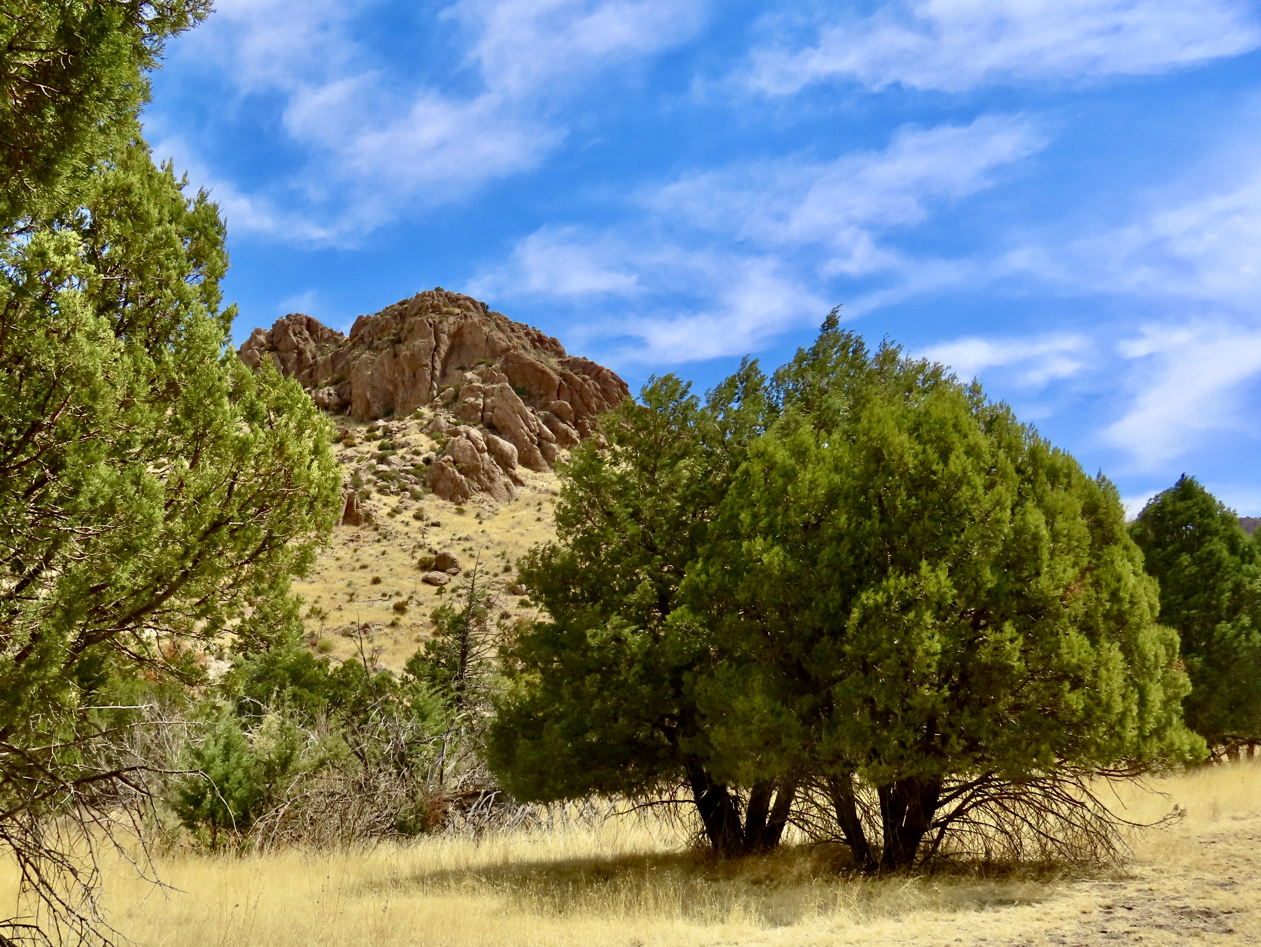
Peggy and I were immediately struck by the combination of golden grass, green trees and impressive rocks set off by the blue skies when we arrived at Chiricahua National Monument two weeks ago. There was little indication, however, of the fantasy-land of rock sculptures we were about to enter.
The rock formations got their start when a massive volcanic erupted 26.9 million years ago and buried the area under a combination of hot ash and pumice. Extreme heat then welded the ash and pumice into the rock known as tuff. As the tuff cooled, it contracted, creating cracks and joints. Water seeping into the cracks and then freezing, aided by wind and gravity, caused erosion, eventually creating the thousands of rock columns that Chiricahua National Monument is famous for.
The monument is located in southeast Arizona’s Chiricahua Mountains near the community of Willcox. Curious about the name, I googled it and was entertained by AI. First, it informed me that the Chiricahua Mountains were named after the Chiricahua Apaches who lived in the area. Ok. I then asked asked where did the Chiricahua Apaches get their name. They were named after the Chiricahua Mountains, AI stated. Hmmm. I tried again and was told that the name comes from an Opata word, “Chiwi Kawi” that translates to Turkey Mountain. Now you know. Or do you?
The Apaches were tough. Their Great War chiefs Geronimo and Cochise bordered on legendary and held out longer than most other Indian tribes of the West against the onslaught of Eastern settlers, miners, and cattlemen eager to take away their lands. The military was sent out to solve the problem by forcing them onto reservations. It was not an easy task. First they had to catch the Chiricahua who combined guerrilla warfare with an ability to disappear into the rugged landscape that seemed almost magical.
Today, Peggy and I are continuing our series on national parks, monuments, and wilderness areas with an emphasis on their unique beauty, geology, flora, fauna and history that makes them so important to us today— and even more so in the future as populations continue to expand. As Aldo Leopold said: “The richest values of wilderness lie not in the days of Daniel Boone, nor even in the present, but rather in the future.” A future that is now under threat.
National monuments are particularly vulnerable today as the Trump Administration explores downsizing several of them to open up new lands for drilling oil and mining minerals
As with each of our previous posts in this series, we will present 25 photos that focus on the beauty and unique characteristics of the park, monument, or wilderness we are blogging about. All photos have been taken by either Peggy or me unless otherwise noted.
Welcome to Chiricahua National Monument.
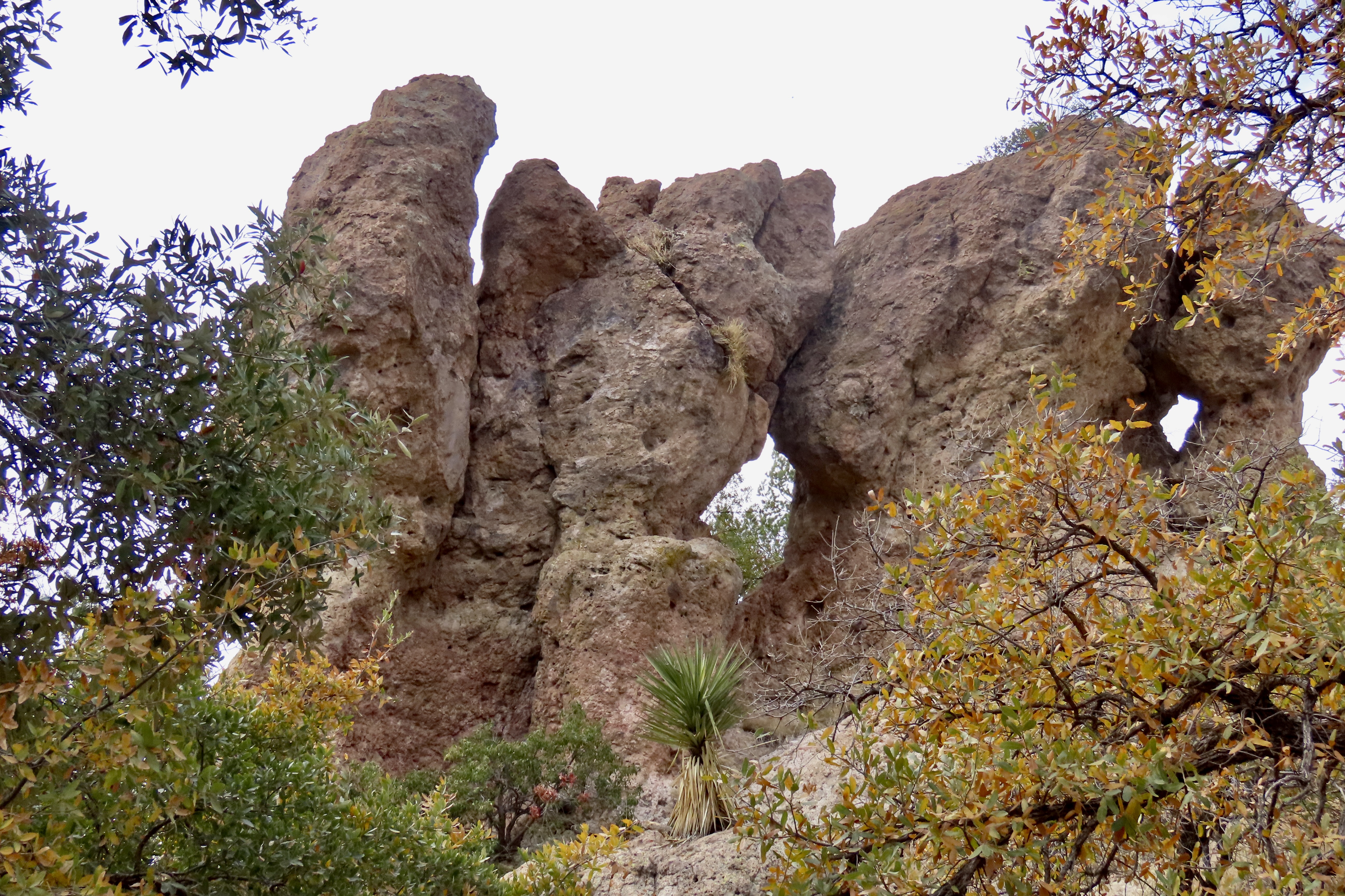
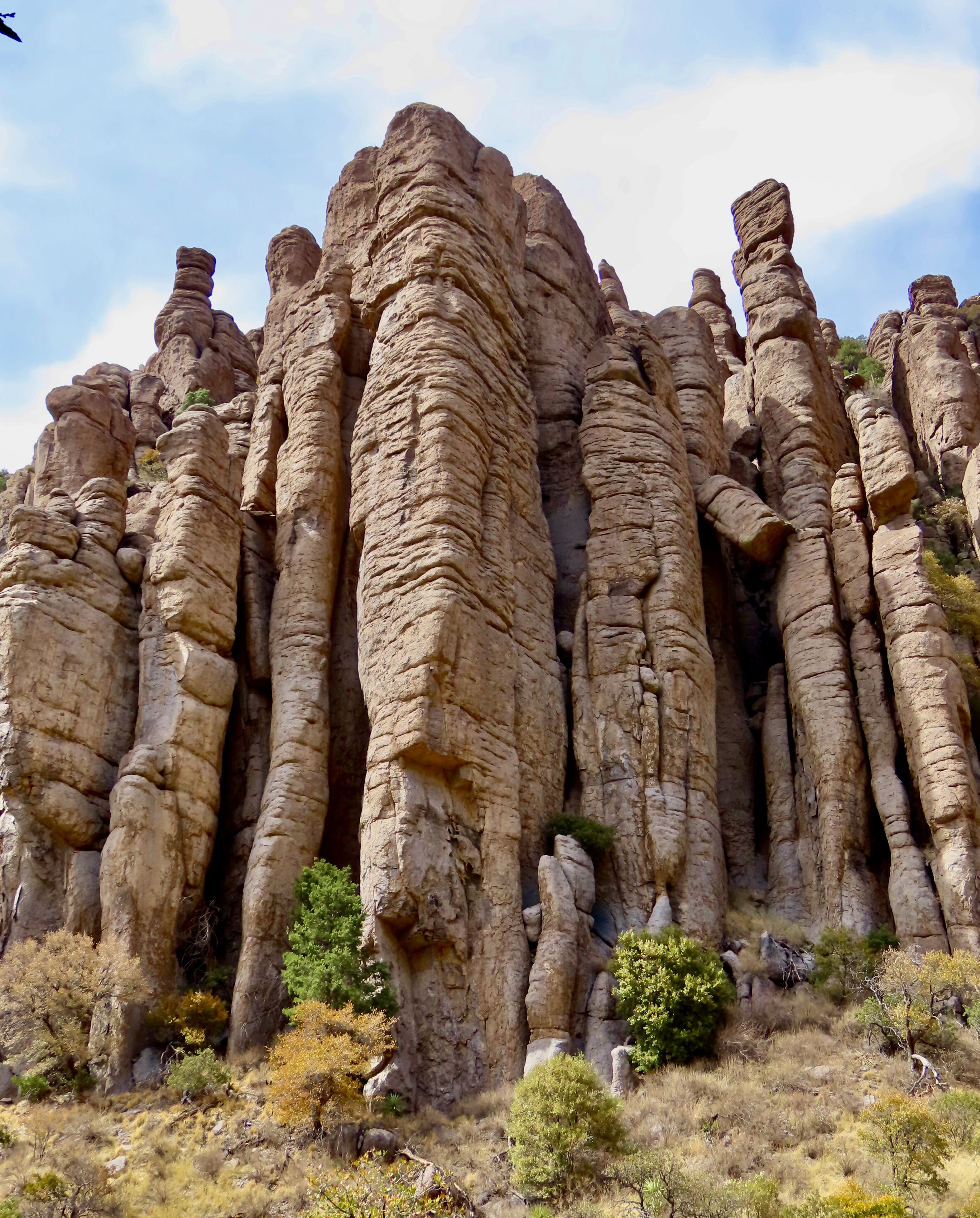
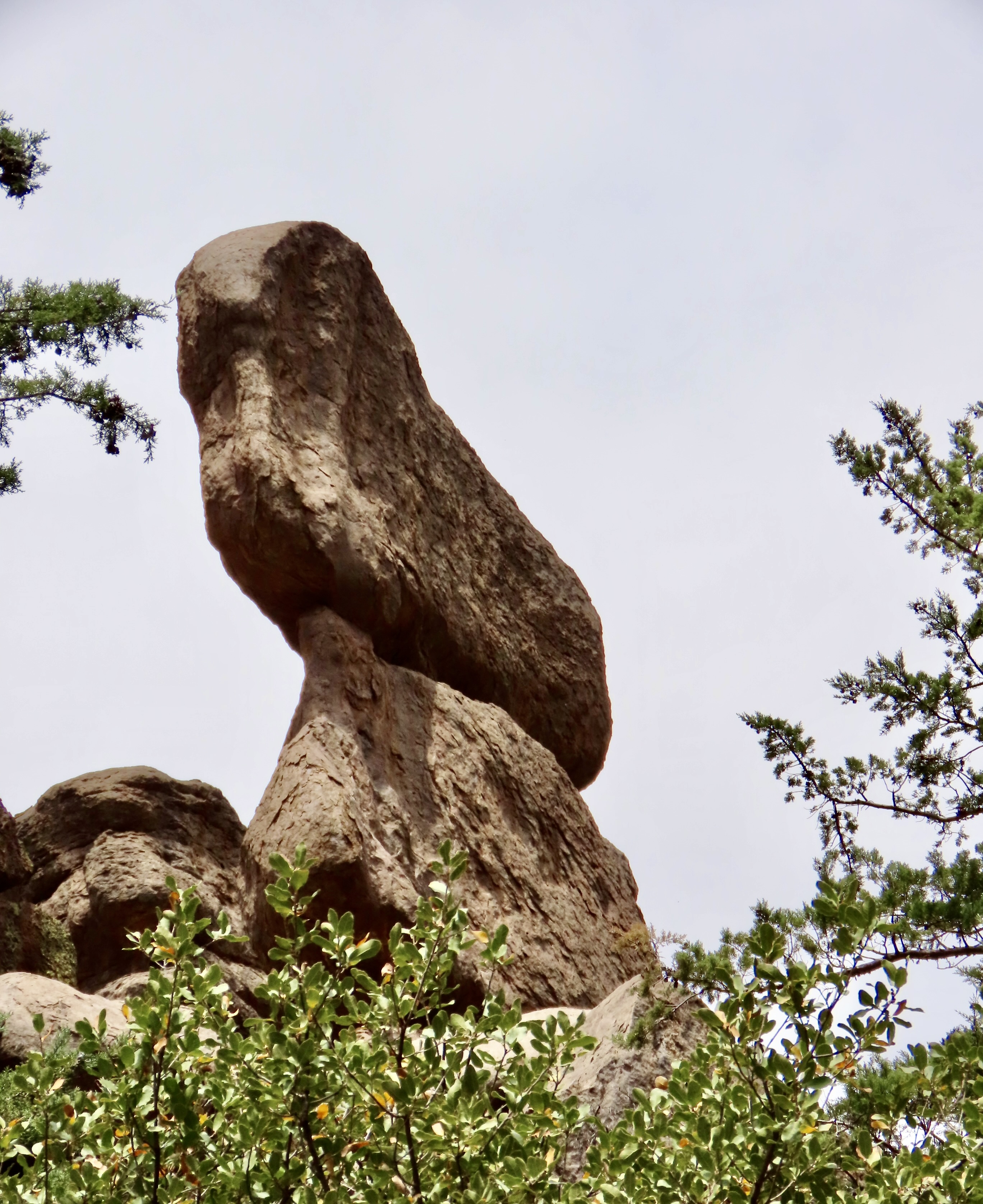
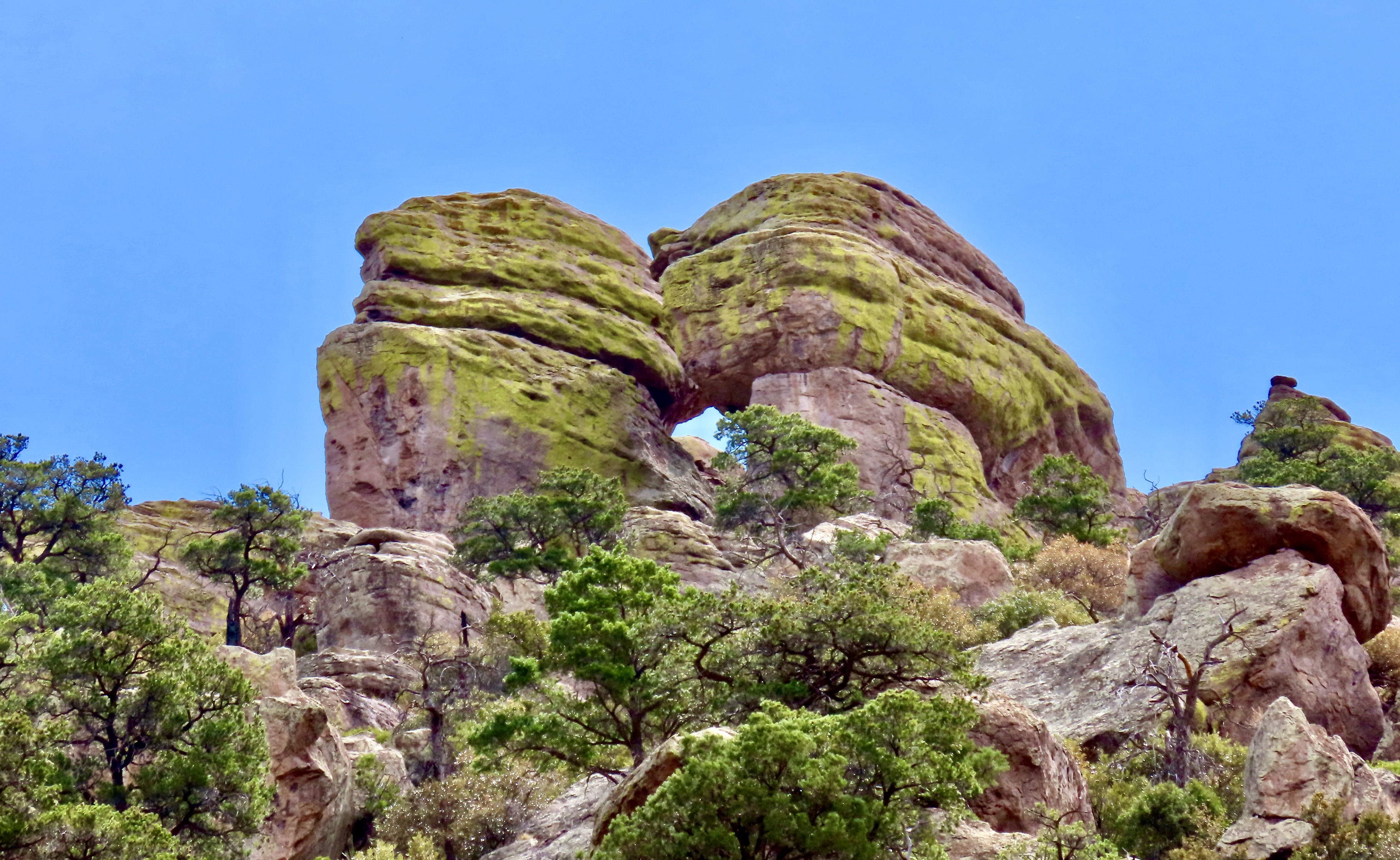
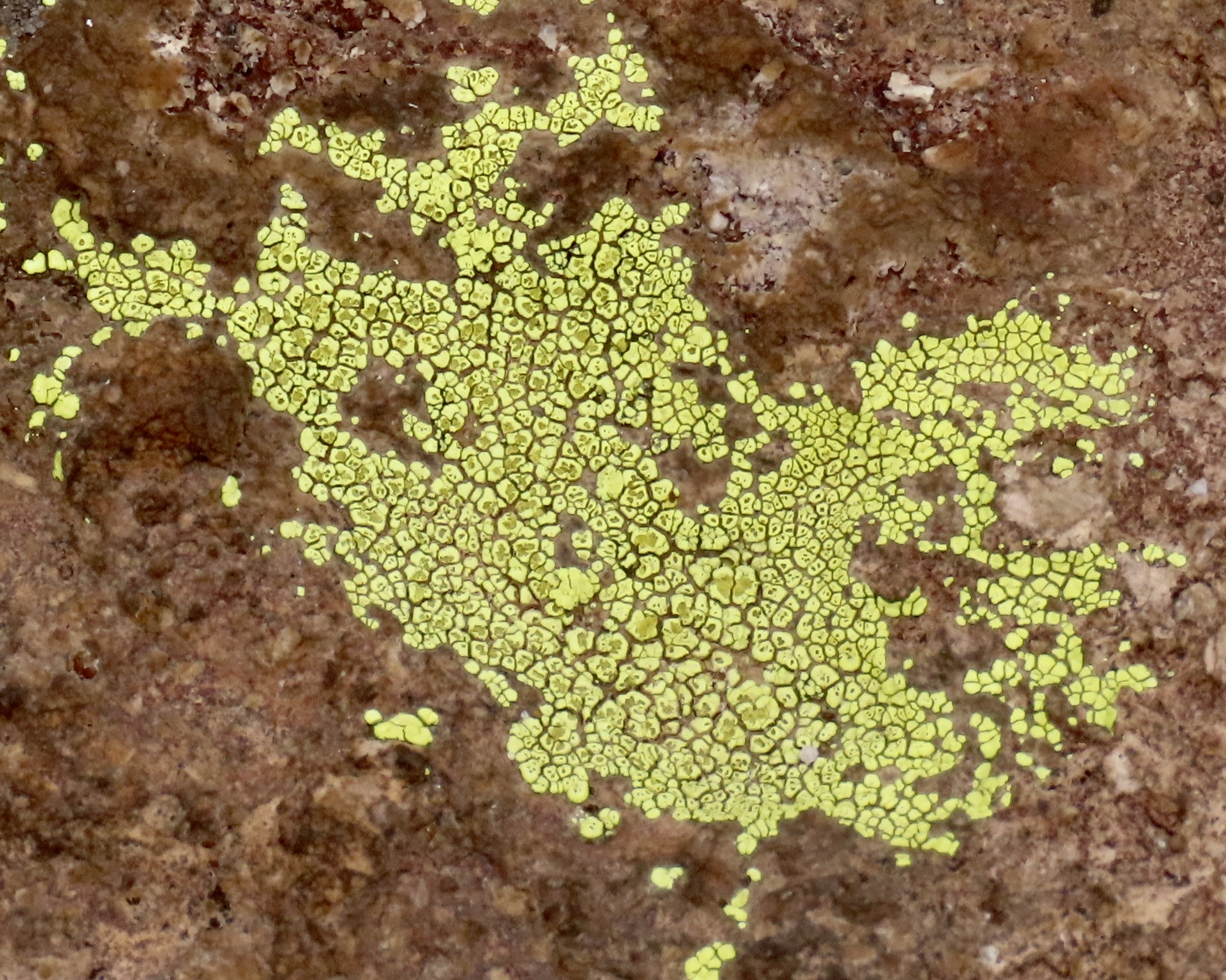
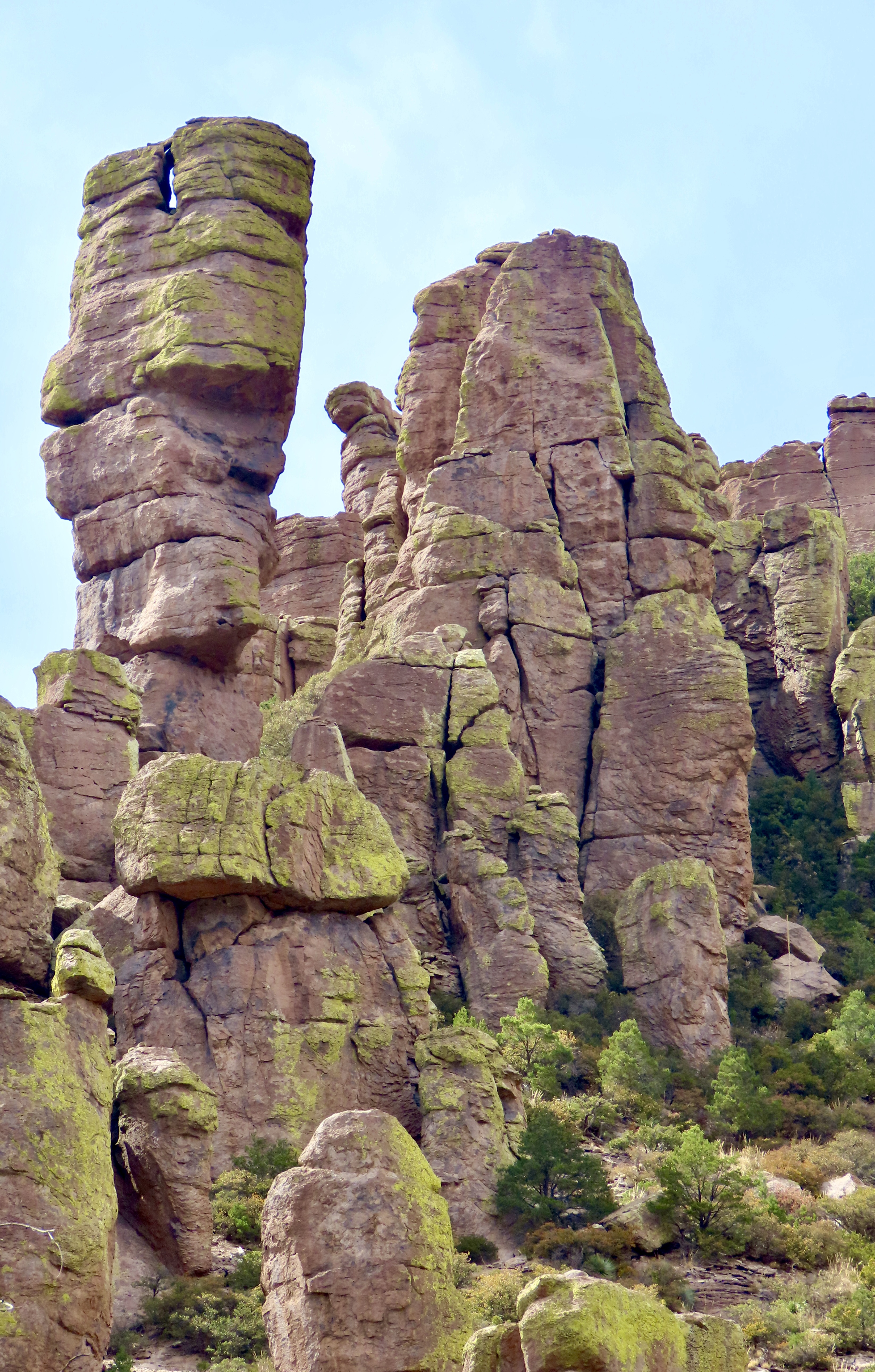
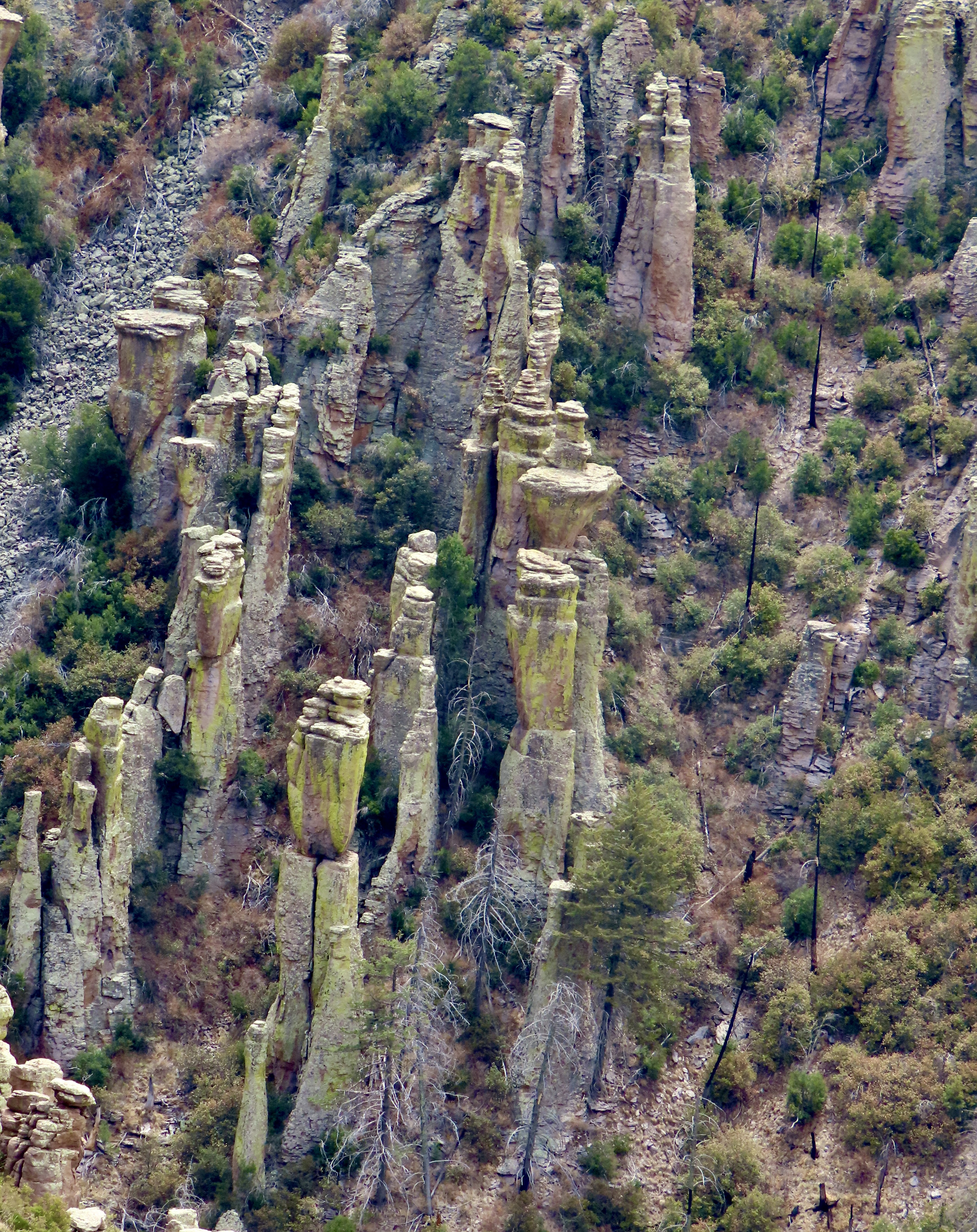
The first place that visitors usually stop at Chiricahua National Monument is the Far Away Ranch, which was built by the Swedish immigrants Emma and Neil Ericson. I think it was Emma who named the ranch Far Away because it was so darned far away from anything else. In addition to the usual challenges that settlers faced, such as irritated Chiricahua, Neil often had to work away from home for long periods to help support the family while Emma oversaw the ranch. Eventually, along with their children, they added a guest ranch to their cattle ranch. The family also became strong supporters of the creation of the National Monument. In addition to the windmill above, the ranch contains a number of buildings that tell the story of early settler life.This lizard was hanging out on the wall of one of them while scrutinizing me. (Or was it smiling?) I complimented the fellow on its camouflage.As we left the ranch and headed for the visitors center, this impressive rock monument came into view.Shortly afterwards we got our first glimpse of the columns we would soon be driving through.This attention-grabbing group of rocks was right across from the visitors center. We went in to check out the center. They are almost always a source of great information. Limited staff may make it difficult to keep them open this summer. A volunteer was busy urging visitors to contact their congressmen and women about the issue.Bonita Canyon Road was our guide into the monument. A campground was located near the entrance. The color of the trees looked like fall, but they were announcing spring.One of our first views of columns along the road was the Organ Pipe Formation towering 75 feet into the air.A closer look provides the view that is usually associated with Chiricahua National Monument. This view shows the joints (up, down and across) that allowed for the creation of the columns. We also found the crooked column interesting.Peggy was quite taken with this column because the top reminded her of a dog (eyes, ears and nose).Numerous other rocks caught our attention as we drove through the canyon including this balanced rock. Peggy thought this pair of large rocks looked like they were kissing. The green color, BTW, is created by lichen.A photo of the crustose lichen we found growing on the rocks.I was impressed with this formation along Bonita Canyon Road— and the lichen.At the end of Bonita Canyon the road made a right turn and began a steep climb up to Echo Canyon and Masai Point. We headed up to Masai Point first and were treated to the view of tall, skinny, capped-off columns.They seemed to be marching up the hill. A much different view was provided just up the trail…Short, stubby columns.Hundreds, maybe even thousands of them.They provided a view across Sulpher Springs Valley and the Distant Dragoon Mountains where Cochise had his stronghold.About a half mile down the road from Masai Point, the Echo Canyon Trail provided us with more scenic views and impressive rocks.A rock that looked bird like…A rock family.Two rocks from the same stone.And another balanced rock.We never would have guessed that Chiricahua National Monument held such treasures. But that is the story of America’s national parks, monuments and wilderness areas over and over and over. Next up, we will take you to Saguaro National Park where the giant cacti were just coming into bloom last week.
24 thoughts on “Chiricahua National Monument… It Began with a Volcanic Eruption 10,000 Times Larger than Mt. St. Helens”
As with other places you’ve visited, I’ve never heard of this one. The formations are impressive, to say the least, and it was fun seeing those lichens. Now, if only I could stop reading ‘Chiricahua’ as ‘Chimichanga.’
Laughing. Lots of good Chimichanga down in that region as wll. I’d never heard of the monument either, Linda, although the Chiricahua were quite familiar to me because of Geronimo.
It was one of the many places we found just wandering back roads. We loved it.
While working in D.C., it was my observation that much “waste” in government was mandated by Congress – pork barrel projects and the “military-industrial complex”. But across the board cuts do so much harm. The Chinese are rushing in to help and influence those countries now abandoned with the closing of USAID. The park service has struggled for years to balance capital needs while demands on their employees grew. We can only hope the pendulum swings back quickly from these drastic executive orders.
Terribly difficult to deal with the issue of ever expanding government. Divisions always want more employees and employees always want more money, just like billionaires want more billions. As for the military industrial complex, it always wants more wars. I keep waiting for Trump to tackle the Peace Corps just like he has Americorps.
The word “amazing” just does not do it! The formations are so unique! I especially like the picture of the road heading through the trees! And what a volcanic blow! I was here in Olympia when Mt. St. Helen’s told us what for! My brother lived fairly close to the area and his gutters on his house filled with ash and just fell off! You know you can still see a giant hill of ash when you travel down south over the Tootle River. My brother’s remark…we live in an exciting time! Love to you both…drink lots of water…
I had planned a bike trek for the Washington Lung Association at the time, Wendy. Needless to say, they had to change their plans. Grin. I flew over the mountain a couple of weeks later on my way to Alaska to plan a backpack trek for the Alaska Lung Association. What incredible devastation. Imaging something 10,000 times a powerful blows a lot more than my mind!
That lizard looked like he had a smirk on his face – you might want to be wary of a smirk, Curt.
That one pipe tower looked like a totem to me. And the one called a bird, looked like Aladdin’s lamp to me – do I need glasses? haha
Laughing. Beware of smirking lizards is probably good advice, G. Aladdin’s lantern would work. It was magical place. I was thinking of one of the chunky birds, like a grouse.
Another wonderful addition to the series, Curt. I really like the “tall, skinny, capped-off columns” that stand on their own – so unusual! And so funny how Peggy sees images in the rocks – I see them too! This looks like a beautiful place to visit. I hope it’s there for future generations to enjoy.
Hi D. It was a fantasy world for sure. I see faces in rocks as well. But not as many as Peggy!
The battle continues in protecting our parks. Trumps latest directive is for parks is too post signs that ask visitors to report anything rangers say or displays show that puts American history in a negative light. Sounding more an more like a dictatorship.
Thanks Lauren. It was close to a fantasy world. I just did a post on El Morro National Monument. I have one more on it and then I am going to do three on Wilderness areas along the PCT That you should consider for your backpack trek. One, of course in the Granite Chief and Desolation combination. Another is the Mokelumne Wilderness starting from Carson Pass, and the third is the Marble Mountain Wilderness starting at the small town of Seiad Valley near the Northern California border. Think of it as a route preview.
Wow, the lichen on these rocks is something else, Curt. Most of it seems like it’s hardly walkable. Thanks for the tour. What would be really cool is if you took all of us on a tour and led some groups. Maybe you would get a lot of people. I for one would sign up, seriously. I think I saw a bear but I guess it could have been a dog! That flower at the end was unreal on the Saguaro cacti! 🌵💓
Laughing, Cindy. I led backpacking and bicycling tours for over 40 years. They were fun but a lot of work. I even thought of creating an adventure tour business once up on a time. Now it’s enough if I organize Peggy and my trips. Grin.
Bear, always possible but I didn’t see it. I’ll have to go nback and look at my photos. Every once in a while, things sneak in. Thanks.
Oh I know you did and you would have had great success in it for sure. That’s funny.. I’m sure it is enough but you would have a captive audience if you open is up.
Oh, don’t trust my eyes.. lol 😂
Sometimes, it is interesting to ponder all of the things we could have done (or do) with our lives…
I checked. All sorts of animals made from those rocks with a little imagination. Grin.


As with other places you’ve visited, I’ve never heard of this one. The formations are impressive, to say the least, and it was fun seeing those lichens. Now, if only I could stop reading ‘Chiricahua’ as ‘Chimichanga.’
Laughing. Lots of good Chimichanga down in that region as wll. I’d never heard of the monument either, Linda, although the Chiricahua were quite familiar to me because of Geronimo.
It was one of the many places we found just wandering back roads. We loved it.
While working in D.C., it was my observation that much “waste” in government was mandated by Congress – pork barrel projects and the “military-industrial complex”. But across the board cuts do so much harm. The Chinese are rushing in to help and influence those countries now abandoned with the closing of USAID. The park service has struggled for years to balance capital needs while demands on their employees grew. We can only hope the pendulum swings back quickly from these drastic executive orders.
Fun on Chiricahua, Ray.
Terribly difficult to deal with the issue of ever expanding government. Divisions always want more employees and employees always want more money, just like billionaires want more billions. As for the military industrial complex, it always wants more wars. I keep waiting for Trump to tackle the Peace Corps just like he has Americorps.
The word “amazing” just does not do it! The formations are so unique! I especially like the picture of the road heading through the trees! And what a volcanic blow! I was here in Olympia when Mt. St. Helen’s told us what for! My brother lived fairly close to the area and his gutters on his house filled with ash and just fell off! You know you can still see a giant hill of ash when you travel down south over the Tootle River. My brother’s remark…we live in an exciting time! Love to you both…drink lots of water…
I had planned a bike trek for the Washington Lung Association at the time, Wendy. Needless to say, they had to change their plans. Grin. I flew over the mountain a couple of weeks later on my way to Alaska to plan a backpack trek for the Alaska Lung Association. What incredible devastation. Imaging something 10,000 times a powerful blows a lot more than my mind!
That lizard looked like he had a smirk on his face – you might want to be wary of a smirk, Curt.
That one pipe tower looked like a totem to me. And the one called a bird, looked like Aladdin’s lamp to me – do I need glasses? haha
Laughing. Beware of smirking lizards is probably good advice, G. Aladdin’s lantern would work. It was magical place. I was thinking of one of the chunky birds, like a grouse.
That would work. 🦆
What extraordinary landscapes. Thanks so much for introducing me to a park I knew nothing about.
I was right there with you, Peggy.
Another wonderful addition to the series, Curt. I really like the “tall, skinny, capped-off columns” that stand on their own – so unusual! And so funny how Peggy sees images in the rocks – I see them too! This looks like a beautiful place to visit. I hope it’s there for future generations to enjoy.
Hi D. It was a fantasy world for sure. I see faces in rocks as well. But not as many as Peggy!
The battle continues in protecting our parks. Trumps latest directive is for parks is too post signs that ask visitors to report anything rangers say or displays show that puts American history in a negative light. Sounding more an more like a dictatorship.
Then we definitely don’t want Trump on Mt Rushmore. Talk about casting America in a terrible light!
Even more than he is casting right now.
I wake up at night worrying. The man is a wrecking ball.
I try to reserve my worrying for when I read the news each day, D. And when I help Peggy debrief on the ongoing horror story.
Sigh….
Fabulous in every way, Curt, and I love the big rocks, and those short columns are interesting. Another beautiful place to visit!
Thanks Lauren. It was close to a fantasy world. I just did a post on El Morro National Monument. I have one more on it and then I am going to do three on Wilderness areas along the PCT That you should consider for your backpack trek. One, of course in the Granite Chief and Desolation combination. Another is the Mokelumne Wilderness starting from Carson Pass, and the third is the Marble Mountain Wilderness starting at the small town of Seiad Valley near the Northern California border. Think of it as a route preview.
Wow, the lichen on these rocks is something else, Curt. Most of it seems like it’s hardly walkable. Thanks for the tour. What would be really cool is if you took all of us on a tour and led some groups. Maybe you would get a lot of people. I for one would sign up, seriously. I think I saw a bear but I guess it could have been a dog! That flower at the end was unreal on the Saguaro cacti! 🌵💓
Laughing, Cindy. I led backpacking and bicycling tours for over 40 years. They were fun but a lot of work. I even thought of creating an adventure tour business once up on a time. Now it’s enough if I organize Peggy and my trips. Grin.
Bear, always possible but I didn’t see it. I’ll have to go nback and look at my photos. Every once in a while, things sneak in. Thanks.
Oh I know you did and you would have had great success in it for sure. That’s funny.. I’m sure it is enough but you would have a captive audience if you open is up.
Oh, don’t trust my eyes.. lol 😂
Sometimes, it is interesting to ponder all of the things we could have done (or do) with our lives…
I checked. All sorts of animals made from those rocks with a little imagination. Grin.