Things that Go Bump in the Night… The 10,000-Mile Bike Trek

I decided that my title today called for this 'ghost tree' I found along the Parkway. Imagine it at night with a full moon behind it and a black cat sitting on the lower branch.

I decided that my title today called for this ‘ghost tree’ I found along the Parkway. Imagine the tree at night with a full moon behind it and a black cat sitting on the lower branch.


From ghoulies and ghosties / And long-legged beasties / And things that go bump in the night, / Good Lord, deliver us! —An old Scottish Prayer

Having spent a considerable amount of time out in the woods at night, including a fair amount by myself, I’ve had my share of nighttime encounters. To say they can be disconcerting is understatement at its best. Even a cow walking through your camp can send your heart racing when you wake up from a deep sleep.

I’ve written about some of my encounters before. Why not? They make great blog material. For example, there was the time I found myself nervously loading a 357-magnum pistol because I had heard a loud bang outside my tent. A doctor friend had insisted I carry his gun in backcountry Alaska. I was damned lucky I didn’t shoot myself in the foot. I was amused (or was that embarrassed) to discover it was only a beaver that had slapped its tail against the water. He had discovered me in his territory and was protesting.

And then there was the time I woke up with a bear standing on me, his snout inches away from mine. I screamed. So much for being manly. Truth is, the smallest twig cracking out in the dark night can lead brave souls to become hyper-alert, or maybe just hyper.

Camping out in the woods away from established campgrounds on my bike trip added another level of concern, being faced with the most dangerous animal of all— the two-legged type. I’ll take a bear anytime. Breaking twigs in the night become even more menacing. As I mentioned before, I was always careful to select a place where I was hidden from the road, or any other human observation, as far as that goes.

The Blue Ridge Parkway has a policy on not camping outside of designated campgrounds. For the most part this isn’t a problem, but I had decided to have my bike tuned in Asheville and didn’t get out of the town until late in the afternoon. (Having learned my lesson on dark tunnels, I had also bought a new bike light.) A considerable hill outside of Asheville had slowed me down, and the sun had started to slip behind a mountain.

Being tired and a bit grumpy, I decided a couple of hours of bicycling were sufficient. So I pulled off the road and went looking for a flat spot in the steep terrain, one that wouldn’t have me rolling down hill all night. Eventually I found a place that was only slightly askew. There was just enough room for my tent. Blue, my bike, had to be satisfied with leaning against a tree. Tossing and turning because a rock insisted on poking me in the back, it took a while to fall asleep.

Having crested one long climb with an even longer one ahead, I decided to camp out in the woods. The steep terrain made finding a flat spot difficult.

Having crested one long climb with an even longer one ahead, I decided to camp out in the woods. Finding a flat spot other than the road was the challenge.

I woke up to someone/thing stamping outside my tent. Make that several things. I am sure you can see where this might be a bit alarming. I lay there wondering whether I should jump out of my tent or pretend that no one was home. Sometimes ignored problems go away. Sometimes they don’t. I had decided on the latter course when the problem started hissing. Stamping is one thing; hissing is another. Had the Appalachian ghosts of Tom Dooley and his mistresses come to haunt me?

This sign along the Parkway describes the origin of the Kingston Trio Song, "Hang Down Your Head Tom Dooley."

This sign along the Parkway describes the origin of the Kingston Trio Song, “Hang Down Your Head Tom Dooley.” Their song was the PG version, however. Tom was living with a much older guy who had a younger wife. With mutual consent from all parties, Tom started sleeping with the wife. When a cousin of the wife showed up, he added her to the mix, often at the same time. Another cousin appeared on the scene and Tom once more sacrificed himself for the good of all. She brought syphilis into the mix, however. Eventually, one of the cousins killed another one with Tom’s help. Being a gentleman, Tom confessed to the murder and she went free. Tom was hung. At least I think that’s how it went. I became distracted with the appearance of the first cousin. Undoubtedly, the event left some ghosts hanging around.

This was the point where I started wishing my backpacking flashlight had a ton more of candle power. I unzipped my tent and pointed the dim light up the hill where several large things went crashing off into the brush. There’s a point here. It is always better to have large things crashing away from you instead of toward you, even more so on a dark night. Anyway, I recognized the thump, thump, thump as they disappeared. A herd of several deer had discovered my hiding place, and like the beaver, been surprised and irritated. I had simply never heard deer do their stamping and hissing routine before. (I have since.)

I went back to sleep, woke up refreshed (sort of), and resumed my journey. Today’s blog photos along the Blue Ridge Parkway will take you from Asheville to Little Glade Mill Pond, a distance of approximately 170 miles. Enjoy.

The ultra modern Park Headquarters in Asheville includes all of the latest environmental friendly designs, including plants growing on the roof.

The ultra modern Park Headquarters in Asheville includes all of the latest environmental friendly designs, including plants growing on the roof.

Bike sculpture in Blue Ridge Park Headquarters, Asheville, North Carolina.

I enjoyed the bike sculpture at the headquarters.

My first stop the next day was at the Craggy Garden's Visitor's Center. It's high location provided a great scenic view of the Black Mountains. The fence was a plus.

My first stop the next day was at the Craggy Garden’s Visitor’s Center. Its high location provided a scenic view of the Black Mountains. The fence was a plus.When I bicycled through the area in June of 1989, the area was covered with blooming Rhododendrons. Peggy and I were too early for the display on our redrive of the route this spring.

Dandelions had no problem with spring. Peggy and I found them happily blooming away throughout our trip.

Dandelions had no problems with spring. They were happily blooming away throughout our trip.

Peggy insisted on buying me a neckerchief at the Visitor's Center, which featured biking the Parkway.

Peggy insisted on buying me a neckerchief at the Visitor’s Center. It featured biking the Parkway. Like the bushy look? I was honoring my bike trek where I had three haircuts in six months.

One of numerous tunnels along the Parkway. I found the stone work quite beautiful. Sone masons from Europe were brought in during the 1930s to help.

One of numerous tunnels along the Parkway. I found the stone work quite appealing. Stone masons from Europe were brought in during the 1930s to help.

This is the twin to the tree I featured at the beginning of the blog.

This is the twin to the tree I featured at the beginning of the blog. It was actually standing next to the other tree.

Dogwood is another plant that enjoys spring and was blooming in profusion all the way along the Parkway.

Dogwood is another plant that enjoys spring and was blooming in profusion all the way along the Parkway.

A close up of the dogwood.

A close up of the dogwood complete with beetle.

Dogwood on Blue Ridge Parkway with butterfly.

And a  butterfly.

Jesse Brown's cabin on the Blue Ridge Parkway.

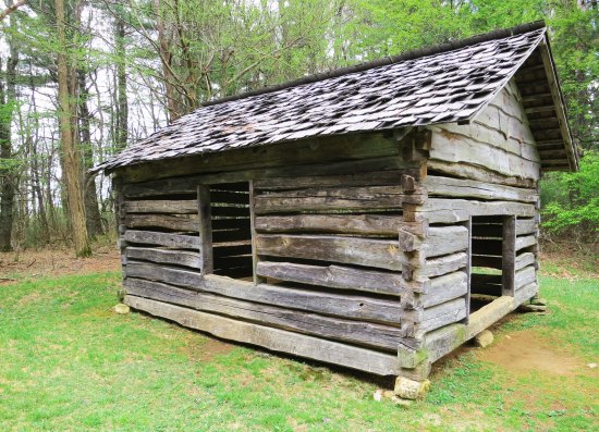
Peggy provides perspective on Jesse Brown’s pioneer cabin.

Cool Spring's Batist Church on the Blue Ridge Parkway.

The Cool Spring’s Baptist Church was next door to Jesse Brown’s cabin. Usually, services were held outdoors. There wasn’t much difference.

And the cool spring.

And the cool spring. The wooden channel carries water into the spring house.

I doubt the early pioneers would have seen this Scottish cow in the mountains.

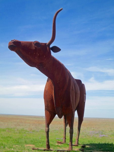
I doubt the early pioneers would have seen this Scottish bull in the mountains.

Apple tree on the Blue Ridge Parkway.

Apple trees, on the other hand, were quite common. Hard cider was a pioneer staple.

Farm on Blue Ridge Parkway.

Farm lands add as much to the beauty to the Parkway as forests and mountains.

Little Glade Mill Pond on the Blue Ridge Highway.

Little Glade Mill Pond provides a great lunch stop. While Peggy whipped up sandwiches, I hiked around the pond.

Reflection shot on Little Glade Mill Pond on the Blue Ridge Parkway.

Naturally, I had to focus on the reflection shots. Our van is off to the right. Lunch is being prepared! Breakfast is my responsibility.

I'll complete today's post with this final shot of Little Glade Mill Pond. Next Blog: We'll continue out journey along the beautiful Blue Ridge Parkway.

I’ll complete today’s post with this final shot of Little Glade Mill Pond. Next Blog: We’ll continue out journey along the beautiful Blue Ridge Parkway.


A Sizzling Sun, A Reclining Rattler, and A Hellaceous Headwind… The 10,000 Mile Bike Trek

The sun in Texas can beat down unmercifully.

The sun in Texas can beat down unmercifully. For a bicyclist on the open road in West Texas, the only escape is to cycle on to the next town.


“Only mad dogs and Englishmen (plus Curt) go out in the noonday sun.” Indian Proverb


Life becomes incredibly simple out on the road. The normal aspects of our lives— jobs, family, friends, deadlines, houses, yards, bills, etc., drop behind us. There is a freedom here: the freedom to unwind, the freedom to think about our lives, and the freedom to live in the moment.

This freedom is strengthened by the physical challenge of long distance backpacking or bicycling. The difficulty of getting through the event pulls us even farther out of our normal life while our success changes our perspective on who we are and what we can accomplish. When I led nine-day, 100-mile backpack treks and 500-mile bike treks, I could see people’s lives changing, literally before my eyes. Some profoundly.

There was ample challenge built into my day of cycling between Post and Aspermont. To start with, the temperature was pushing 80°F when I left Post around 7:00 AM. The day promised to be a scorcher. By 1:00 PM, the thermometer had climbed beyond 100 (38°C). I was down to minimum clothing and maximum sunblock, sucking on my water bottle, and worrying about sunstroke, always a danger in the hot sun. Tar began to seep up through the pavement. I climbed off my bike to take a look at the phenomena and my shoes stuck like I was walking on well-chewed gum. I noted in my journal, “I wonder if this is what the saber tooth tigers felt like when they encountered the La Brea Tar Pits in Southern California.”  I imagined my foot sinking into the pavement and me becoming a fossil for future generations to ponder over.

There were also ups and downs, a welcome change from the flat, flat of West Texas I had been cycling across. Several tributaries to the Brazos River flow through the area, cutting down through the plains. I even caught view of what Texans consider a mountain, or two to be more specific. The Double Mountains are a pair of flat-topped buttes that rise 500-800 feet above the surrounding plains and can be seen for hundreds of square miles. Pioneers traveling by horse and covered wagons used them for land marks. Native Americans probably used them to spot the pioneers.

A number of tributaries feed into the Brazos River in West Texas. Eventually the river flows into the Gulf of Mexico south of Huston.

A number of tributaries feed into the Brazos River in West Texas. Eventually the river flows into the Gulf of Mexico south of Houston.

The Brazos River near Aspermont Texas.

The river cuts through the Llano Estacado providing travelers with a break from the flat terrain of West Texas.

A distant view of the Double Mountains of West Texas near Aspermont.

A distant view of the Double Mountains of West Texas near Aspermont.

The break in terrain was welcome. My over-heated body appreciated the 20-30 mile per hour breeze generated by my downhill dashes— although it whined about the climb afterward.  There was even an occasional shade tree! The challenge here is that it becomes difficult to see in the shade when you are quickly moving between shadows and sunlight. Loose gravel, broken glass, and other road hazards lurk in the dark, waiting to provide nasty surprises.

That’s the way it was with the rattlesnake. I was racing down a hill and he/she was relaxing in the shade, enjoying the warm pavement.  I was a few feet away from a fanged encounter when I spotted him, all coiled up. I prefer my rattlesnakes rattling a warning when I approach. But there wasn’t time for him to rattle or me to think, “Oh, there’s a rattlesnake.” Instincts honed by a million years of my ancestors fearing snakes and two thousand miles of me bicycling took over. I zigged, damn lucky I didn’t land on top of four feet of extremely irritated serpent.

Heart beating like a jack hammer, I executed a U-turn at the bottom of the hill and pedaled back up to the rattlesnake. It hadn’t budged. That changed when I lobbed a couple of rocks his way (from a distance). As he grouchily slithered off the road wanting to bite someone— me, I told him how lucky he was to have encountered a bicyclist and not an 18-wheeler.

Adding insult to almost injury, a strong headwind caught me about ten miles outside of Aspermont. The wind had to be blowing at least 40 miles per hour. Tired, hot, and cranky, I dropped into my lowest gear and climbed out of the saddle. Two hours later I reached the town. My journal tells me I drank a gallon of ice tea.

Aspermont was like most of the west Texas towns I rode through: small, isolated, and slightly depressed. Employment opportunities were few. Population was going down, not up. The town’s population had been 1,357 in 1980. By 1989 it had dropped by a hundred or so.  The young people were leaving, heading off to the brighter lights of Dallas, Houston and other urban areas.

High school sports were a bright spot, however. Most towns had signs announcing when their kids had won state or regional championships, even if it was 10-20 years ago. I spent a pleasant evening in Aspermont recovering from my long day and chatting with the friendly locals who laughed at my adventures and regaled me with tales of their own. Texas is a place for story telling. That night there was another impressive thunder and lightning show, reflecting the heat and wind I had experienced during the day.

High school sports are very important in the small towns of West Texas. The local team, the Aspermont Hornets, is featured on the town's water tower.

High school sports are very important in the small towns of West Texas. The local team, the Aspermont Hornets, is featured today on the town’s water tower.

Abandoned homes reflect the dropping population of many West Texas towns. This was once somebody's dream.

Abandoned homes reflect the dropping population of many West Texas towns. This was once somebody’s dream.

The next day, I bicycled on to Throckmorton, a short 60 miles without excessive heat, wind or rattlesnakes. I was really impressed with the town’s beautiful city hall. Not so much with the local grocery store where I went to buy some fresh fruit. The oranges looked like rejects of rejects. (I admit to being spoiled by the fruits and vegetables of California.) Throckmorton is cow country so I booked myself into the Cow Country Motel and ate dinner at the Rancher’s Restaurant.

Highway 380 between Aspermont and Throckmorton.

Highway 380 between Aspermont and Throckmorton.

Some appropriate cattle on the way to Throckmorton.

Some appropriate cattle on the way to Throckmorton.

Peggy and I found this 22 foot high sculpture of a Texas Longhorn bull just a few miles west of Throckmorton.

Peggy and I found this 22 foot high sculpture of a Texas Longhorn bull a few miles west of Throckmorton. It wasn’t there when I bicycled through the area in 1989. The artist, Joe Barrington, is noted for creating  anatomically correct animals.

A side view of the sculpture, which is known as the Bridle Bit Bull. The local rancher who owns the property commissioned the art.

A side view of the sculpture, which is known as the Bridle Bit Bull. The local rancher who owns the property commissioned the art.

A side view of the City Hall in Throckmorton.

A side view of the City Hall in Throckmorton.

And a front view to conclude this post.

And a front view to conclude this post.

NEXT BLOG: A side trip to Archer, Texas, the home of Larry McMurtry and his fabulous bookstore. I also continue my bike trip on to Jacksboro and Fort Richardson, one of my favorite campgrounds on the bike trip.


A Huge Bull, a Blinding Snowstorm, and an Insane Downhill… The 10,000 Mile Bike Trek

The Sierra Nevada Mountains as seen from a road leading into Porterville, California.

The Sierra Nevada Mountains as seen from a road leading into Porterville, California. They appeared to be floating in the sky. (Photo by Peggy Mekemson.)


Greenhorn: a person who lacks experience and knowledge.

There came a time when I was out of options. I had gone as far south in California’s great Central Valley as I cared to go. It was time to head east. It was time to leave the flat lands and climb over the massive Sierra Nevada Mountain Range. They were looming ominously in the distance.

Another view of the Sierras from the Central Valley. These two photos were looking north. I would cross over to the south several thousand feet lower.

Another view of the Sierras from the Central Valley. These two photos were looking north. I would cross over to the south several thousand feet lower. (Photo by Peggy Mekemson.)

I was no stranger to the Sierras. I had been raised in their foothills and spent 15 years leading hundred-mile backpack trips up and down its spine. I had hiked their length and breadth. I’d even biked across them a couple of times. But was I ready for them, now? Had my week of biking down the Central Valley prepared me for the tough climbs I knew were ahead of me? Were my knees and fat cells ready for the challenge?

There was only one way to find out.

I spent a half day in the town of Porterville having my bike tuned up. The town perches on the edge of the foothills and the edge of the valley. When I left the town, I would literally begin my climb. As usual, I picked a remote route. My plan was to start off on a country lane with the name of Old Stage Road. It wanders through the foothills and eventually runs into Mountain Road 109 which morphs into Jack Ranch Road before finally dropping down to Highway 155 at Glenville.

From there I would begin my climb up and over Greenhorn Pass, the true test.  I wasn’t a greenhorn, but I was feeling a little green. Kermit would have seen me as a soul mate. I had never been over the road. I had no idea of what lay before me. My goal was to reach Isabella Lake, a reservoir east of the city of Bakersfield and, for me, the gateway to vast desert lands of the Southwest.

Leaving Porterville after lunch, there was no way I would make the 60 miles in one day, however. So I lollygagged. Why hurry? Orange trees greeted me as I biked out of town. Sampling one led to sampling two. California grows great oranges. Eventually the fruit trees stopped but it was a beautiful spring day and the hills were gentle. Luscious green grass was sprinkled with cheerful flowers. Happy cows munched away out in the meadows.

One of the orange trees I biked by near Porterville.

One of the orange trees I biked by near Porterville.

The road worked its way through the foothills that were coated with spring green.

The road worked its way through the foothills that were coated with spring green.

Rock outcroppings along the road were quite beautiful.

Rock outcroppings along the road were quite beautiful.

As were the flowers, such as these California Poppies...

As were the flowers, such as these California Poppies…

And these carpets of white flowers further up in the foothills.

And these carpets of white flowers further up in the foothills.

After some 30 miles, I began looking for a place to land along Mountain Road 109. Forget campgrounds or motels. There weren’t any. A babbling brook caught my attention. It was hidden by trees in a small canyon beside the road. The trees would also hide me. All that stood between me and Shangri-La, was a barbed wire fence. I hadn’t seen a car for 15 minutes and didn’t hear any coming so I quickly took off my panniers and tossed them over the fence, followed by my bike and then me with nary a tear in my clothes. Barbed wire has a nasty disposition. Panniers, bike and I then disappeared into the trees where I set up a pleasant camp a few feet away from the stream. I went to sleep that night to the gentle sound of water cascading down the canyon and a talkative hoot owl.

I could hear a creek hidden down in the trees on the other side of a barbed wire fence that was designed to keep cattle in. But was it designed to keep bicyclists out?

I could hear a creek hidden down in the trees on the other side of a barbed wire fence that was designed to keep cattle in. But was it designed to keep bicyclists out?

A charming stream beckoned.

A charming stream beckoned.

I awakened by a deep, loud, low moo, the type that comes from 2,000 pounds of bull. I couldn’t see him, which meant he couldn’t see me. That was the good. The bad part was that he was between me and the fence. I set about whipping up breakfast on my small backpacking stove, hoping the bull would move along. He didn’t.

As I was loading my panniers, I was struck with how red they were. Bull fighters use red capes, right?  They make bulls angry and encourage them to charge. With a certain amount of don’t-want-to, I picked up my bull-charging panniers and headed toward the fence. The bull was pressed up against the fence and was as big as his moo. His bull-hood almost dragged the ground. He glanced at me disdainfully and returned his attention to staring across the road. I was saved by two girls. A pair of pretty heifers were making cow eyes at him. He could have cared less about me. I didn’t push my luck, however. In a flash, my bike, panniers and I were over the fence and on our way. But not before thanking the girls.

Peggy and I found this Texas Longhorn not far from where I had my bull encounter. The bull didn't have horns like this but he was a heck of a lot bigger!

Peggy and I found this Texas Longhorn not far from where I had my bull encounter. The bull didn’t have horns like this, but he was a heck of a lot bigger!

Two hours later I was eating my second breakfast in the tiny town of Glenville. A pair of old timers eyed me suspiciously. “Where you heading?” one asked. “Over Greenhorn Pass,” I’d replied.

“Oh, I wouldn’t do that. There’s a storm brewing up there today. It’s supposed to snow like crazy. You’ll freeze to death.” He warned me enthusiastically.

“That’s nothing,” his friend declared, not wanting to be outdone in the local doomsday competition. “It’s the drop off on the other side of the pass you need to worry about. Bike brakes can’t handle it.”

Peggy and I found this fun display in Glenville. I didn't remember it from my bike trip.

Peggy and I found this fun display in Glenville. I didn’t remember it from my bike trip. The restaurant is on the other side.

Remember the days when gas was $.40 a gallon? Probably not...

Remember the days when gas was $.40 a gallon? Probably not…

I suspected that the guys were having a bit of fun at my expense so I headed off with only a slight twinge of concern. My attitude changed when I was flagged down by an RV driving down the mountain I was struggling up. “I couldn’t believe how steep it is coming up the other side,” he told me. “I wouldn’t go down it on a bike.” My worry level jumped from a .01 out of 10 to a 9.99 in a nanosecond. But the only option would add a hundred miles. I labored on.

The distant road snakes its way up the mountain toward Greenhorn Pass.

The distant road snakes its way up the mountain toward Greenhorn Pass.

Peggy and I climbed the pass in our van under much more pleasant conditions but these trees mark our elevation gain and are near where the snowstorm started.

Peggy and I climbed the pass in our van under much more pleasant conditions but these trees mark our elevation gain and are near where the snowstorm started.

Thirty minutes later it started snowing. It wasn’t a blizzard but the snow was coming down fast, in large flakes. Visibility was limited. It was cold. I stopped to put on more clothes. At least, I thought to myself, if everyone is right about the drop off on the other side of the pass, I’ll be below the snow-line quickly. It was small consolation— like jumping from a freezing boat into icy water. And first I had to make it to the top. Hypothermia was a real concern. I tried riding but bicycling in the snow without studded tires is difficult and dangerous. So I got off and walked. Summer cabins off to my right caught my attention, but they were still boarded up.

Fortunately, I hit the top in a couple of miles and I wasn’t frozen solid. Better yet, the snow had turned to a few fluttering flakes, and the road off the pass was wet but not covered in slush. I’d survived the bull and the snow, but what about the downhill. A sign announced a 13% grade; 6% is usually enough to post a warning. I thought fondly of the apartment I’d left behind in Sacramento. But what the hell, life’s short. I climbed on my bike and started down. Soon, I was smelling my brakes, like a semi out of control. It was a long, long downhill. I stopped often to let the brakes cool. Even with that, my wheels had lost their true and were slightly warped by the heat when I hit the bottom.

Greenhorn Summit

Greenhorn Summit as it looks on our present trip to retrace my route.

Eeyore peered out the window checking out the elevation. Shortly afterwards he had covered his eyes with his ears as Peggy started driving down the mountain. Even though we were using low gears, we could soon smell our burning breaks. The trip down was as scary as it had been on the bike.

Eeyore peered out the window checking the elevation. Shortly afterwards he had covered his eyes with his ears as Peggy started driving down the mountain. Even though we were using low gears, we could soon smell our burning brakes. The trip down was as scary as it had been on the bike.

I found another motel and declared another layover day. I’d earned it. The motel owner told me that a couple had biked off the pass the week before and then hitchhiked 50 miles into Bakersfield to have their wheels trued. I managed mine with a spoke wrench. Given my mechanical aptitude, it was a small miracle.

NEXT BLOG: Into Death Valley. (Peggy and I will soon be disappearing into a remote part of Canada and may not have Internet access. Also, as noted before, all photos are from the trip we are present on.)