In 1980, the American Lung Association of Washington invited me to help plan a 500 mile bike trek to Mt. St. Helens as a fund raiser. At the time I was serving as the national consultant to the American Lung Association on long distant backpacking and bike treks as fundraisers. I had created the concept and written the how-to manual. I flew up to Seattle and worked with the staff in planning the trek. As often happened with events I helped organize, they invited me to go along. Tempting. The trek covered a lot of beautiful country and looked like great fun, but I was supposed to be in Alaska helping to organize a backpack trek across the Kenai Peninsula around the same time. The rest is history.
On May 18, several weeks before the trek was to take place, Mt. St. Helen’s blew her top. It was fortunate that it hadn’t happened in the middle of the event! ALA Washington quickly arranged another route. This isn’t the end of the story, however. I was flying to Alaska six weeks after the explosion and the pilot flew us over the mountain. The devastation was incredible. It has lived in my mind ever since. In 2013, Peggy and I took another trip up to Alaska, this time driving the Alaska Highway. On the way back we stopped off at Mt. St. Helens. I did a post at the time. In honor of the 40th Anniversary of the eruption, I am reposting it today.
It was in early July 1980 and I was flying north to help plan a hundred-mile fundraising backpack trek in Alaska. The pilot deviated from his route to show us Mt. St. Helens.
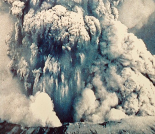
It was total devastation, a scene from Dante’s Hell.
A month and a half earlier, on May 18, Mt. St. Helens had blown her top, literally. On May 17 the mountain had stood 9677 feet tall; on May 19 it stood at 8,364 feet. The mountain had a history of being the most active volcano in the Cascade Range of volcanoes— mountains that dominate the skyline of the northwestern part of the US and are part of the ring of fire that stretches around the edges of the Pacific Ocean.

Peggy and I call the Cascade Range home, now. In fact I have climbed two of the mountains, Shasta and Lassen, and we see a third, Mt. McLoughlin, every time we drive the 30 miles into town for groceries. Normally we think of the mountains as dormant and a beautiful addition to our region. But all are capable of awakening. And all are capable of spewing disaster.
Weeks before Mt. St. Helens blew up, she had been showing signs of an imminent explosion. Couched between the two major urban areas of Portland and Seattle, the area had become a mecca for tourists, volcanologists and, of course, the media. Worldwide attention was guaranteed.
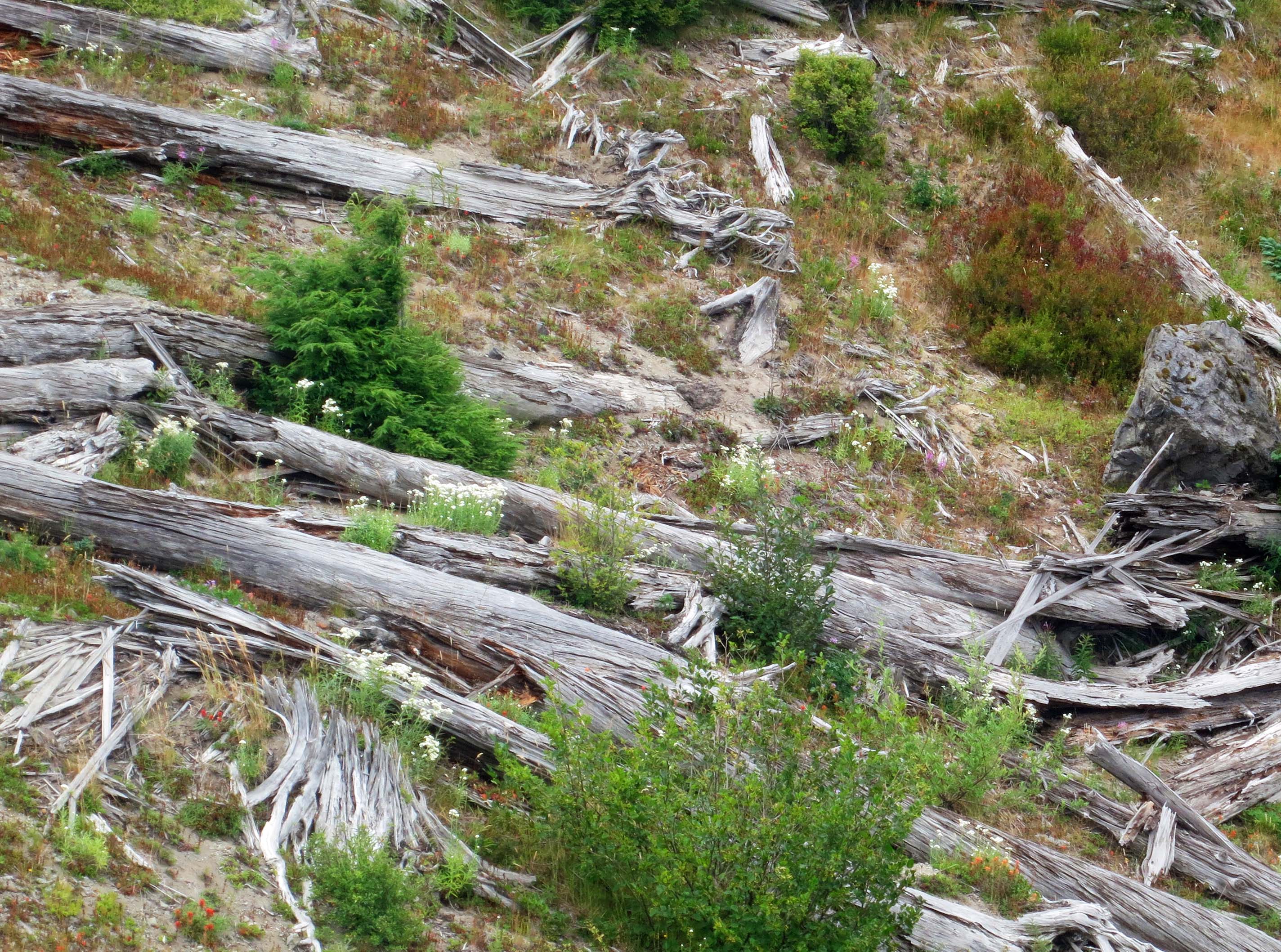
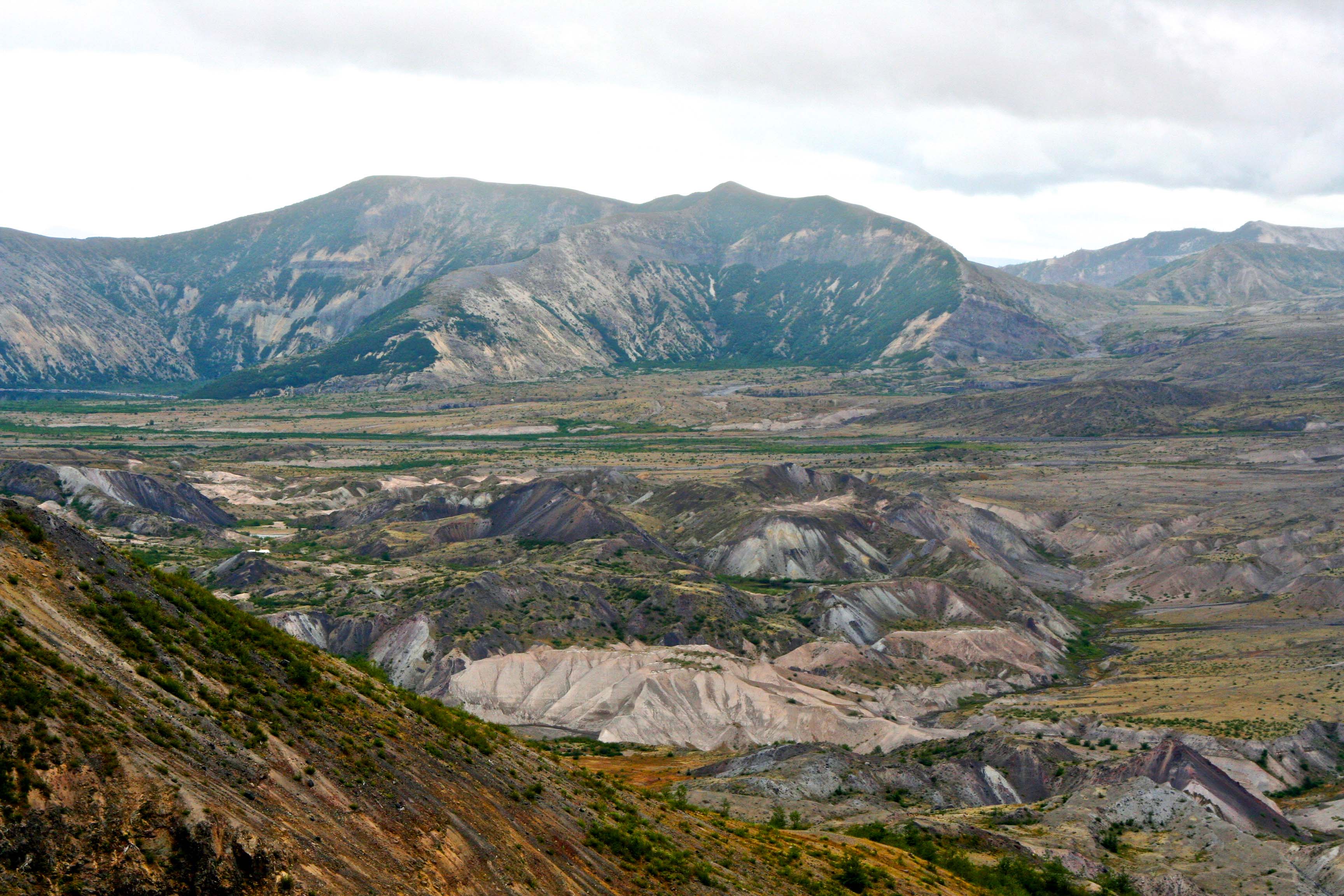
The explosion, when it came, was much more devastating than had been expected. A huge, lateral blast sent a cloud of dense, super hot steam filled with debris rolling down the mountain at 300 miles per hour and devastating an area of 230 square miles. Next to the volcano nothing was left. Starting at about seven miles, thousands of trees were snapped off at their base and laid down pointing outward. Further out, a narrow zone of trees had been left standing but the trees were scorched beyond recovery.
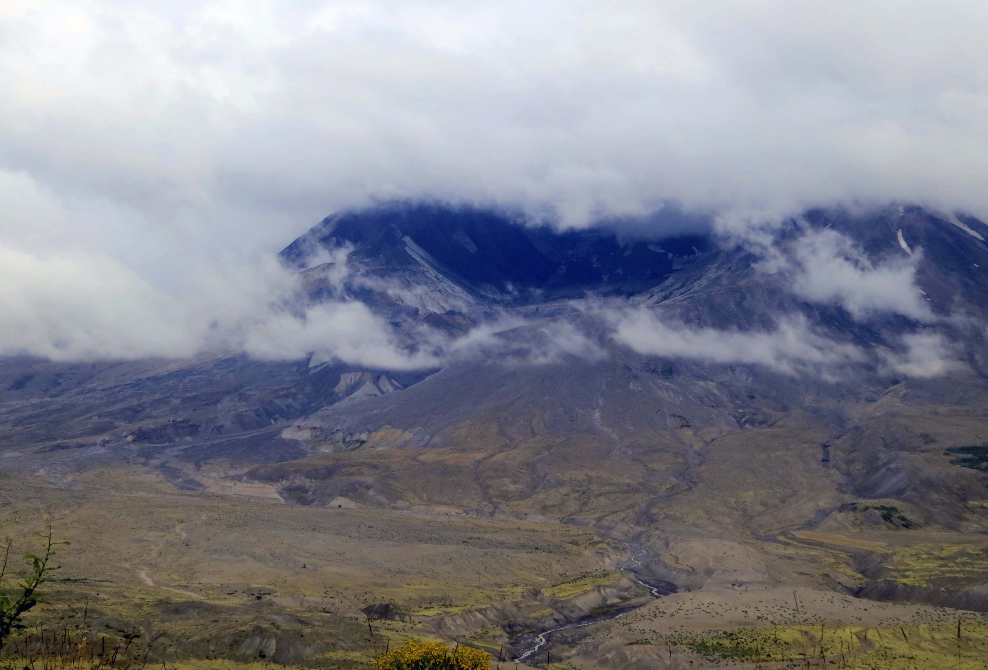
The side of the mountain that was blown away added to the disaster. Crushed rock and melted glacial ice joined with downed trees and rushed into Spirit Lake and down the Toutle River travelling at speeds up to 150 miles per hour. Hummocky deposits between 150 and 620 feet high were left behind.
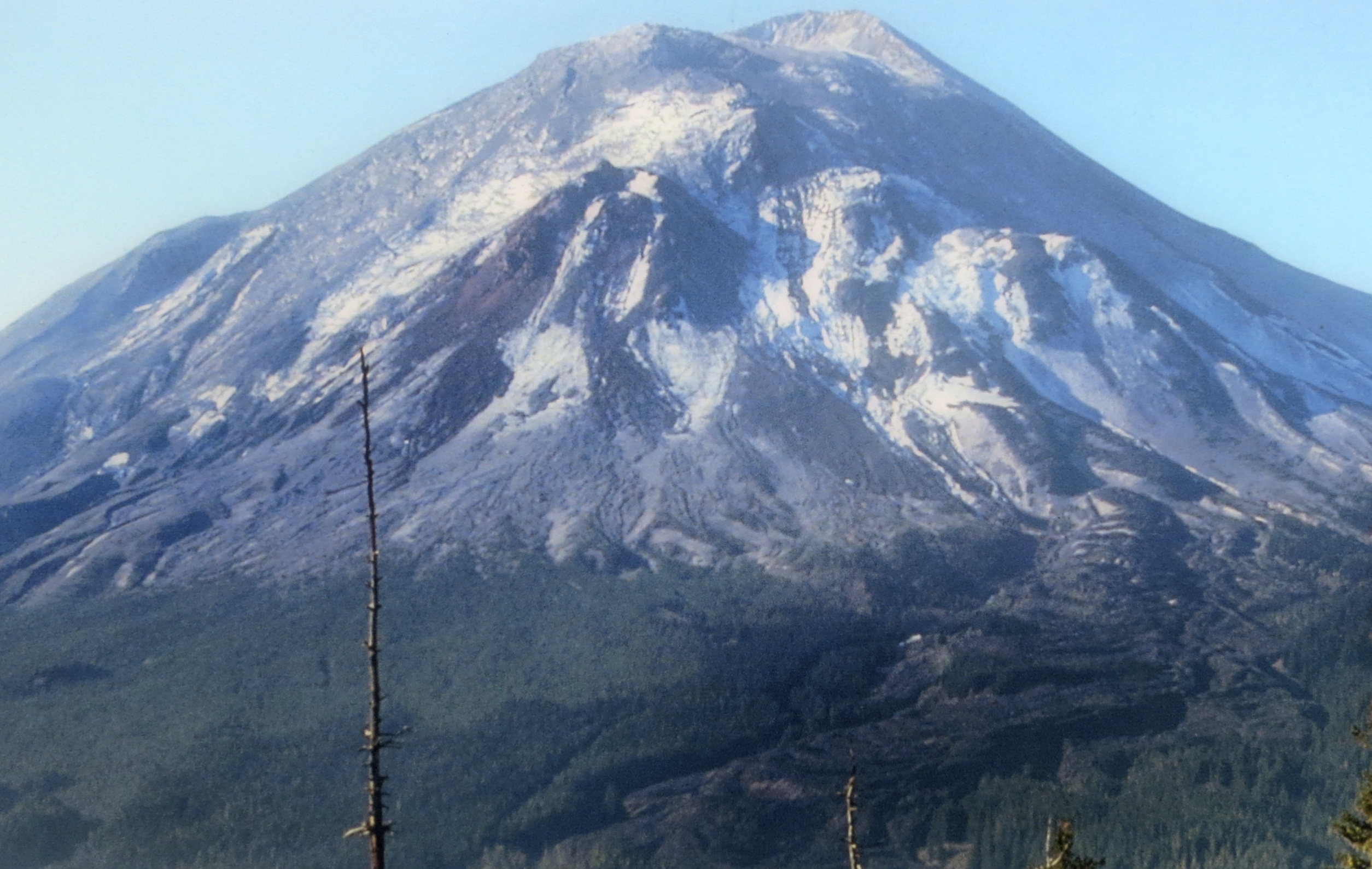
Today, Mt. St. Helens stands as a National Monument to educate people about volcanoes and the recuperative power of nature. Three visitor centers tell the story extremely well. Peggy and I have driven by the area several times and promised ourselves each time that we would visit. Finally, on our trip back from Alaska, we succeeded.


NEXT POST: Tomorrow we return to Venice.

I remember when she blew – I had forgotten the US even had volcanoes (except that huge one under Yellowstone), at the time!!
It’s something that you remember when you live in the middle of a volcano chain, G. They don’t go often, but when they do… Of course, you get to play with hurricanes. 🙂
Oh yeah – they’re always fun! 🙄
I well remember when Mt St Helens blew. Especially remember the folks who said they planned to stay even though an eruption was certain.
Hard to fathom, Peggy. You can only wonder why. I would have been out of there so fast a jackrabbit couldn’t have caught me. –Curt
DANG!!! Those are some pictures!
It’s a fascinating place to visit, MB. The National Monument has done a superb job with its visitor centers. Thanks. –Curt
Someday I may, but you know I’ve always been a little leery of volcanoes, even when they’re deemed safe haha!
You won’t find me around one that is rumbling, MB! 🙂 But most are as safe as say, driving through earthquake country.
I so remember when it blew. We lived in Denver at the time and ended up with a dusting of ash on our driveway. I had no idea that it would travel that far. Fast forward and now we have two grown daughters living in Seattle area and every time we fly in to visit and we have a view of it….it never ceases to be amaze me looking at the portion of the mountain that was blown away! Great post!!
Curt, please add Nan to your mailing list. Thanks. goodnan779@gmail.com
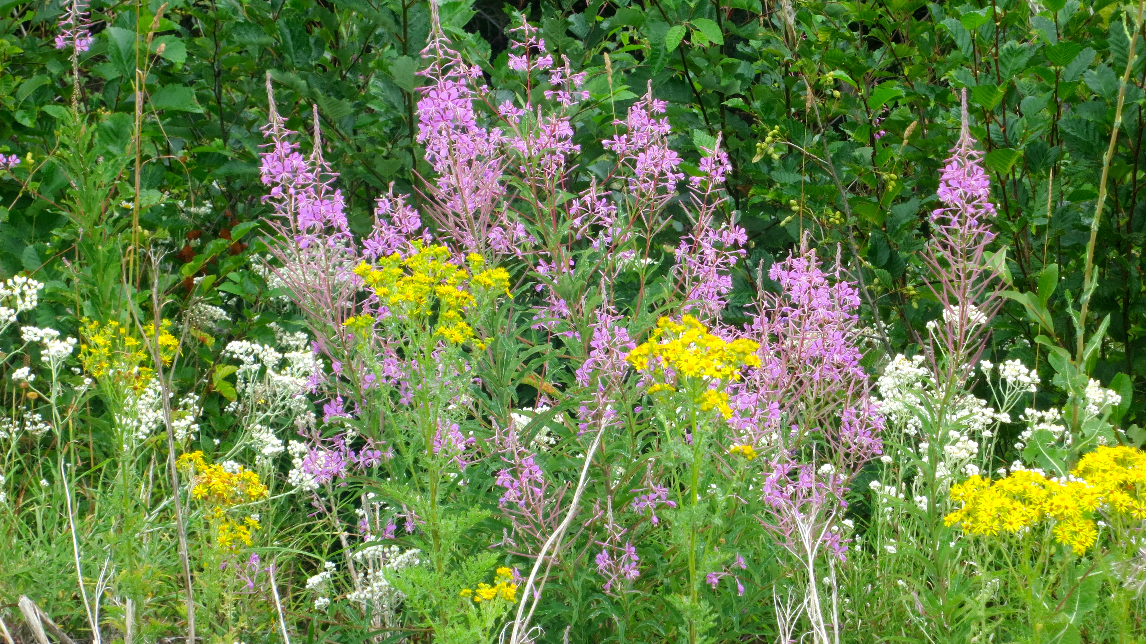
And here I am trying to get some fireweed to grow!!! 😦
Our deer seem to like it for dessert.
Oddly enough I’ve never been tempted to visit Mt St Helens. I’m thinking I was still somewhere in El Dorado county when it blew.
I’ve always said I’d rather have a hurricane than an earthquake, and I think I might apply the same reasoning to volcanoes. Hurricanes aren’t wholly predictable, but they do give you a better shot. Of course, those seismic experts can make predictions, but still…
I have a friend who grew up in Sicily. Instead of going to the drive-in movies, they’d just sit around and watch Mr. Etna. And of course there’s always a song!
A bit to close for comfort!
Agreed! One of the men in my Cherokees group likes to tell a close call story too. He was flying home from Seattle and the flight path goes right over the mountain, as Curt was explaining. He says his flight was early in the morning, May 18. He landed, and collected his stuff and left the airport, and then it blew.
Lucky break for sure!
Like the old Jimmy Buffet song…
Like the Jimmy Buffet song: Ground she’s moving under me
Tidal waves out on the sea
Sulphur smoke up in the sky
Pretty soon we learn to fly. 🙂
I’m never sure which is worse, fire, flood or volcanoes. They all seem able to devastate large areas. We’re luckily nowhere near a dormant or live threat.
I’d add in earthquakes. 🙂 And they tend to go along with volcanoes. –Curt
It is stunning how fast mother nature moves to repair herself.
Yes, Greg. It really is. Another example is recovering from fire. Since we live in forest fire country we get to see a lot of that. Also, Yellowstone is a great example. –Curt
Curt I’m so glad you and Peggy got to visit. It’s a long drive out that road to the Monument, but I think so worth it. Mt. St. Helens is the closest volcano to me, and I see the distinctive truncated top every time I leave my driveway, as it’s just across the river. I have been able to make multiple visits to the monument because it’s only an hour and a half from my house. You said it was famous for being the most active volcano. I didn’t live here at the time, so I never heard that, but it’s certainly active now. In the wintertime it’s easy to see. The mountain will get a fresh layer of snow, then within a couple days the snow is all covered in ash. St. Helens still grows and belches and spews ash, nearly every day. Which is GOOD! It’s letting out that pressure so it doesn’t blow up, thank goodness.
I had a thought for the very first time while reading your blog today. I was thinking about how it blew north, and that destructive avalanche of glacier and stones and ash tore through Hoffstadt Creek and the Toutle River valleys which are pretty remote. Just imagine the potential destruction if it had blown southwest. It’s just over 30 miles to the Columbia River. That could have been so much worse.
Peggy and I were really impressed with the job the National Monument has done with it’s visitor centers, Crystal. Especially the one up on top where they show the impressive video of what happened and when the video ends they raise the screen to reveal a huge picture window that looks out on the mountain.
As for damage, visiting places like Pompeii really help to visualize the potential damage. –Curt
Oh yes!! What drama! The curtains open and there’s the mountain, as you had just been staring at it on the screen. Someone was thinking when they planned the screening room.
They certainly were, Crystal. It has to be the most dramatic national monument/park display I have ever seen. –Curt
Nice writeup. I learned how to fly in the late 80s, and making the trip from Hillsboro Airport to Mt. St. Helens was one of my regular jaunts. It never got old. I stopped flying about 15 years ago (but every time a light plane flies over on a nice summer day I get the itch.) I bet the up-close mountain view has changed quite a bit since then.
One of the advantages of driving up and seeing it from the ground is to see the size of the trees that were blown over like matchsticks. Some of them were huge!
Were you living in Portland when it erupted, Dave? That’s about as close as I would have wanted to experience it. The trees certainly told a dramatic story.
I can imagine it was interesting flying up and seeing the changes. –Curt
Yeah, I was here already. The day of the first big eruption (there was a small one in March) the winds were from the west and the skies were overcast, so we weren’t much affected. (But Yakama got a huge load of ash.) We did get ash on subsequent eruptions but not a huge amount; maybe 1/4 to 1/2 an inch. It was pretty dusty around here for a while, giving us an excuse to wear masks back then too. Of course, there was that one day it rained mud…
It’s such an eerie place, isn’t it? Especially listening to the recording at Johnston Observatory- “Vancouver, Vancouver, this is it!”…and it was. Last time we tried to visit was during all of the wildfires so the crater was hidden, but it might be time for another road trip, once those are allowed…
Thanks for sharing, Curt!
I remember when this happened. One has to see the area to be able to grok the magnitude of the event. In some ways beyond what one can imagine. And yes, the volcanic spill off is so rich that plants seem to regenerate as soon as the ‘soil’ cools down. If I recall correctly the ash from the explosion travelled along air currents and circled the planet.