A Journey to the Kingdom of Dust… Burning Man 2017: Part 1

Truer words have rarely been spoken at Burning Man. I came across the sign on the Playa this year. After a major dust storm at Black Rock City, eyes, ears, nose, mouth and clothes are coated in dust! And everything else, as far as that goes.


Maybe I should title my post journey interruptus, since my first attempt at reaching Burning Man was squelched by the need to hurry home and pack up valuables in case our house was burned down by one of the forest fires raging near us in Southern Oregon.

By Wednesday, Peggy and I had done what we could to secure our home, made up our minds on what to take, and decided that escaping the smoke was our next priority. It was laying in thick, refusing to go away, limiting our vision, and, much worse, settling into our lungs. Peggy was heading to Sacramento to stay at her sister’s and visit with her 97-year-old mom. I would resume my journey to Burning Man.

We wished our house well. I wandered around inside saying goodbye to treasures— memories that dated back decades— and then went outside to wish the beautiful surrounding forest good luck. So far, the fires had been kind, cleaning out the debris under the trees while, for the most part, leaving the trees to prosper. Forest fires are a natural part of ecology, a natural means of keeping forests healthy. I suspect Smokey Bear would shed half his hair over this thought.

We gave each other a final hug and headed out for our different destinations.

Not to keep you in suspense, our house still stands. On Thursday, a week ago, the Level 1 alert went to a Level 2: “You should be packed up and out.” Neighbors reported on seeing the flames creep over the ridges and make their way down toward out homes. But so far, we haven’t received a Level 3, “Get out now!” message. The firefighters made a valiant effort at slowing down and stopping the fire’s advance with very limited resources. (Resources are limited because the whole West seems to be burning. Teams are moved rapidly from one fire to the next depending on needs.)

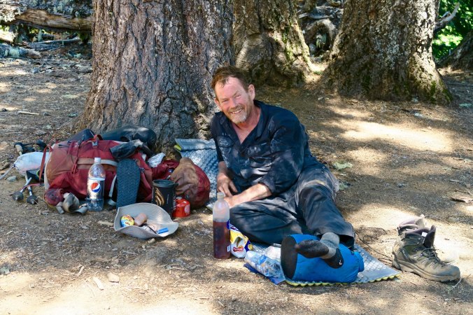
Back again in Southern Oregon after Burning Man 2017, my faithful horse and I were glad to find our house still standing. The horse, BTW, is affixed to my bike so I can find it in the middle of thousands of other bikes. The glow sticks help us to be seen at night. My beard, soon to be gone, is courtesy of my summer backpacking trips. Smoke from the fires still hangs in the sky. (Photo by Peggy Mekemson.)

My second effort at driving to Burning Man was more successful. I didn’t even stop in the small town of Cedarville where I had turned around the first time. The road makes its way south out of town down through Surprise Valley, which is a surprise because it has water, and then jogs east out into the Nevada desert on lonely Highway 447 toward Gerlach. I must have passed all of four cars on my 60 plus miles of driving through the Black Rock Desert. At Gerlach, a left jog on Highway 34 for eight miles took me out to the entrance road to Burning Man.

I swear that vehicles escaping from Black Rock City breathe a hefty sigh of relief when they finally reach Highway 147. I watched as a few came out, hit a bump, and exploded in dust, like a dog shaking off water. And then it was my turn to drive in over the dusty, bumpy, dirt road. Here’s the thing, it isn’t that long, maybe five miles, but it can take five hours to drive over during peak hours. Put in perspective, that’s about the same amount of time it took me to drive the 280 miles from Medford to Gerlach.

Almost everyone who attends Burning Man, from virgin to veteran, has a story to tell about the experience. There are several factors that can cause delays. The number of people entering or leaving in a given period is the primary one. Put several thousand people on the road at the same time and it can make driving over a LA freeway at rush hour seem positively delightful. BMORG, the Burning Man Organization, doesn’t help. It is so paranoid about someone slipping in without paying that every vehicle entering is searched from top to bottom. I had to get out and open the back door of my van (admittedly, there is room to store a bicycle pump or a very small midget) and then let the ticket checker in to look under my bed and in the bathroom. It took ten minutes. Multiply that by several thousand.

Speed limits make sense. It’s 10 miles per hour on the road in and 5 miles per hour in Black Rock City. There are numerous police around to enforce the law. Bumpy roads add their own speed limit. This year featured the mother of all washboards. I watched an RV in front of me bounce around like Jell-O during an earthquake.

The weather is always a factor. Massive dust storms are natural, and the vehicles whip up their own, given that the dust on the road is often several inches deep. Close to zero visibility is possible. More than once, I’ve driven from traffic cone to traffic cone hoping that they wouldn’t disappear altogether. Then I hoped the next one would appear beside me, and not under the tires of my van.

This is what the road into Black Rock City looks like during a heavy dust storm through my window. I’ve used this photo before. A car disappears and you can barely see the traffic cone on the lower left. Not fun. Fortunately, conditions were better this time.

Rain stops everything. The fine dust turns into a sticky clay that gloms on to vehicle tires, bike tires and shoes— inches thick. Vehicles are required to stop, and who would want to walk or bike in the stuff. Peggy and I once waited on our way in for three hours as the road dried out enough for people to drive over it. A massive party developed. People were dancing on top of RVs and entertainers were performing on the road. Garbage bags tied over feet provided a solution for those who chose to walk around. We had good books to read, which we always carry, just in case.

I hate to mention this, but a Nevada forest fire helped me on the way in this year. It actually blocked traffic on Highway 147 from Interstate 80, which is the main way into Burning Man. I could see the clouds of smoke roiling up in the distance. With minimal traffic, it only took an hour and a half to reach Black Rock City!

The wind was whipping up a dust storm when I arrived. My lungs started screaming at me. I had just subjected them to a week of smoke in Oregon and now they had to deal with Playa dust. They were not happy. I grabbed the first vacant space I found, which was at 6th and L and then took out my camera to photograph the disappearing camp next to me. I had arrived at the Kingdom of Dust.

My location in Black Rock City this year is shown by the yellow dot. I was on the farthest road out.

Shortly after I arrived at Burning Man 2017, the camp next to me began to disappear in a cloud of dust. This is around 3:30 in the afternoon.


NEXT POST: Some general observations on Burning Man 2017… and lots of photos.

SaveSave

SaveSave

SaveSave

SaveSave

SaveSave

SaveSave

SaveSave

Burning Man or Burning House… When Forest Fire Threatens


Heavy smoke from local forest fires fills southern Oregon’s Upper Applegate Valley where we live.


I left our home on the way to Burning Man with the heavy smoke of the surrounding forest fires filling the air in Applegate Valley like an evil fog. Once again we had an inversion; there was nowhere for the smoke to go so it was hanging around and hassling our lungs.

The forest service folks said there wasn’t much to worry about. We might have bad smoke, but the fires were good. They were the type that make their way along the ground, clean out the dead wood, and leave the forest feeling healthy. Naturally, there was an if attached. The wind could change; the heat could skyrocket; the fire could cease its peaceful ramble through the woods and become a raging inferno. Conditions were extreme.

Trusting a fire to behave is something like trusting a tropical depression in the Gulf to behave. Sometimes the depression simply goes away; but occasionally, it morphs into a horrendous hurricane with devastating floods. Hello Harvey. Our thoughts are with our friends and all the other people in southeast Texas who are suffering from the torrential downpour.

The forest service people in our area also told us that they didn’t have enough personnel to seriously tackle the fires creeping through our woods, even if they wanted to. The Chetco Fire over near the coast, some 50 miles away, had been declared the worst fire in the nation, at least for now. Even the local firefighters had headed for the coast. The town of Brookings was being threatened, and firefighters go where the threats are the greatest.

I was happy to escape. I drove down through the Rogue Valley. Smoky. I drove up and across the Cascade Mountains. Smoky. I drove down into the Klamath Basin, past Klamath Lake, past Klamath Falls. Smoky. Finally, down around Tule Lake across the border in northern California, down where Japanese-American citizens were once corralled behind barbed wire fences like cattle, the smoke begin to clear. I breathed a sigh of relief. I breathed fresh air.

A sign outside of Tule Lake told me there were no services for the next 70 miles. Not many of California’s 39 million people live in the remote northeastern part of the state. I checked my gas gauge. Not a problem; I made it to Alturas with a quarter tank left. Gas prices had shot up, however— partly because of the towns remote location, partly to make money off of the increased traffic to Burning Man, and partly because of Harvey’s romp through the Gulf and along the Gulf Coast. I am sure that you have noticed that gas prices shoot up within hours when the oil industry has a problem. It takes months for them to creep back down.  Or is this just my imagination?

I bought gas. I also bought apples, oranges and salad mix at the Holiday Market. (California won’t let you bring fresh fruit and vegetables into the state.) My destination for the day was Cedarville, a mere 26 miles away up and over the Warner Mountains from Alturas. I like the small town. It perches on the very edge of California. Off to the east are the vast open spaces of the Nevada’s Black Rock Desert where lonely ranches, windmills, sagebrush, jack rabbits and rattlesnakes rule.  Cedarville likes Burning Man. The majority of the Northwest’s large population of Burners pass through the town. A couple of years ago, a local gas station owner told me he pumps as much gas during the week of Burning Man as he does the whole rest of the year.

My normal routine is to spend the night in the town and then drive the 90 plus miles to Burning Man early the next morning. I checked out the fairgrounds where I was going to camp and then headed for the Country Hearth Restaurant. It’s a small-town kind of eatery that moves at its own slow pace but serves excellent food. I had my traditional last meal before heading into the desert and then went out to the van for a final call to Peggy. Phone service is non-existent to highly unlikely in Black Rock City. A large brindle dog offered me a wag or two, sat on the sidewalk, and watched me make the call.

Peggy greeted me with her usual chirpy welcome and then told me that the sheriff had just been by our house. “We are under a Level 1 fire alert!” Our endless days of smoke were threatening to turn into something much more serious. Level 1 is a warning. Be aware, the fire is threatening to come your way. Level 2 is you should be packed up. Leaving is highly recommended. Level 3 is get out now. You may be too late.

“I’m coming home,” was my immediate response.

“No, Curt,” Peggy replied. “I have everything under control. You need to head on into Burning Man.” She knows how much I look forward to the event. And I had no doubt that Peggy had things under control. She’s cool under pressure and highly organized. Plus, we have great neighbors. But that wasn’t the issue. Having to abandon our home and possibly lose it to fire wasn’t something she should face alone. She was insistent, however.

“Let me think about it,” I concluded. I went back to the fairgrounds and broke out a beer. It didn’t take much thinking. I was not going to leave Peggy home by herself. I called her back.

“No, no, no, Curt,” she made one final plea. But I reaffirmed I wasn’t going to leave her alone. I also said I wanted to say goodbye to our home if it was in danger of burning down. And finally, I told her I would head back to Burning Man if the situation improved. I think it was the latter that convinced her.

………

It’s a strange feeling to walk through your home and figure out what to take and what to leave behind when a forest fire threatens. In ways, it’s a walk down memory lane. There’s so much history. Some things are easy: medical and financial records. Others are more complicated. I love our books, for example, but there is no way we are going to pack up a couple of thousand. Maybe I’ll pull a dozen. A few family albums from our childhood, some art work with meaning, original materials from Berkeley’s Free Speech Movement, my genealogical files, Peggy’s quilts, some clothes— whatever we take has to fit in our pickup.The digital age helps. Much is on-line.

Peggy and I spent time outside yesterday, prepping the house. Most was already done. We live in an area prone to forest fires, so we have ‘defensible space.’ Plants, except for lavender, which is fire resistant, are away from our walls. Lower limbs have been cut away from trees. I’ve weed whacked most of the weeds near our house, but now wish I had done more. Too late. Plus, the fire people have a ban on all gas-powered tools. I did some hoe work and Peggy raked, The heat and the smoke made things much worse. Three hours was our max. We drank lots of water. A cold shower afterwards felt good.

We’ve decided on an action plan. There is really nothing else we can do here. Hanging out and manning a garden hose during a Level 3 situation is not an option for us. We will pack the truck today. There is a community meeting hosted by the forest service that we will attend tonight. Tomorrow Peggy will head for Sacramento to escape the smoke and I will resume my trip to Burning Man. We are pretty sure our property is safe. If not…

Peggy smiles. “Maybe it’s time to buy another small RV and hit the open road again.”

SaveSave

SaveSave

Peggy’s Lake

Peggy’s Lake. The quiet beauty of this small Sierra lake captured me.

Gold prospecting was a lonely occupation for most of the men who came to California as 49ers. Wives and girlfriends had been left behind. Often the only female companionship a miner might have was the type you paid for. Every town of any size had its whorehouse, or possibly several. One way the miners compensated for their loneliness was by naming lakes in the Sierra Foothills and Mountains after their favorite female companions, be it a wife, a girlfriend, or a particularly friendly lady of the evening.

I honored the tradition when I made my solo trip into the Grouse Ridge/Black Buttes/Five Lakes Basin Area. I had hiked out on Saturday from the Basin but Peggy wasn’t coming in to pick me up until Sunday. I didn’t want to hike up the Grouse Ridge Campground and spend the night. It was undoubtedly crawling with people. So, I went looking for a substitute.

A small lake that I had camped on before had been taken over by cattle, lots of them. I hiked on. Another little lake was shallow and also a favorite watering hole for my bovine companions. I hiked on and on, getting father and farther away from the trail. Much to my surprise, I came on a little, unnamed lake that I had never been on before— and I’ve crisscrossed the area extensively. It was shallow, only a few feet deep, and it might very well dry up in another month or two, but it was gorgeous. I decided to name it Peggy’s Lake, after my best friend and wife. It’s nothing official of course. It won’t show up on any maps. But I knew that Peggy would like ‘her’ lake.

Peggy's Lake in the Grouse Ridge Non-Motorized area.

Similar to Five Lakes Basin, Peggy’s Lake is nestled in the granite. Storm clouds hovered over head in this photo. They soon produced rain.

And it rained hard. I hid out under a couple of large pines to stay dry. This Lupine welcomed the rain with open leaves!

Lupine at Peggys Lake near the Black Buttes of the northern Sierra Nevada Mountains.

These pods on the Lupine left no doubt about its connection to the pea family.

After the rain, a convenient rock provided a premier seat for enjoying the lake.

Peggy’s Lake in the evening.

Peggy's Lake in the Grouse Ridge area of the Northern Sierras.

And with the early morning sun.

These two trees, a pine on the right and a juniper on the left, caught my attention.

Here they are early in the morning, backlit by the sun.

The shallowness of the lake encouraged grass to grow. I kept seeing little heads pop up out of this grass and didn’t have a clue what they were. Later I figured out they were baby ducks, catching insects.

Once again, I found a fun monster lurking in the lake’s reflections. I turned it upright for your enjoyment.

This red fir made me think Christmas tree.

As always, I was attracted to the beauty of old wood like this stump.

And these two trees that seemed to continue an embrace that they had shared when they were young and green.

Gnarled wood called to my camera. I liked the patterns here…

And here…

The setting sun lit up the Black Buttes that help define the area.

And I am not going to tell anyone where Peggy’s Lake is! There’s a reason.

The Grouse Ridge Non-Motorized Area is well-loved. Maybe too much so— especially for someone like me who prefers his wilderness rugged, wild and relatively people-free. But I make an exception for this region. It’s an easy place for people to get to and is very backpacking-friendly for families and newcomers to the sport. It serves as a great introduction, as it did for our grandchildren, Ethan and Cody. And as it did for me in the 1970s. There is great value in this— for the people of course— but also for our world. People who experience the wilderness in a positive way are much more likely to appreciate it, and want to protect it. And protecting our wild areas is ever so important, for ourselves, our children, and future generations.

This doesn’t mean that I am beyond selfishly wanting to keep a bit of it to myself, like Peggy’s Lake. So, I’ll share photos, but not location. (grin) If folks who frequent the area are charmed by the photos and go out of their way and find the lake: Welcome.

It was only proper that Peggy, Tasha, Ethan and I ended our backpack trip the following week at Peggy’s Lake.

Tasha points out a white cow that stopped by for a visit, laid down in the grass, and happily chewed her cud while watching us. It was the same cow that had come to visit me up near Glacier Lake the week before. Maybe she was missing her people.

Ethan and Cody explore the shallow lake.

It wasn’t all backpacking. Here Peggy displays her cards in a game with the 9-year-old Cody. This would have been a bad hand for poker. It was even worse for War, which Cody insisted she play with him whenever we camped, including at 6:30 in the morning!

And finally, nestled into the seat of honor, Peggy enjoyed her lake.

I am off to Black Rock City, my friends. And I am excited to return to the desert, the incredible art, and the magic of Burning Man. This year’s theme, Radical Rituals, promises to produce some interesting art. For example, what the heck is the Pagan Bunny Shrine? The creators say it’s all about hoppiness. We’ll see. Anyway, I’ll be away from my blog again for a week. But immediately afterwards, I’ll begin a series of posts on this strange, sometimes wonderful, and occasionally downright weird event. And I’ll respond at that time to any comments you’ve made in the meantime. See you then. –Curt

SaveSave

SaveSave

SaveSaveSaveSave

SaveSave

SaveSave

SaveSave

SaveSave

SaveSave

SaveSave

SaveSave

SaveSave

SaveSave

SaveSave

SaveSave

SaveSave

SaveSave

SaveSave

SaveSave

A Journey into the Five Lakes Basin

Five Lakes Basin in the Grouse Ridge Non-Motorized area north of I-80 in the Sierra Nevada Mountains.

I call this small gem in the Five Lakes Basin, Hidden Lake, because there are no trails to it. It’s my favorite of the five. Our grandson Ethan, had great fun leaping off the cliffs into the fairly deep water with encouragement from his grandmother. Mom looked on nervously.


The Five Lakes Basin called to me this summer. I’ve backpacked in numerous areas over the years— up and down the Sierras and other mountain ranges in California, Colorado, Maine, Alaska, Wyoming, New Mexico, Montana, North Carolina and the Canadian Rocky’s.  But my first trips in the late 60s and early 70s were into the Basin. Maybe these were like getting your first driver’s license, which is something you don’t forget. But it’s more; the Basin is special, it has a beauty of its own that can match any place I have ever been.

Eliminating four-wheel vehicles and motorbikes helped. It happened in the 70s. The jeep trail is still clear on Sand Ridge. If fact I rode over it in a jeep. Another time, a jeeper rescued me when I had a badly sprained ankle, and forever put me in debt to four-wheelers.  Once, however, I was camping next to a meadow below Sand Ridge and I heard the sound of a motorbike going around and around in circles. Out of curiosity, I walked out to the meadow and discovered a guy cutting brodies and tearing up the grass and flowers, leaving scars that would take years to heal. He saw me and took off, obviously aware of the damage he was doing, and not giving a damn. I went home and used my position as Executive Director of the Sacramento Ecology/Environmental Center to join with the Nevada City Chapter of the Sierra Club in its efforts to have the area declared non-motorized.

The trail Peggy, Tasha, Ethan Cody and I followed into the Five Lakes Basin over Sand Ridge. The motorbike guy was tearing up a meadow just below where the Glacier Lake Trail and the Sand Ridge Trail meet.

The old Jeep trail that I once rode over is still obvious on the top of Sand Ridge. The predominant plants are Mule Ears. Sand Ridge was created as the terminal moraine of one of the glaciers that carved through the Sierra Nevada Mountain Range during the last Ice Age.

The hike up Sand Ridge is a doozy. The first time I ever tried it, I thought I might die. I had zero concept of climbing up steep hills with a full pack on and I was in terrible shape. But that was long ago and many mountains in the past. I sailed up with relative ease this time, being in better shape at 74 than I was a 26, and ever so much more experienced. I have to say my companions hiked up it with relative ease. I’m sure it was my fine leadership. (Grin.)  Rudolph was waiting for us on top.

Cody, Tasha and Peggy climbing up Sand Ridge. The steepness and loose rock on the trail made it a challenge. The look on Cody’s face says it all. Interstate 80 can be seen on the upper right in the distance (the light color against the blue backdrop).

Ethan celebrates his climb up Grouse Ridge. Rudolph looks on.

Here’s how he really felt about the climb.

Peggy promptly named this wood sculpture at the top of the ridge with its prominent nose and antlers, Rudolph.

Of course the boys had to go for a ride. I later put a piece of white quartz that Peggy had found on Rudolph’s nose and the boys immediately broke out in a rendition of Rudolph the White Nosed Reindeer.

The Five Lakes Basin sits at the end of Sand Ridge. As the name suggests, you have to hike down to reach the lakes. There’s a trail, but I prefer hiking over the granite. My basset hound, Socrates, used to regard it as a freeway. And relatively speaking, it is. If you pick your way down the rocks, the going is easy up until the last 50 yards or so. My favorite lake sits right at the bottom. I call it Hidden Lake. It isn’t, but the fact that it is away from the main lakes, has no fish in it, and has no trail to it means that it gets less traffic. At least it did until the Boy Scouts discovered it. They’ve turned it into a mecca for building granite chairs and tables.

Looking down at Hidden Lake in the Five Lakes Basin nestled in the granite.

The granite chairs built by the Boy Scouts or someone else. They weren’t there when I first started backpacking into the area.

Tables have been added in more recent times. My bowl is there to provide perspective. It has to take several scouts to lift these granite boulders.

The unique way that granite splits naturally is what enables the chair and table building.

Some of the rocks must weigh several hundred pounds. Peggy, Tasha and the boys were quite impressed and took full advantage, but I couldn’t help but wonder if the scoutmaster might better serve the boys by teaching them minimal impact. Possibly it isn’t scouts. Maybe it’s a church group, or Druids. They were good with stones, right? I could see them sitting around on a full moon night chanting and doing whatever Druids do.

We had the lake to ourselves, however, as I did the week before on my solo journey. No Boy Scouts and no Druids. We were able to enjoy its beauty and the fact that it makes a very nice swimming hole.  This was the lake where I came up with the idea for the Sierra Trek in 1974, the hundred-mile and hundred-kilometer fundraising backpack treks that kept me happily out in the woods for close to 30 summers. It’s also where Socrates and I had the encounter with the underground demon. Go here for that rather funny story if you missed it the first time around.

The lake is always good for reflection shots.

Another example.

Some are a bit strange. I decided that this creature would fit right into 20,000 Leagues Under the Sea.

And this fellow, turned on edge made a great monster insect. The tree provides antennae. And check out the scary slitted eyes just above the snout! It looks like one mean dude, or dudette.

The Black Buttes rise up in the background. Our day hike would take us over to their base on the left. Glacier Lake, which I featured in my last post, is just below the Buttes on the right.

The swimming is great at Hidden Lake. Cody, however, was a bit worried about its mud bottom. “It’s not like a swimming pool,” he groused.

Sunset in the Five Lakes Basin of the Grouse Ridge Non-Motorized Area.

Sunset from our camp on Hidden Lake.

I planned a layover day so Tasha and the boys could explore the rest of the Basin. I had Ethan, who is also a Boy Scout, use his compass and path finding skills to lead. He was quite good. I was really impressed with his ability to lead us back using his trail memory. The following photos provide an overview of our journey.

This map shows our route into Hidden Lake and then our day hike through the Basin to Upper Lake at the base of the Buttes..

Jeffrey Pine in Five Lakes Basin of Grouse Ridge Non-Motorized area.

I explained to Ethan the importance of memorizing prominent landmarks, such as this impressive Jeffrey Pine, to remember his route.

This Juniper wasn’t large like the Jeffrey Pine but it was still distinctive and provided another landmark.

Once your expertise in route finding improves, even something like this small but unique Manzanita sculpture can remind you that you are on the trail.

Gary Snyder’s ‘biggest little lake’ in the Five Lakes Basin from the poem, Old Pond, that I included in my last post.

This is the middle lake above and to the right of Snyder’s lake on the map.

And this is the upper lake that nestles up against the Black Buttes. An old stream bed (the curved line) is in the middle of the lake. Trout hang out in the bed during the warmer summer months. This is the first lake I camped on when I came into the Basin.

My second camp was just above the waterfalls in this stream that feeds the lake.

Tasha reaches out to fill her bottle with the cold water that comes from a snow bank above.

The snowbank. It is unusual for snow to be in left in the Basin during August. it speaks to the very heavy snowfall the Sierras had this last winter. Naturally, such snow led to a snowball fight.

And Ethan sliding down with Peggy waiting to catch him.

Tasha and Ethan hiding out behind the snowbank.

Peggy and Cody found a niche to hang out in the granite rocks above the snowbank.

I like this photo I took next to the upper lake because it shows the contrast between the white granite of the Five Lakes Basin and the dark basalt of the Black Buttes.

The late snow also left an abundance of August flowers including this Sierra Tiger Lily…

Corn lilies galore…

With their white flowers…

Asters…

And many other flowers.

A final family photo with Peggy, Cody, Tasha and Ethan at the waterfall before heading back to Hidden Lake.

Next Post: We conclude out trip into the Grouse Ridge Non-Motorized Area with a stop over at Peggy’s Lake.


SaveSave

SaveSave

SaveSave

SaveSave

SaveSave

SaveSave

SaveSave

SaveSave

SaveSaveSaveSave

SaveSave

SaveSave

SaveSave

SaveSave

SaveSave

SaveSave

SaveSave

SaveSave

SaveSave

In the Beginning… A Reflection on the Grouse Ridge-Black Buttes-Five Lakes Basin Area

A waterfall in the Five Lakes Basin provides water from snowbanks to one of my favorite lakes. The Black Buttes tower above. Hemlocks, pines and firs grow on the hillside.


Old Pond

Blue mountain, white snow gleam
Through pine bulk and slender needle-sprays;
little hemlock half in shade,
ragged rocky skyline,

single clear flat nuthatch call:
down from the treetrunks

up through time.

At Five Lakes Basin’s
Biggest little lake
after all day scrambling on the peaks,
a naked bug with a white body and brown hair

dives in the water,

Splash!

A poem by the Nobel Prize winner and the “poet laureate of Deep Ecology, ” Gary Snyder.

I have just returned from my last backpacking trip of the summer, my fifth— one for each decade I’ve shouldered a pack and disappeared into the wilderness. My last two trips included the Grouse Ridge-Black Buttes-Five Lakes Basin area, the same region Gary Snyder refers to above. He lives outside of nearby Nevada City (just above Grass Valley in the map below), and, like me, has wandered and loved the glacier carved country from top to bottom, from the Buttes to the Basin.

The maps below provide information on the location of the area and where I backpacked on my two trips.


Yellow marks the general location of my two trips this summer into the Grouse Ridge area just north of Interstate 80 between Sacramento, California and Reno, Nevada in the Sierra Nevada Mountains. (I was raised in a small town just outside of Placerville.)

The area circled in yellow was where we backpacked. I-80 can be seen at the bottom of the photo. I helped achieve the non-motorized status for the area in the 1970s when I was serving as Executive Director of the Sacramento Ecology/Environmental Center.

A close-up of the area. Today I am featuring Glacier Lake and the trail there from Grouse Ridge marked in yellow, which was the route I followed on my first trip. I went into the Basin on the Sand Ridge Trail when I backpacked in with my family.

The first trip into the Basin I made by myself this summer; the second was with my wife Peggy, my daughter Natasha, and her two sons, Ethan and Cody. It was our grandkids’ first backpacking trip and I wanted them to explore the area where my own backpacking experiences had begun in 1969— where I had first discovered the joys of backpacking, and the beauty of the Sierra Nevada Mountains.

Our daughter Natasha with her two boys, Ethan on the left and Cody on the right. Sierra granite provides the backdrop.

Ethan and Cody contemplate another climb. Both boys, Ethan at 12 and Cody at 9, carried full backpacks. Ethan was like a deer on the trail, bounding ahead. Cody was like a Sierra badger, digging in and not giving up, mastering the trail one step at a time.

In the beginning: It sounds almost biblical. Dan Iles would like it. I met Dan at Glacier Lake on my first trip into the Grouse Ridge area this summer. He introduced himself as the Dean of Graduate Studies at the Shasta Bible College in Redding, California. He’s a serious Christian, and a heck of a nice fellow. I liked him immediately. He had backpacked into Glacier Lake with his 13-year-old grandson and told me that he had been bringing youth groups into the area since the 70s.

The Reverend Dan Iles at Glacier Lake.

I was getting ready to leave the next morning when he came over for a chat. I had told him the night before that I lived in the Applegate Valley near the small town of Ruch in Southern Oregon and he wanted to know if I attended one of the churches there that he was familiar with. I explained that I was a bit more Eastern in my beliefs, a bit more Zen, and something of an Agnostic. I dug into my pack and found Siddhartha, a 1922 novel by Hermann Hesse that a friend had given me in the 70s. The novel describes Siddhartha’s journey to enlightenment at the time of the Buddha. I read it every few years because it reminds me of the importance of living in the present, of the interconnectivity of all things, and the value of a simple life— of not getting lost in our materialistic world.

Reading Siddhartha after dinner beside a quiet Sierra Lake. (Photo by Peggy Mekemson.)

Dan and I must have talked for 45 minutes or so about our lives. He described himself as a Professor of Practical Theology and told me of his efforts to help children and women in Africa who had been left homeless and destitute by the seemingly endless conflicts. He also told me that he believed in freedom of religion, that people should be free to worship according to their own beliefs, which is a concept that I strongly support. Still, I could tell he was concerned about my soul, that he would have considered a day spent trying to convert me as a day well-spent. It went with the territory of who he was and what he believed.

As I hiked past his camp to say goodbye on my way down into the Five Lakes Basin he urged that I read the Book of John in the New Testament. “It does an excellent job of describing the miracles of Christ,” he assured me. I’d read John before. In my youth, I had been considered a prime candidate for becoming an Episcopal priest. But I read it again on Dan’s recommendation. Miracles are what have been pulling people into Christianity for millennia. Jesus changes water to wine, feeds five-thousand people with two fish and five loaves of bread, walks on water, heals the sick, revives the dead, and ascends to Heaven.

I should have said, “Thanks, I’ll do that,” and moved on. But I couldn’t help myself. “I don’t need miracles, Dan” I responded. “I’ve got this.” And I raised my hands to take in the surrounding countryside. The towering Black Buttes climbed above the blue-green Glacier Lake. Giant red firs and pines stood as silent sentinels over the campground. Brightly colored flowers called to insects with an urgency that predated man’s sojourn on earth. Massive cumulus clouds spoke of lightning and thunder and rain and hail— of the incredible power of nature. If I needed awe, if I needed inspiration, if I needed a reason to believe, it was right there in front of me, behind me, surrounding me. I didn’t have to travel back in time 2000 years to events that required a leap of faith to believe. I waved one last time, turned, and hiked down the trail toward the Five Lakes Basin.

Photos of Glacier Lake and my hike into the lake.

The Black Buttes of the northern Sierra Nevada Mountains tower over Glacier Lake.

A close up of the Black Buttes as the sun sets.

The moon hovers above the Black Buttes in the northern Sierra Nevada Mountain Range.

A small pool fed by melting snow provided this reflection shot at Glacier Lake.

Red fir reached for the sky above my campsite.

Glacier Lake in the Grouse Ridge Area of the Northern Sierra Nevada mountains.

I found these two moss colored elders along the trail to Glacier Lake.

What insect could resist this brightly colored Red Mountain Heather that I took a close up of along the Glacier Lake Trail.

Towering cumulus clouds threatened thunder, lightning and hail at Glacier Lake.

I found a small creek along the trail to Glacier Lake and decided to camp next to it, thinking it might provide a short hike for my grandsons. (They didn’t need it.) I removed bear scat from the campsite so they wouldn’t get too nervous.

This boulder next to the campsite reminded me that the area had been carved by glaciers. The granite rock, known as an erratic, had been left behind by one of the glaciers.

I hid out under my tent’s groundcloth as lightning flashed, thunder rolled, and hail pounded down on my campsite. Later, as the sun set, all that was left of the storm was a few puffy clouds.


NEXT POST: It’s down into the Five Lake Basin.


SaveSave

SaveSave

SaveSave

SaveSave

SaveSave

SaveSave

SaveSave

SaveSave

SaveSave

SaveSave

SaveSave

SaveSave

SaveSave

SaveSave

SaveSave

SaveSave

A Canyon of Mystery and Magic… Sego Canyon Rock Art

These larger-than-life pictographs at Sego Canyon in Utah are among the strangest I have ever seen. Now add in the fact that they are several thousand years old. And what’s with the pictograph on the right? Also, check out this guy’s spiky hairdo.


Zipping along Interstate 70 in Utah, you might very well decide to take a detour and visit Arches and Canyonlands National Parks. It is a decision you will never regret. The odds are, however, that you will miss the small road that extends north of the Arches turnoff heading toward the town of Thompson Springs. In so doing so, you will miss the opportunity to visit one of the most magical and mysterious rock art sites in the Western United States: Sego Canyon.

Our van sits in Sego Canon as Peggy and I wander around looking for rock art. Most of it is located on the two rock faces below. Peggy watches as I work my way up closer to the petroglyphs.

Most of the rock art at Sego Canyon is found on the two faces of this large rock.

This is another rock face that Peggy and I checked for petroglyphs in Sego Canyon. We didn’t find any rock art but the rock itself was quite unusual. I could see why Native Americans might have considered the area sacred.

Three different historical periods are represented in the rock art here dating back over a period of 6,000 years. The most fascinating to me are the pictographs left behind during the Archaic period by nomads who roamed the area from 8,000 to 2,000 years ago. The large, anthropomorphic forms that are painted on the rock normally lack eyes, arms and legs but may come with antennae, snakes and earrings. Known as the Barrier Canyon Style, it’s hard not to think of these pictographs as alien, or at least imagine a shaman encountering these creatures on a drug induced journey into an alien world.

Dave Kingsbury, one of my followers from England, and I were discussing cults where people run around with rattlesnakes in their hands. We both agreed that such sport wasn’t for us. This horned pictograph from the Archaic period seems to have a thing for snakes. Possibly he belonged to such a cult. Or possibly he was a very powerful shaman.

Or maybe something else. I see this and I want to say, “Take me to your leader.”

And this.

I find these jellyfish-like pictographs even more mysterious than the anthropomorphs. UFO fans might describe it as a space ship taking off, but hey, maybe it is a jellyfish. Or likely something else.

This shot provides a view of how some of the pictographs fit together on the right side of snake man.

And to the left..

And now, all together.

A final shot from the Archaic period. I found these pictographs a bit ghostly.

The Fremont Culture took over from the Archaic period and lasted from  600 CE to 1200 CE. Unlike the nomadic Archaic peoples, the natives of the Fremont period grew corn, lived in permanent stone buildings, and had a complex social structure. Most of the rock art they left behind is in petroglyph form, pecked into rather than painted on the rock.

The Fremont era had its own strange figures, but these were loaded down with jewelry. I found the hand interesting. I wonder if it is holding Datura seeds. It looks a bit like a foot walking in the circle. And there is a Big Horn sheep. It is rare to find petroglyph sites in the west that don’t include them.

A close up of the two figures with another ghostly one to the right. There is also another hand and another sheep, a fat fellow. The tiny figure on the left looks more like a deer to me.

And finally, we have the more modern Ute Culture that populated the area from 1300 to 1880 CE, when the Utes were forced out of their homes and onto Indian Reservations so pioneers could grab their land. One way to distinguish petroglyphs from this period is the presence of horses, which the Spaniards brought to North America in the Sixteenth Century. In fact, horses are a major tool used in  dating rock art.

This Ute rock art featured what is thought to be a shield. I’d say that the horse is about to become horse meat.  But wait, is that a small man on the back of the horse? Maybe he is the enemy.

Ute Indians seem to hunt buffalo in this scene, which will be my last for Sego Canyon. If you ever find yourself in the area, don’t miss the opportunity to explore this fascinating  site.

Next Post: I am still out backpacking but will try to get a post up on petroglyphs Peggy and I have photographed in Arches and Canyonlands National Parks during my next break between trips.

SaveSave

SaveSave

SaveSave

SaveSave

SaveSave

SaveSave

SaveSave

SaveSaveSaveSaveSaveSaveSaveSaveSaveSave

SaveSave

SaveSave

No-see-um Camp, a Sacred Grove, and Cougar Poop

No-see-um camp, which we expected to be bug infested, turned out to be nestled among trees that made me think of a sacred grove.

Part II of our hike up Cook and Green Creek to the Pacific Crest Trail through the Rogue River National Forest.

Our goal for the day was No-see-um Camp, which seems like a very poor place to set up your tent. If you have spent much time outdoors, you will recognize no-see-ums as particularly nasty little bugs. I first encountered them when backpacking on the Appalachian Trail in Maine. It had rained for a solid week and every biting bug in existence had considered us fair game. While mosquitoes had treated our bug repellant as an hors d’oeuvre, no-see-ums had come after us with knives and forks. Later, I watched a moose in Alaska dash wildly about and roll in a snow bank to escape the tiny, nefarious fiends. Fortunately, we didn’t find any no-see-ums in No-see-um camp. It was quite the opposite. I decided we had arrived in a sacred grove.

Sacred groves go almost as far back as humanity. Think of the Druids and their oaks. In West Africa, where I served in the Peace Corps, huge cottonwoods were thought to contain living spirits and I often found offerings at their bases. It’s important to keep the forest spirits happy.

No-see-um camp had more species of trees than I have ever found in a single location, many of them were giants. From our camp, I could see Douglas fir, sugar pine, white fir, blue spruce, chinquapin, big leaf maple, and yew. Just up the trail I found a ponderosa pine. Cook and Green Creek with its cool, refreshing water bubbled and burbled and roared its way down the canyon just behind our tent. I figured it was an excellent place to commune with nature spirits and Peggy found a camp guardian up in the trees, which I thought was quite pagan of her.

Another view looking up from our campsite on Cook and Green Creek. This one features big leaf maples.

There is a reason for their name!

We also had chinquapin growing in the grove. This prickly thing covers the trees nuts, which are said to be tasty.

Giant sugar pines with their large cones and giant Douglas firs with their small cones surrounded us.

I found a large ponderosa pine near by. Do you know what made the line of holes? It was a sapsucker, a kind of woodpecker. It will return to eat any insects that have entered the holes.

Cook and Green Creek flowed just behind our tent. It was burbling here.

Small waterfalls added a slight roar.

And I found the way the water flowed over a rock to be intriguing.

The downed tree next to our tent provided a good perspective on the size of the larger trees.

This odd tree growth just above our site served as Peggy’s camp guardian. (Photo by Peggy Mekemson.)

The Guardian’s tree was also impressive.

We used our layover day as an opportunity to do a nine mile hike up to the pass and back. Going up, we entertained ourselves by enjoying flowers and other plant life while looking for signs of wildlife. And yes, I have more animal poop, scat, to share with you. I’ll bet you’re excited.

A shelf fungus.

Any idea what is happening here? Carpenter ants were making their nest. They are a fairly large ant that literally cut off small, sawdust-size chunks of wood and then bring it out to the edge where they dump it on to the sawdust pile at the bottom of the photo.

Peggy poses beside a fallen tree.

Which happened to feature another wood sculpture that Peggy determined was a dragon.

We found these unusual cones that actually grow directly on the limbs of the trunks and limbs of the knob cone pine.

Okay, I put up pretty, or at least I hope interesting photos, and then I put up poop. Why? Half the fun of wilderness travel is knowing what you are seeing around you. Scat (poop) is one way of telling what animals are using the trail you are on. This happens to be cougar, or mountain lion scat. The twisted piece on the end is fairly definitive of the cat family. Size suggests cougar. It was dry, so we were in little danger of an immediate encounter.

Since we are on animal signs, any idea of what made this? Odds are it was a porcupine. They chew off the outer bark to get to the nutritious, inner bark.

This attractive small waterfall, provided cool water to drink with our  lunch. (Photo by Peggy Mekemson.)

After lunch on our way up to the pass, we found this attractive Blue Spruce…

And a flower, which is known as Ranger’s buttons.

On top, we met Rambo, Dogondo, and Double D: three PCT through hikers. Their names are their trail names. They had started at the Mexican border and been backpacking since April, covering close to 1000 miles. They were skinny and ever so eager to reach Oregon, which was just up the trail. One of them told me that Sasquatch (Big Foot) had been rooting around outside his tent the night before.

Rambo, a PCT through hiker from Riverside, California.

Dogondo, a PCT through hiker from Chicago.

Double D, a PCT through hiker from Kansas City.

We raced on our way back down from the pass. I was careful to keep Peggy behind me. She thinks that she is a greyhound when she gets out in front going down a hill. I once sprained my ankle trying to keep up with her coming off of Muir Pass on the John Muir Trail and had to hobble another 80 miles before we finally climbed up and over Mt. Whitney and out. Taught me.

Peggy, all set to go, wearing one of her favorite T-shirts.

The Cook and Green Trail and Some Really Weird Trees… Part I

The way madrone trees shed their bark is strange enough without having a pair of eyes staring out at you. We found this specimen along the lower end of the Cook and Green Trail.


Today’s post will take you along with Peggy and me on our latest backpacking adventure. This time, the trailhead was a mere 30 minutes from our house! The Cook and Green Trail follows Cook and Green Creek up to Cook and Green Pass where it connects into the Pacific Crest Trail, the PCT. (That’s a lot of Cook and Green; they were gold miners who worked the area in the 1870s and 80s.) Starting at the pass, we could have made a right turn and hiked to Mexico or a left turn and hiked to Canada. Another time. (grin)

Peggy points out a PCT marker showing the trail south. Had we followed it, we could have been to Mexico in a thousand miles.

We were greeted by a pair of signs at the Cook and Green trailhead, which I found amusing. Both were products of the US Forest Service. I don’t think the hand on the first poster is that of America’s preeminent spokesperson for fire prevention, Smokey the Bear; I think it belongs to Bigfoot! The second sign warned us about bears. Serious stuff.

Did this sign use Bigfoot to emphasize fire prevention? Or is it a clawless Smokey? It’s puzzling.

It’s smart to be aware of bears when backpacking, but you should not let them keep you out of the woods.

I am a veteran of the backcountry of Yosemite, where the bears actually run a school on how to steal backpacker’s food. (Fake news, but just barely.) So I wasn’t too worried about the bears of the Rogue River and Klamath National Forests. Still, the poster is worth reviewing. Avoid confrontation: That’s always sage advice when you are dealing with a grumpy animal that can outrun you, outweighs you, and comes with long claws and sharp teeth. You don’t want to surprise them and you don’t want to get between a mother and her cubs. That having been said, bears aren’t particularly interested in eating people.  If they were, they would move into towns where there are lots of people to eat. Mainly, they prefer to avoid humans, like most sensible wild animals.

Your food? Well, that’s a horse of a different color, or at least a bear that has hung out around careless people. When I see bear poop that includes bits and pieces of the plastic used to package  freeze-dried backpackers’ food, I know to be on the lookout. BTW, a Yosemite bear would laugh at the advice to hang your food high in a tree. Guess what, bears climb trees. And if mama bear can’t climb a tree in Yosemite to retrieve your chow, she sends her babies up. The advice in Yosemite used to be that your food bag had to be at least nine feet off of the ground and nine feet away from the trunk, with no ropes hanging down! I’ve watched bears play tether ball with food that wasn’t hung high enough. Now the park rangers want you to carry plastic bear-proof barrels. I’ve never worried much about bears when away from Yosemite. Still, care is called for.

It’s good advice about dogs. Way back in history, I was out backpacking with my first father-in-law’s Springer Spaniel, Sparky, and came across a bear. Sparky jumped behind me and then stuck her head out between my legs and started barking vociferously. The bear stopped and growled before ambling on. I told Sparky that if the bear had charged I would have picked her up and tossed her out in front of me.

The Cook Green Trail begins its journey through a burned-out area. In 2012, we watched from our home as huge billows of smoke climbed above the forest and a fleet of helicopters used large buckets to dip water out of Applegate Reservoir, one mile above our home, to fight the Fort Complex fire. It was only a few miles away, and we watched nervously. Today, new growth is returning to the area as nature performs one of her miracles.

This photo captures the area where the Fort Complex Fire stopped burning along the Cook and Green Trail. It’s a good example of burned and non burned forest. On the burned side, the green near the ground shows where the forest is beginning to recover.

While the hike through the burned-out area was interesting, our fun began on the other side. Peggy came across a mile marker that she felt needed to be decorated, a madrone tree featured eyes peering out from its strange, peeling bark, several oak trees were dressed in moss, tree roots created weird sculptures, and the Mother of All Roots stood higher than me.

Someone, probably the forest service, had placed mile markers along the first section of the Cook and Green Trail. Peggy decided to decorate the marker by adding sugar pine cones beside the marker and rocks in front.

I thought these moss-covered live oaks were quite unique.

This is a close up of the tree moss.

We also found this interesting growth. At first I thought it was stag horn moss but it may be a lichen.

Tree roots can create fun sculptures. I’m not sure I would want to meet up with this one on a dark night!

More ordinary, but still interesting, this root had taken a detour around a rock and captured it.

And here we have the Mother of All Roots!

I stood next to it just before the root connected to the trunk to provide perspective. (Photo by Peggy Mekemson.)

NEXT BLOG: We hike on to No-see-um camp, which turns out to be closer to a sacred grove than a bug infested swamp, and hike up to Cook Green Pass where we find PCT through hikers and mountain lion sign.


Azalea Lake and Bigfoot’s Big Foot…

We found this carving of Bigfoot (Sasquatch) on a stump at our campsite on Azalea Lake in the Red Butte Wilderness.

The Red Butte Wilderness: Part II

In my last post, Peggy and I backpacked into the Red Buttes Wilderness, which is located about 10 miles from us at the crow flies. Our objective was to reach Azalea Lake but about half way there, our bodies had another idea. Camp. Today’s post starts off  the next morning. 

Our bodies grumped as we made them get out of bed to finish the hike. Loudly.

Not far from our camp, we passed the lonely grave of Sylvan Gosliner, Ruby Gosliner and Alma Pratt. Their airplane had crashed in the canyon in 1945 on a return trip to Portland from San Francisco. Why, has never been determined. The forest service had retrieved the body of the pilot while relatives of the Gosliners and Pratt had chosen to bury their family members beside the trail. It’s a beautiful location. Wreckage of the plane can still be found in the canyon below.

The rock covered grave of Sylvan and Ruby Gosliner and Alma Pratt along Butte Fork Creek with its simple bronze marker.

Red cedars replaced the pines as we continued our climb through the dry forest, while cheerful tiger lilies and other flowers brightened our way whenever we crossed a stream. Eventually we arrived at Red Cedar Basin. Peggy zonked out on a flat rock while I wandered around the meadow, which was filled with corn lilies. Had there been water, it would have become camp. But Azalea Lake beckoned. We dutifully shouldered our packs and completed the trip. We found an attractive campsite and settled in for the afternoon and next day. Numerous insects greeted our arrival and some came by to take blood donations. By seven PM, Peggy had disappeared into the tent. She’s been known to disappear inside at the buzz of the first mosquito— leaving me outside to entertain our flying and crawling visitors.

Red cedars replaced Douglas fir and sugar pine trees as we climbed in elevation.

While the forest was dry with limited vegetation most of the way, it changed whenever we came to streams, turning into a vibrant flower garden with flowers such as this tiger lily…

Wild iris…

And Indian paintbrush.

I caught Peggy napping at Cedar Basin…

And she caught me in our camp at Azalea Lake.

Azalea Lake is a jewel located in a basin surrounded by peaks and ringed by azaleas. Tall, incredibly straight lodgepole pines provided us with shade on our layover day as we hung out, snacked, read, and went for a hike around the lake, where we found a couple backpacking and carrying a tent, literally. Noisy chickarees (small tree squirrels) scolded us for our intrusion. As did the always vociferous Stellar jays. Quieter birds such as robins, Juncos, and fly catchers merely went about their business of scrounging for food as the sun made its way across the sky. A Pileated Woodpecker caught our attention with a more stentorian call.

Azalea Lake nestles between peaks in the Red Butte Wilderness. I took this photo on our first trip into the area. The peak on the left and the draw is featured below in the setting sun photos.

An early morning shot on this trip…

And an evening shot.

Azaleas surround the lake but we arrived when most of the blooms were gone. We did manage to find these however.

And some interesting bear grass.

A close up.

We also found these two backpackers carrying a tent. “You have to let me take your photo,” I insisted. “We are only moving a couple of hundred yards to find a better campsite,” they explained, a bit sheepishly.

Incredibly straight lodgepole pines provided shade for our camp. The dead tree provides a good example of just how straight these trees grow and why they served as center ‘lodge poles’ for roofs on early pioneer cabins.

As the sun prepared to say goodnight, it bathed the surrounding peaks in soft light, an event that always sends me scurrying with my camera. Peggy and I hiked down the trail but couldn’t catch any clear shots through the trees. A surprise was waiting for us back at camp, however: an ingenious carving of Bigfoot. I don’t know how we had missed it; we had walked by it several times. I considered the discovery a sign that I needed to go out again to capture a photo of the alpenglow— and just possibly the illusive giant.

Trees blocked our view of the peaks above Azalea Lake as the sun began to set.

The Bigfoot carving in our camp at Azalea Lake.

While Peggy stayed in camp, I made my way through the trees to a meadow at the base of the peaks. A half dry, meandering stream had created a small marsh. Looking up, I had an unobstructed view of the rocks above. I worked my way around the meadow for different perspectives. A draw made its way up the mountain, providing access for animals crossing over the peaks. Apparently, it was well used. The meadow was full of deer sign; there were tracks galore.

A meadow with a small marsh sat at the base of the peak.

The small meadow gave me a clear view of the sun setting on the peak.

A draw made its way up the side of the mountain and provided access for wildlife to the lake.

Numerous deer tracks suggested that the draw was well used.

A large track caught my attention and I stopped to check it out. Something heavy had landed and launched on the spot, apparently in a hurry. A huge bear was my first thought since the depression was a good two inches deep. The deer tracks were closer to a half-inch and bent grass was all I was leaving. I looked around nervously. But something wasn’t right.

  • A bear would have left another track beside it. There was nothing.
  • The print was oblong, very long. Bear prints tend to be more rounded.
  • The paw prints weren’t showing any claw marks, which you normally see on bears. In fact, they looked more like toes!

I found myself getting excited. Had I discovered a track of Bigfoot’s big foot?! I rested my boot alongside the track. I have big feet myself, size 14 American (49 European). The track was seven inches longer, over 20 inches long (50.8 centimeters)! I did a more thorough search for other tracks. A more expert tracker may have found something, but I didn’t. My thought was the creature who made the track was bipedal and running. It had traveled from the dry ground to the marshy area and back to the dry ground.

Was my imagination working overtime? Was I creating a Big Foot where none existed? Maybe. I took photos using my boot and 5×3 inch camera case for comparison and returned to camp to share my treasure with Peggy.

The depression stretched from the front of the foot on the left to the heel mark on the upper right. My 3×5 inch camera case is for comparison.

The impression on the left looked like a toe print to me.

My own size 14 shoe was dwarfed by the print.

The next morning, we were awakened at five AM by a loud thump outside our tent. It sounded a lot like a deer. The deer that live in our neighborhood are forever thumping across the wooden deck next to our bedroom. We sat up with a start and stared through the mosquito screen of our tent.

“There’s something huge and brown beside our packs!” Peggy declared. They were located maybe 15-feet away.

We scrambled for our glasses. We’re both blind as bats without them. Yes, there was something big and brown. A big brown doe. We laughed. For some reason, the doe kept circling our camp for the next hour. Sleep was not an option. We were up early and had our breakfast of oatmeal, coffee and dried apricots. By 8:30 we were packed and ready to go. The trip back to the truck took us half the time of the hike in. And yes, our bodies continued to whine, but only half as much.

NEXT BLOG: Peggy and I head out on another backpacking adventure near our home in Southern Oregon. There’s no Bigfoot, but we discover some really weird natural wood sculptures, and we camp in a beautiful grove of trees where there were more varieties than I have ever seen in one location. Many of them were giants.  I thought of it as a sacred grove.

An Ancient Forest of Giant Trees—and Bigfoot… The Red Butte Wilderness: Part I

Peggy checks out a large sugar pine along the Butte Fork Creek that runs through the heart of the Red Buttes Wilderness. Eventually the creek empties into the Applegate River that runs by our house.


A friend once asked (with a grin), why I believed in flying saucers. “Because I saw one,” was my tart reply. And I did. A saucer-shaped object flew into a cloud in Sacramento going one direction and then flew out going another. It accelerated rapidly and disappeared in a couple of seconds. It was enough proof for me.

“And what about Bigfoot?” he followed up, his smile widening to Cheshire proportions. My response was different. I smiled back.

“Because the world can use a little magic; and it’s fun.”

I’m not anti-science or scientific proof. Quite the opposite. Of the magazines we subscribe to, Scientific American is the one I read cover to cover. Religiously. Some 70 books on science grace our library shelves. (I just counted them.) They range from Brian Greene’s The Elegant Universe to Richard Feynman’s The Pleasure of Finding Things Out. I’ll confess here, however, that the far-out edge of science looks a lot like magic to me.  Imagine entangled photons mirroring each other’s actions simultaneously over hundreds and even billions of miles. Or how about parallel universes existing side by side on and on to infinity?

Scientifically speaking, however, Bigfoot hardly has a leg to stand on, or a foot, even a big, hairy one. Blurry photos, a few hairs, footprints and little else constitute proof. There’s not even a body or bones. If Bigfoot, or Sasquatch, or Yeti, or any of the other names the species goes by around the world exist, they must have an Einstein-level genius at camouflage, hiding and misdirection.

What exists are numerous sightings, often collaborated by other people. A close relative of mine, who prefers to remain un-named, recently told me that one of the big fellows had run across a logging road in front of him up near Oregon’s McKenzie River in the early 70s. He’d never said anything about the incident. I didn’t get his reticence. Had it been me, I would have been screaming the news from the top of Mt. Hood. But he was working in a conservative industry at the time, and felt they might not appreciate his encounter with the giant. It is such sightings, however, often by responsible, sober-type people, that provide hope for Bigfoot’s existence, the frosting on the magical cake.

The Red Buttes Wilderness, located on the remote, northern edge of California in the Siskiyou Mountains, is prime Bigfoot country. We can see the Buttes from our house in southern Oregon, some 10 miles away as the crow flies. We went backpacking in the area three years ago and decided to go again last week. Giant red cedars, sugar cone pines, white pines and Douglas firs dominate the area. They’re the type of trees that make the logging industry salivate. They would have been cut down decades ago except for the difficulty of getting them out. Now they are protected in one of America’s rare virgin forests. If I were Bigfoot, it’s a place I would certainly want to live.

The Red Butte Mountains of Northern California and Southern Oregon.

The Red Butte Mountains as they appear from our patio.

The world’s only Bigfoot trap is located about five miles from where we live. A miner was once hired to build a cabin beneath the trap and given a tranquilizer gun and a pair of large handcuffs to capture the big guy. Only bears were caught. The doors have long since been welded shut. Otherwise they might have trapped some of the teenagers that insist on spray painting the trap with graffiti. 

Peggy and I drove up a pothole-strewn forest service road to the Shoofly Trailhead to begin our adventure. Just beyond a large parking area, the trail dropped quickly for a half mile or so to the Butte Fork of the Applegate River and then followed the creek uphill for 7-8 miles to Azalea Lake, which was our destination.  We made a leisurely trip of it, letting our time-tested bodies adjust to being on the trail again. At about five miles, they decided they’d done enough adjusting and went searching for a campsite. It was a wimpy thing to do, but our minds gave them leeway for being out on the trail at all. Following are some photos of what we took along the way.

The Butte Fork of the Applegate River is right where the Shoofly Trail meets up with the Butte Forks Trail. It makes for a wonderfully refreshing stop, either going or coming.

Another photo of Butte Fork Creek.

Portions of the Red Butte Wilderness resemble a rainforest. Other areas are quite dry.

Peggy and some of the large trees that live along Butte Fork Creek.

She holds up a sugar pine cone we found beside the trail.

An old cabin built by the Civilian Conservation Corp out of red cedar in the 1930s, still exists along the trail. For a while it was used by the forest service to house a forest fire fighting crew. Given its age, I decided to show it in black and white.

A view of Rattlesnake Mountain and Desolation Peak from the Butte Fork Trail.

There came a point, just under these trees next to a small stream, that our bodies decided it was time to camp. While I ranged far above and below the trail looking for a suitable campsite, Peggy found one nearby!

There was just enough space for our small tent.

It came with a bower…

A small reflecting pool with cool water…

And a pair of shelf fungus that seemed to want to talk.

I soon whipped up a quick dinner and we crawled into the tent as soon as the sun had dropped behind the canyon walls.

NEXT POST: We hike on to the pretty Azalea Lake and I (possibly) find proof of Bigfoot’s existence! (Peggy and I are off on another backpacking trip. I’ll respond to comments and check in on blogs when we return.)