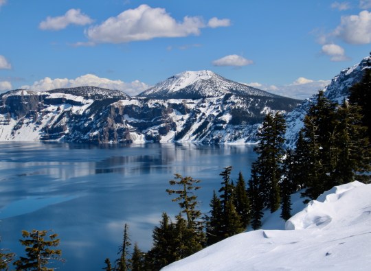
Crater Lake National Park is renowned for its beauty and the deep blue color of its water. It has an icy blue look here. Peggy took this photo from the Rim Village. Scott Mountain dominates in the distance. (Photo by Peggy Mekemson.)
The massive, 12-mile-high Mt. Mazama blew its top 7000 years ago. Local Native American legend claims that it had gone to war with Mt. Shasta, a hundred miles to the south. Mazama lost. It wasn’t that the massive explosion used up all of its bullets, aka lava. The problem was that using the magma emptied out the large chamber beneath the mountain and the weight of the Mazama brought it crashing down into the empty chamber, leaving behind a large crater or caldera to use the technical term. The caldera filled with water and voila! Crater Lake was born.
A photo I took of Mt. Shasta. Had Mt. Mazuma survived its explosion of 7,000 years ago, it may have looked something like this.
Peggy and I visited the National Park a week ago. It’s about a 2 ½ hour drive from our house. We drove up by ourselves and were careful to keep the virus-safe distance from the relatively few other people who were visiting. One individual insisted on invading our space, however…
This fellow apparently thought sniffing my shoe was more important than maintaining the 6 feet recommended to avoid coronavirus. “What are you thinking, guy?” I asked. “It’s a girl,” Peggy informed me. “She’s wearing pink.”
We had visited Crater Lake twice last summer and were eager to see it in the winter covered with snow. We were really glad we did. For one, it was as beautiful as we had expected it would be— and, two, the park closed on Tuesday because of coronavirus. The odds are that it will be closed until long after the snow melts. Here’s a map and some of the photos that Peggy and I took.
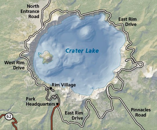
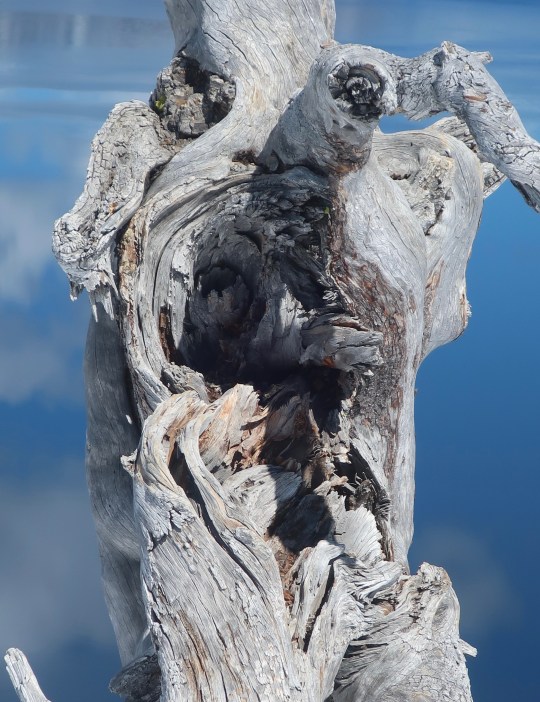
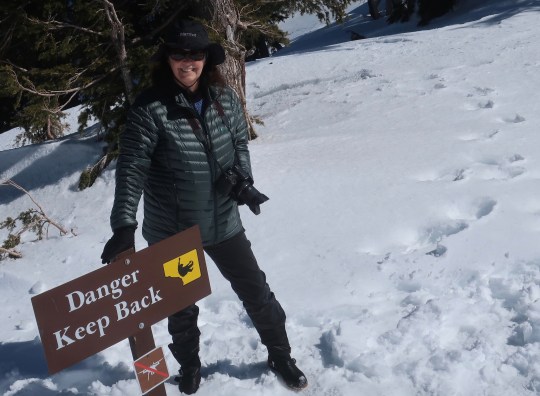
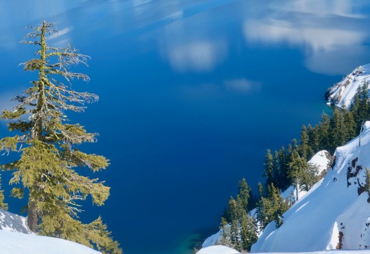
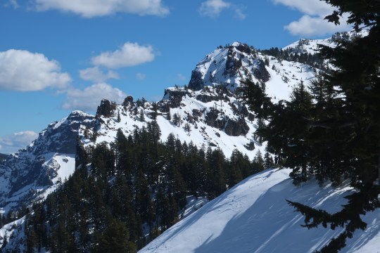
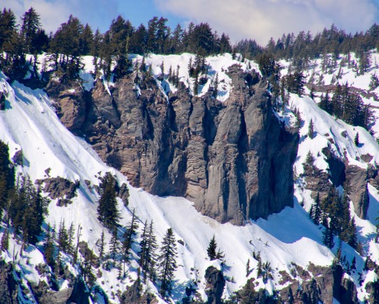
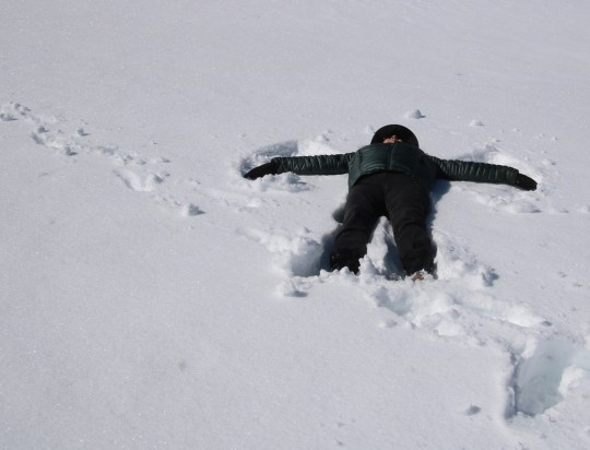
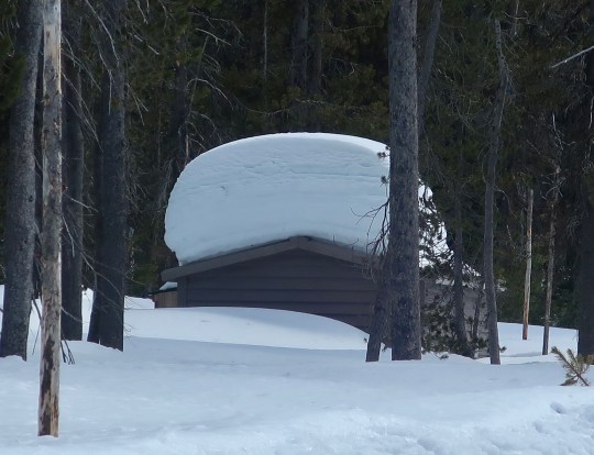
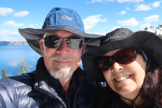
This National Park map provides an overview of the lake. Peggy and I were at Rim Village. The road around the lake is closed in winter and doesn’t open again until sometime in the summer. Wizard Mountain is on the left. The sheer cliffs around the lake are obvious. The lake is 1978 feet deep at its deepest spot. It is 6.2 by 4.5 miles across.I’ve never met a tree stump I didn’t want to photograph. Let me put this one into perspective…Wizard Island provided a backdrop. Llao Rock, named after the Klamath Indian god of the underworld rears up behind the island. The deep blue water reflects both Wizard Island and the clouds above the lake.A close up of Wizard Island. It is actually a small volcano that rose up from the lake’s floor. You can visit it by boat if you are willing to walk the thousand feet to the water. Afterwards, you get to hike the thousand feet back up. (Photo by Peggy Mekemson.)Other than the one trail, it’s a long way to fall to get to the lake and there are plenty of signs to warn you. The smaller sign forbids the use of drones.This photo gives a perspective on the steep drop.The cliffs as seen looking across the lake. I liked the impressionist-like reflection. (Photo by Peggy Mekemson.)Impressive rock formations surround Crater Lake. This one is located south of the Rim Village. I believe it is Garfield Peak.These were on the opposite side of the lake above Wizard Island. (Photo by Peggy Mekemson.)This is the trail that took us from the parking lot into the Rim Village overlook. (Photo by Peggy Mekemson.)Peggy points out the depth of the snow.This photo of two of the buildings at the Crater Lake Rim Village also provide a look at the depth of the snow. The trail leads over to the lakes rim. I rendered the photo in black and white. Peggy captured two fun photos of the roof. (Photo by Peggy Mekemson.)And the left edge of the building. (Photo by Peggy Mekemson.)All of the snow demanded a snow angel and I volunteered Peggy.It came out three dimensional! Peggy thought it was a bit spooky. Something took a big chunk out of her side. (It was from her knee getting up.)As always, we wandered around taking random photos. One of mine included this tree with its bone-colored limbs.Peggy caught these backpackers on snowshoes.Speaking of backpackers, the Pacific Crest Trail runs through the park. We didn’t see any through hikers, which wasn’t surprising. This is the restroom at the trailhead! Peggy and I will likely backpack through the park starting here this coming summer.I’ll conclude today’s post with a selfie of Peggy and me at the Lake’s edge— our last visit before lockdown. 🙂
46 thoughts on “We Visited Crater Lake National Park Last Week… Just Before It Closed”
It is such a beautiful place Curt. You brought back my first visit when, as an Easterner, I was amazed at driving up to the lake through high walls of snow! And it was June!
Almost always good for snow up into July when the roads around the lake finally open up. I have a photo of my father up there in 1939… Same high snow. It has a unique beauty all of its own, Ray. –Curt
Can’t believe that during our one visit to Oregon we didn’t go on down to Crater Lake. Thanks for showing me what we missed, and now I need to figure out a way to get there. My fave photo is the reflection one. Kudos.
You missed a beauty, Rusha. Peggy and I have been kicking ourselves that we don’t get there more often since it is an easy day trip and the trip itself is quite beautiful! –Curt
Have to wait now, sigh. The park has been closed now at the request of the state. Still, when it is opened again, it just a few hours from Sacramento. From Medford to Sacto is almost a commute route for us… just not now. Be safe. –Curt
Six plus hours in good weather and on the way to see family one of these days. Yah everything is on lockdown. It’s gonna be a long spring.
I bought 40 pounds of birdseed so the birds would continue to visit and provide entertainment. 🙂
That’s nice. We used to put out birdseed regularly but it attracted rats like crazy. I miss it.
Our rats here are squirrels. 🙂
Great set of pictures Curt. I especially like the tree stump!
Everywhere closed here, I wonder if I get a refund on my National Trust membership?
Don’t know about that, Andrew, but the cruise line has given us a partial payment back and the rest in credit for another trip. I thought it was interesting that the US bailout doesn’t include cruise lines. The reason: they all register overseas to avoid paying American taxes. I feel for the cruise lines but there is a bit of karma at work here.
I have paid a deposit but won’t pay the balance when it is due so will have to see if I can get a refund. Oh well, easy come, easy go!
As always my imagination runs wild with what the rock formations and bare trees look like to me. You both took some terrific photos here.
Thanks, G. We were there a couple of times over the summer and had a lot more photos but they were done in by the internet in some strange way. Sigh. First photos that I have ever lost. –Curt
So glad we made it before the state closed it down. As for that gnarled face, I figured it could scare the corona virus out of someone. In fact that gives me an idea for post.! –Curt
Glad you did not try and hike towards the edge of the lake. Amazing that a sign to not use drones was felt necessary. Can’t people enjoy the sight from a normal human height.?
Great photos,
The closer you get to the edge, Gerard, the more obvious it becomes! Still, in the summer, we watched people standing on the edge taking selfies, like the Grand Canyon. Not smart.
You’d think people could enjoy the sight just fine. It is incredible! But the drone business is pretty crazy. Their hobby tends to distract from the beauty for everyone else.
Thanks! –Curt
A gorgeous place in summer and winter!
As for when we will be able to get out and wander again, or even go to a movie, who knows, Dave. We won’t be totally clear until a vaccine is developed. As for now, we will be heading to town only for necessities and making it in and out as quickly, and safely as possible. Stay well. –Curt
We were lucky. Did it something on a whim.
Tourist business is always a conundrum, Gunta, it seems to me: needed for the economy but something of a bother for locals. –Curt
Despite all the years I’ve been in Oregon I’ve only been there twice – most recently about 30 years ago. My wife has never seen it. Can you say, overdue?
What a beautiful, crisp day you had! The photos are all great (loved the restroom, too, even though the nature shots are the ones I meant!), and I really adore the overview map (I’m a map gal).
We lucked out with the weather, Lexi. Actually I watched the forecasts carefully. Crater lake isn’t the best place to drive in a snowstorm!
I should incorporate more maps. I’m with you on that one. I have hundreds. 🙂 Thanks. –Curt
Wow! Amazing to see it with all the snow. We were there a few years ago in August. I thought it closed down over winter but obviously not! Thanks for sharing!


It is such a beautiful place Curt. You brought back my first visit when, as an Easterner, I was amazed at driving up to the lake through high walls of snow! And it was June!
Almost always good for snow up into July when the roads around the lake finally open up. I have a photo of my father up there in 1939… Same high snow. It has a unique beauty all of its own, Ray. –Curt
Hoping to travel many more virtual miles following your journey Curt.
Regards Thom
Glad to have you along, Thom! –Curt
Can’t believe that during our one visit to Oregon we didn’t go on down to Crater Lake. Thanks for showing me what we missed, and now I need to figure out a way to get there. My fave photo is the reflection one. Kudos.
You missed a beauty, Rusha. Peggy and I have been kicking ourselves that we don’t get there more often since it is an easy day trip and the trip itself is quite beautiful! –Curt
Water doesn’t get much bluer than that!
A thousand feet deep and quite pure!
I regret I’ve never been!
Have to wait now, sigh. The park has been closed now at the request of the state. Still, when it is opened again, it just a few hours from Sacramento. From Medford to Sacto is almost a commute route for us… just not now. Be safe. –Curt
Six plus hours in good weather and on the way to see family one of these days. Yah everything is on lockdown. It’s gonna be a long spring.
I bought 40 pounds of birdseed so the birds would continue to visit and provide entertainment. 🙂
That’s nice. We used to put out birdseed regularly but it attracted rats like crazy. I miss it.
Our rats here are squirrels. 🙂
Great set of pictures Curt. I especially like the tree stump!
Thanks, Andrew. It was a beautiful day and we were lucky to get up there before the area was closed down! –Curt
Everywhere closed here, I wonder if I get a refund on my National Trust membership?
Don’t know about that, Andrew, but the cruise line has given us a partial payment back and the rest in credit for another trip. I thought it was interesting that the US bailout doesn’t include cruise lines. The reason: they all register overseas to avoid paying American taxes. I feel for the cruise lines but there is a bit of karma at work here.
I have paid a deposit but won’t pay the balance when it is due so will have to see if I can get a refund. Oh well, easy come, easy go!
As always my imagination runs wild with what the rock formations and bare trees look like to me. You both took some terrific photos here.
Thanks, G. We were there a couple of times over the summer and had a lot more photos but they were done in by the internet in some strange way. Sigh. First photos that I have ever lost. –Curt
Strange things go on within the internet – some people blame China or Russia – I blame everything on sun spots… 😎
Yeah, at this point, we need more action than blame. I’m pretty sure history will take care of that. 🙂 –Curt
🤣
Nice selfie! You two are adorable — great partners in life and adventure. Enjoy the weekend!
Ha. Thanks Kelly. That’s sweet. –Curt
Glad you had a memorable outing. Now stay safe.
We aren’t budging unless it’s critical Peggy. You too. –Curt
Well that looks like a fun outing in gorgeous scenery. That’s quite the gnarled old face in the tree stump.
Alison
So glad we made it before the state closed it down. As for that gnarled face, I figured it could scare the corona virus out of someone. In fact that gives me an idea for post.! –Curt
Glad you did not try and hike towards the edge of the lake. Amazing that a sign to not use drones was felt necessary. Can’t people enjoy the sight from a normal human height.?
Great photos,
The closer you get to the edge, Gerard, the more obvious it becomes! Still, in the summer, we watched people standing on the edge taking selfies, like the Grand Canyon. Not smart.
You’d think people could enjoy the sight just fine. It is incredible! But the drone business is pretty crazy. Their hobby tends to distract from the beauty for everyone else.
Thanks! –Curt
A real winter wonderland! Let’s hope it’s not too long before you (and, of course, all of us) are able to get out and about again!
A gorgeous place in summer and winter!
As for when we will be able to get out and wander again, or even go to a movie, who knows, Dave. We won’t be totally clear until a vaccine is developed. As for now, we will be heading to town only for necessities and making it in and out as quickly, and safely as possible. Stay well. –Curt
Thanks, Curt, you too! And let’s raise a glass to the resumption of ordinary life for us all!
Yes, before we grow old (older). 🙂
How wonderful you had this adventure before sheltering in place…
It’s obvious businesses here are suffering because the tourists have noticeably decreased, but it’s rather nice to have things so quiet.
We were lucky. Did it something on a whim.
Tourist business is always a conundrum, Gunta, it seems to me: needed for the economy but something of a bother for locals. –Curt
Despite all the years I’ve been in Oregon I’ve only been there twice – most recently about 30 years ago. My wife has never seen it. Can you say, overdue?
What a beautiful, crisp day you had! The photos are all great (loved the restroom, too, even though the nature shots are the ones I meant!), and I really adore the overview map (I’m a map gal).
We lucked out with the weather, Lexi. Actually I watched the forecasts carefully. Crater lake isn’t the best place to drive in a snowstorm!
I should incorporate more maps. I’m with you on that one. I have hundreds. 🙂 Thanks. –Curt
Stunning!
It is beautiful…
Wow! Amazing to see it with all the snow. We were there a few years ago in August. I thought it closed down over winter but obviously not! Thanks for sharing!
Impeccable timing and so good to catch it before the big melt.
Yes on both counts! 🙂