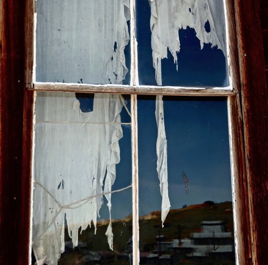
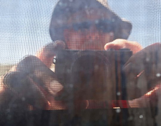
What better way to introduce the ghost town of Bodie than with a ghostly, tattered curtain. The Standard Mining Company mill can be seen in the reflection.
The history of the gold and silver strikes in the Old West of the mid 1800s is one of boom and bust. Large towns of several thousand people would spring up overnight in remote locations and be abandoned almost as fast as veins ran out and other strikes fired the imagination of miners driven by dreams of instant wealth.
Some of the towns have lingered on into modern times. Diamond Springs, where I grew up in the heart of California’s gold country, is one. A 25-pound gold nugget found nearby in the early 1850s assured Diamond of its boomtown status. It was a sleepy, ‘one-horse-town,’ in my youth. Today, it is more like a sprawling suburb. Virginia City, Nevada, which we will visit next on my Highway 395 series, not only survived but worked to maintain its historical look and has become a successful tourist attraction.
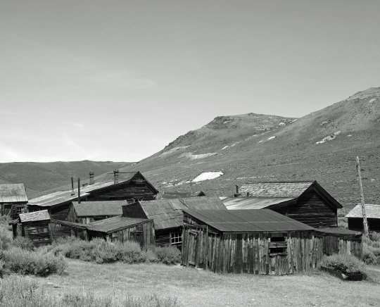
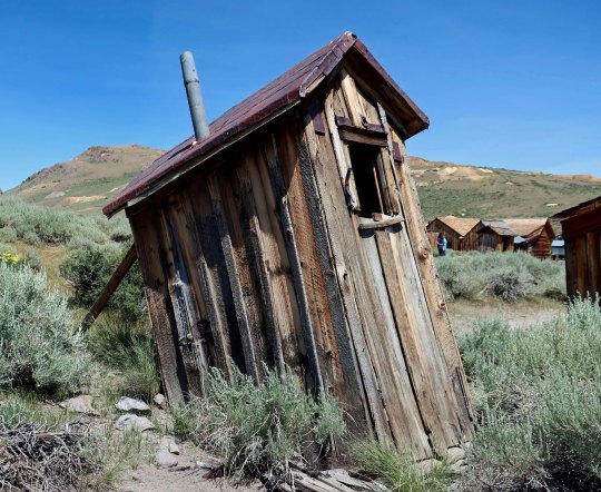
Bodie is another tourist attraction. It has survived as a ghost town, however— in arrested decay as the California State Park staff describes it. Only three people were living there in 1943, the year I was born. That number had plummeted to zero by 1950. (Plummeted being relative, of course.) Gold was first found in 1859 but it was in 1876 when the Standard Company found a profitable gold vein that turned the small camp of a few hard-core miners into a rollicking boomtown of 5-7 thousand people with over 2000 buildings. Sixty-five saloons dominated its mile-long main street. I have learned over the years that the number of saloons is always a mark of pride for Old West towns. (A substantial red-light district is another.)
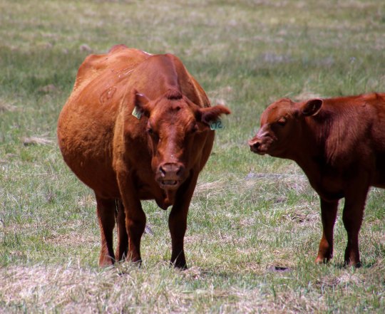
Bodie was named a National Historic Landmark in 1961and a California State Historical Park in 1962. Today, just over a hundred of its original two thousand buildings remain. I arrived around 1:00 p.m. on my drive down Highway 395 and spent three rather warm hours wandering around checking out the buildings and other historical remnants left behind— and dodging fresh cow pies. There were so many tourists it was hard to get photos without them. But who wants photos of tourists in a ghost town?! I did photograph the free-range cattle, however. Now if only a ghost or two had made an appearance…
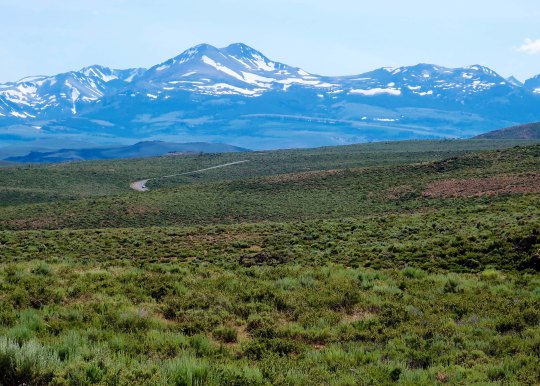
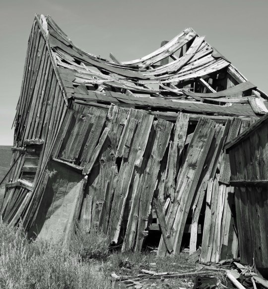
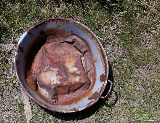
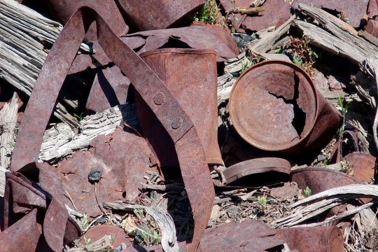
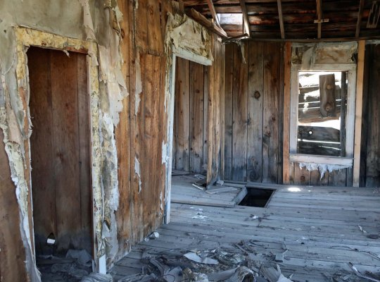
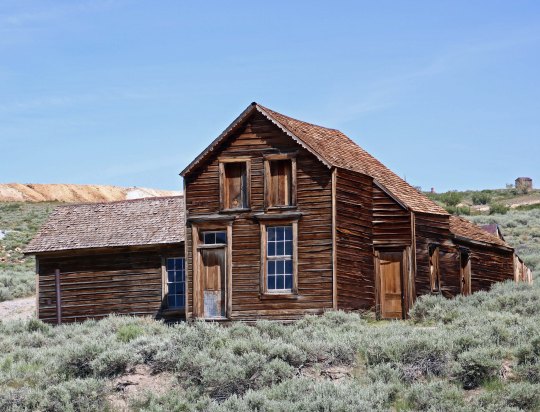
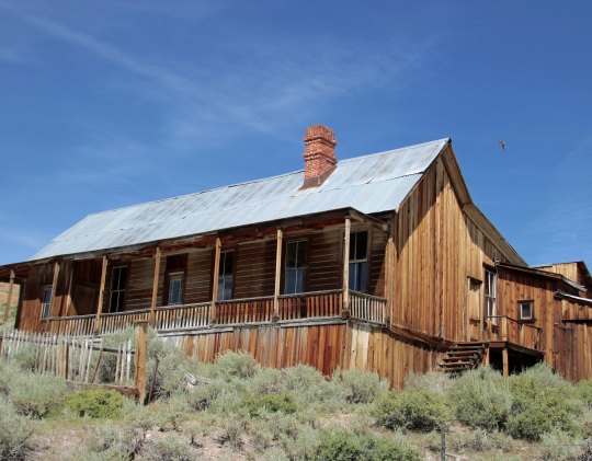
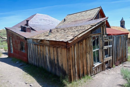
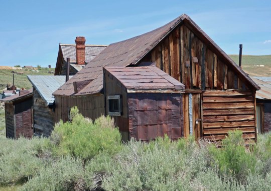
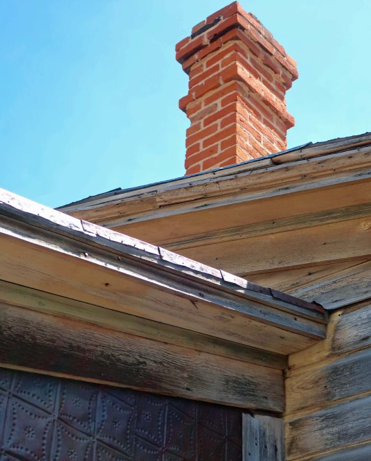
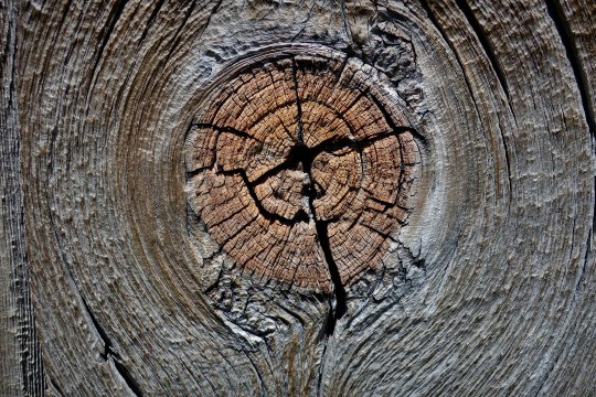
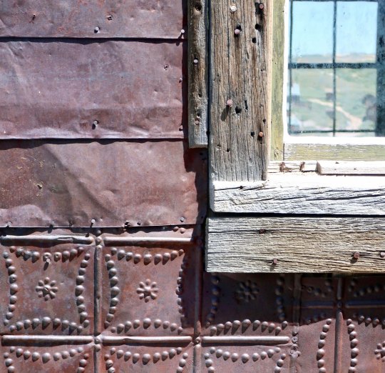
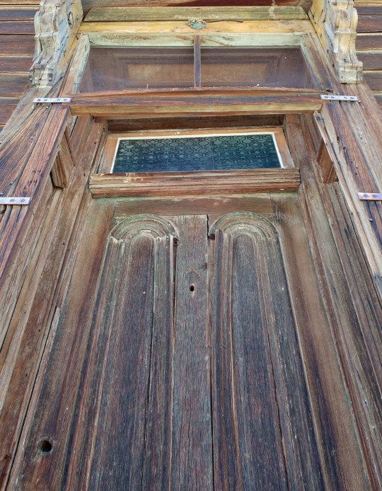
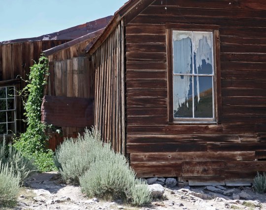
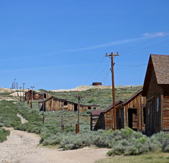
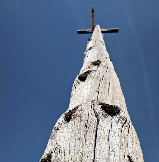
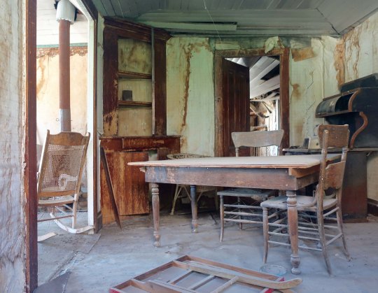
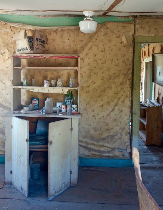
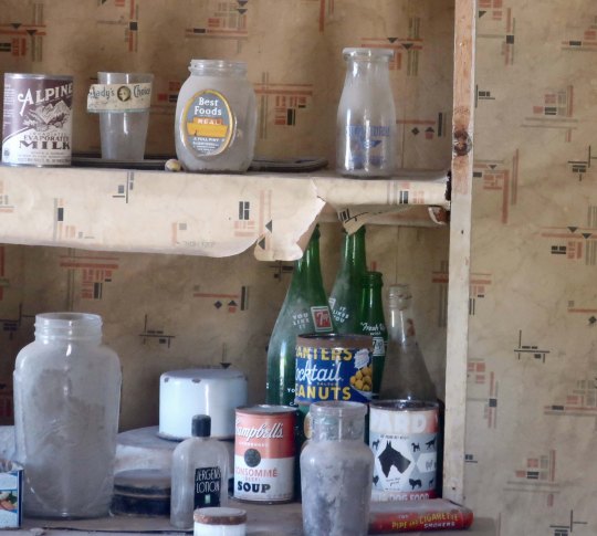
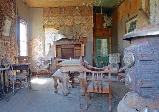
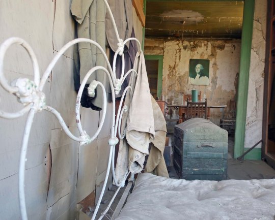
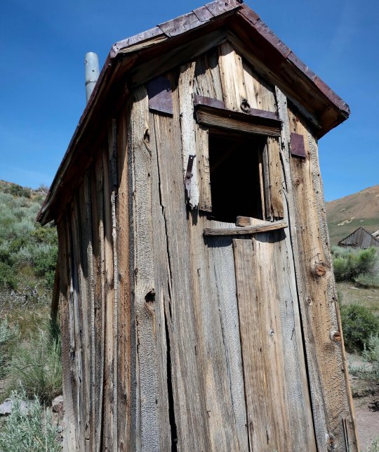
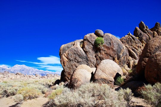
One big Mama and her calf. Free range cattle wander around Bodie like it belongs to them, leaving presents on the ground for tourists.It isn’t that the cattle don’t have other country to roam in. Those are the Sierra Nevada Mountains in the distance. You can see a portion of the 13 mile road coming in to Bodie from Highway 395. The last three miles are dirt. Quivera, our small RV, whined about the wash board road the whole way.My idea of what a ghost town should look like! Not much in the way of ‘arrested decay’ here.The buildings the shack is attached to are more typical of what you find in Bodie, however. Sagebrush is the dominant plant, which speaks to Bodie’s desert environment. Mine tailings can be seen on the distant hills.This house looked almost livable from the outside until you got up close.A blue wash basin was sitting on the ground out front.And a small garbage dump found nearby.It’s looking inside houses that gives you the true feeling of being in a ghost town. Visitors are invited to be ‘peeping toms.’ Most houses look better than this.Here are a few homes to give you an idea of the houses that remain in Bodie.I was fascinated with the roof lines of the houses.And check out the red brick chimney!Weathered wood covers most of the cabins. My camera was attracted to this knot. Once upon a time it would have been a happy limb.Several of the residents had used metal as well as wood to cover their homes.One house had a rather fancy door.Here’s the window with the ghost curtain featured at the top of the post. I think that is a honeysuckle vine on the left.A street view in Bodie shows houses heading up the hill. The power poles are modern.Here’s my choice for a ghost town power pole.Now, let’s take a look inside some of the Bodie homes.You would call the call the cops if you looked out your window and saw this!Some even featured groceries left behind. This one had me checking Google to see if they were around in the 30s. They appeared legit!Best Foods Mayonaise, Planters Peanuts, Campbell Soup and Pard dog food were all around.A pot bellied stove! It gets cold in Bodie during the winter. And check out the dining table.A bed, clothing, a trunk and a print of Gilbert Stuart’s famous painting of George Washington. Stuart painted this for Martha Washington but decided he wanted to keep it and use it for marketing purposes, so he left it unfinished. The painting would become the model for Washington on the dollar bill.Outhouses were common in Bodie. This one came with a view!It could be a little risky using it now, however… Propping up is part of the ‘arrested decay’ program.
NEXT POST: We will continue our exploration of Bodie by checking out some of the commercial buildings that still stand including a ghostly old mortuary with caskets. There are also several abandoned vehicles in various states of decay and some interesting mining machinery left behind.
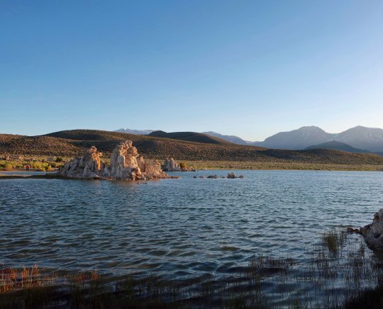
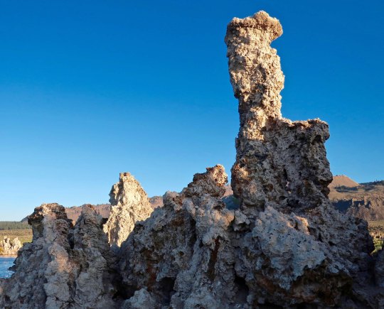
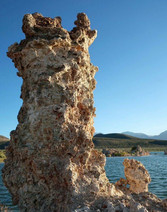
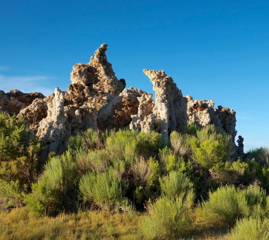
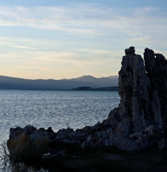
It’s hard to believe that springs bubbling up beneath the surface of Mono Lake were able to create sculptures like the tufa towers you find at Mono Lake.
You’re stuck if you are a raindrop falling into Mono Lake— or anywhere else in the Great Basin. There are no convenient rivers to whisk you away to the sea. Evaporation is your only escape. Water tends to become a little grouchy under these conditions, or make that salty. In fact, Mono Lake is 2.5 times as salty as the ocean, and 100 times as alkaline. The good news here is it is really hard to drown. You can float to your heart’s content. Even sea gulls have a hard time keeping their feet in the water to paddle. The bad news is a minor cut or scrape will send you screaming for the shore.
There is magic in the water, however. Springs flowing underground from the surrounding mountains are rich in dissolved calcium. When they bubble up into the lake, the calcium bonds with the carbonates in the lake and together they make rocks, or what are known as tufa towers. In the past, when the lake was full, these towers hid out under the surface and happily continued to grow. There were few or no tufa towers to see. Mark Twain camped out on the lake in the 1860s when he was searching for a lost gold mine and noted in Roughing It,“This solemn, silent, sailess sea— this lonely tenant of the loneliest spot on the earth—is little graced with the picturesque.”
Obviously, the tufa towers weren’t there to greet him. We can thank Los Angeles’s formidable Department of Power and Water for their presence. Back about 1913, DPW had the challenge of supplying more water to the ever-thirsty Los Angeles with its desert environment and burgeoning population. It decided that there was plenty of water up in Owens Valley along the eastern side of Sierras. DPW didn’t bother to ask the local residents, farmers and ranchers whether they wanted their water to go to LA. It didn’t have to. It had the power to grab what it wanted. Things got nasty. Water wars in the West aren’t pretty. “Greed of City Ruins the Owens Valley” the headlines in the Inyo Register screamed. And it wasn’t far from wrong. Every stream of consequence flowing into the valley was tapped to meet LA’s water needs. What lakes that existed started drying up, including Mono Lake. Starting in 1941, DPW began taking water from the lake’s major tributaries, dropping the lake some 40 feet.
Building the pipeline that the LA DPW used to transport water from Owens Valley to LA.Another perspective on the size of the pipeline.Yes, this is me standing in a segment of the pipeline. And no, I wasn’t around when the pipeline was being built.
Environmentalists mounted a major effort starting in the 70s to save the lake. Fish can’t survive in the highly saline/alkaline water, but some four trillion brine shrimp, innumerable small alkali flies, and algae find the conditions perfect. The shrimp and flies, in turn, serve as a major food source for the two million birds that stop off to dine in the lake. The lowering water levels threatened to kill off the algae, shrimp and flies. The birds were in danger of losing their handy fast food restaurant. In 1994, The California Department of Water Resources stepped in to resolve the issue by requiring DPW to reduce the amount of water it was taking from the lake’s streams and repair some of the damage it had done to the riparian habitats along the streams. While the lake won’t return to the levels that existed when Mark Twain visited, the ecosystem is now being protected. Birds will be able to continue to stuff themselves while visitors can continue to enjoy the unique beauty of the tufa towers.
This handsome fellow is a male brine shrimp featured on a signboard at Mono Lake. Length would be about thumbnail size.This provides an idea of how many alkali flies live around the lake.I took this close up as further proof. The flies spend much of their life under water as eggs and pupae. When the adults dive under the water to feed and lay eggs, they travel with a bubble of water. Think scuba diver. Local Native Americans considered the fly eggs to be a delicacy. While I missed the height of bird migration, large flocks were still flying in formation and feeding on the water’s surface.Wilson’s Phalarope stop off at Mono Lake in the midst of a long journey. Mom arrives first in June, leaving Pop at home to finish raising the babies. Pop and kids start arriving later in June and through July raising the total population to around 100,000. The birds are around for 4-6 weeks while they molt and pig out on brine shrimp and alkali flies, doubling in weight. The extra weight is critical for the next segment of their journey: a 3,000-mile nonstop flight to Ecuador.
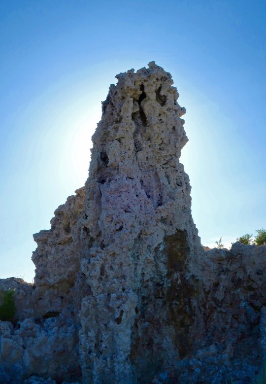
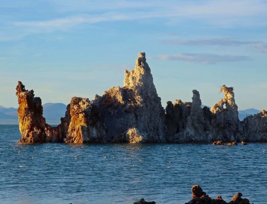
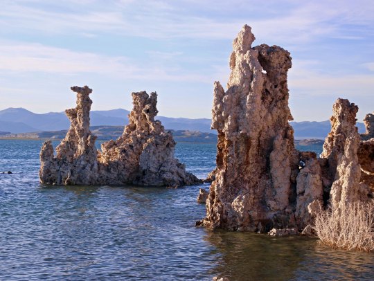
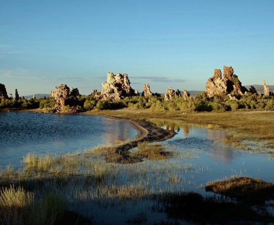
It was late in the afternoon when I visited the south end of the lake where the most impressive tufa towers are found so I was able to photograph the towers at sunset. The warm tones added to the beauty. I took lots of pictures. (Grin) To get here look for the signs that direct you to the South Tufa Towers south of Lee Vining off of Highway 395.
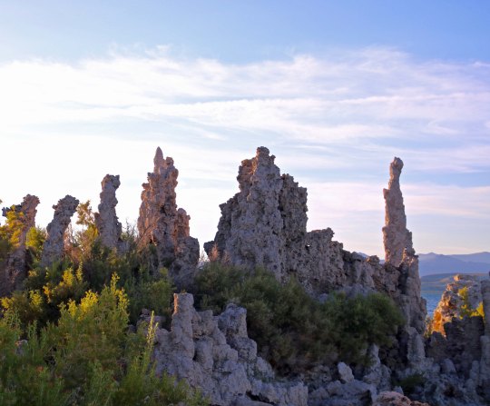
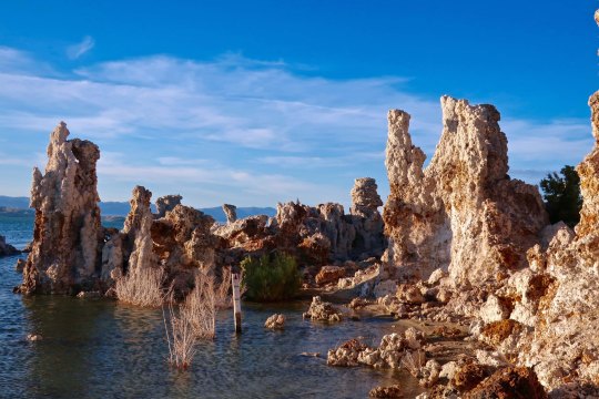
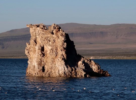
To provide perspective, these are the tufa towers on Mono Lake with the Sierra Nevada mountains in the background. Even without the towers I have a hard time imagining why Twain found the area “little graced with the picturesque.”I divided my photos of the tufa towers into three categories for organization. First up was individual sculptures as shown below.Next, are groupings of the tufa towers.I will finish this series with several photos that place the tufa towers in their broader environment but first I wanted to show this picture I took from the north end of the lake looking south. This would have been more like how Mark Twain saw the lake.I was enamored with this side channel in different light.And took photos from both directions. Here, I caught a sea gull landing.A final view as the sun slipped behind the Sierra Nevada Mountains.
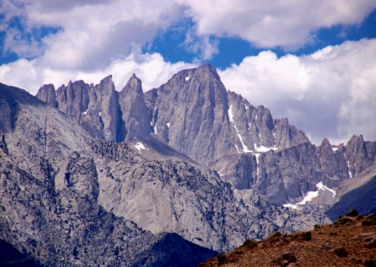
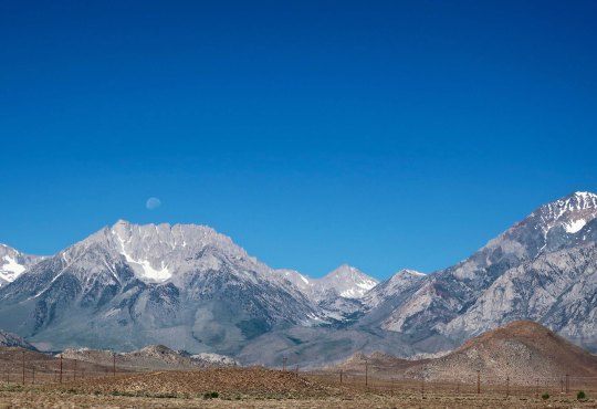
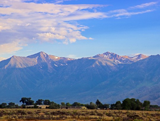
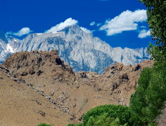
What better place to start a drive up Highway 395 with its stunning views of the Sierra Nevada Mountain Range than Mt. Whitney. I’ve already included some photos of this beauty in on my Alabama Hills’ post. Maybe even this one.
There is a lot to see along California’s Highway 395, and I am bringing much of it to you in this series. We’ve already visited the Alabama Hills with its fascinating relationship with Hollywood. In my last post, I took you to the World War II Japanese internment camp of Manzanar with its tragic history and relevance for our modern world. You have patiently made your way through lots of words! Thank you. It’s time for another photo blog, heavy on pictures and light on verbiage. (grin) What better opportunity than admiring the views of John Muir’s Range of Light: the Sierra Nevada Mountains. It’s one of my major reasons for visiting the area. These are some of my favorite photos from the trip.
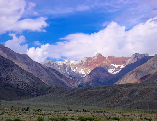
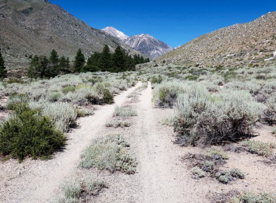
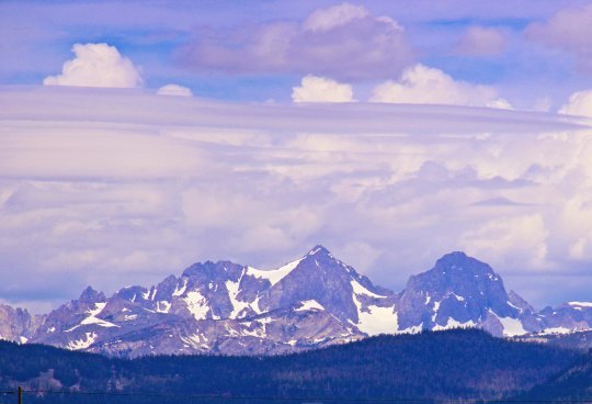
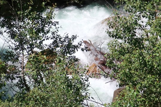
Ansel Adams added to the fame of the Sierra’s with his magnificent black and white photos. Ansel Adams I am not, but I still can’t resist rendering some of my Sierra photos in black and white, taking a step back in time. I thought that the power poles caught in the sunlight added a nice touch.This illustration provides a perspective on how the Sierras were created. The Sierras are a fault block range with the mountain rising along a fault while the valley sinks. It’s a process that continues today. Think of all the earthquakes in the area. This process also means that the mountains are steeper on the east side than they are on the west— a fact I know well having started many a backpack trip from the east! “Okay, legs, we are going to start this morning with a 3,000 foot climb.”Views like this seriously detract from paying attention to the traffic on Highway 395! Fortunately, a number of pullouts allow you to stop and enjoy the scenes.Sometimes the view is more like a glimpse. The clouds provided drama.The view called for another black and white rendition. Which photo do you prefer?The moon caught my attention here.Out came the telephoto for a closer look. Much of the Sierras’ rugged beauty is due to glaciers carving out the granite.Thunderstorms and showers are common to the High Sierras of the southern part of range. The Sierras increase in altitude as you go south, peaking out at Mt. Whitney.Here they turn dark. The thunder and lightning shows can be quite impressive when up in the center of the storms, and sometimes downright scary. I’ve hurried off more than one high pass. For the more adventuresome, a number of inviting roads lead off into the mountains. Most cars could easily travel over this road, assuming you don’t mind a few bumps and dust along the way.Other roads require a little more thought: Quivera, our small RV, said no on this one. Note how dry it is here. The western slopes of the Sierra Nevada Mountains pull most of the rain out of the clouds, so the eastern slopes are desert like.The snows were heavy in the Sierras last winter and were slow to melt off this summer. This is a lot for August. One result is that the creeks and rivers can look like this with snow melt. It isn’t something a backpacker could or would cross. Often there are downed logs across these torrents. As you can imagine, it’s a nervous crossing. The narrower the log, the more nervous!If you are a skier, especially from Southern California, this mountain might look familiar. It’s Mammoth Mountain. You can see the ski runs on the lower slopes.I close today with this final view of the Sierras from Carson Valley. At this time last year, I was backpacking down the PCT through these mountains.
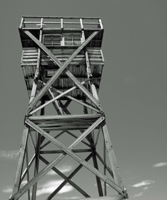
Several guard towers like this surrounded the Japanese American relocation camp at Manzanar during World War II. Had I been an American citizen of Japanese descent instead of British descent, it’s likely that I would have been born in one of the West Coast relocation centers surrounded by barbed wire.
The World War II Japanese ‘relocation center’ of Manzanar is located a short ten miles north of Lone Pine and the Alabama Hills just off of Highway 395. I went there directly from the Lone Pine Museum of Film History. It would be hard to find two more different reminders of our past. As far as I can remember, I didn’t know about the site until I was in college. It wasn’t something that was discussed at my home. Had I been an American citizen with Japanese ancestry as opposed to British ancestry, it’s likely that I would have been born at one of the West Coast “relocation centers,” i.e. concentration camps, behind barbed wire fences overlooked by guard towers bristling with guns.
I may have learned about the camps in high school during American History but it was made real for me at the community college I attended just east of Sacramento in 1961-63. I was student body president in 1962 and a member of my council was a young Japanese American woman who had experienced the relocation effort directly. Her family, along with several other Japanese American farmers in the Loomis/Lincoln area, were rounded up, forced to abandon their farms, and shipped out to Tule Lake where the relocation center for most of Northern California was located.
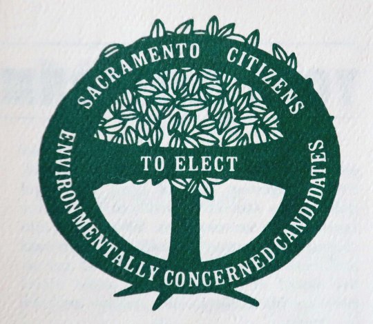
Ten years later in the early 70s, I would come to know another Japanese American who had been shipped along with his family to Tule Lake as a six-month old child, Bob Matsui. In 1971, working together with other environmentalists, I had created a political organization in Sacramento to elect environmentally concerned candidates to the Sacramento City Council and Board of Supervisors. Bob, who was making his first run for city council, had scored high on a questionnaire that we had put together. I had enthusiastically supported him in his run for election and he had won. Not only did he support environmental issues on the City Council for seven years, he continued to in 1978 when he became the fifth Japanese American to be elected to Congress. He would serve with distinction for a quarter of a century and be known for his bipartisan approach in creating substantive legislation.
More to the point of this post, Bob also became a strong advocate for recognizing the wrongs that had been done to Japanese Americans during World War II. For one, he was instrumental in having Manzanar set aside as a National Historic Landmark. In 1980 he joined Senator Daniel Inouye, and Congressmen Spark Matsunaga and Noman Mineta, in an effort to establish a committee to study the effects of the incarceration and the potential for redress.The end result of this effort was the creation of the Commission on Wartime Relocation and Internment of Civilians. After an extensive set of hearings throughout the West, the bipartisan Commission concluded that the decision to incarcerate the Japanese Americans was not based on military necessity and instead was based upon “race prejudice, war hysteria, and a failure of political leadership.” Not one Japanese American was found guilty of aiding Japan during World War II.
The findings of the Commission led to the Civil Liberties Act of 1988 which granted wartime survivors an apology and individual reparations of $20,000. While President Reagan initially opposed the implementation legislation, H.R. 422, because of cost, he readily signed the bill when it reached his desk. I found his comments at the signing ceremony to be quite relevant, not only to the legislation, but for today.
He had started the ceremony by noting “… we gather here today to right a grave wrong. More than 40 years ago, shortly after the bombing of Pearl Harbor, 120,000 persons of Japanese ancestry living in the United States were forcibly removed from their homes and placed in makeshift internment camps. This action was taken without trial, without jury. It was based solely on race, for these 120,000 were Americans of Japanese descent.”
Reagan went on to describe H.R. 442: “The legislation that I am about to sign provides for a restitution payment to each of the 60,000 surviving Japanese-Americans of the 120,000 who were relocated or detained. Yet no payment can make up for those lost years. So, what is most important in this bill has less to do with property than with honor. For here we admit a wrong; here we reaffirm our commitment as a nation to equal justice under the law.”
The President concluded his statements by reading a newspaper article from 1945 that had been included in the Pacific Citizen:
“Arriving by plane from Washington, General Joseph W. Stilwell pinned the Distinguished Service Cross on Mary Masuda in a simple ceremony on the porch of her small frame shack near Talbert, Orange County. She was one of the first Americans of Japanese ancestry to return from relocation centers to California’s farmlands. “Vinegar Joe” Stilwell was there that day to honor Kazuo Masuda, Mary’s brother. You see, while Mary and her parents were in an internment camp, Kazuo served as staff sergeant to the 442d Regimental Combat Team (an all Japanese-American regiment). In one action, Kazuo ordered his men back and advanced through heavy fire, hauling a mortar. For 12 hours, he engaged in a singlehanded barrage of Nazi positions. Several weeks later at Cassino, Kazuo staged another lone advance. This time it cost him his life.”
The newspaper clipping noted that her two surviving brothers were with Mary and her parents on the little porch that morning. These two brothers, like the heroic Kazuo, had served in the United States Army.
After General Stilwell made the award, the motion picture actress Louise Allbritton, a Texas girl, told how a Texas battalion had been saved by the 442d. Other show business personalities paid tribute — Robert Young, Will Rogers, Jr. And one young actor said: “Blood that has soaked into the sands of a beach is all of one color. America stands unique in the world: the only country not founded on race but on a way, an ideal. Not in spite of but because of our polyglot background, we have had all the strength in the world. That is the American way.” (Italics mine)
Reagan then went on to note with his usual sense of humor: “The name of that young actor — I hope I pronounce this right — was Ronald Reagan. And, yes, the ideal of liberty and justice for all — that is still the American way.”
Now that’s what being Presidential, the President of all Americans, is about. Following are several photos I took at Manzanar.
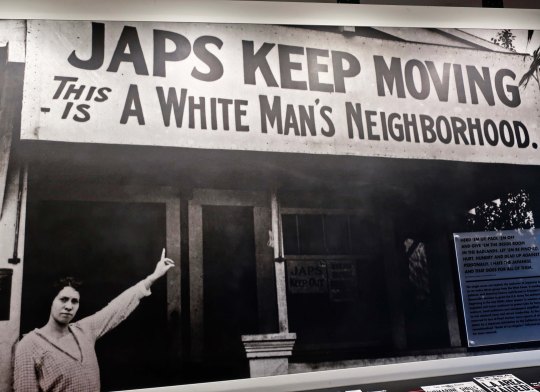
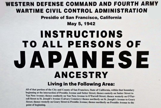
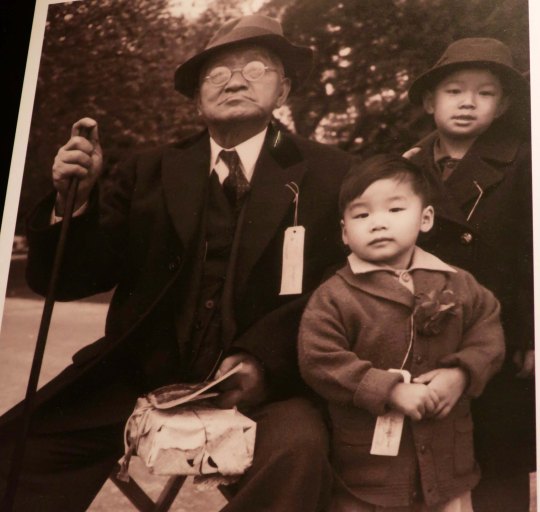
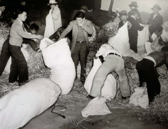
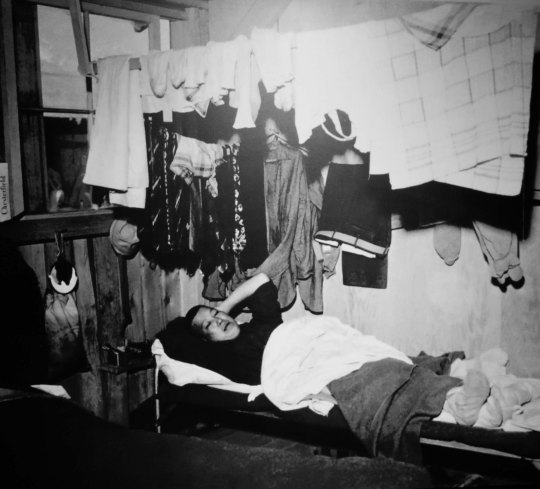
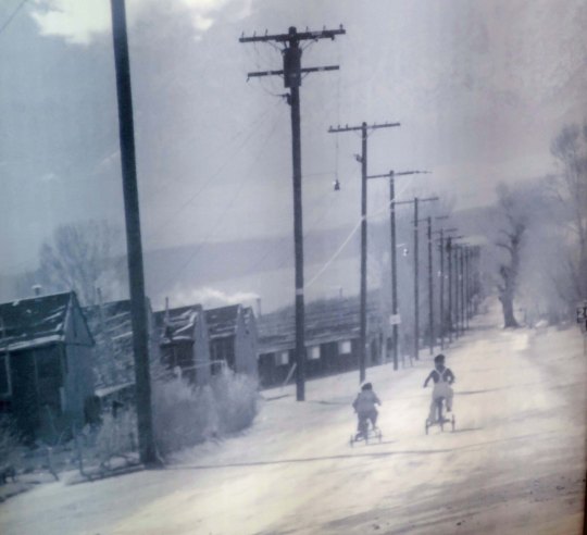
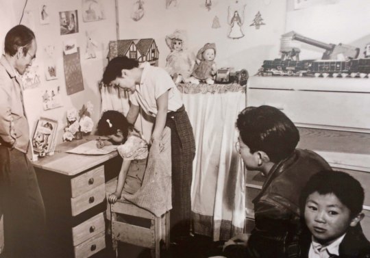
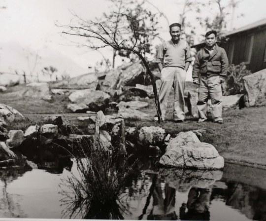
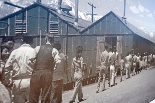
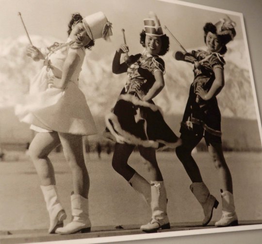
The bombing of Pearl Harbor naturally led to a fear of Japan, particularly on the West Coast. But it also released a deep prejudice against Japanese Americans that already existed. This large photo greets visitors to Manzanar.On May 5th, based on information provided by the Census Bureau, this sign went up wherever Japanese Americans were living on the West Coast. They were given two days to gather a few belongings and make whatever arrangements they could for their homes, businesses, etc. Note, the Census Bureau denied that it had provided the information up to 2007.This part of the poster informed Japanese-Americans what they could carry with them and when they were to report. They were more or less limited to what they could carry.A child sitting among some of the personal luggage.Each person was assigned a number. I couldn’t help but think of the numbers that were tattooed on Jews when they entered German concentration camps. One good point was that families weren’t separated. Children were allowed to remain with their parents.Upon arrival, prisoners were required to fill their own straw mattresses.This model provides a perspective on what the camp looked like. Over 10,000 Japanese Americans were crowded into 504 barracks which were divided into blocks with 14 barracks to a block. Barracks were divided into four rooms with each room holding eight people. Each block provided shared bathrooms, showers, a laundry, and a mess hall. Privacy was extremely limited. Both inside and out.Home sweet home.Several barracks have been recreated to provide a sense of what life would have been like. This was the women’s bathroom. You can imagine how hard it would have to get used to, especially if you were a private person. And think of yourself having a bad case of diarrhea. Children on tricycles make their way down a road.In spite of the hardships, and the fact that your were locked up behind barbed wire fences guarded by soldiers with weapons, the Japanese Americans did what they could to make their life tolerable. This family was large enough to have its own section of a barrack and had done what they could to turn it into home.A toy loan center was created so all children would have toys to play with.The barren landscape was turned into farms and parks. These gardeners had a nursery that they had turned over to the Veterans’ Administration when they were incarcerated. (How un-American is that?) In Manzanar, they built park-like gardens.Block residents line up for a meal at the mess hall. I was impressed with how they were dressed. Note the Sierras looming in the background.But can you trust a skinny cook?Tuesday nights were humorously named slop-suey night. I read in one place where residents sought out mess halls with the best cooks. This photo on cloth was in the recreated mess hall barracks. You could see the lights behind it. I thought it created an almost ghostly sense of the past at Manzanar.The mess halls also served as block meeting rooms and social centers. I was amused to learn that one of the most popular songs at the dances was “Don’t Fence Me In” by the Andrew Sisters. The words are below. Another observation here: Nothing stops young love. One of the most popular wedding gifts was nails and boards so young couple could create privacy for themselves.
“Oh, give me land, lots of land under starry skies above. Don’t fence me in. Let me ride through the wide open country that I love. Don’t fence me in. Let me be by myself in the evenin’ breeze, And listen to the murmur of the cottonwood trees. Send me off forever but I ask you please, don’t fence me in”
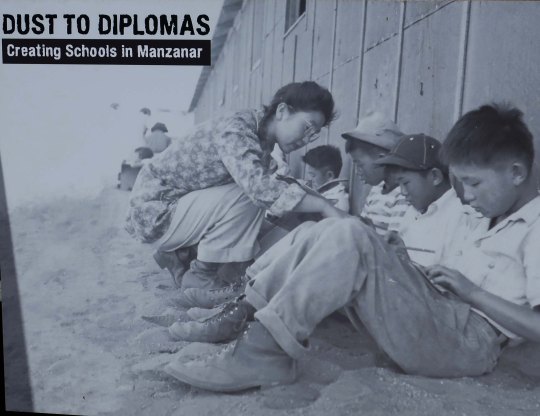
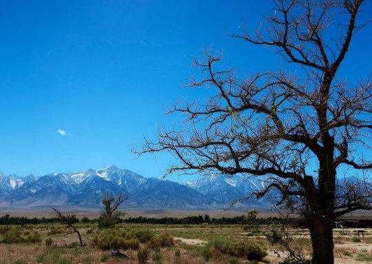
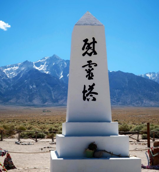
Education was extremely important to the Japanese Americans and they did everything they could to assure that their children went to school. Eventually, they would have regular classrooms.The Japanese Americans built this large hall for community wide meetings and events, such as graduation from high school. Today, it serves as the Visitors’ Center.I offer this last photo of Manzanar in the 40s. How much more American can you get?Today, Manzanar looks much like it did before the relocation center was built. The constant winds still blow and temperatures still climb to above 100 degrees F during the summer and below zero in the winter. This iconic monument to ‘console the souls of the dead’ with its dramatic Sierra Nevada backdrop is located in a small graveyard at the back of Manzanar. But, for me, it also serves as a memorial to the people who were rounded up and corralled here, to their heroic efforts to creat a bit of America in what was basically a concentration camp, and to the dark days in American history their confinement represents. Lest we forget.
NEXT POST: The number one reason for driving down Highway 395: Its dramatic mountain scenery.
John Wayne’s breakout movie where he moved from a B Level to an A Level actor was in the 1939 film, “Stagecoach,” part of which was filmed in the Alabama Hills. He had made 6 movies in the area before and would go on to make more afterwards.
When I arrived in Lone Pine, California, the first thing I did was go for a drive in the Alabama Hills located beneath the towering Sierra Nevada Mountains west of the town. I included photos of this adventure in my last post and noted that over 400 movies and several TV series had been filmed there. I was eager to see what Hollywood found so fascinating about this semi-remote location in the Eastern Sierras. The second thing I did was make a beeline to the Lone Pine Film History Museum to learn more about the movies and TV programs filmed in the area. Most of the photos in this post, I took in the museum. My own fascination with the Alabama Hills started early in my life. I just didn’t know it.
Tonto, Silver and the Lone Ranger.
I was excited. Alan Green had invited my brother and me over to watch TV. It wasn’t just that we were going to watch TV at a friend’s house, it was to be first time we had ever watched TV. The year was 1950. Alan’s dad was manager of the Diamond Lime Company and the Greens had the only TV in town! What made the adventure even more special was that we were going the watch the Lone Ranger. Marsh and I had spent hours glued to the family radio listening to the masked man dispense justice to the remote corners of the West with his ever-faithful companion Tonto and his great white stallion, Silver. Not only did the white-hat hero use silver bullets, he always shot the guns out of the hands of the bad guys— never killing them. (Imagine that in this day and age!) Now we were going to see what the Lone Ranger and Tonto and Silver and Scout looked like in live action on a 12-inch screen. We were not disappointed. I still remember Silver rearing up on his hind legs in the final scene as the Lone Ranger called out “Hi-yo Silver away” before dashing off while the inevitable question was asked by someone he had rescued, “Who was that masked man?”
The fact that the William Tell Overture by Rossini kicked off the episode or that the Alabama Hills provided the backdrop for the opening credits would have escaped me at the time. But they still made an impression. I would forever associate the William Tell Overture with the Lone Ranger. And the Alabama Hills? Well, they came to represent what cowboy country was supposed to look like in my mind. It didn’t hurt that several other popular Western TV series of the time had episodes filmed in the area. Bonanza, Have Gun Will Travel, Annie Oakley, Rawhide,and Gunsmoke are examples. The Bonanza spread, by the way, theoretical included some 600,000 acres that stretched from Lake Tahoe to Virginia City. The imaginary ranch would be worth gazillions today. I will be taking you on a side trip off of Highway 395 to Virginia City as a part of this series.
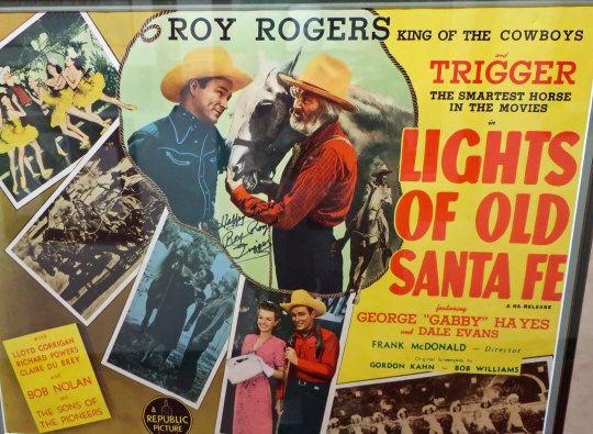
Movies were even more important in establishing the Alabama Hills as a popular filming location for Westerns. Of the over 400 made in the area, the vast majority involved cowboys— and cowgirls— and horses. (I was amused that the horses often got top billing right under the star. Trigger, for example, was listed above and in bigger letters than Roy Roger’s wife Dale on the movie posters at the Lone Pine Film Museum.)
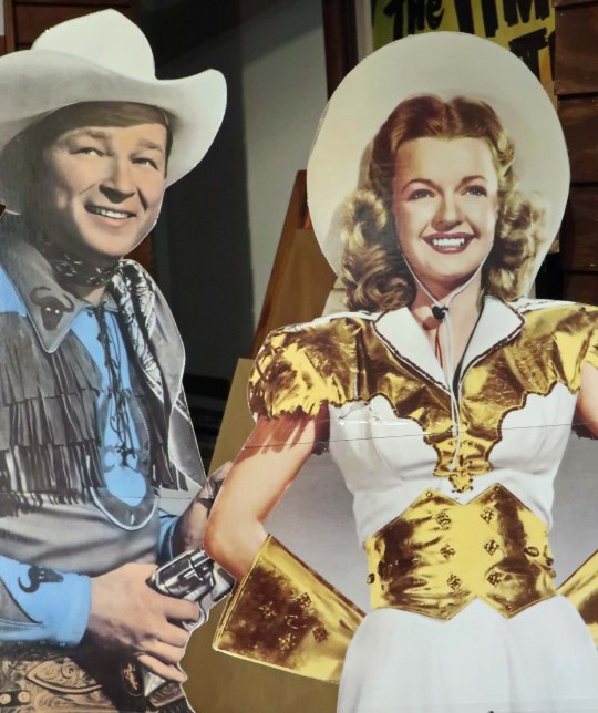
Note where Trigger is in relation to Dale Evans and Gabby Hayes in this movie poster. He’s “the smartest horse in the movies,” the poster declares. It seems he proved it by signing the poster. Must have held the pen in hid mouth. This cut out at museum may suggest why Dale was able to smile while Trigger was stealing the show. It appears that Roy is holding a gun on her!
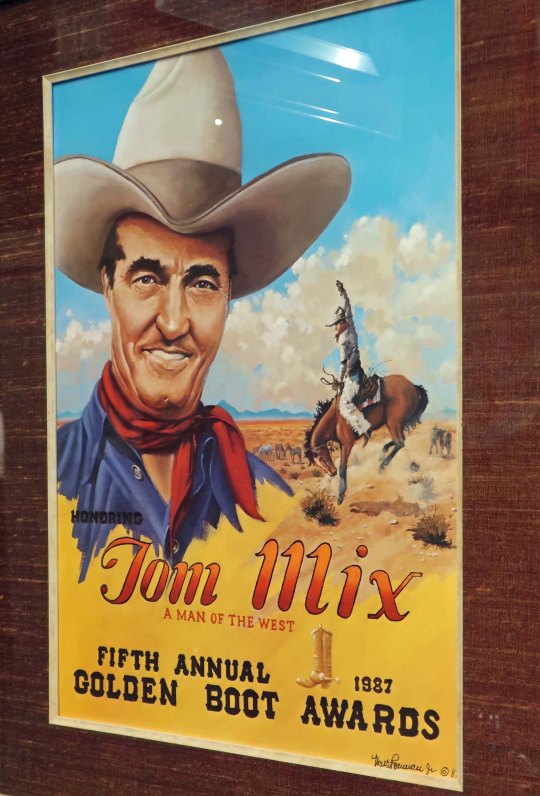
We have to travel back in time to the silent movie era and 1920 for the first Alabama Hills movie, Fatty Arbuckle starring in The Round Up. Will Rogers, the renown humorist, also made a 1920 movie that took advantage of the area, Cupid the Cowpuncher. Tom Mix, the best known of the early movie cowboys, arrived on the scene a couple of years later. Mix was a true cowboy who rode in rodeos as well as starred in movies. He was still making movies in the Alabama Hills when the ‘talkies’ took over from the silent era.
“Nobody loves a fat man” this poster about “Round Up” starring Fatty Arbuckle declares. I suspect that quote wouldn’t make it by the censors today. And, as it turns out, lots of people loved Fatty.Here’s a poster from “Cupid Ties the Knot” starring Will Rogers. Note the gun toting Cupid in the background using a lasso instead of arrows.Tom Mix was recognized for his extensive role in the development of movie Westerns with the Golden Boot award. The bucking bronco in the background reflects his rodeo connection.
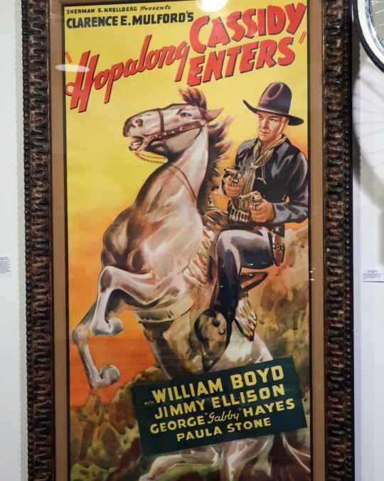
The cowboys just kept riding into the area during the 30s: William Boyd as Hopalong Cassidy, Roy Rogers, Gene Autry, Tex Ritter, Cesar Romero as the Cisco Kid, and John Wayne, to name a few. Boyd would make some 30 movies in the area. Roy Rogers, Gene Autry, and Tex Ritter were singing cowboys, ready to burst out in song at the least excuse. Their guitars were right up there with their horses in importance. The ‘Duke’ spent the 30s as a B level actor producing B level movies. Six of them had scenes filmed in the Alabama Hills. His big breakout movie, the one that would move him up to an A-level actor performing in A-level movies was Stage Coach, directed by John Ford and costarring Claire Trevor. Wayne played the Ringo Kid. Another world-famous actor who had his breakout movie in the Alabama Hills was Humphrey Bogart in the1940 movie High Sierra. The car used in the chase scene from Lone Pine up through the Alabama Hills to Whitney Portal can be found at the museum, along with a cutout of Bogart. Visitors are invited to take their photo with ‘Bogie’ and tweet about it.
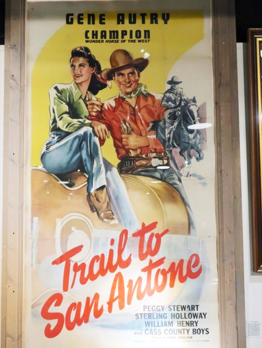
Good guy Hopalong Cassidy also rode a white horse but he wore a black hat.Tex was one of the singing cowboys of the Old West. Here he sits on his horse, White Flash with his guitar in hand.Gene Autry featured his horse Champion like Roy Rodgers featured Trigger. The Cass Country Boys was a country-western band that backed up Gene in some of his songs, including “I’m back in the saddle again.”Champion jumped over a Buick in “Trail to San Antone.” Peggy Stewart was supposedly in the back seat. I think she ducked. I would have. The actual Buick is on display at the museum.A cut out of Humphrey Bogart standing in front of the Plymouth Coupe he drove from Lone Pine to the Whitney Portal in his breakout movie, “High Sierra.”
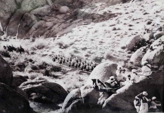
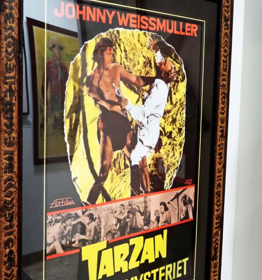
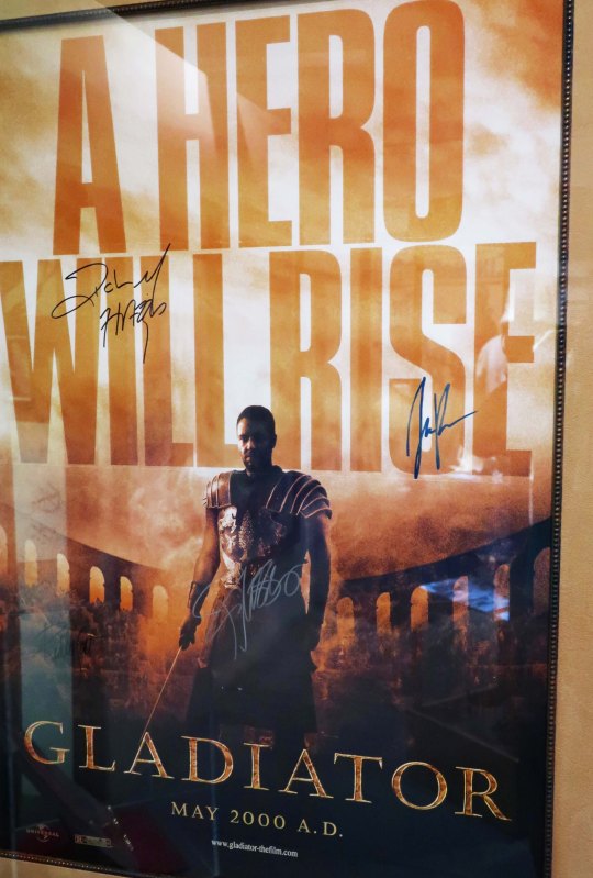
Not surprisingly, as the fame of the Alabama Hills spread in Hollywood, other film genres began to consider producing movies there. The movie Gunga Din, based on the poem by Rudyard Kipling, is a prime example. Why go to India when a day’s drive would get you to the Alabama Hills? Utilizing over 600 extras, the movie starred Cary Grant, Victor McLaglen, Douglas Fairbanks Jr., Joan Fontaine and Sam Jaffe. It was a blockbuster of 1939, second only to Gone with the Wind in box office revenue. Similar in nature, The Charge of the Light Brigade starring Errol Flynn and Olivia De Havilland was another. As was Cecil B. DeMille’s Samson and Davila starring Hedy Lamarr, Victor Mature and Angela Lansbury. Lamarr, known for her sultry look, was also brilliant and helped invent Wi-Fi during World War II. (The Navy suggested she would serve the war effort better as a pin-up but quietly made use of her work.) As for Lansbury, I keep getting this image of her as a singing tea kettle in Beauty and the Beast. Or here’s a fun one in 1943, Johnny Weissmuller in Tarzan’s Desert Mystery. Guess they had to get the ape man out of the jungle. Jumping forward to 2000, we have Russel Crowe in The Gladiator.
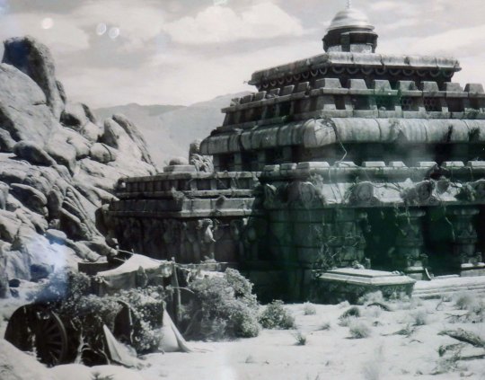
Movie poster from Gunga Din.The British Empire’s troops are about to be ambushed by the Thuggees in “Gunga Din.” Thuggees were a cult of assassins that strangled people and existed in India from the 13th to the 19th Century.This elaborate Thuggee Temple was built in the Alabama Hills for “Gunga Din.”“Charge of the Light Brigade” movie poster.“Samson and Dalila” Movie poster.Another noted muscle man, Tarzan, ventured into the Alabama Hills for this desert adventure. I did wonder how the vine on the left made it into the desert. Once a swinger, always a swinger I guess.Movie poster for “Gladiator.”
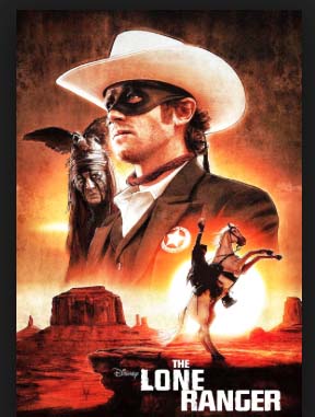
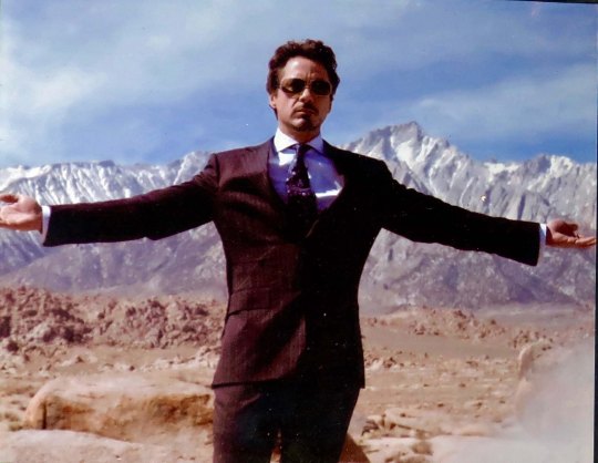
While the use of the Alabama Hills for movies dropped in popularity in the 60s, it continued to be used for the occasional Western. James Coburn in Water Hole #3 in 1967, Clint Eastwood in Joe Kid in 1972, and John Wayne along with Katherine Hepburn in Rooster Cogburn in 1975 are three examples. More recently, Django Unchained directed by Quentin Tarantino in 2012 and The Lone Ranger starring Johnny Depp as Tonto in 2013 used the Alabama Hills in their movies. The other-worldly look of the area also caught the eye of the Sci-Fi/fantasy crowd. It was a natural for an episode of The Twilight Zone. Robert Downey Jr., aka Tony Stark in Iron Man also made an appearance in the Alabama Hills and scenes from Star Trek Generations and Star Trek the Final Generation were filmed there. And finally, the movie, Tremors, was filmed totally on location.
Quentin Tarantino donated the dentist’s wagon that was used in Django to the Lone Pine Museum of Film History.The Lone Ranger looked like the Lone Ranger and Silver looked like Silver. But Tonto had a whole new look. Who would expect less from Johnny Depp?Robert Downey Jr., aka Tony Stark in “Iron Man” enjoys a photo op in the Alabama Hills with Mt. Whitney looming behind.Star Trek also found the other-worldly nature of the Alabama Hills appropriate for outer space and boldly went there.I’ll end my photos from the Lone Pine Museum of Film History with this prop from the movie “Tremors.” I think it looks appropriately alien, or is that nightmarish?
While this post has gone on long enough and you surely get the point of how important the Alabama Hills were to Hollywood, I just can’t help but mention a few more stars associated with movies that used scenes from the area: Gary Cooper, Kirk Douglas, Tim Holt, David Niven, Spencer Tracy, Maureen O’Hara, Tyrone Power, James Stewart, Randolph Scott, Alan Ladd, Jamie Fox, Demi Moore, Nicholas Cage, Jack Lemon, Gregory Peck, Burt Lancaster, Audie Murphy, Brad Pitt, Robert Taylor, Jack Palance, Rita Hayworth, Vincent Price, Mel Gibson, Elizabeth Montgomery, Robert Mitchum, Steve McQueen, Henry Fonda, John Travolta, Mary Pickford, Richard Burton, Cuba Gooding, Bing Crosby, Alec Baldwin, Minnie Driver, Susan Hayward, Kevin Bacon, Rex Allen and Glen Ford. There are some I didn’t recognize but who made a ton of movies in the Alabama Hills in the 20s and 30s including Jack Hoxie, Ken Maynard, Hoot Gibson, Buck Jones and Tom Tyler. There was also Rin Tin Tin, Ranger the Dog, and Johnathan Livingston Seagull! Enough you say? Google “List of movies made in the Alabama Hills” if you want to learn more. Finished. (Grin)
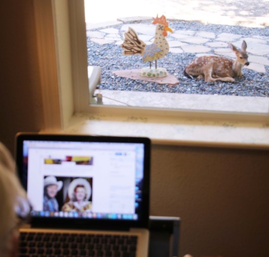
Two more photos. Roy Rogers and Dale Evans had stiff competition in this post. I was working on their photo caption when this fellow popped up in the window in front of me and then laid down a few feet away. I had Peggy come in to take a photo over my shoulder of the latter.
NEXT POST: I’ll travel 10 miles up Highway 395 from Lone Pine and visit the World War II American-Japanese internment camp.
The Alabama Hills as seen from Lone Pine with Lone Pine Peak looming above.
I’m back! While the three months of hanging out at our home and taking care of my brother may not seem like long, it felt like an eternity. I have one more post to write on the experience but it is going to have to wait. It’s play time. While Peggy decided that she needed a kid/grandkid fix and headed east, I decided I needed a road trip. I loaded up Quivera the Van and took off down Highway 395 along the east side of the Sierra Nevada Mountain Range, one of America’s most scenic and interesting drives.
My journey started in Reno visiting the National Automobile Museum. Even if you don’t care a rat’s behind about old cars, I can pretty much guarantee Bill Harrah’s collection will awe you. (Rat’s behind? I’ve been reading Mark Twain’s “Roughing It” and have been inspired by his colorful choice of words.) From there, I headed south, enjoying the sheer grandeur of the mountains with side trips to Virginia City where Samuel Clemens assumed the name Mark Twain, the ghost town of Bodie, Mono Lake with its strange, other worldly tuff towers, a mountain of obsidian, the World War II Japanese internment camp of Manzanar, and finally the Alabama Hills next to Lone Pine and Mt. Whitney.
I stayed in summer-touristy but interesting towns, visited local museums, learned about water wars, and ate some great food. I’ll take you inside the ‘world famous’ Schat’s Bakery in Bishop where simply stepping through the door guarantees that you gain five pounds, and we will stop at the Copper Top, a hole in the wall front yard family bar-b-que in Big Pine that was named America’s best restaurant in 2014 by Yelp. Yep, its ribs and tri-tip are to die for. When the restaurant is closed, you can get the tri-tip from a vending machine.
Originally, my goal was to head farther south to where Highway 395 intersects I-15 and ends. The road had originally gone all of the way to Mexico but had been done in by bulldozers and Southern California freeways. You can still follow the highway to Canada through remote country where there are fewer people and bulldozers. My primary objective had been to visit the Roy Rogers-Dale Evans museum in Victorville near the highway’s terminus. It wasn’t that I was so interested in Roy and Dale, I wanted to see Roy’s horse, Trigger. The singing cowboy had him stuffed. Visiting the horse had been on my agenda for a long, long time. Boy, was I out of date. Googling Trigger, I discovered that the museum had closed in 2003 and the horse had been moved to Branson, Missouri. (I’ve been to Branson; there are lots of strange things there.) Trigger never achieved the stardom in Missouri that he had out West, however. It could be that most of his fans from the 40s and 50s have ridden off into the sunset.Maybe ifDale had stuffed Roy…
Along the way, I was going to make a side trip to the Maturango Museum in Ridgecrest with its focus on the petroglyphs of the Coso Range. That trip ended up on shaky ground, however. The 6.4 and 7.1 earthquakes near the town at the beginning of the month persuaded me that the museum could wait. I just read that there have been thousands of aftershocks since.That’s a whole lot of shaking going on.
Today I will restart my blog— get back in the saddle, so to speak— with a drive through the Alabama Hills, which I think you will find unique and beautiful. I did. Having the Sierra Nevada and Inyo Mountains as backdrops doesn’t hurt. The set locators, directors, actors, script writers and film crews of the over 400 Hollywood movies made in the area starting in the 1920s obviously found the hills attractive. But I will get into the details of the movies in my next post when I will take you into the Lone Pine Film History Museum where Hopalong Cassidy and the Lone Ranger rub elbows with the likes of John Wayne, Errol Flynn, Spencer Tracy, Ann Francis and Spock, not to mention Trigger, Silver, Rin Tin Tin and Buttermilk. Buttermilk!? Hmmm. Okay, you trivia fans, who was Buttermilk?
I first thought that the Alabama Hills had been named by some homesick prospector from the East. That happened a lot in the 1850s, 60s and 70s. Heck, the lonely miners were even known to name mountain lakes after their favorite prostitutes. What I learned, however, was that Southern sympathizers named the hills after the CSS Alabama, a Confederate War ship that had caused the Union considerable strife by taking some 66 merchant ships valued at over six million dollars during its brief two-year career. Its success was finally ended when the Union sloop of war, the Kearsarge, caught up with the ship at Cherbourg, France and sank her. Other prospectors in the Lone Pine area who were sympathetic with the North, named their mine the Kearsarge. The name lives on in the Kearsarge Pass along the John Muir Trail.
A painting of the CSS Alabama.
My nephew Jay and I on Kearsarge Pass. Even at 16, he was towering over me. You may recall that Jay, now in his 30s, backpacked a hundred miles with me last year when I was hiking down the PCT.
But enough on background. Let’s rock!
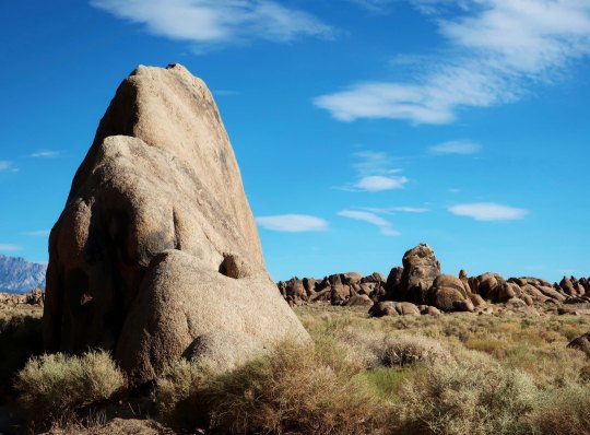
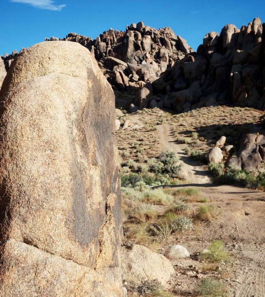
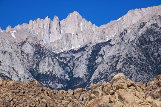
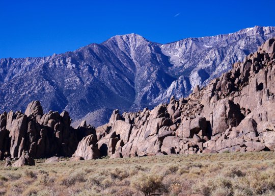
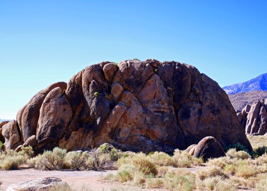
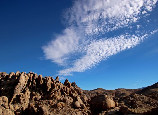
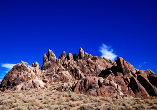
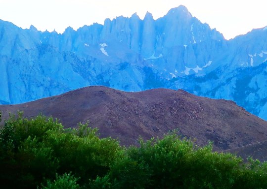
Large, colorful rocks with a dramatic backdrop provided by mountains are what make the Alabama Hills special.Another favorite of mine.Quite the jumble here. Can you spot the crow resting on the far right rock?I captured a fun shot of it taking off. I had our Canon EOS Rebel along this time as well as my Canon Power Shot. I was able to take decent telephotos!Can’t you just see a stagecoach going full speed along this road chased by a group of desperadoes? And then racing across this valley. Or maybe it was the Lone Ranger with his faithful companion Tonto chasing the band of desperadoes. Hi-yo Silver! Get-em-up Scout!This sign is located at the beginning of Movie Flats.The surrounding mountains add drama to the Alabama Hills. These are the Inyo Mountains to the east.The Sierras are to the west. This photo features Mt. Whitney, the highest peak in the contiguous United State. The dark trees in the foreground are Whitney Portal, the starting point for climbing the mountain from the east. I’ve always started from the west side of the mountain. The trail to the top runs along the ridge line. There is one place only a few feet across with a thousand foot drop on each side. Some fun on a windy day! A different perspective on the Sierras.And another on the Inyo Mountains.Getting back to individual rocks, this one was impressive.So I rendered it in black and white, just like you would see in the dozens of cowboy movies dating all the way back to the silent film era.Here are a few more interesting rocks.The white containers protect plants.I conclude as I started, with a photo of the Alabama Hills from Lone Pine. This time I took the photo in the evening and had Mt. Whitney as a backdrop.
NEXT POST: A visit to the Lone Pine Film History Museum.
My brother, Marshall, wandered happily for 17 years, free camping and spending most of his time sitting outside and enjoying nature. He loved our property for its woods and wildlife. This was one of his favorite locations. His chair is now vacant.
I was with Marsh when he died on June 2, gently holding his shoulder. His hospice nurse, C, was holding his hand and quietly taking him through a beautiful meditation. She included the deer herd that had come down off the hill and stood around the RV. Coincidence? Probably. We normally have three or four that live on our property. But this time there were nine or ten. The extras had shown up when Marsh had come in from wintering in Arizona. Last summer he house-sat for us while Peggy and I were backpacking on the PCT. He was very generous with apples, a fact the local deer had shared with their country cousins.
When I went out to tell Peggy that Marsh had passed, the deer herd had disappeared. Only Floppy, named for her ears, was still there. She was Marsh’s favorite and had always been able to talk him out of an apple. She waited until the hearse arrived and took Marsh’s body away. She watched as it drove up the hill and then walked over and sniffed his chair. A final farewell, perhaps. She then hurried off to our canyon where she had hidden her fawn. I had hoped she would bring the baby by while Marsh was still alive, but a cougar hunting in our area made her more wary than usual. Our next-door neighbor had called three weeks earlier to tell us that the cougar was sleeping in her yard. We were all more cautious.
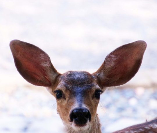
Floppy, hanging out near Marshall’s chair.A couple of weeks after Marsh died, Floppy brought her fawn down for a visit.Marsh would have loved this little fellow with its curiosity about everything and its tendency to cavort.
I found Peggy busy watering the honeysuckle Marsh had urged that we plant in our yard. It was her way of honoring him. He and I had grown up in Diamond Springs, California in the 40s and 50s with a large trellis of it outside our bedroom window. It was packed with flowers in the spring. At night when we went to bed, its delightful fragrance would come drifting in our open windows. Peggy had planted ours in April and it was in full bloom in May. Each time my brother walked by it, even when he could barely walk, he would stop and admire it, a fitting, living memorial.
The honeysuckle provides a backdrop for our two ceramic Steller jays, which was appropriate because Marsh was aways amused by the antics and personality of the jays that live around our house.One challenge that the jays faced and overcame was how to get birdseed out of a feeder that was made for smaller birds. By perching on the pole and reaching out as far as their neck could stretch, the birds could just reach the feed.
Utilizing Oregon’s Death with Dignity law, Marsh had chosen the time and place of his death. When he had called in March, he had told me that his tongue and throat cancer were back. He had fought a valiant battle in Florida five years earlier. It had allowed him to continue doing what he loved to do— wander. He had spent two more years migrating between North Carolina and Florida as he had for 13 years and then moved West to travel between Oregon and Arizona. At 78, he had decided to let the disease run its course. There would be no ambulances, no emergency rooms, no ICU’s, and no tubes keeping him alive into insensibility. He requested that I be empowered to make decisions through an advanced care directive and a dual power of attorney to make sure his wishes were followed if he were incapacitated. I drafted a will for him based on his desires and we signed him up for hospice care. It was his intention to die in our back yard.
Marshall’s preference was to simply go to sleep and not wake up, peaceably drifting off to nothingness or wherever else death might take him. While neither of us is religious, we both believe the universe is a wondrous place, full of the unknown. He had gone through the process of signing up for Oregon’s Death with Dignity as an option. It was a detailed process. Two physicians had to agree that Marshall had less than six months to live and that he was mentally capable of making the decision to end his life. He had to state his desires both orally and in writing some 15 days apart. And, in the end, he had to be able to sit up and drink the medication on his own without help. Two End of Life volunteers, Tall M and Short M, had met with us to discuss what the procedure would entail if he chose to use it. Everyone, including doctors, end of life volunteers and hospice workers had emphasized that he could change his mind at any time, right up until he drank the medication. It was his decision— and only his decision to make.
As the weeks passed, Marshall failed rapidly. His tongue and throat cancer made it difficult to eat, drink and talk. Eating or drinking anything caused him to cough. Never big, his weight had dropped from 120 to 85 pounds from February until June. His skin draped over his bones. During his last week, his food had consisted of two 8-ounce bottles of Ensure. Earlier, he had desperately wanted to eat something else. He tried scrambled eggs and could only eat a couple of bites. “But those bites tasted so good!” he had exclaimed. I made him a fruit smoothie as recommended by his hospice team that he drank with delight. I cooked him one of his favorite veggies, acorn squash, to the consistency of baby food and he ate a whole bowl. But those were exceptions, and he didn’t want more.
When it became obvious that he had only a week or two left and he would be confined to bed, he decided to it was time to end his life. Being fiercely independent, he couldn’t imagine lying in bed while someone attended to his every need. He set Monday, June 3, four days away. Marsh decided to spend Thursday outside enjoying nature, which is what he had been happily doing for 17 years, except when driven in by the weather to his tent, van or RV. He had me cut up a bowl of apples for his deer visitors and insisted that I cover the apples with water so they would be fresh. Peggy and I sat with him. That evening, I joined him in the RV to keep him company. He asked for help walking to his bed and collapsed in my arms. I had to carry him. I worried that he had waited too long, that he would end up helpless, unable to meet the requirements of Death with Dignity.
His hospice nurse came in on Friday morning. I am convinced that these women and men who devote their lives to helping people ease their way out of life are as close to angels as we come on this earth. I say this not only for the expertise, peace and comfort they brought to Marshall, but for the knowledge and comfort they brought to Peggy and me. The End of Life volunteers that functioned as a support team under Oregon’s Death with Dignity law were equally caring and supportive. C talked to Marsh about his rapidly ebbing life. And Marsh, out of caution, moved his date from Monday to Sunday morning at 10:30. He also sat up and drank an Ensure in under ten minutes to prove that he could swallow the medication in the time required. Time is important because the medication contains a potent medicine that puts you to sleep in a few minutes. You need to drink all of the medicine before then.
While Marsh was meeting with C, I drove into Medford and picked up his medicine. Only two pharmacies in Medford carry it. Again, there are stringent safety rules. I produced both my driver’s license and my dual power of attorney. The doctor’s prescription had the wrong date for Marshall’s birth. Fortunately, the POA showed the correct date. I waited while the mistake was cleared up with the doctor. The whole experience felt strange and almost surreal. I was collecting the medicine that would lead to my brother’s death.
On Saturday Morning, I joined Marsh in his RV at 9:00. As I walked in he gave me a big smile and a thumbs-up. He had managed to get dressed, was sitting at his breakfast table, had drunk another Ensure, and had written up a to-do list for me. Among other things, he wanted to make sure that his beer found a good home. He’d bought a couple of cases of Miller Ice at Walmart to see him through his last weeks and then couldn’t drink it. (I gave it to Ed, my barber. Ed greets Pacific Crest Trail hikers as they cross the Oregon border into California with food and drink. Having hiked over 700 miles of the trail myself last summer, I knew how much the beer would be appreciated.)
I sat with Marsh all day while we listened to music from his 40s, 50s and 60s collection, sad songs and love songs from an almost forgotten era. He could barely talk. We communicated when necessary by writing notes. Mainly we sat in quiet, supportive silence as the music took us back in time to when we were young. He checked his watch often as the seconds, minutes and hours wound down.
I was out early on Sunday morning. I knew Marsh would want to be up and I needed some time on my own to prepare for the day. At eight I went out with a cut up apple and left it where I keep a deer block to supplement the does’ diets when they are nursing. I thought of the apple as an offering. Decades earlier, when I had been a Peace Corps Volunteer in West Africa, I often found food left at the base of towering cottonwoods as I hiked down jungle trails. It had been left for the spirits that resided in the trees. I’d been fascinated by the ritual. As I placed the apple on the deer block, I asked the forest spirits, or whatever gods that were listening— if any— to make Marshall’s passing easy and give him peace.
Marsh was in his bedroom. “I am so glad you came early,” he whispered. “I tried to call you on the walkie-talkie but couldn’t make it work.” Technology wasn’t his thing, to put it mildly. He was still in bed, unable to dress. I helped him pull on his pants and socks. He had me pick out a handsome, long-sleeved pullover. He wanted to look good. Marsh asked for my hand in standing up but insisted on walking out to his couch, carefully holding onto things as he went. It was to be his last walk; he wanted to do it on his own. He sat up straight, fighting sleep. Peggy came in, sat down beside him, and held his hand. She and I shared stories and even laughter, helping Marshall pass the time and letting what we feel for each other include him. He started coughing so I offered to place some liquid morphine under his tongue. C had told us it would relax him and help reduce the coughing. Marshall agreed since coughing might interfere with taking the medicine. Although the hospice team had brought the morphine on its first visit, he had refused to use it. He was proud of the fact that he had reached 78 without prescribed medications and had been feeling only minimal pain.
C drove down our road at 9:30 and joined us. While hospice nurses are not allowed to mix or provide direct help in consuming the medicine, they are allowed to give comfort. Their presence is totally volunteer. Marsh had wanted C to be there and she had readily said yes. I brought out the anti-nausea medicine he was supposed to take. Throwing up was not an option. I told Carrie some of my favorite Marshall stories while we waited for the End of Life volunteers, again helping him pass the time. He grinned when I told his favorite tales.
Tall M and Short M arrived at 10:00. Peggy and I went into our house to give the three time to meet with Marsh. Their job was to assure that he still wanted to take the medication and to determine whether he would be able to sit up and drink it. Short M told us later that he had dozed off while talking with them. He had awakened with a start. “Am I dead?” he had asked. All four, including Marsh, had shared a laugh. After a very long 15 minutes, the EOL volunteers came in and told us that he still wanted to take the medication and that they felt he could manage it.
While Peggy stayed with the volunteers to assure they had what the needed to prepare the medicine, I went out to share my last minutes with my brother.
Tall M came in with the medicine in a glass and handed it to Marshall. She also brought apple juice. The medicine is said to be extremely bitter. The apple juice would help counter the taste. There was absolute silence as Marsh took his first sip: silence out of concern and out of respect. The concern was real, intense. Could Marsh finish the drink before he fell asleep? Would drinking the medicine cause a coughing fit? Would his passage be easy? While people drinking the medicine go to sleep immediately, it normally takes 30 minutes or so to die. It can take up to 20 hours.
The seconds passed, becoming minutes. Marsh moved slowly. Stopping to look at the glass or to sip apple juice. I quietly spoke encouraging words to him. We all did. Then he was finished. He motioned for the apple juice, raising it toward his lips as C began her quiet meditation. It never made it. A tear formed in the corner of his eye. I gave his shoulder a squeeze and whispered “We love you.” And he died. A quiet, dignified death.
Peggy went out later to tell him goodbye. The EOL volunteers had laid him out. “He looked so peaceful,” Peggy told me. “His eyes were closed and his lips were parted like he was sleeping.” Or maybe he was smiling.
Marshall, who described himself as ‘An Itinerant Idler,’ happily spent 15 years migrating between the mountains of North Carolina and the swamps of Southern Florida. Rest in peace, Brother. May you continue to wander.
I got the call from my brother Marshall in mid-March. He had house-sat for us while Peggy and I were off backpacking last summer. Then, as he has been doing for 17-years, he hit the road, heading for Arizona where he would winter. He’d come West the year before, ending his 15-years of migrating back and forth between North Carolina and Florida, as regularly as the birds. Oregon would be his new residence. Four years ago, he had fought tongue cancer in Florida, free-camping while he had extensive treatments. It was his way. I had flown in to spend some time with him. He had won that battle, a temporary reprieve that allowed him to continue to wander, which is what he loves to do.
The phone call was serious. His cancer was back. He wasn’t going to fight it. At 78, he was coming home to die. His wandering days were over. A couple of days ago I found him talking to his RV. “I know, big fellow, you want to be on the road as much as I do, but we can’t.”
For the past two months, Peggy and I have been caring for Marshall. He is living in our back yard in his RV. It’s where he wants to die. Marshall has hospice care now and the team is excellent, providing support for us as well as him. They are warm, caring people. None of this easy. It’s incredibly tough watching someone you care for waste away and die. It may be days, or weeks, but probably not months. Each morning when I go out to visit, I wonder.
I’ve decided to check out of my blog for now, for at least a couple of months. I need the time for Marsh, and Peggy, and me. I’ll be back. My blog and my blogging friends are part of my family. Until next time, take care my friends.
Since my blog features travel, outdoor adventures and Burning Man, I usually don’t discuss politics here, other than an occasional comment. This doesn’t mean that I’m not concerned about what is happening in the nation and world. In fact, I am deeply concerned. And occasionally this concern slips over into my blog. Today is one of those occasions. I have been reading the Mueller Report.
I highly recommend that people who are interested in the future of America (and other democracies throughout the world) do likewise. Going to the source provides a different perspective that is well worth the effort. The report is on-line, easy to download, and free (download a copy here). Regardless of how people feel about the relationship between the Presidential campaign and Russia, there is no doubt that the Russians made an all-out effort to impact the American election and sow discord in the nation by utilizing social media in 2016— all the while posing as someone else.
We’ve heard a lot about Russia using Facebook and Twitter, but it also used YouTube, Tumblr, and Instagram. But what about WordPress? That’s where Lucifer and Guccifer come in. Lucifer, as you know, is the devil. You might think of Guccifer as his evil twin brother in disguise. Guccifer 2 was the WordPress site created by the GRU, the main military foreign-intelligence service of the Russian Federation, to release the data that it had stolen/hacked from the Democratic National Committee and the Hillary Clinton campaign.
Here is a section of the Mueller Report that addresses Guccifer 2 found on pages 42-45:
“On June 14, 2016, the DNC and its cyber-response team announced the breach of the DNC network and suspected theft of DNC documents. In the statements, the cyber-response team alleged that Russian state-sponsored actors (which they referred to as “Fancy Bear”) were responsible for the breach. (145) Apparently in response to that announcement, on June 15, 2016, GRU officers using the persona Guccifer 2.0 created a WordPress blog. In the hours leading up to the launch of that WordPress blog, GRU officers logged into a Moscow-based server used and managed by Unit 74455 and searched for a number of specific words and phrases in English, including “some hundred sheets,” “illuminati,” and “worldwide known.” Approximately two hours after the last of those searches, Guccifer 2.0 published its first post, attributing the DNC server hack to a lone Romanian hacker and using several of the unique English words and phrases that the GRU officers had searched for that day. (146)”
(If you want to keep a secret, you shouldn’t leave behind such an obvious trail)
“That same day, June 15, 2016, the GRU also used the Guccifer 2.0 WordPress blog to begin releasing to the public documents stolen from the DNC and DCCC computer networks. The Guccifer 2.0 persona ultimately released thousands of documents stolen from the DNC and DCCC in a series of blog posts between June 15, 2016 and October 18, 2016. (147) Released documents included opposition research performed by the DNC including a memorandum analyzing potential criticisms of candidate Trump, internal policy documents (such as recommendations on how to address politically sensitive issues), analyses of specific congressional races, and fundraising documents. Releases were organized around thematic issues, such as specific states (e.g., Florida and Pennsylvania) that were perceived as competitive in the 2016 U.S. presidential election.”
“Beginning in late June 2016, the GRU also used the Guccifer 2.0 persona to release documents directly to reporters and other interested individuals. Specifically, on June 27, 2016, Guccifer 2.0 sent an email to the news outlet The Smoking Gun offering to provide “exclusive access to some leaked emails linked [to] Hillary Clinton’s staff.” (148) The GRU later sent the reporter a password and link to a locked portion of the dcleaks.com website that contained an archive of emails stolen by Unit 26165 from a Clinton Campaign volunteer in March 2016. (149) That the Guccifer 2.0 persona provided reporters access to a restricted portion of the DC Leaks websites tends to indicate that both personas were operated by the same or a closely-related group of people.”
“The GRU continued its release efforts through Guccifer 2.0 into August 2016. For example, on August 15, 2016, the Guccifer 2.0 persona sent a candidate for the U.S. Congress documents related to the candidate’s opponent. On August 22, 2016, the Guccifer 2.0 persona transferred approximately 2.5 gigabytes of Florida-related data stolen from the DCCC to a U.S.blogger covering Florida politics. On August 22, 2016, the Guccifer 2.0 persona sent a U.S.reporter documents stolen from the DCCC pertaining to the Black Lives Matter movement.”
“Around the same time, WikiLeaks initiated communications with the GRU persona Guccifer 2.0 shortly after it was used to release documents stolen from the DNC. On June 22, 2016, seven days after Guccifer 2.0 ‘s first releases of stolen DNC documents, WikiLeaks used Twitter’s direct message function to contact the Guccifer 2.0 Twitter account and suggest that Guccifer 2.0 ” send any new material stolen from the DNC here for us to review and it will have a much higher impact than what you are doing.” (160)
“On July 6, 2016, WikiLeaks again contacted Guccifer 2.0 through Twitter’s private messaging function, writing, “if you have anything hillary related we want it in the next two days preferable because the DNC is approaching and she will solidify bernie supporters behind her after.” The Guccifer 2.0 persona responded, “ok… i see.” WikiLeaks also explained, “we think trump has only a 25% chance of winning against hillary … so conflict between bernie and hillary is interesting.” (161)
I don’t have a clue if other WordPress sites were created to generate conflict in the US. WordPress has been conspicuously silent on the whole issue.
Now, your feeling might be, “Oh this is just politics as usual.” And if the election turned out the way you wanted, you might even feel that the interference was a good thing. Except it isn’t. Consider this. What if a Russian sub slipped along the Maine Coast and a group of armed soldiers disembarked for some nefarious purpose, say knocking out the power grid for the Northeast. It would be an act of war. And it would be an act of war regardless of whether you were on the right, left, or center of the political spectrum. Millions of Americans have given their lives to protect us against such a scenario. If an American of left, right or center persuasion aided the Russians in their efforts, it would be considered treason. Plain and simple.
Next, think of this. Vladimir Putin and the GRU are not America’s friends. Their total objective is to weaken the United States and other Western Democracies— to replace freely elected governments with something closer to Russia’s government where tyranny, secret police, rigged elections and controlled press dominate. And to create governments willing to look the other way as Russia re-conquers the territory it lost at the end of the Cold War, using whatever force is required.
And finally, this. The nature of warfare has changed. Yes, ships and planes, and bombs, and missiles, and guns and soldiers are still part of it. But cyber warfare has become a major new player. And it is much more insidious. In 2016, the Russians invaded America. Their efforts went far beyond trying to discredit Hillary Clinton and the Democrats. For one, they tried to hack our voting system. Picture going to the polls, voting, and having your vote changed, or lost. To the degree such an effort is successful, it goes to the very heart of our democratic system. It creates distrust in the system. It destroys the system.
Even worse, Russia tried to sow hatred and discord between groups of Americans, between ethnic groups, between religious groups, and between political groups. That such tensions already existed in America is obvious. It is also obvious that the strength of our nation, and all democracies, lies in the ability of various groups to work together for the better of the whole, to take advantage of the strengths the various groups bring to the table, and to compromise when necessary. The future of America (and the world) is based on bringing people together, not tearing them apart.
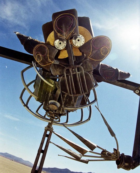
A robot boy and his dog check out the building of Medusa. She will show up in my next post. Beware of her eyes! (Well, maybe my next post— after I report on how the Russians used WordPress as a key tool in their efforts to disrupt the American elections of 2016.)
I often think about how are lives are impacted by robots. Peggy and I even have one of the small vacuum cleaners that runs around and cleans our floors and carpets. We call her, Robota. As I grow older, I look more fondly on the robots of the future. In 10 or 15 years from now when the world decides my driving leaves a bit to be desired, I am hoping there is a self-driving car sitting in my yard or readily available to zip me around to where I want to go. Next stop, Grand Canyon. Then there is the downside. Maybe when robots are given quantum computer brains, they will decide we aren’t necessary. I seriously doubt that they will approve of our ‘pulling their plugs,’ under any circumstances.
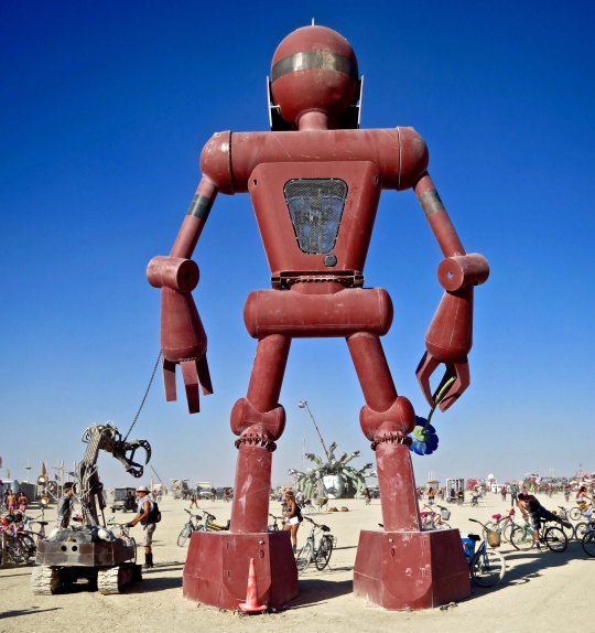
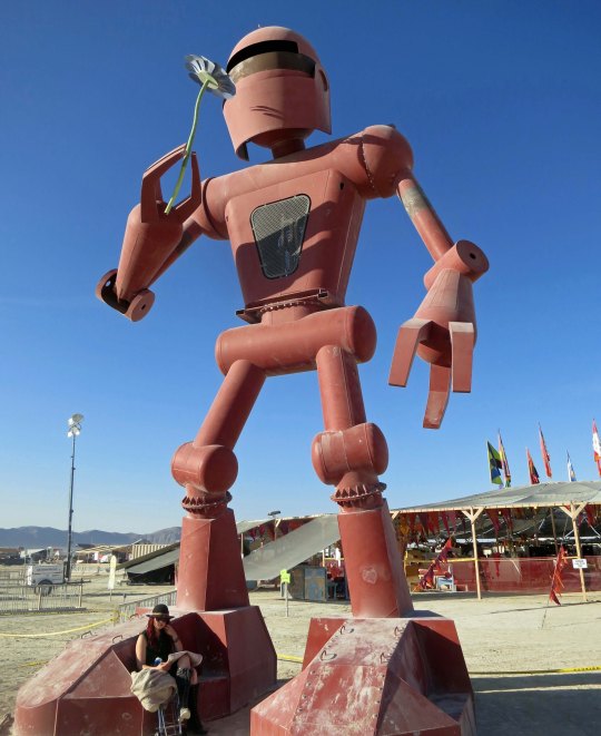
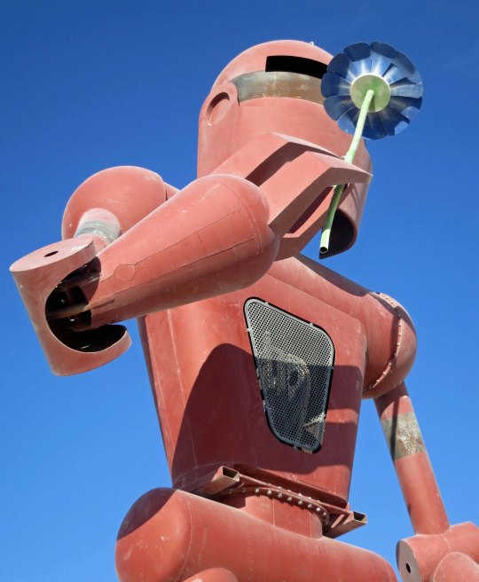
What’s the danger of a flower sniffing robot, however? This fellow was given one of Burning Man’s prime locations, just in front of the Center Camp Cafe bordering on the Playa. The woman provides some perspective on his size.
Fido appears a little questionable. Maybe she is howling at the moon.
It appears our robot is more sinister here. What happened to the rider of the bike he is holding? Is it time to run?
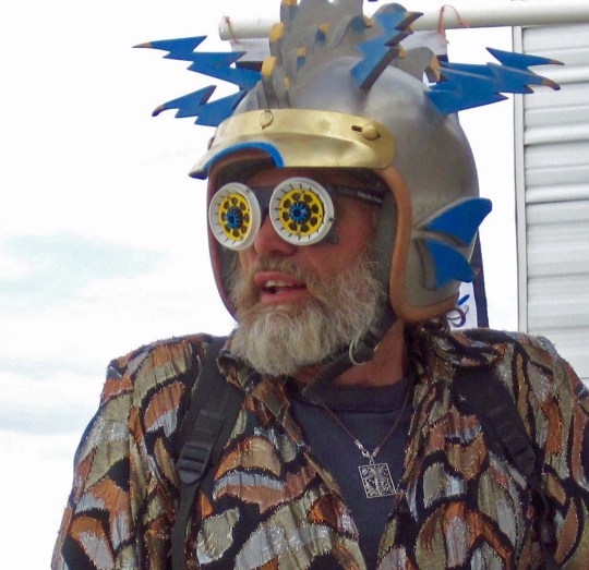
This robot looks like it was an extra in a 1950’s sci-fi movie.
No question here. Run for it!
Spotting this creature, I’d want a bunch of Burners between me and it.
I think the red eye glowed a dangerous red at night.
A bit more personality.
Aliens are another matter. Maybe they are already here. I’ve blogged several times about the UFO I saw over Sacramento circa 1968. If there are aliens, it seems obvious to me that they would show up at Burning Man. Think about it: a remote desert where it is easy to disguise yourself and people don’t care if you are an alien. Each year there are a number of candidates.
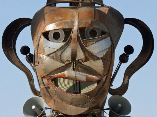
This guy shows up as a master of ceremonies every year at the annual costume contest. What better way to infiltrate Burning Man?
This one showed up in our camp and demanded a beer, an expensive beer. (Photo by Tom Lovering.)
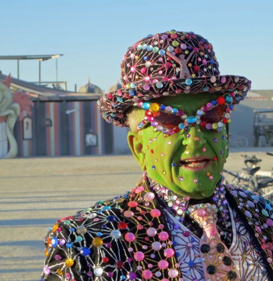
I’ve always been suspicious of purple people. Remember, “He was a one eyed, one horned, flying purple people eater?” Or are you too young?
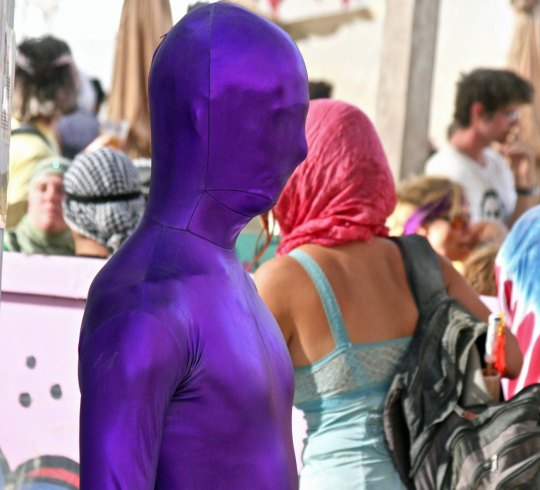
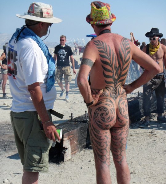
Or maybe their disguises are more subtle. Slap on a few tattoos and you can get into any party at Burning Man.
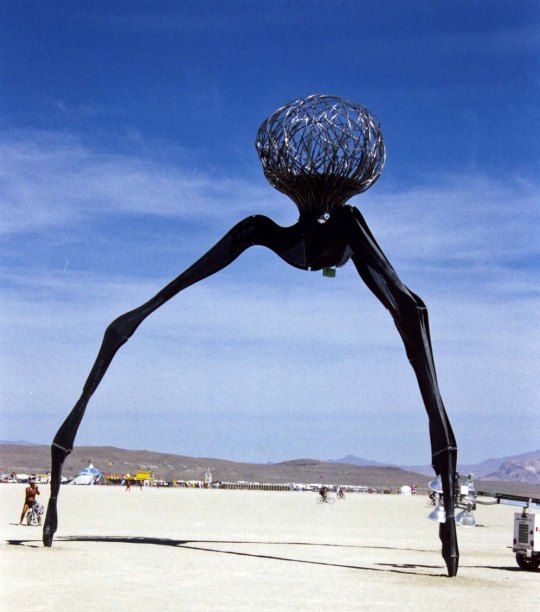
Flying saucers aren’t unheard of in the Black Rock Desert. One year we even had one crash.
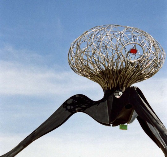
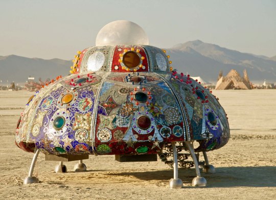
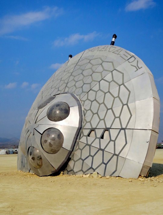
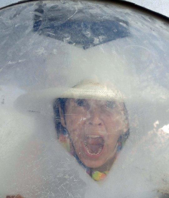
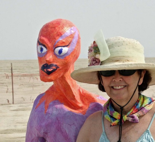
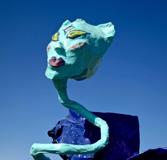
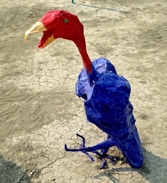
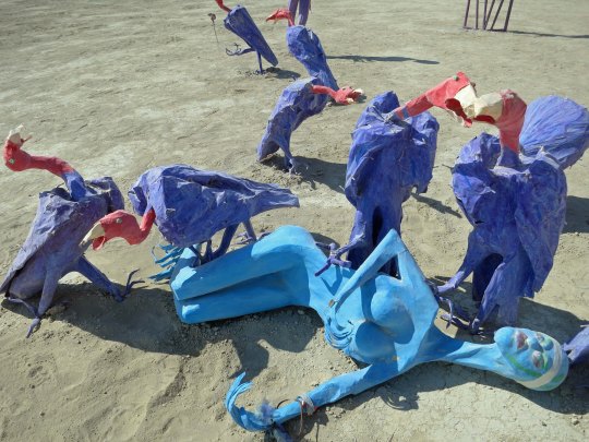
How much more attractive can a flying saucer get? Aliens contracted with a group of kids in the Bay area to create this one.But then there was the crash…Rumors were that a human the aliens had captured was a notorious back-seat driver and had caused them to crash.The way she buddied up to aliens later seemed to confirm this suspicion.Undoubtedly part of the crew.Alien buzzards tend to be a little scary.And they may be the reason that there are so few alien bodies found. They are also known to snack on Big Foot, or is that Big Feet?
Enough on Invaders from Outer Space. My next post will feature invaders from Russia.