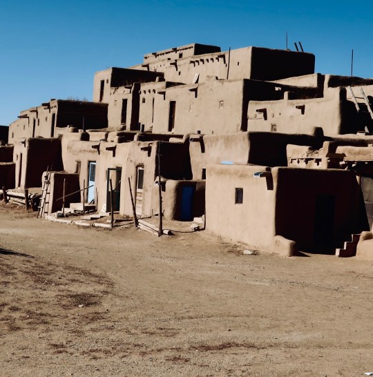
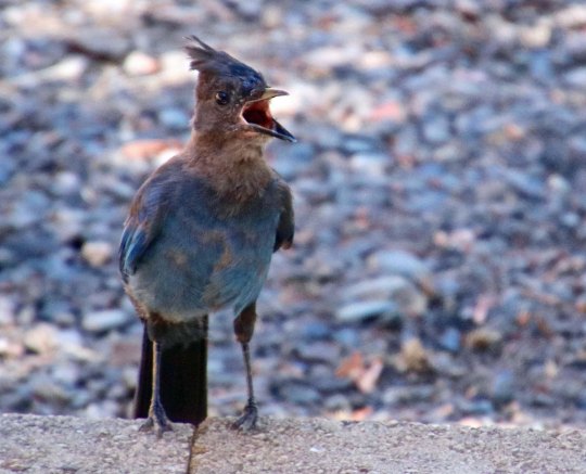
With over 1,000 years behind it, the Taos Pueblo is the oldest continuously inhabited community in America. The Pueblo had already existed for 500 years when Columbus sailed for the New World in 1492. When Spanish explorers arrived in 1540, they thought they had found one of the seven golden cities of Cibola. (Photo by Peggy Mekemson.)
Mable Evans Dodge Sterne Luhan, whose long name represented her husbands, lived a soap opera kind of life. A wealthy socialite born in Buffalo, New York, she devoted her time to supporting art and bringing together the artists and intellectuals of her time: Gertrude Stein, Alice B. Toklas, Andre Gide, Lincoln Steffens, Walter Lippmann, Pablo Picasso, Arthur Rubenstein, D.H. Lawrence, Ansel Adams, Willa Cather, Aldous Huxley, Greta Garbo and Georgia O’Keeffe to name a few.
Her efforts at creating artistic gatherings began in Florence, Italy where she and husband number two, Edwin Dodge, lived in a villa that had been built for the Medici. In 1912 she moved on to New York City and established a salon hosting both artists and leading radicals who espoused causes ranging from free love, to Freud, to anarchism. When she heard about the beauty of New Mexico, she sent husband number three, Maurice Sterne, west in 1917 to explore the possibilities of moving there. He wrote back, “Dearest Girl–Do you want an objective in life? Save the Indians, their art and culture. Reveal it to the world!” That was enough for Mable. She was on her way.
One of the first Indians she met in Taos was Tony Lujan, a member of Taos Pueblo. Tony persuaded Mable to buy several acres of meadow land and then helped her plan and build a four-room adobe house that continued to expand until it reached 21 rooms. The story is told, and it may be apocryphal, that Tony set up a tent in her front yard and drummed away in the night to win her love. Maurice bought a shotgun. Whether it was to eliminate the competition or do away with the infernal nighttime drumming and get a decent night’s sleep, I can only speculate.
Anyway, Mable sent Sterne packing and married Tony, her fourth and final husband. With a large house and a Native American husband, she could now focus on her plan to bring artists, writers and movie stars to promote Taos and help save the Indians and their culture. One of her major successes at recruitment was D.H. Lawrence of Lady Chatterley’s Lover fame. Another was Georgia O’Keeffe.
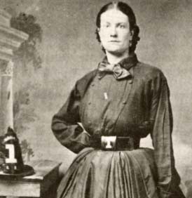
A young Mable Dodge Luhan looking like the weathy socialite she was.The Luhan House/Hotel in Taos as it looks now. Dennis Hopper stayed here when he was filming “Easy Rider” and proceeded to buy it in 1970. For seven years it was more or less a “hippie hangout.” It is now operated by a non-profit as an historic hotel and conference center. Visitors can rent the room that Georgia O’Keeffe stayed in if they wish.A large rooster with his chest puffed out perches on top of the house and serves as a weather vane. Apparently, there was a south wind blowing when we visited.This fellow ruled a lower perch and was one of several brightly colored ceramic roosters that decorate the house.Smaller members of the bird kingdom live here as well. Lots of them. They had all flown south for the winter, however.They likely perch in the magnificent cottonwoods that tower over their homes when they are in town. I can easily imagine O’Keeffe painting the trees.Peggy and I found this interesting stairway at the back of the house…And a sculpture by Ted Egri out front.
Luhan met O’Keeffe in New York City through Georgia’s husband, Alfred Stieglitz, and immediately initiated a campaign to persuade her to visit Taos. Stieglitz, a leading photographer of the time, was instrumental in persuading the art world that photography could be art. Among his projects was photographing Georgia nude and hanging the photos in his famous modern art gallery at 291 5th Avenue. The exhibit was quite controversial. He also hung original art from Matisse, Picasso, Rousseau, Rodin, and Cezanne— introducing Americans to avant-garde European artists. He produced show after show of O’Keeffe’s paintings, adding to her credence as a world-class artist, not to mention selling her paintings for hefty sums.
In the summer of 1929, O’Keeffe finally took Luhan up on her offer and journeyed to New Mexico, partially because Stieglitz was having an affair with the young wife of an heir to the Sears and Roebuck fortune some 40 years his junior. But the bottom line was that O’Keeffe was introduced to Taos and fell in love with New Mexico. She brought her friend Rebecca ‘Beck’ Strand with her. Beck’s husband was Paul Strand another top photographer and, like Georgia, a protégé of Steiglitz. During a visit at Luhan’s in 1930, he met Ansel Adams and persuaded him to pursue a career in photography. Adams had been trained as a concert pianist.
Today, I will focus our remaining photos on the Pueblo, Taos and the surrounding country.
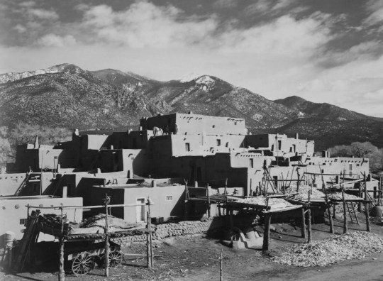
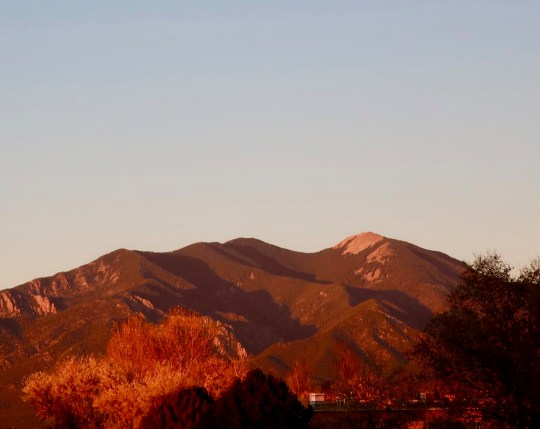
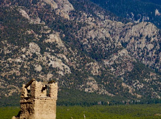
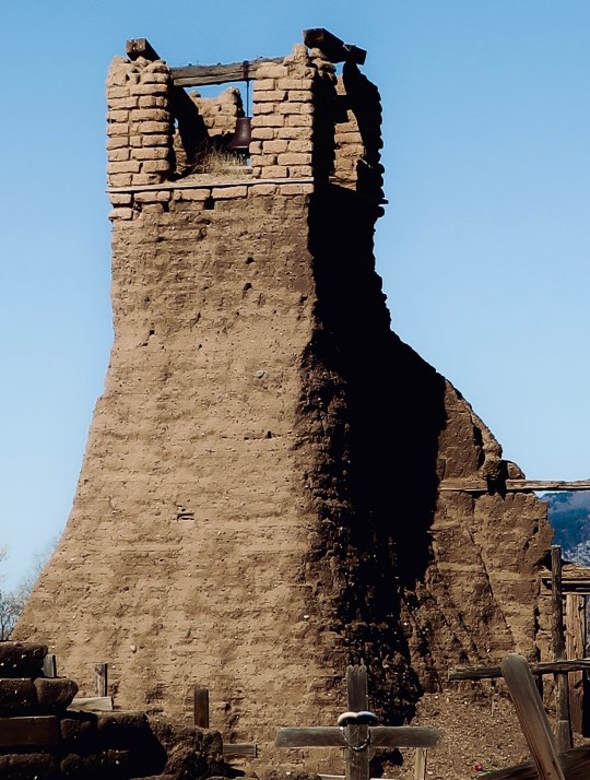
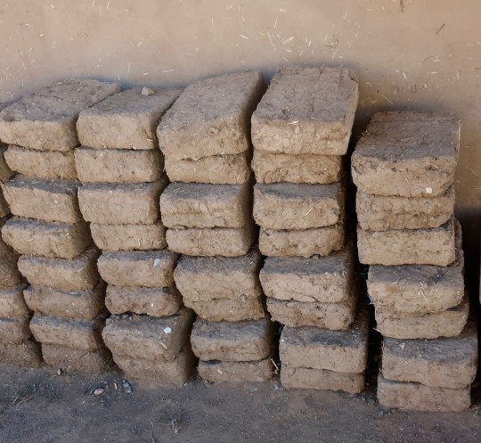
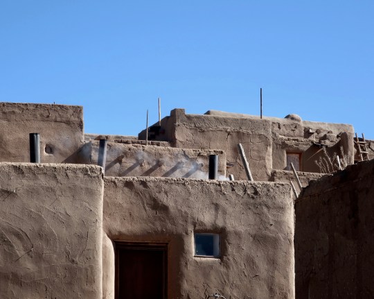
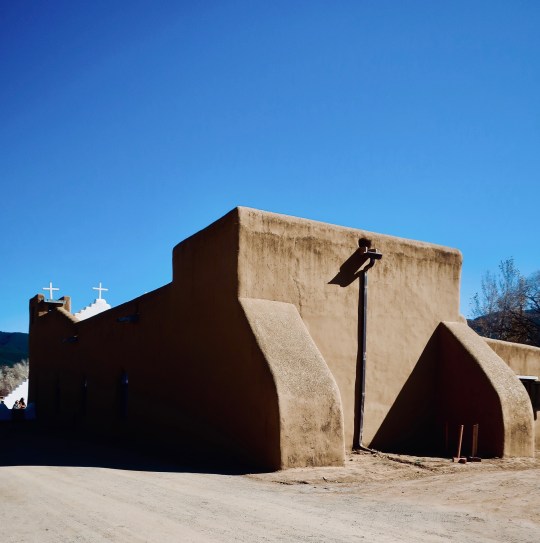
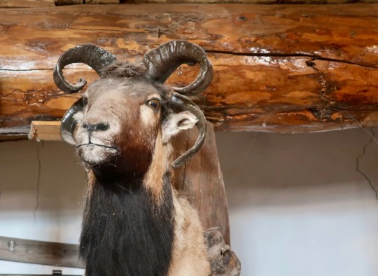
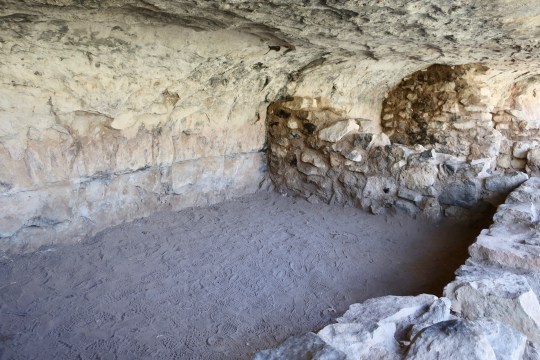
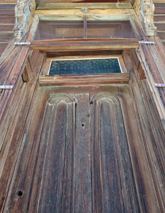
Georgia O’Keeffe’s painting of the Taos PuebloA photo I took of the Pueblo shows how little it has changed in the 90 years since O’Keeffe painted it. The round structures in front are ovens. Peggy and I ate some pie cooked in one. Quite tasty.Here’s a close up of one of the ovens. (Photo by Peggy Mekemson.)A photo by Ansel Adams of the Pueblo. Note the Taos Mountains towering in the background. They are part of the Sangro de Christo Range, or as translated, the Blood of Christ Range. It seems like a strange name for mountains.Possibly the early Spaniards noticed the mountains in a fall sunset like I did from our campsite.Georgia O’Keeffe’s painting of Taos Mountain. Our guide told us that the early Indians would post a lookout on the granite outcrop to the right overlooking the Pueblo and could see enemies approaching from miles away. The ruins of the San Geronimo Church, destroyed in 1846 by American forces can be seen on the left. (Photo by Peggy Mekemson.)The ruins of the church overlook the Pueblo’s graveyard. (Photo by Peggy Mekemson.)A close up of the ruins.The Rio de Taos Pueblo flows through the center of the Pueblo, separating the North House we have been looking at from the South House. The creek was looking a bit cold when I photographed it. Our guide told us we were not to swim in it. No problem.Peggy took this photo of the South House with its colorful doors and still melting snow.I don’t know if the inhabitants regard the numerous ladders used to negotiate between floors as photo-worthy, but we did. (Photo by Peggy Mekemson.)Peggy and I learned about adobe maintenance and repair when we visited the Pueblo. The adobe structures need to be recoated annually with a mud and straw mixture. More serious repair work requires these mud and straw bricks. I lifted one. It must have weighed close to 50 pounds.As I thought of all the work involved in maintaining these structures, I came to appreciate that we only have to paint our house every ten years or so and replace the roof once every 20 years. (Not that I ever lived anywhere long enough to replace a roof.)The Catholic Church at the Pueblo reminded me of the San Francisco de Assi Church.Here is a front view of the church that I rendered in black and white.Heading downtown for lunch after visiting the Pueblo, we were treated to a colorful Native American dance…And lots of interesting art such as this sculpture. Taos is still a haven for artists and writers.I conclude today’s post with another perspective on the Pueblo. This is close to the angle that Ansel Adams photographed it.
NEXT POST: We will explore Abiquiu and Ghost Ranch, New Mexico where Georgia O’Keeffe lived and painted.
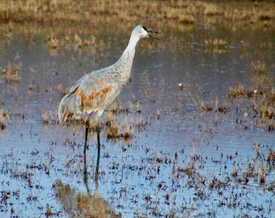
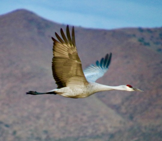
A sandhill crane catches early morning sun on its wings at the Bosque Del Apache NWR. (Photo by Peggy Mekemson.)
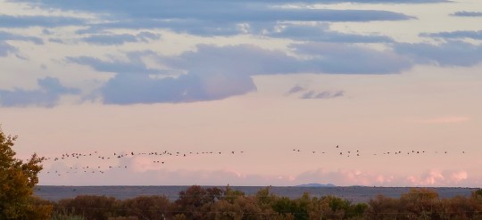
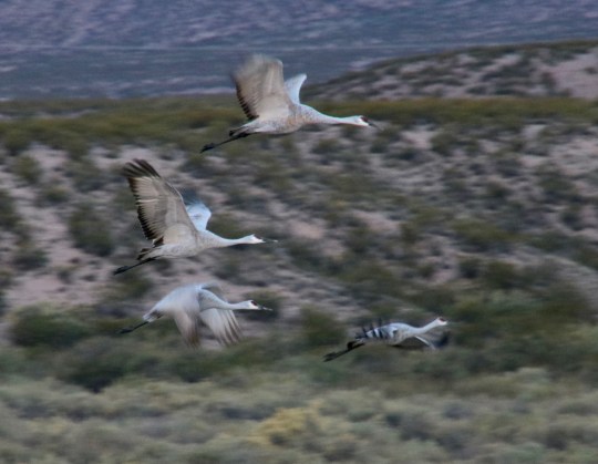
Necks straight out with feet trailing, hundreds of sandhill cranes took to the sky as they began their early morning launch in search of food in the middle Rio Grande Valley of New Mexico. Later in November, their numbers will be climbing to the thousands at the Bosque Del Apache National Wildlife Reserve just south of Socorro. We had watched long lines of the cranes flying back to the reserve the night before, burbling away in long lines, and were eager to witness the phenomena.
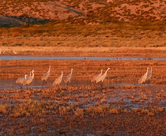
The night before, we had watched long lines of sandhill cranes flying into the reserve after a day of feeding along the Rio Grande. Enlarging this photo, I counted close to a hundred cranes in this picture alone.Even when the sky seemed empty, we could hear the burbling, almost magical call of the cranes.In addition to the wildlife, we were attracted to the beauty of the area. This windmill caught my attention.As did this tree outlined by the setting sun.The nearby Rio Grande River decorated by fall colors. (Photo by Peggy Mekemson.)
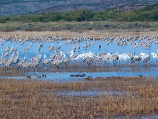
The owner of the RV campground that sits on the edge of the reserve told us we should be at the observation point about a mile from our campground by 6:30 a.m. to witness the early morning action. Peggy and I made it, barely, and jumped out of the RV into the icy air without coats, hats, or gloves to witness one of nature’s greatest shows. Numerous much smaller Ross’s geese joined the party while shoveler ducks ignored all of the hullaballoo and went about their business of eating breakfast.
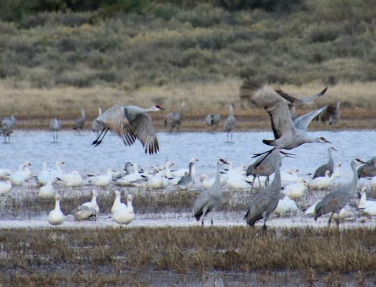
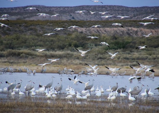
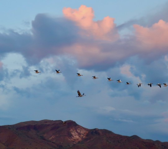
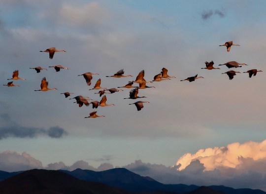
We were greeted by shoveler ducks, sandhill cranes, Ross and snow geese, and more sandhill cranes. While my camera lacks the close-up capabilities of Peggy’s telephoto lens, it was capable of showing quantity!Peggy provide a much closer perspective on the sandhill cranes. Note how most of them are facing forward, which is the direction they will soon be flying. (Photo by Peggy Mekemson.)The light changed rapidly from 6:30 to 7:00. The cranes are all moving forward, long legs stretched out. (Photo by Peggy Mekemson.)We watched as the cranes took flight, using their powerful wings to thrust them into the air. The geese seem to have decided to let the cranes clear out first. (Photo by Peggy Mekemson.)In fact, the geese didn’t quite get the program and were landing instead of taking off. They would soon join the cranes in flying off, however. (Photo by Peggy Mekemson.)I caught this photo just as the sun hit the reserve, turning the remaining cranes gold.A wider perspective of the reserve caught in the early morning light.Peggy thought that this cottonwood was a nice addition to the scenery. (Photo by Peggy Mekemson.)Looking down the length of the preserve.This fellow seems to be saying, “Hey, where did everyone go? Was it something I said?” (Photo by Peggy Mekemson.)The true thrill of the morning was catching the birds in flight. Again Peggy’s telephoto lens was best suited for this. The following photos are taken by her.The one in front is chatting.Even my Canon Powershot could catch the silhouettes!And I was pleased with how I caught this sandhill crane with a line of Ross’s geese above the mountain.And this flock of sandhill cranes caught in the sunlight.Peggy was fascinated with how the sandhill cranes bunched up, apparently working out leadership issues. (grin)I’ll conclude with this shot of geese flying out at sunrise. (Photo by Peggy Mekemson.)
NEXT POST: Peggy and I will visit Taos where Georgia O’Keefe began her long association with New Mexico.
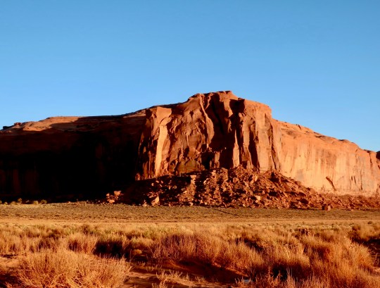
We expected to find impressive stone monuments in Monument Valley and weren’t disappointed. A convenient stump added to the magic of this scene. Many a Hollywood star ranging from John Wayne to Johnny Depp saddled up here and made Westerns.
Peggy and I are sitting in our van on the edge of the Bosque Del Apache National Wildlife Reserve on the Rio Grande River in central New Mexico. It’s supposed to be a major winter gathering place for numerous species of waterfowl, even the close to extinct whooping crane. We are watching as sandhill cranes return to the reserve in long lines after a day feeding along the river. At least a thousand have flown by so far.
We were greeted by a road runner when we came into the campground. The owner told us to watch out for wild pigs. I wonder if he meant peccaries. They are nastier than pigs and come with razor sharp tusks, great for rooting up food— or doing serious damage to pesky tourists. Here piggy, piggy, piggy. We saw lots of fresh tracks this morning when we were hiking up a desert wash near Los Lunas looking for petroglyphs, but there were no peccaries.
Other than the train that just roared by and the sound of sandhill cranes settling in for the night, it seems extraordinarily quiet here. If you travel 30 miles due east from where we are, however, you come on the Trinity site where the first atomic bomb was blown up on July 16, 1945, forever changing the world. A bit farther east, Smokey the Bear was discovered in a tree hiding out from a wildfire in 1950, and Billy the Kid practiced his fast-gun draws in the Lincoln County War of 1878. Continue on and you come to Roswell where UFO fans will forever declare that flying saucers crashed in 1947 and the government hid the fact. Traveling the opposite direction into the Rockies some 60 miles, the Very Large Array of radio telescopes searches the skies for alien life and other astronomical wonders. Lots has happened in this quiet place.
I rode my bike through here in 1989 as part of my 10,000-mile bike trek around North America. I crossed the Rockies in one day, bicycling 100 miles. If that seems a bit daunting, like it did to me at the time, the second 50-miles were all downhill. Woohoo!
We have just completed a delightful few days of exploring Taos, Abiquiu and Ghost Ranch following in the footsteps of Georgia O’Keefe and her friend Ansel Adams. It should make a fun blog. But that is all in the future. Today I want to share a few of the photos we took at the Hubble Trading Post, Canyon De Chelly and at Monument Valley. (Written a few days ago.)
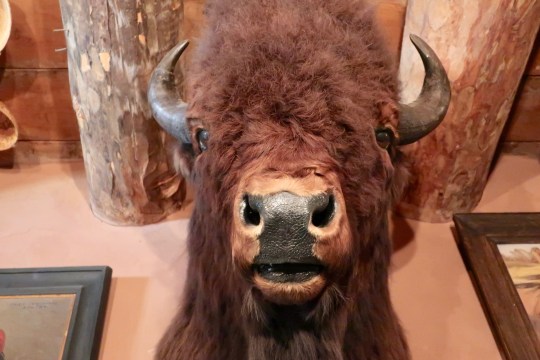
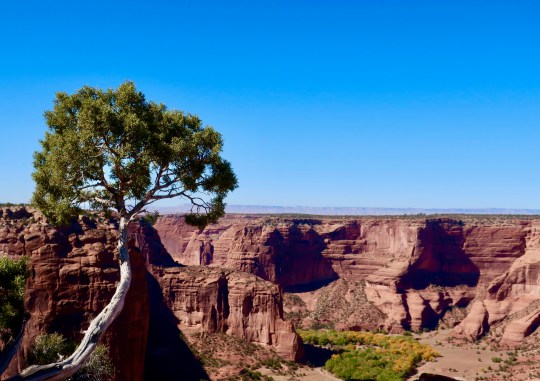
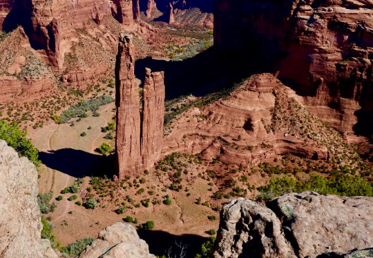
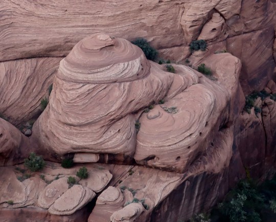
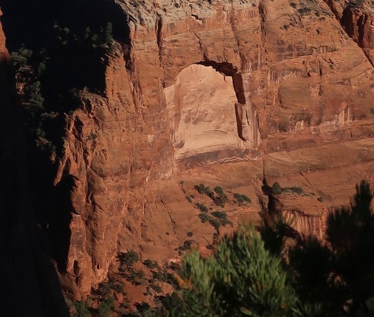
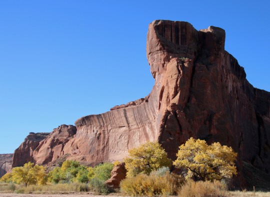
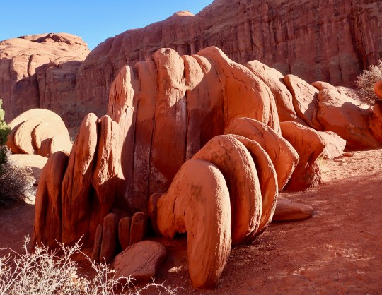
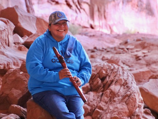
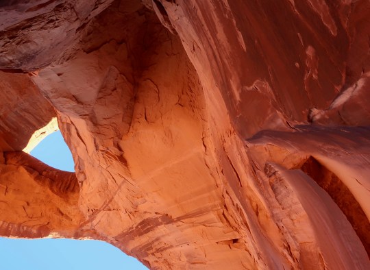
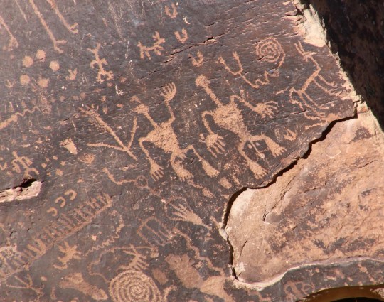
Sheep are important to the Navajos, both for their wool and meat. This four horned fellow, looking down his nose at me, decorated the walls of the Hubble Trading Post. He was joined by…A buffalo and…A magnificent elk.Hubble provided the Navaho with a means of making a living by encouraging them to make rugs and then buying them to sell. I was amused to find this one in his home, which is now part of the National Monument. The face reminded us of petroglyphs that are found throughout the Southwest, which we will feature in a later post.Rugs continue to be made and sold at the post in the traditional way.A view inside the Hubble Trading Post, which is still open for business and looks very much like it did a hundred years ago. We bought post cards to send to the grandkids.Navajo made baskets cover the ceiling of the Hubble Trading Post.We left the Hubble Trading Post and drove on to the Canyon de Chelly (pronounced shay) National Monument which is jointly operated by the Navajo Nation and the National Park Service. We were driving along the south rim of the Canyon when we came on a herd of handsome Navaho sheep. (Photo by Peggy Mekemson.)Visitors are welcome to drive along both the South and North rim of the National Monument. Several overlooks provide gorgeous views into the Canyon. Fall cottonwoods added a splash of color. Navajo still live in and farm the canyon.A number of ancient cliff dwellings are also found in the Canyon. (Photo by Peggy Mekemson.)As might be expected, prominent landmarks are incorporated into Navajo mythology and beliefs. The monument is Spider Woman.The power of erosion on various types of rocks creates marvelous land forms in the canyon. Check out the face on the right!Shamans of Native American tribes were known for the other-worldly journeys they took. Peggy and I thought this eroded rock looked like a window or door into such a world. Stare at it for a few minutes and you may see other beings looking out at you. Grin. (Photo by Peggy Mekemson.)As we returned to our campground, we were treated to a sunset that lit up the canyon walls.If you wish to journey into Canyon de Chelly, you have to have a Navajo guide. I highly recommend the experience. While you can appreciate the beauty from the rim, being inside provides a totally different perspective! (Photo by Peggy Mekemson.)Even the well traveled tracks that your guide takes you over provide a unique look.The views in the canyon went on and on, enhanced by the fall colors as they were from the rim.We visited a number of petroglyph sites. The fellow lying down is Kokopelli, known for his mischief and playing his flute, which he used to seduce women. (Photo by Peggy Mekemson.)Our guide, James Yazzie Jr., added considerably to the enjoyment of our experience. In addition to being a guide, he was a horse rancher, welder, Native dancer, and movie extra. His grandfather had been a ‘Navajo Talker’ during World War II.Monument Valley is also part of the Navajo Nation like Canyon de Chelly and once again we went on a Navajo guided tour. This monument is a beauty but somehow I couldn’t help but think of Rowan and Martin’s Fickle Finger of Fate award. Those of you who were around will probably remember the award that was given out weekly on the TV show. (Photo by Peggy Mekemson.)My imagination jumped to petrified Tyrannosaurus Rex claws when I saw these rocks!While I was focusing on ‘Rex’s claws,” Peggy captured these rocks in their golden setting. (Photo by Peggy Mekemson>)Monuments come in many sizes and shapes in Monument Valley.Peggy and I both took photos of this monument reaching for the sky.Our tour took us to the appropriately named “Big Hogan.” One of our tour group provided a perspective on just how big it is. The hole in the “Hogan” was quite colorful. (Photo by Peggy Mekemson.)Our guide, Roz, broke out her flute and played while we were admiring the ceiling of the “Hogan.” It was quite haunting. Kokopelli would have been jealous. (Photo by Peggy Mekemson.)I found the “Eye of the Sun” rock very dramatic.I am not sure the Ancients who created petroglyphs had a sense of humor, but I often find their petroglyphs humorous. This was in the Big Hogan and Eye of the Sun area.I’ll conclude this post with a view of the sunset in Monument Valley. (Photo by Peggy Mekemson.)
NEXT POST: The New Mexico world of Georgia O’Keefe and Ansel Adams.
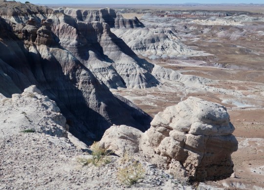
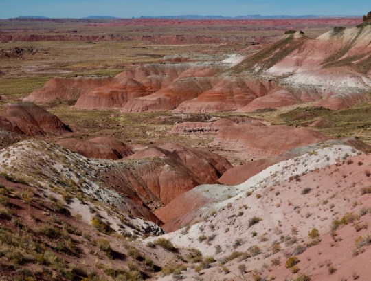
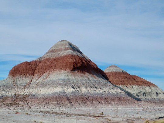
They called them Badlands. Early settlers couldn’t farm or ranch them, so what good were they? In time, however, people would come to see their beauty. This is a photo taken from the Blue Mesa in Petrified Forest National Park. One reason I liked it was because the outcrop on the right resembles an early American. (Or possibly George Washington on a bad day? Maybe he was off to a rocky start.)
Note: I wrote this post over several days as we wander through the Southwest. We are now between Santa Fe and Taos, New Mexico— and the temperatures are still freezing!
It’s snowing outside and icy cold. The windchill factor is pushing the temperature to around O degrees F (17.7 C). Quivera the Van is not happy. I bought chains for her yesterday with the fervent hope that I won’t have to use them. I’ll do almost anything to avoid that nasty chore. Right now, that suggests heading south, even if it means skipping Mesa Verde National Park where we were going today. Getting there involves climbing up steep mountain roads that are now obscured by dark, threatening clouds. We aren’t terribly disappointed. We’ve already been there twice and we’ve seen a number of Anasazi ruins perched on cliffs over the past week (although not as impressive as Mesa Verde).
Even heading south from Colorado into New Mexico won’t avoid the freezing temperatures. A record-breaking blast of arctic air reaches all the way to the Mexican Border.
In my last post I shared a few of Peggy’s Grand Canyon photos. From there we went to Flagstaff, Arizona where we bought a new iPhone for Peggy and house battery for Quivera. Peggy was holding her warped, 6-year-old iPhone together with a plastic clip. The house battery was refusing to last longer than a few hours. While Peggy was busy playing with her new toy, I was left out in the cold changing the battery. It wasn’t hard. I just had to make sure that the positive and negative cables were hooked up to the right posts. But I tend to regard fixing things mechanical right up there with putting chains on in a freezing snowstorm. The good news is that I didn’t electrocute myself or burn up Quivera. More to the point, we now have power when we aren’t hooked up to electricity. I was quite proud of myself. Peggy was amazed.
Here’s Peggy with her clipped together iPhone. It really was time to buy a new one.
Flagstaff is a pleasant town with good restaurants and bookstores. It is nestled at the base of the San Francisco Mountains that are regarded as sacred by a number of Native American tribes in the area. Kachinas (Navajo spirits) are said to wander the mountains and do bad things to folks who find themselves lost up there, especially in snowstorms. I once spent a week by myself camping and hiking on the 12,000-foot Humphreys peak which is part of the range. I was quite careful. It isn’t smart to irritate a Kachina.
Our son Tony and his wife Cammie spent some time living in Flagstaff while he was flying tourists by helicopter over the Grand Canyon and into the Havasupai Indian Reservation down inside the Canyon. He flew Peggy and me into the reservation like the former multi-tour Marine pilot he was and put on the theme to Star Wars for inspiration. Imagination runs wild in this family.
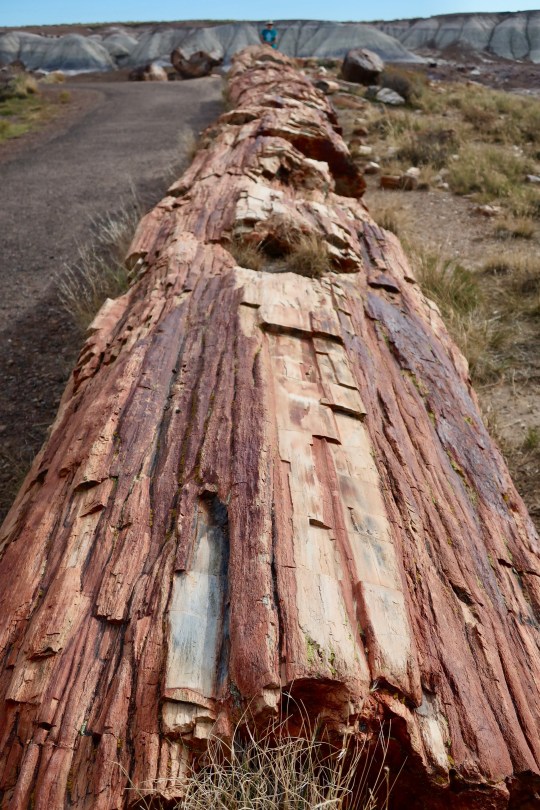
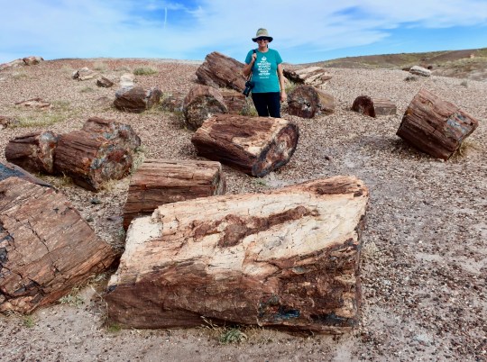
Most of the areas we have visited so far on our Southwest journey deserve blogs on their own and will get them. For now, here is a sample of the photos Peggy and I have taken over the last few days of the incredibly beautiful and often intriguing Southwest. For example, have you ever sat on a hundred foot petrified tree? Think of these pictures as hors d’oeuvres. The main course and dessert will come later. Today I am going to feature Walnut Canyon National Monument, the Painted Desert, and the Petrified Forest National Park.
If you look way down toward the end of this 100 foot petrified tree, you will see a tiny me straddling the log. It wasn’t the softest seat I have ever had. (Photo by Peggy Mekemson.)
Walnut Canyon National Monument is a few miles east of Flagstaff, Arizona just off of Interstate 40. I’ve passed by it a dozen times over the years on my way somewhere else and never stopped. I was always curious, however. Peggy and I made it a priority, this time.
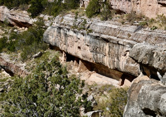
What I didn’t realize was that Walnut Canyon features cliff dwellings of the ancient Anasazi people of the Southwest who made their homes here around 1100-1200 CE. (Photo by Peggy Mekemson.)The varying erosion rates of different limestones provided a convenient shelf for the Anasazi to build their homes complete with ceilings and floors. By following the shelf around the canyon you can see a number of more homes. (Photo by Peggy Mekemson.)Peggy and I climbed down 273 steps to reach the cliff dwellings. This is a view of Walnut Canyon. below where the cliff dwellings were located. Trees added a bit of fall color.We were amused at this sign located at the head of the stairs going into the canyon.Here, I am sitting inside of one of the dwellings. This was more likely a storage room where things like water would be stored in large jars. The Anasazi had to climb down the steep walls of the canyon to fetch water. During the dry season, they had to store enough to last up to 100 days. (Photo by Peggy Mekemson.)This provides a view of a larger room that could accommodate a family. Weather permitting, it is assumed that people were outside a good deal of the time.A number of families might share a section of cliff in Walnut Canyon as this picture demonstrates. (Photo by Peggy Mekemson.)We had a pleasant walk along the trail while we were checking out the cliff dwellings. Then it was time to climb back up the 273 steps! Another visitor slipped into this picture. (Photo by Peggy Mekemson.)
A hundred miles east of Walnut Canyon on I-40 we came to the Petrified Forest National Park. The road takes you through the Painted Desert, which is part of the Park. As we drove in, we were greeted by a raven. They seemed to be following us around. We’d met several up at the Grand Canyon. Actually, they gather where there are tourists, hoping for a hand out.
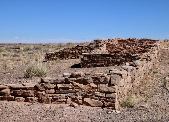
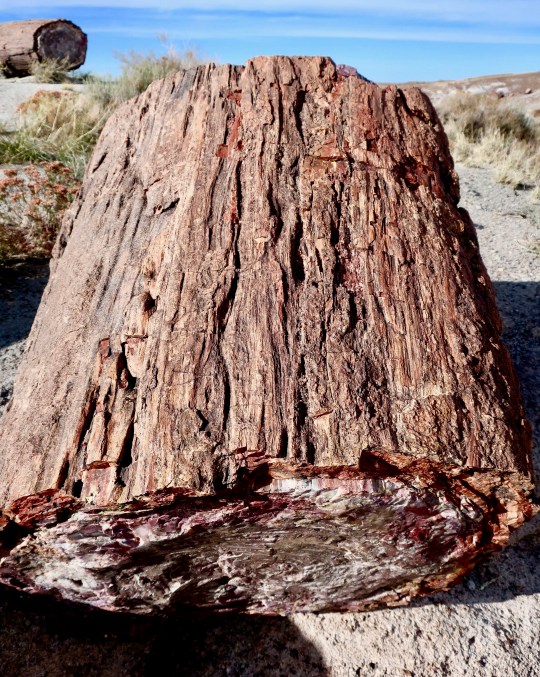
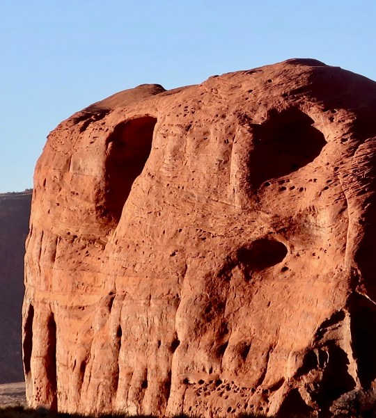
Ravens are clever birds. Had this guy figured out to wait where people had to stop? Plus he was doing what the Grand Canyon ravens do: Provide a photo-op and expect payment in food. I told him “No snacks” and he flew away in disgust, croaking a Poe-like “Never more!”I took this photo of the Painted Desert in the morning about 11:00 as we were driving into the Park.When we came back through in the afternoon, there was more color but still not as rich as it would be at sunset.The Petrified Forest National Park is the only national park that historic Route 66 passed through. This 1932 Studebaker in the park commemorates the highway.Ancient Americans also made their home in the Petrified Forest National Park. This one is known as the Puerco Pueblo since it is located along the Puerco River. (Photo by Peggy Mekemson.)Peggy caught these cottonwoods growing near the Puerco Pueblo, a tell-tale sign of water in desert country.We consider finding and photographing petroglyphs something of a hobby. This one of a large bird with a frog speared on its beak is almost iconic. It was located along with a number of others next to the Puerco Pueblo. (Photo by Peggy Mekemson.)This rather charming couple that caught our attention was found just down the road from the Puerco Pueblo on what is known as Newspaper Rock. (There are other newspaper rocks.) I also liked the skinny coyote off to the right. He reminded me of Wiley Coyote about to take off after Road Runner. Known as the Teepees for their structure, the various colors represent different environments down through the ages from deserts, to seas, to rivers and tropical forests.Driving off of the main road and up onto the Blue Mesa in the Park is a real treat. Seeing massive petrified logs resting on rocks would be reason enough to make the detour. A dry wash works its way off into the desert. (Photo by Peggy Mekemson.)I was captured by the beauty and unusual land formations of the area.Peggy and I followed a trail off of the Blue Mesa and into the canyon where I took a photo of her hiking for perspective. She was hoofing it. Peggy has always hiked fast and I don’t see any sign of her 69 years slowing her down!Peggy found this stump of petrified wood on our hike that provided a shark contrast to the blue grey of the canyon.I always enjoy slipping in a black and white rendition of a photo on my posts. This one was from the rim of the Blue Mesa looking down into the valley that Peggy and I hiked through.People primarily come to Petrified National Forest to see the petrified wood. No surprise there. And they aren’t disappointed. It is everywhere and in large quantities as this photo with Peggy demonstrates.This photo provides another perspective of how much petrified wood there is in the park. We were along a trail that leads through what is called the Crystal Forest. (Photo by Peggy Mekemson.)I was fascinated how faithfully the the bark was preserved on these ancient trees from millions of years ago.I’ll use this final photo by Peggy to wrap up our visit to the Petrified Forest National Park for now. The natural way that petrified wood splits provides beautiful views of the inner wood. And every one is different! We have several photos to prove it.
NEXT POST: I will feature photos from our trips into Canyon De Chelly and Monument Valley. And since I am finishing this post on Halloween, I decided to post this photo I took in Monument Valley.
I thought this monument looked skull-like enough to make it into my Halloween collection of rocks. Hope you enjoyed your ghostly encounters.
The incredible beauty of the Grand Canyon combined with its geological history and opportunity for adventure have pulled Peggy and me back time and time again. (Photo by Peggy Mekemson.)
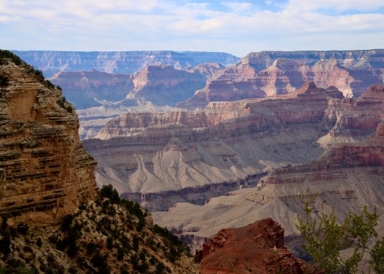
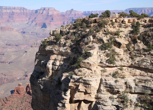
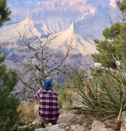
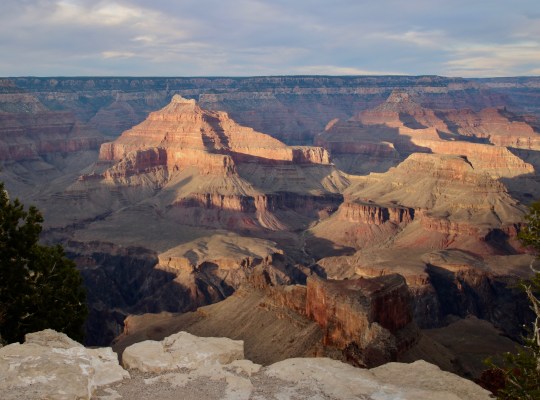
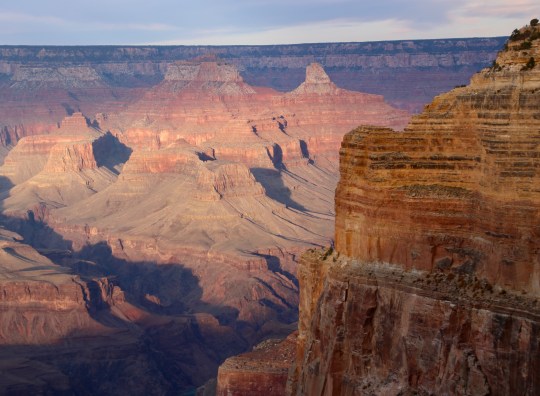
Peggy and I are now finishing up the first week of our Southwest tour and I decided it was time to give you a taste of things to come. Today, I am featuring photos by Peggy that she took on Saturday. All of these are from overlooks along the West Rim Drive between the Grand Canyon Village and Hermit’s Rest. Peggy is using our EOS Rebel T6i with its 16-300 Tamron telephoto lens.
We arrived at our campground in the park around one pm on Saturday and immediately set off to catch the shuttle bus out to Hermit’s rest. The West Rim drive is closed to autos. The bus makes several stops at key overlooks. Visitors are free to get off the bus, hang around as long as they want, and then catch another bus. They run every 10-15 minutes. We took the bus out to Powell Point and then hiked the Rim Trail to Mojave Point. There, we caught another bus out to Hermit’s Rest. After that we took a bus back to Mojave Point for sunset.
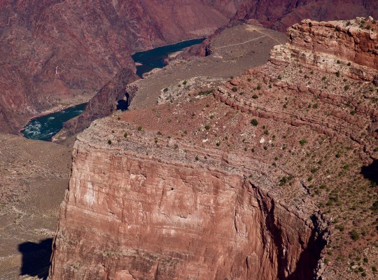
Well, most of the photos are by Peggy. (grin) This is not a selfie. Here she is sitting up on the memorial at Powell Point. I am using our Canon Power Shot G9X, the camera I took with me when I hiked down the PCT last year. While it lacks the lens and capabilities of our Canon Rebel, it still does a credible job.This is looking back at Powell Point from along the Rim Trail. You can see the memorial on top and the tiny people checking out the views. (Photo by Peggy Mekemson.)I have never seen a view of the Grand Canyon that isn’t scenic. (Photo by Peggy Mekemson.)We often include trees to to add variety to our photos. (Photo by Peggy Mekemson.)And since Peggy is taking the photos, I often end up in the tree shots. (Photo by Peggy Mekemson.)Turn about is fair play, of course.This ridge made it into several of our photos because of its dramatic color. (Photo by Peggy Mekemson.)In addition to the grand views one gets by looking across the canyon, there are always interesting sights looking down. It’s good to avoid getting too close to the edge! Several people fall off every year taking selfies of themselves while standing as close as they can get. (Photo by Peggy Mekemson.)This photo was of interest because of four things. One, it shows the massive Red Wall that makes its way all around the canyon. Two, the dark spot you see in the Red Wall was where a condor was spotted. Three, the trail you see in the distance, marks my first ever trip into the Canyon. I rode down on a mule and was sore for days after. Finally, you can see the Colorado River. Peggy and I did an 18 day raft trip down it several years ago. (Photo by Peggy Mekemson.)Out at Hermit’s Rest, Peggy took a photo of me taking a photo. Can you guess what I am taking a picture of? (Photo by Peggy Mekemson.)Here’s what I was capturing.Back at Mojave Point, the sun was preparing to set. Note the tower to the left. (Photo by Peggy Mekemson.)It turns from a reddish orange… (Photo by Peggy Mekemson.)To a deeper red. (Photo by Peggy Mekemson.)The rock outcrop on the right also caught our attention with its deep golden color.. (Photo by Peggy Mekemson.)I’ll conclude with Peggy’s photo of the outcrop as darkness fell across the Canyon while the sun caught it full on, creating a magical moment. (Photo by Peggy Mekemson.)
NEXT POSTS: As you might imagine, we have much more on the Canyon and will be doing future posts as part of our National Park series. For now, we will provide snippets of our journey as we move along.
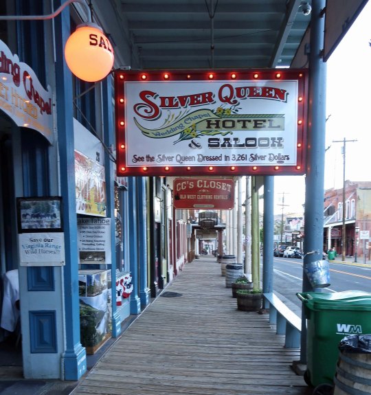
Board sidewalks in Virginia City, Nevada that once kept the town’s residents out of the dirt, dust, horse poop and mud, now add an element of charm and authenticity to the old west town whose silver fortunes helped make Nevada a state and build San Francisco. The sign promised you could “See the Silver Queen dressed in 3,261 Silver Dollars.”
“To find a petrified man, or break a stranger’s leg, or cave an imaginary mine, or discover some dead Indians in a Gold Hill tunnel, or massacre a family at Dutch Nick’s, were feats and calamities that we never hesitated about devising when the public needed matters of thrilling interest for breakfast. The seemingly tranquil Enterprise office was a ghastly factory of slaughter, mutilation and general destruction in those days.” Mark Twain on his creative days of writing “fake news” as a reporter for the “Territorial Enterprise” in Virginia City during the 1860s.
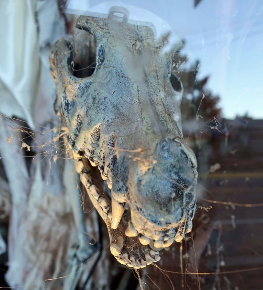
Twain took full advantage of people’s fascination with macabre as a journalist in Virginia City, creating events if the news of the day was boring. I wondered what he would have made of this woman’s skull I found staring out at me from one of the shops. I arbitrarily decided he would whip out a tale about a love affair gone wrong. Sex and murder are bound to draw the reader’s attention. Then I saw another skull in the window and decided the woman was yelling…BAD DOG!I suspect that Twain would have made an interesting story out of this Virginia City coach as well. My thought is that he would have tied it in to how long you had to wait to cross the main street that was clogged with ore carrying wagons.
Quivera, our 21 foot RV, was whining again as I drove her up the curvy, steep Geiger Grade to Virginia City from Highway 395. “Stop complaining,” I told her, “or we will go explore more four-wheel drive dirt roads.” She piped down immediately.
The town is perched on the edge of Mt. Davidson at an elevation of 6, 140 feet, providing dramatic views of the surrounding country.
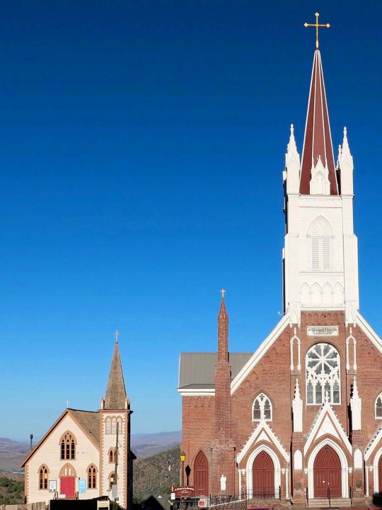
The hills behind the picaresque St. Paul’s Episcopal Church in Virginia City seem to stretch off into infinity.Another view of distant vistas. This one includes Sugarloaf Mountain. Dozens of mines once climbed up the slopes and spread throughout the Six Mile Canyon that stretches through this area.
It all started with a gold rush in 1859. There was a lot, but it was mixed in with a chunky black rock that resisted being separated from the gold. As it turns out, the dark rock was silver ore and it was much more plentiful than the gold. The ore was part of the famed Comstock Lode, the first major silver strike in the US. It was a strike that would create several millionaires, help fund the building of San Francisco, provide the North with much needed cash during the Civil War, serve as an impetus for creating the state of Nevada, and lead to the founding of Virginia City.
Samuel Clemens arrived in Carson City, Nevada by stage coach in 1861 with his brother Orion who had been awarded a plum position as secretary to the Territorial Governor of Nevada. Orion had earned his appointment by working in Abe Lincoln’s campaign for President. He invited his brother along to serve as his own secretary. Samuel found the job a bit tame for his creative imagination, however, especially given all the ‘get rich quick’ schemes that were floating around in the West. His first effort was to run a logging operation at the still wild Lake Tahoe. Lumber was in high demand. That adventure ended with his campfire escaping and burning down the trees he planned to log— plus a substantial part of the surrounding forests. He then decided he would try his luck mining for gold and silver, an effort that had similar results for him, except he didn’t burn down any more forests.
The Territorial Enterprise newspaper out of Virginia City saved Clemens from his life of toil in 1862. It also provided him with his life-long calling. The editor had been impressed with several ‘letters to the editor’ he had written and invited him to write for the paper and serve as city editor in Virginia City. He was soon earning an impressive forty dollars a week and had taken on a pen name, Mark Twain. As he notes in Roughing It, his delightful book about his adventures in the West, he rarely took his pay. He didn’t need to. Reporting was a profitable business. There were hundreds of wildcat mines that stood little chance of making a profit. Not to worry. Miners would select a snazzy name and then print up fancy stock. A favorable article in the newspaper would almost guarantee that the stock could then be sold for hundreds, if not thousands of dollars. Miners lined up eagerly at Twain’s door hoping for positive articles and paying him in stock to assure that the article was written. Forty dollars a week was chump change.
Twain remained in Virginia City from 1862 to 1864 before heading west into California. Virginia City continued to grow and prosper into the late 1870s reaching a population of some 25,000 people. A massive fire wiped out the town in 1875 but it was rebuilt within a year. Most of the historical buildings found in Virginia City today are from the post-fire era. There are some beauties!
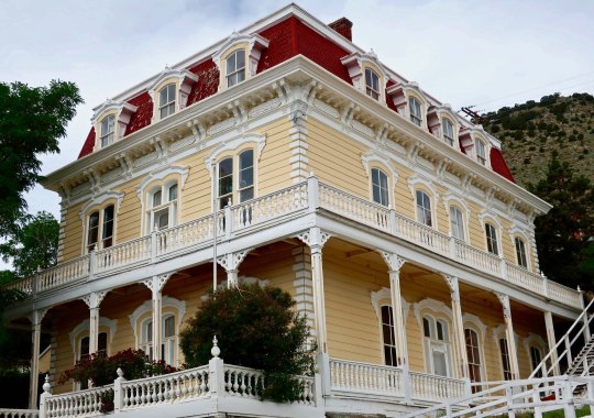
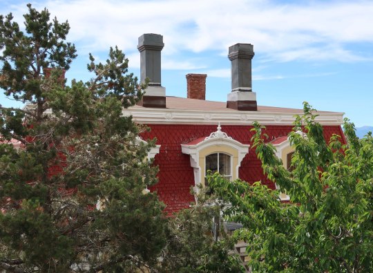
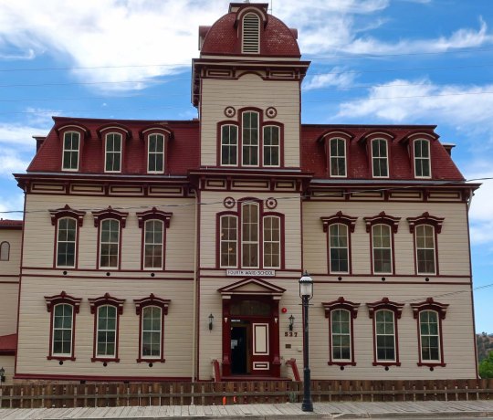
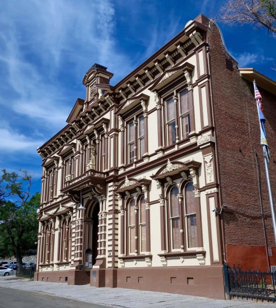
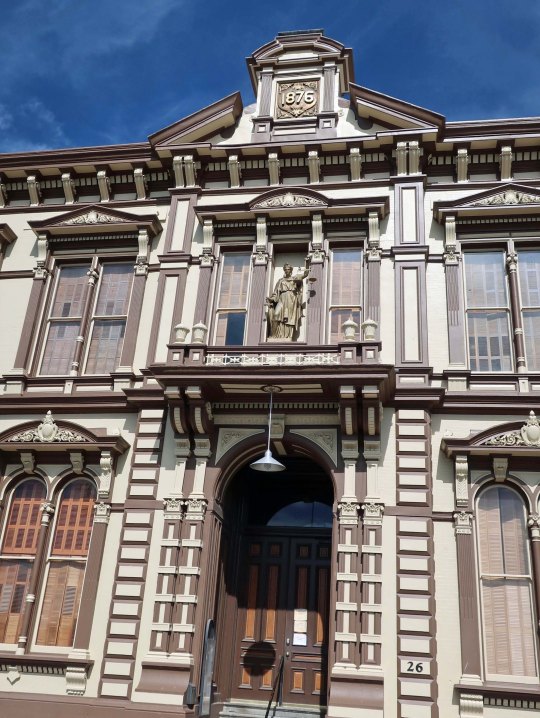
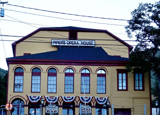
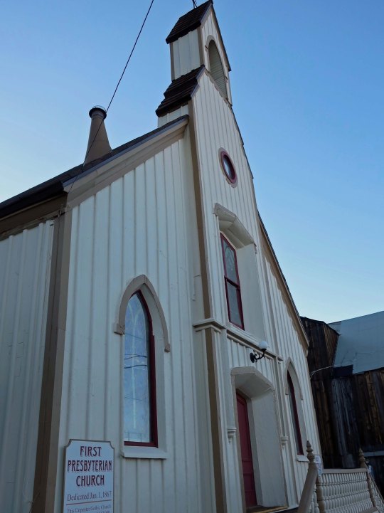
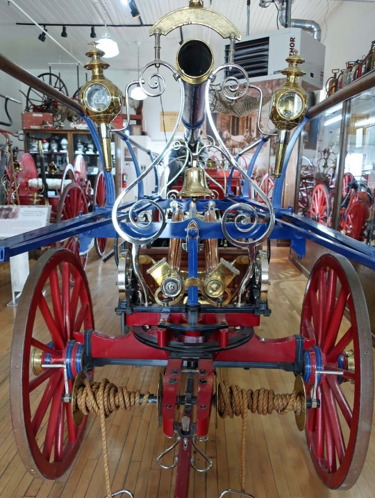
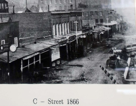
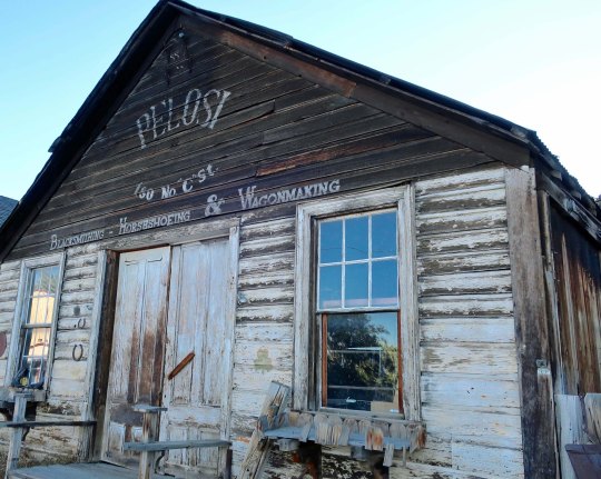
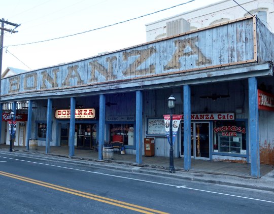
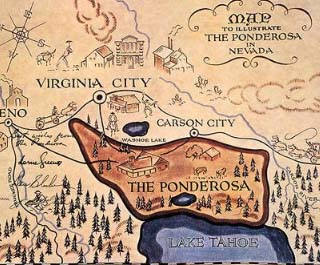
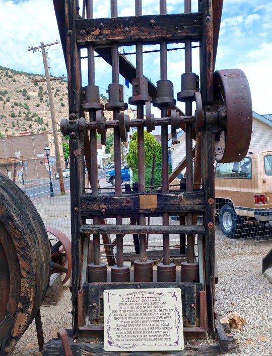
The Victorian Savage Mansion served as both a home and office for the Savage Mine. President Ulysses S. Grant gave a speech from the second floor balcony. The town’s main street runs above the house.This is what the mansion looks like from above.The Forth Ward School was a symbol of pride for Virginia City. Capable of holding over a thousand students, it utilized modern education techniques such as team teaching.A side view of the Forth Ward School. It now serves as a museum. A major mine was located across the street.This early photo of the Choller pit mine and the Fourth Ward School.The Storey County Court House is another attractive building found in Virginia City.A front view with the building date prominently displayed. A sign on the front door reported that DMV was closed on Friday. One other note: Justice is blind, right. Not here, she can see. Justice looked down on the streets of Virginia City and likely saw more than she wanted to.The Piper Opera House is just down the road from the courthouse. I have always been intrigued by the number of early western boomtowns that featured opera houses.This Presbyterian Church was one of the few buildings to survive the 1875 fire.Both the imposing St. Mary’s in the Mountains Catholic Church and its smaller cousin, St. Paul’s Episcopal Church, had to be rebuilt after the fire.While we are talking fires, this was one of the early firehouses in Virginia City. It is now a museum housing various fire fighting equipment.Such as this fancy fire truck. Apparently looks were as important, and possibly more so, than fire fighting capability.I don’t know what this building was in its earlier life, but I found it appealing.Another view of the building. It was up the steep hill from my RV campground. Just about everything in Virginia City is up or down a steep hill! The bright blue house behind the Jeweler’s shop made a fun contrast. Any visit to Virginia City calls for a leisurely stroll up and down C Street, the towns main drag. This is what it looked like in 1866 before the fire caused it to be rebuilt.Then, as now, the city had its fair share of saloons and then some! The Bucket of Blood Saloon refers to the buckets of water that had to be used each night to clean up the blood left behind by fighting miners. Inside the Bucket of Blood Saloon today. I was impressed by the saloon’s expensive look. Photos of early Virginia City were featured beneath the bar. The one you can see featured a V&T train.A mural in the center of town also features the Virginia and Truckee Railroad. Built in the 1870s, the railroad carried millions of dollars worth of gold ore to Carson City and Reno. Rebuilt in 1974, the V&T now carries tourist from Virginia City to nearby Gold Hill or farther afield to Carson City in ornate cars pulled by vintage steam and diesel engines. All aboard!The mural, which definitely needs some loving care, also featured the Piper Opera House, a dancing girl, and what I assume were stained glass windows from one of the churches.Continuing my stroll along C Street, I found this blacksmith shop.The Crystal Bar.The Red Dog Saloon. An upstairs windows offered painless dentistry. These were pre-novocaine days. I wondered how much booze would be required. Law offices offered ‘acquittals in most cases.’ A room was one dollar. For another dollar you could have a bath that came with an attendant. Did he/she wash your back?This bar looked intriguing. I was tempted but 10 AM is a little early for me.A building that apparently came without a saloon.And another.Some amusing signs I found along C Street.And my favorite.I couldn’t help but think of the TV series. In fact, Virginia City owes a lot to Bonanza. It was the go-to town for the Cartwrights. People who enjoyed the immensely popular series became interested in seeing the town, which gave Virginia City a substantial boost in tourism during its 14th season, 431 episode run.The well-know map of the umpteen thousand acre Ponderosa that kicked off each episode of Bonanza. (Mark Twain’s fire, BTW, would have burned a portion of the Ponderosa had it been for real. The Cartwright family would have been after his hide.)Virginia City’s most famous Madame, Julia Bulette, was even included in an episode of Bonanza. Little Joe falls in love with her and Ben disapproves, a natural reaction for a dad when your son falls in love with a lady of the evening. When Julia helps save numerous lives, which she did in real life, Ben relents. The Number 1 hat on the left was given to Julia by the town’s firemen who considered her a hero and a friend.Any post about Virginia City should include something about the silver and gold mines. These are mine tailings. Mines were located almost everywhere, including under the city.You hear a lot about stamp mills when you visit the early mining towns of the west such as Virginia City and Bodie. Here is the device that gives the mills their name. The steel booted rods act like pistons rising and falling to crush ore that is fed into a pan at the bottom. You can imagine the infernal noise created. Mark Twain worked feeding one of these machines. It was his job to use a sledgehammer to break up larger pieces of ore to throw into the pan. He lasted for a whole week and earned ten dollars for his 12 hour a day, six day a week job. Mining is dangerous work. These square-set timbers developed for mining in Virginia City made it safer by providing more protection from cave-ins.The mines reached a depth of over 3,000 feet, creating further challenges. One was keeping ahead of the underground water that constantly threatened to flood the shafts. The other was dealing with heat. As the depths increased, the temperature of the geo-thermal water increased. Falling in meant being scalded to death. Ambient temperatures in the mines reached up to 130 degrees F. One solution to the water problem was the Sutro Tunnel that was built at a painstaking pace of 3.2 inches per hour for approximately four miles and allowed up to four million gallons of water a day to be drained. The cart above was used by miners working on the tunnel.I’ll finish my post with this view of a quiet day in Virginia City. If big crowds and lots of excitement are your thing, you might want to visit on the Fourth of July, as the sign recommends— or time travel back to the 1860s and 70s!
NEXT POST: We will journey up to Reno and visit one of the world’s most impressive auto museums— and see some really classy autos.
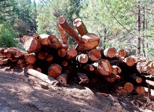
I never expected to see a logging truck coming down our road but thanks to drought brought on by global warming, we had 43 trees to remove!
It’s time for a quick break from my Highway 395 series to bring you up to date on current events in our never-boring life such as a logging operation in our backyard. I’ll be back to Highway 395 and Virginia City in my next post.A note on photos: Peggy and I shared photographer’s duties on this post.
Removing 43 Douglas firs from our five acres was not anything Peggy and I looked forward to, either from an aesthetic or financial perspective. Global warming didn’t give us a choice. Severe drought weakened a number of our trees and voracious pine beetles took quick advantage of the situation. We decided to be proactive in hopes of slowing down or stopping the beetles.
I am no stranger to logging operations. My father was the electrician for a lumber mill when I was growing up. We considered the mill with its logging pond as part of our extended play area, much to the dismay of the nighttime and weekend watchman. He had an extensive vocabulary of swear words that he liked to share with us. We even had a logger with his logging truck living next door. He’d wake us up at 5:00 a.m. on summer mornings as he dashed off to collect his first load of logs. Since then, my backpacking trips have occasionally taken me through areas that were being logged.
None of this is anything like having a logging operation in your backyard, however. I didn’t actually hear anyone shouting “Timber!” but the buzzing sound of chainsaws accompanied by the crashing sounds of large Douglas firs (some over a hundred feet in length) was our constant companion for a week.
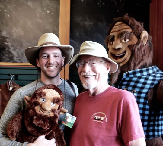
Peggy hiked up and took photos of the logs being hauled out of the forest…We watched as the logs stacked up in our backyard.And then were loaded onto a truck. (There were two loads.) Check out the claw!This large claw, designed to grasp logs and load them on to the truck, was operated from the front of the truck by the owner, Davron Holland.We waved goodby to our trees as they were hauled away.Speaking of claws, all of the commotion disturbed the forest spirits that live in our canyon. Peggy and I came home one day to find our hammock being shredded!Was it the same creature that left this mark?It appears that its claws were of an appropriate length. Could it be the legendary Bigfoot?Not likely. My nephew Jay Dallen and I check out a Bigfoot family at Crater Lake National Park. They hardly seem the type to rip up a hammock… (Jay, you may remember, backpacked a hundred miles with me last summer on my 750 mile trek down the PCT.)Maybe Bone was having a bad day. My blogging friend, Crystal Truelove, took him up to the Bigfoot trap to show him what it feels like to be locked up. But Bone is good friends with Crystal. She took him back for a visit to the Cherokee Nation in Oklahoma this past year and he got to hang out with Cherokee princesses.Also, he had a photo shoot with Jay’s actress friend, Nichole Tompkins…And was feeling quite balanced!This fellow at Crater Lake was a possibility. I refused to feed him a peanut, but a) his claws were too small and b) Nichole shared a PB&J sandwich with him.This buffalo we found in Al the Wop’s Bar in Locke, California last week had the right horns but his unique eyeshade eliminated him.This Stellar Jay was unhappy enough to take on the challenge. He was hot! But again, his claws weren’t up to the job.We found several possible candidates on our road trip through the redwoods where we found the claw marks. But they were too far away.Maybe it was an irritated buck with an attitude problem. This was my prime candidate with his “Are you looking at me!” pose. Turns out, it was a fellow that hangs out with him, a young spike with two small but sharp horns who was suffering from severe antler envy. He was using the hammock to clean the velvet off his antlers.
And Other Events…
My niece Marion and her husband John. They had come out from Tennessee to collect my brother’s 32 foot RV that he had left in my backyard when he passed away. It was big! We were glad to see it go. Next was a visit from a fellow blogger, Crystal Trulove. As most of you are aware, the friendships that evolve from our blogging are special. Crystal was in town for the Shakespeare Festival in Ashland and stayed at our house. She treated us to the wonderfully whacky play, “Alice in Wonderland.” The African cloth in the background, BTW, was sent to me by another good blogging friend, Linda Leinen at Shoreacres. Linda and I share a common background of having lived in Liberia, West Africa.We had a delightful visit with Jay and Nichole. Here we are at a Beach Boys Concert at the Britt in Jacksonville, OR.We took Jay and Nichole to our favorite kayaking spot, the Bigfoot trap, and…to Crater Lake National Park. Here Peggy and Nichole share a look. (I am not sure it is possible to work more blue into a photo.)Jay offers a piggy back ride! On our way home from Crater Lake, we were treated to this sunset in the Applegate Valley. When Jay and Nichole left, Jay was heading off to film a National Geographic reality adventure show across Russia and Nichole was heading for Barcelona where she has a film opening.We went on a short road trip through the redwoods. They’re big.Until the national and state parks were created to save the redwoods, they were rapidly being cut down. My seat is an old stump.And note the burls! I will be doing a much more extensive post on Redwood National Park (and Crater Lake) as part of my national park series.We ended up visiting my old friend Tom Lovering who lives on the Sacramento Delta with his friend Lita in the town of Clarksburg. I was backpacking with Tom in 1977 when we found Bone. Tom immediately loaded us into his ski boat to head off for an Italian dinner.When Tom got the boat up to full throttle, he climbed out of the seat and insisted that I take over, which was a bit scary considering I had never steered a speed boat! Woohoo! “Watch out for big logs,” he told me. Yeah, thanks.Peggy with Tom’s friend Lita in the back of the boat, not nearly as worried as they should be.Coming back from the restaurant we were treated to a beautiful Sacramento Delta sunset.Afterwards, Tom and Lita took us on a tour of the Delta and we ended up at Al the Wops Bar in Locke. You’ve already met the buffalo who lives at the bar.The deer were also decorated. One can only wonder how many drinks it takes.If that seems a bit risqué, you can always feed the fishOr practice the popular pastime of sticking dollars to the ceiling.The friendly bartender taught me the trick! And, I am proud to report, I succeeded.Locke when we left the bar. I can count on one hand the number of times I have ‘shut the bar down’ in my life. And I am pretty sure that Tom has been in on all of those occasions.
NEXT POST: I return to my Highway 395 series and visit Virginia City where silver was king and Samuel Clemens adopted the name of Mark Twain.
This old International truck in Bodie is retired, a ghostly reminder of what it once was.
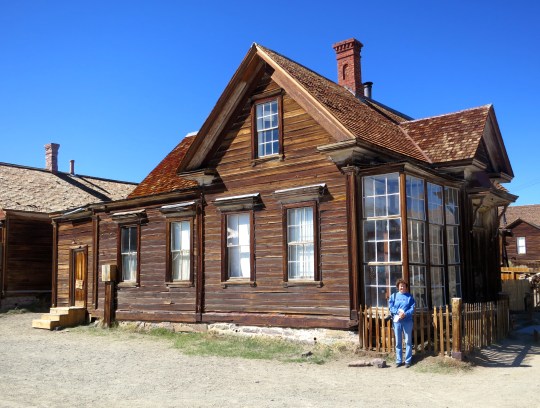
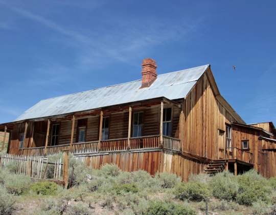
We can thank James Stuart Cain for the fact that the ghost town of Bodie, located 13 miles off of California’s Highway 395, is something more than a few derelict buildings sinking into the ground. Cain arrived in Bodie in 1879 as a young man of 25 with a new wife and towering ambitions. He began his rise to being Bodie’s number one citizen by importing lumber across Mono Lake to build the town’s mines, businesses and homes. He would go on to own the town’s bank and the Standard Mill. Eventually he would own most of the town, which he and his family would love and take care of— an effort that included hiring on-site security. When he passed away in the late 1930s, his family continued to maintain the vacant town and security right up until the time they passed it over to California in 1962 for a state park.
I took this photo of Cain’s home on an earlier visit to Bodie when my wife Peggy (standing in front of the house) was with me.
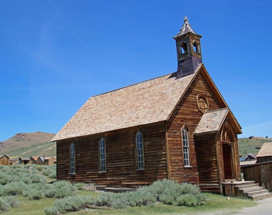
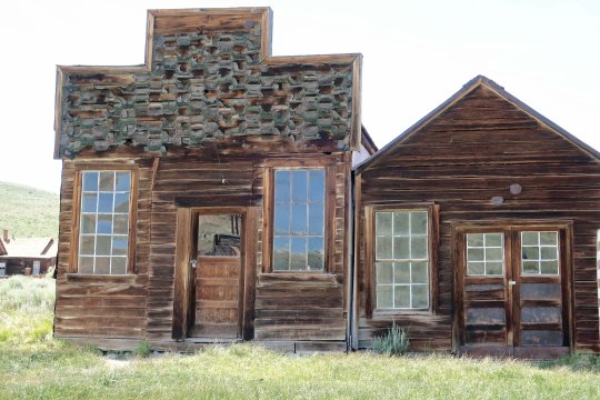
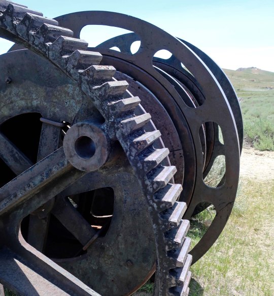
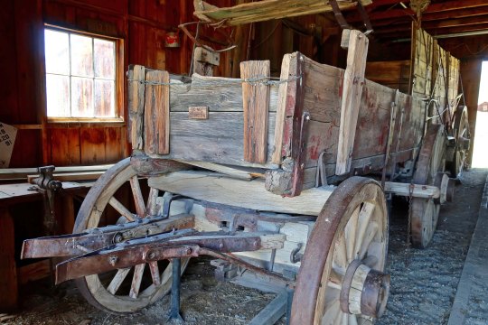
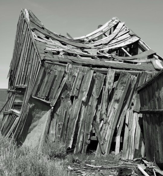
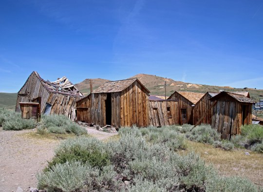
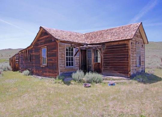
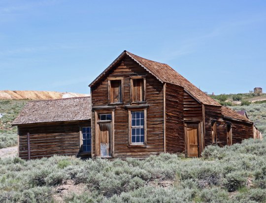
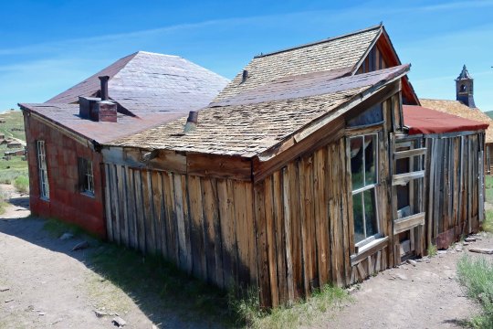
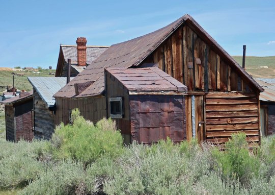
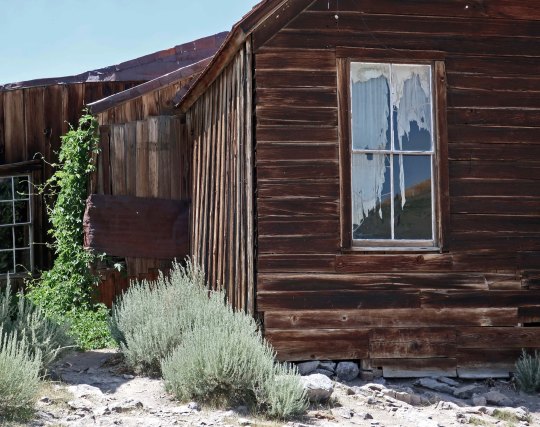
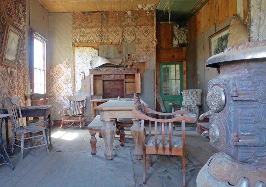
I featured Bodie’s ghostly homes in my first post. Today I will feature other buildings that remain standing in the town, vehicles in various stages of ‘arrested decay’ and mining machinery.
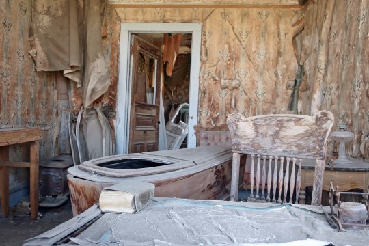
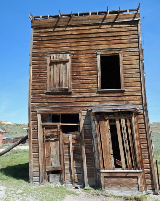
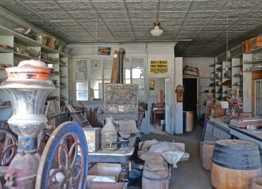
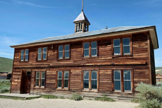
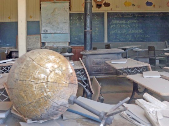
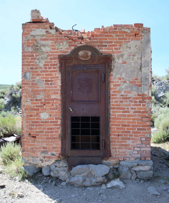
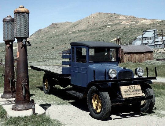
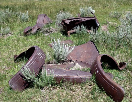
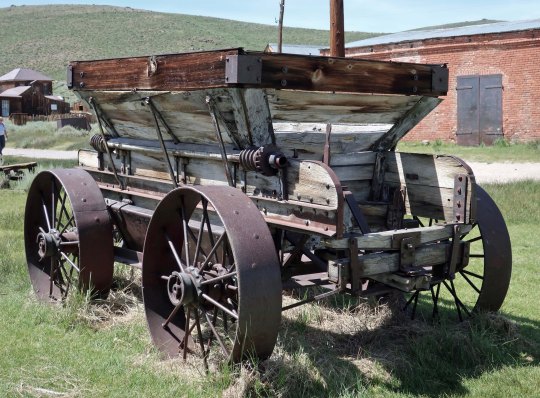
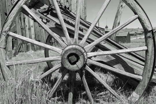
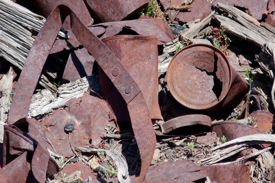
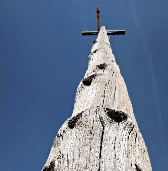
The Methodist Church, peering out here from behind several homes, is one of Bodie’s most attractive building.A closer look at the Methodist Church.One of my favorite ‘perspective’ photos from Bodie.A look inside the Methodist Church— it comes with a fun story. Can you name the Seventh Commandment? Did “Thou shall not steal” instantly leap into your mind? (Or did you have to look it up like I did.) Anyway, a copy of the Ten Commandments once hung in the blank space at the front to the church. And, as you probably guessed, somebody stole it!Okay, it’s time to get back to the ghostly part of Bodie! You are looking in the window of the local mortuary, complete with a casket with a convenient viewing window. I wondered if the book was a how-to-manual for the mortician— either that or Tolstoy’s “War and Peace”— based on how thick it is. I am sure if you stare at the wallpaper long enough, you will see ghosts.Nearby was a hearse that also included a casket. I was assured that the casket was empty. Hmmm. Not sure I would want to be in either place on a dark and stormy night by myself.This is another of Bodie’s iconic buildings where ‘arrested decay’ means propping it up to keep it from falling over! Once upon a time it was a hotel. Rooms should be cheap now.A few shops still stand on Main Street. This is an inside view of a mercantile store that was filled to the brim with a little bit of everything.Shave and a haircut, two bits! And more ghosts in the wallpaper. I am pretty sure that the guy on the right got a bad haircut. The Independent Order of Odd Fellows’ hall. I’ve always found the name “odd fellow” intriguing. The urban dictionary defines it as “a person who acts in a confusing or bizarre manner,” which would fit my idea. My guess is that the English had something else in mind when they founded the fraternal organization in the 1700s. Maybe my followers from England can enlighten me.I liked the unique look of the front of the shop on the left.Early mining towns had a tendency to burn down. Often. Diamond Springs where I grew up, managed it three times. Having a firehouse was important. This is one of three that Bodie once had. My guess is that the other two burned down.The fire trucks. I wouldn’t be overly optimistic when they pulled up in front of my burning house.The schoolhouse. Impressive.An old globe inside the Bodie schoolhouse. When I focused in on the blackboard, I learned that 6-3=2. Somebody had some fun with that.There isn’t much left of Cain’s Bank, another victim of fire. Apparently he had a fireproof safe. Note how many layers of brick there are.I looked inside and found the safe. These ruins were found next door to the safe-house. I assume that they were part of the bank. I walked through the door and looked out.And was treated to a view of the Standard Mill.There were several mills at the height of the gold rush. The Standard Mining Company mill is all that is left at Bodie today.You have to sign up for a special tour of the mill property but I was able to wander around and take photos from the outside.Machinery used in the mining operations can be found throughout the park.Geared up for work!A Shell gas station once provided service at Bodie. I couldn’t help but wonder if some disgruntled miner had shot the sign full of holes when the gas jumped up to $.20 a gallon!Several vehicles in various stages of falling apart are found in Bodie. This 1927 Dodge Graham truck is ‘waiting for gas.’ No doubt it still is.This one is beyond gas.No gas was needed for this old mine cart. You wouldn’t have to worry about flats either. Wonder if you could hook it up to one of the fat cows wandering the property?No gas was needed for this large ore cart either. But it might take the whole herd of cows to pull it. No bull.Besides a ranger— the cows, a few prairie dogs, and these cliff swallows were the only inhabitants of Bodie I could find. I had a strange feeling that someone was watching me, however. Could it be a ghost?Nope.Every old ghost town of the West needs a wagon wheel, so I will close my two posts on Bodie with this one.
NEXT POST: Timber! A one post break from Highway 395. Never-ever did I expect to see logging trucks using my driveway. Plus some other recent happenings at the Mekemson household. After that we will journey back to my road trip and the silver town of Virginia City.
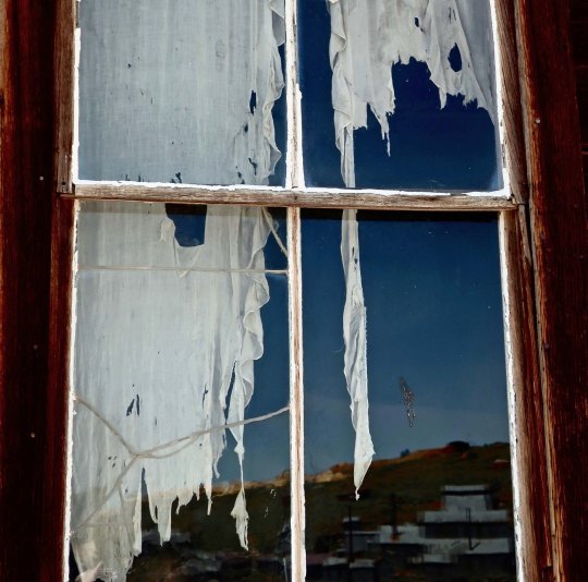
What better way to introduce the ghost town of Bodie than with a ghostly, tattered curtain. The Standard Mining Company mill can be seen in the reflection.
The history of the gold and silver strikes in the Old West of the mid 1800s is one of boom and bust. Large towns of several thousand people would spring up overnight in remote locations and be abandoned almost as fast as veins ran out and other strikes fired the imagination of miners driven by dreams of instant wealth.
Some of the towns have lingered on into modern times. Diamond Springs, where I grew up in the heart of California’s gold country, is one. A 25-pound gold nugget found nearby in the early 1850s assured Diamond of its boomtown status. It was a sleepy, ‘one-horse-town,’ in my youth. Today, it is more like a sprawling suburb. Virginia City, Nevada, which we will visit next on my Highway 395 series, not only survived but worked to maintain its historical look and has become a successful tourist attraction.
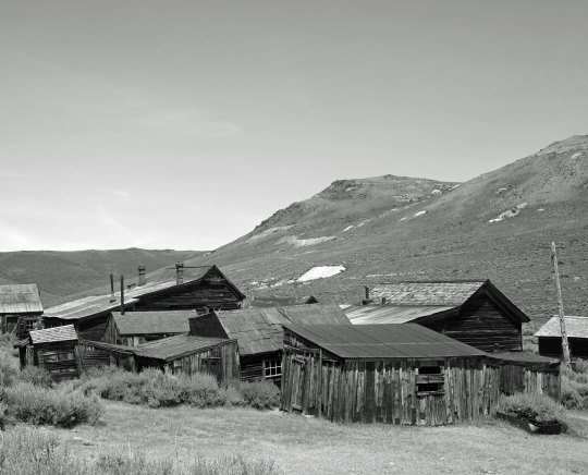
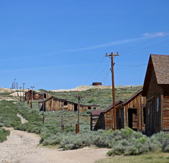
Bodie is another tourist attraction. It has survived as a ghost town, however— in arrested decay as the California State Park staff describes it. Only three people were living there in 1943, the year I was born. That number had plummeted to zero by 1950. (Plummeted being relative, of course.) Gold was first found in 1859 but it was in 1876 when the Standard Company found a profitable gold vein that turned the small camp of a few hard-core miners into a rollicking boomtown of 5-7 thousand people with over 2000 buildings. Sixty-five saloons dominated its mile-long main street. I have learned over the years that the number of saloons is always a mark of pride for Old West towns. (A substantial red-light district is another.)
Bodie was named a National Historic Landmark in 1961and a California State Historical Park in 1962. Today, just over a hundred of its original two thousand buildings remain. I arrived around 1:00 p.m. on my drive down Highway 395 and spent three rather warm hours wandering around checking out the buildings and other historical remnants left behind— and dodging fresh cow pies. There were so many tourists it was hard to get photos without them. But who wants photos of tourists in a ghost town?! I did photograph the free-range cattle, however. Now if only a ghost or two had made an appearance…
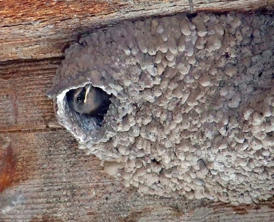
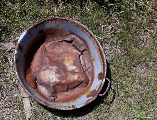
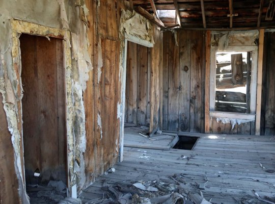
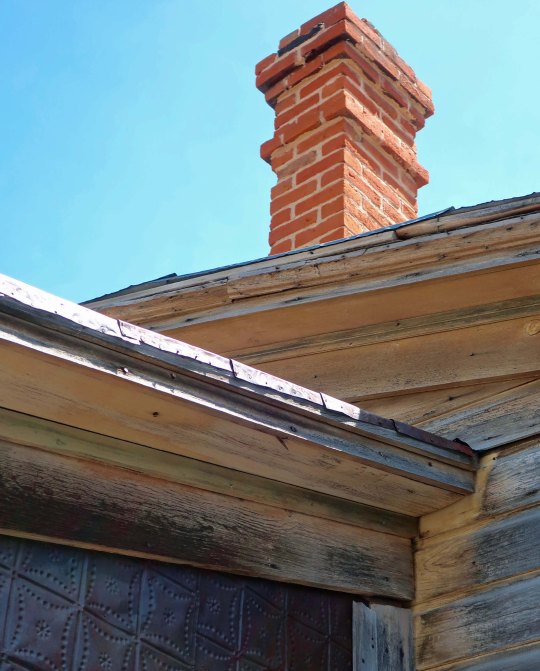
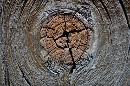
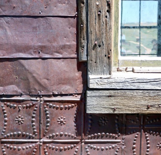
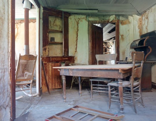
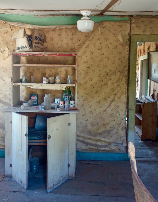
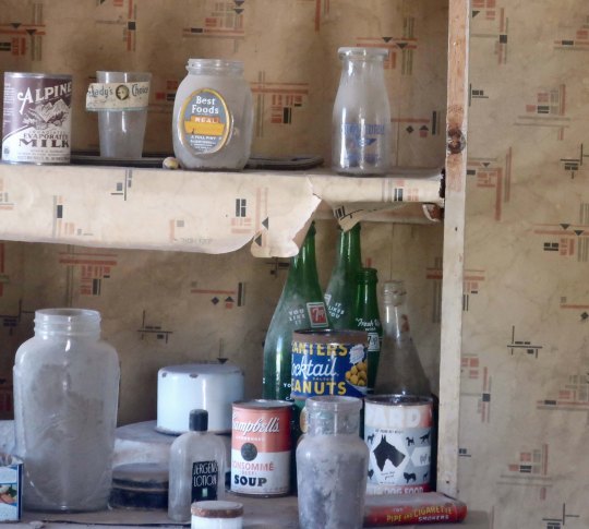
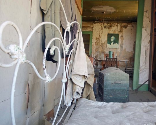
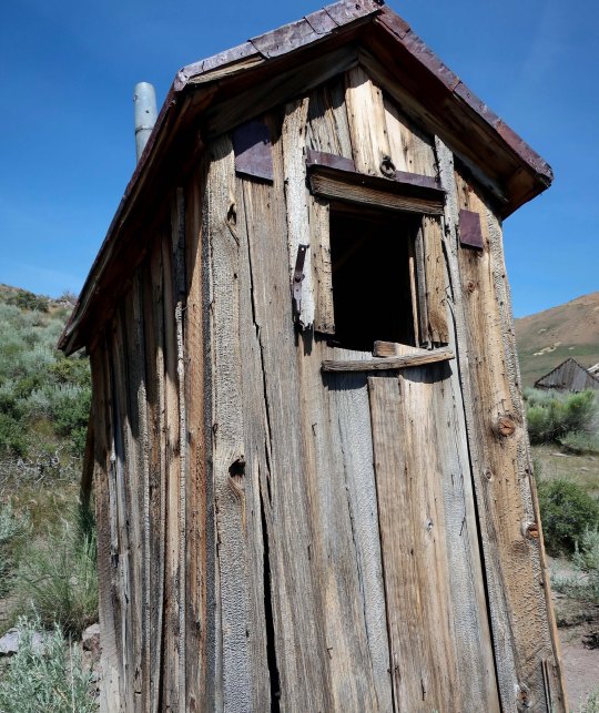
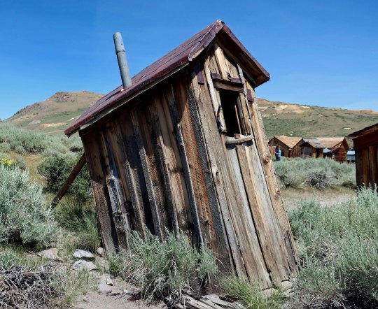
One big Mama and her calf. Free range cattle wander around Bodie like it belongs to them, leaving presents on the ground for tourists.It isn’t that the cattle don’t have other country to roam in. Those are the Sierra Nevada Mountains in the distance. You can see a portion of the 13 mile road coming in to Bodie from Highway 395. The last three miles are dirt. Quivera, our small RV, whined about the wash board road the whole way.My idea of what a ghost town should look like! Not much in the way of ‘arrested decay’ here.The buildings the shack is attached to are more typical of what you find in Bodie, however. Sagebrush is the dominant plant, which speaks to Bodie’s desert environment. Mine tailings can be seen on the distant hills.This house looked almost livable from the outside until you got up close.A blue wash basin was sitting on the ground out front.And a small garbage dump found nearby.It’s looking inside houses that gives you the true feeling of being in a ghost town. Visitors are invited to be ‘peeping toms.’ Most houses look better than this.Here are a few homes to give you an idea of the houses that remain in Bodie.I was fascinated with the roof lines of the houses.And check out the red brick chimney!Weathered wood covers most of the cabins. My camera was attracted to this knot. Once upon a time it would have been a happy limb.Several of the residents had used metal as well as wood to cover their homes.One house had a rather fancy door.Here’s the window with the ghost curtain featured at the top of the post. I think that is a honeysuckle vine on the left.A street view in Bodie shows houses heading up the hill. The power poles are modern.Here’s my choice for a ghost town power pole.Now, let’s take a look inside some of the Bodie homes.You would call the call the cops if you looked out your window and saw this!Some even featured groceries left behind. This one had me checking Google to see if they were around in the 30s. They appeared legit!Best Foods Mayonaise, Planters Peanuts, Campbell Soup and Pard dog food were all around.A pot bellied stove! It gets cold in Bodie during the winter. And check out the dining table.A bed, clothing, a trunk and a print of Gilbert Stuart’s famous painting of George Washington. Stuart painted this for Martha Washington but decided he wanted to keep it and use it for marketing purposes, so he left it unfinished. The painting would become the model for Washington on the dollar bill.Outhouses were common in Bodie. This one came with a view!It could be a little risky using it now, however… Propping up is part of the ‘arrested decay’ program.
NEXT POST: We will continue our exploration of Bodie by checking out some of the commercial buildings that still stand including a ghostly old mortuary with caskets. There are also several abandoned vehicles in various states of decay and some interesting mining machinery left behind.
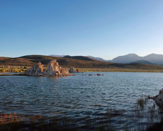
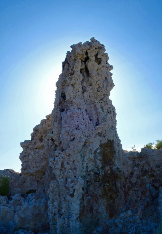
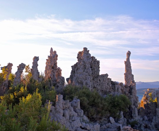
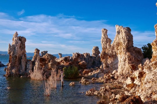
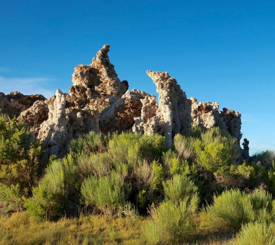
It’s hard to believe that springs bubbling up beneath the surface of Mono Lake were able to create sculptures like the tufa towers you find at Mono Lake.
You’re stuck if you are a raindrop falling into Mono Lake— or anywhere else in the Great Basin. There are no convenient rivers to whisk you away to the sea. Evaporation is your only escape. Water tends to become a little grouchy under these conditions, or make that salty. In fact, Mono Lake is 2.5 times as salty as the ocean, and 100 times as alkaline. The good news here is it is really hard to drown. You can float to your heart’s content. Even sea gulls have a hard time keeping their feet in the water to paddle. The bad news is a minor cut or scrape will send you screaming for the shore.
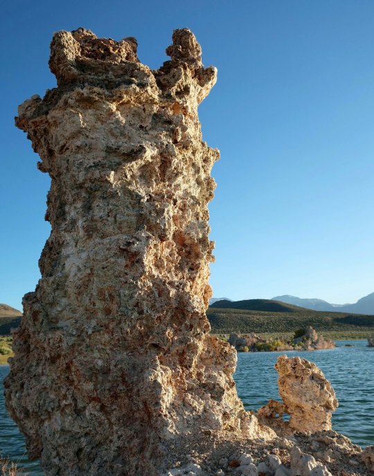
There is magic in the water, however. Springs flowing underground from the surrounding mountains are rich in dissolved calcium. When they bubble up into the lake, the calcium bonds with the carbonates in the lake and together they make rocks, or what are known as tufa towers. In the past, when the lake was full, these towers hid out under the surface and happily continued to grow. There were few or no tufa towers to see. Mark Twain camped out on the lake in the 1860s when he was searching for a lost gold mine and noted in Roughing It,“This solemn, silent, sailess sea— this lonely tenant of the loneliest spot on the earth—is little graced with the picturesque.”
Obviously, the tufa towers weren’t there to greet him. We can thank Los Angeles’s formidable Department of Power and Water for their presence. Back about 1913, DPW had the challenge of supplying more water to the ever-thirsty Los Angeles with its desert environment and burgeoning population. It decided that there was plenty of water up in Owens Valley along the eastern side of Sierras. DPW didn’t bother to ask the local residents, farmers and ranchers whether they wanted their water to go to LA. It didn’t have to. It had the power to grab what it wanted. Things got nasty. Water wars in the West aren’t pretty. “Greed of City Ruins the Owens Valley” the headlines in the Inyo Register screamed. And it wasn’t far from wrong. Every stream of consequence flowing into the valley was tapped to meet LA’s water needs. What lakes that existed started drying up, including Mono Lake. Starting in 1941, DPW began taking water from the lake’s major tributaries, dropping the lake some 40 feet.
Building the pipeline that the LA DPW used to transport water from Owens Valley to LA.Another perspective on the size of the pipeline.Yes, this is me standing in a segment of the pipeline. And no, I wasn’t around when the pipeline was being built.
Environmentalists mounted a major effort starting in the 70s to save the lake. Fish can’t survive in the highly saline/alkaline water, but some four trillion brine shrimp, innumerable small alkali flies, and algae find the conditions perfect. The shrimp and flies, in turn, serve as a major food source for the two million birds that stop off to dine in the lake. The lowering water levels threatened to kill off the algae, shrimp and flies. The birds were in danger of losing their handy fast food restaurant. In 1994, The California Department of Water Resources stepped in to resolve the issue by requiring DPW to reduce the amount of water it was taking from the lake’s streams and repair some of the damage it had done to the riparian habitats along the streams. While the lake won’t return to the levels that existed when Mark Twain visited, the ecosystem is now being protected. Birds will be able to continue to stuff themselves while visitors can continue to enjoy the unique beauty of the tufa towers.
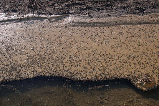
This handsome fellow is a male brine shrimp featured on a signboard at Mono Lake. Length would be about thumbnail size.This provides an idea of how many alkali flies live around the lake.I took this close up as further proof. The flies spend much of their life under water as eggs and pupae. When the adults dive under the water to feed and lay eggs, they travel with a bubble of water. Think scuba diver. Local Native Americans considered the fly eggs to be a delicacy. While I missed the height of bird migration, large flocks were still flying in formation and feeding on the water’s surface.Wilson’s Phalarope stop off at Mono Lake in the midst of a long journey. Mom arrives first in June, leaving Pop at home to finish raising the babies. Pop and kids start arriving later in June and through July raising the total population to around 100,000. The birds are around for 4-6 weeks while they molt and pig out on brine shrimp and alkali flies, doubling in weight. The extra weight is critical for the next segment of their journey: a 3,000-mile nonstop flight to Ecuador.
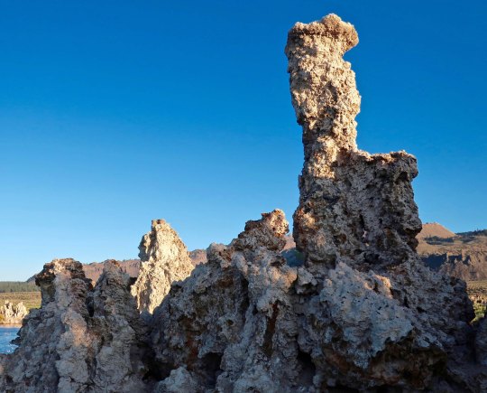
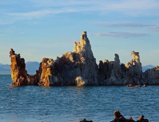
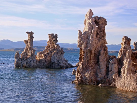
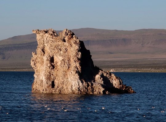
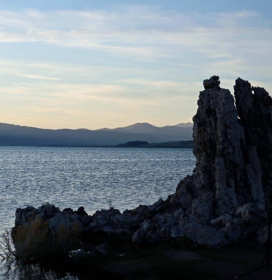
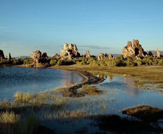
It was late in the afternoon when I visited the south end of the lake where the most impressive tufa towers are found so I was able to photograph the towers at sunset. The warm tones added to the beauty. I took lots of pictures. (Grin) To get here look for the signs that direct you to the South Tufa Towers south of Lee Vining off of Highway 395.
To provide perspective, these are the tufa towers on Mono Lake with the Sierra Nevada mountains in the background. Even without the towers I have a hard time imagining why Twain found the area “little graced with the picturesque.”I divided my photos of the tufa towers into three categories for organization. First up was individual sculptures as shown below.Next, are groupings of the tufa towers.I will finish this series with several photos that place the tufa towers in their broader environment but first I wanted to show this picture I took from the north end of the lake looking south. This would have been more like how Mark Twain saw the lake.I was enamored with this side channel in different light.And took photos from both directions. Here, I caught a sea gull landing.A final view as the sun slipped behind the Sierra Nevada Mountains.