Wandering through Time and Place

Exploring the world with Curtis and Peggy Mekemson
  • About This Blog
  • Bios
  • Chapter from The Bush Devil Ate Sam
  • Five Reasons to Travel
  • Meet Bone: World Traveler, Fearless Adventurer, and Sex Symbol
  • Tag: Mono Lake

    • The Magnificent Tufa Towers of Mono Lake… The Highway 395 Series

      Posted at 11:13 am by Curt Mekemson
      Aug 22nd
      It’s hard to believe that springs bubbling up beneath the surface of Mono Lake were able to create sculptures like the tufa towers you find at Mono Lake.

      You’re stuck if you are a raindrop falling into Mono Lake— or anywhere else in the Great Basin. There are no convenient rivers to whisk you away to the sea. Evaporation is your only escape. Water tends to become a little grouchy under these conditions, or make that salty. In fact, Mono Lake is 2.5 times as salty as the ocean, and 100 times as alkaline. The good news here is it is really hard to drown. You can float to your heart’s content. Even sea gulls have a hard time keeping their feet in the water to paddle. The bad news is a minor cut or scrape will send you screaming for the shore.

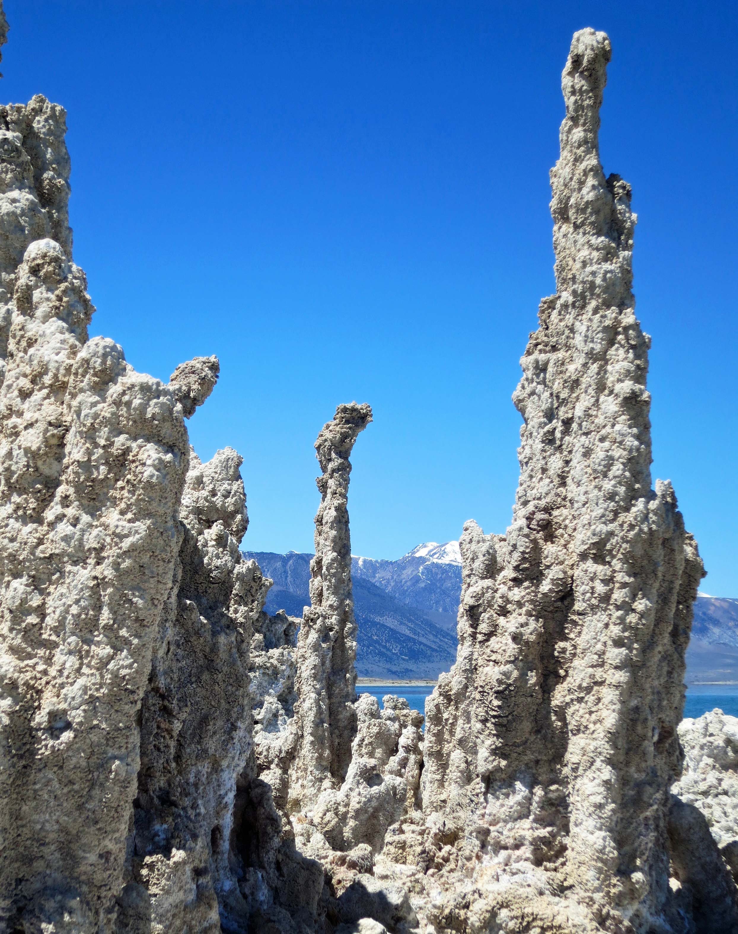
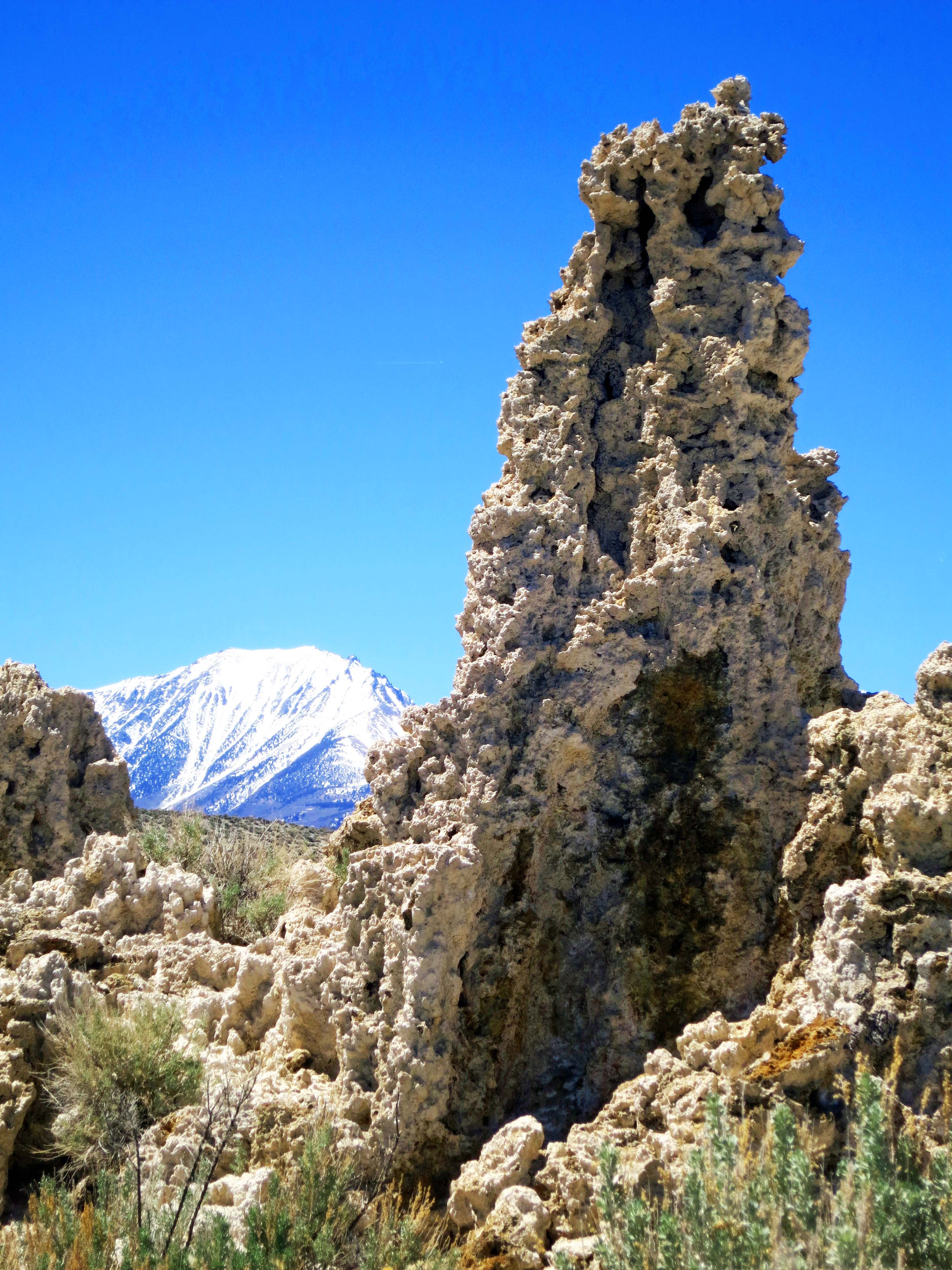
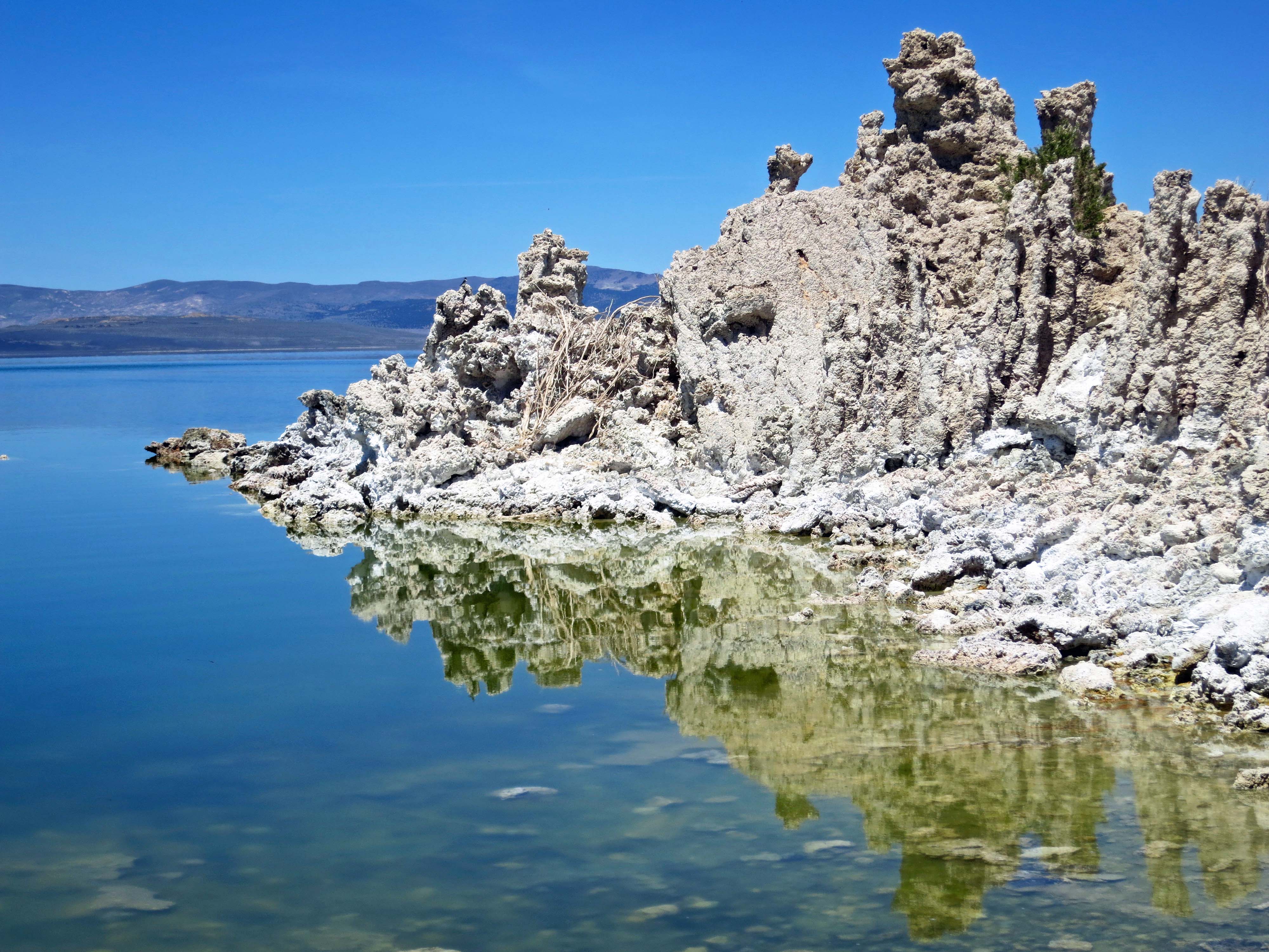
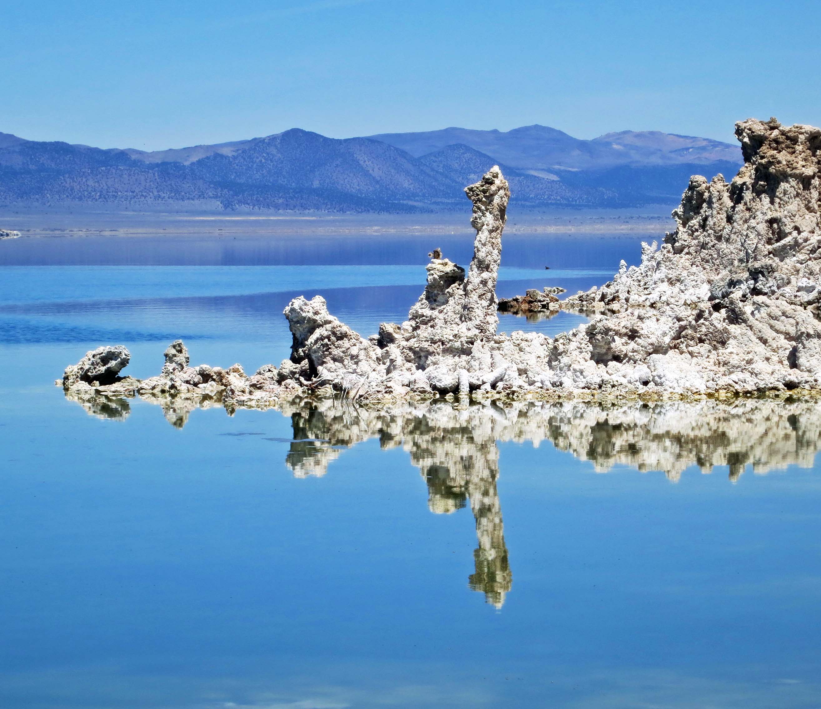
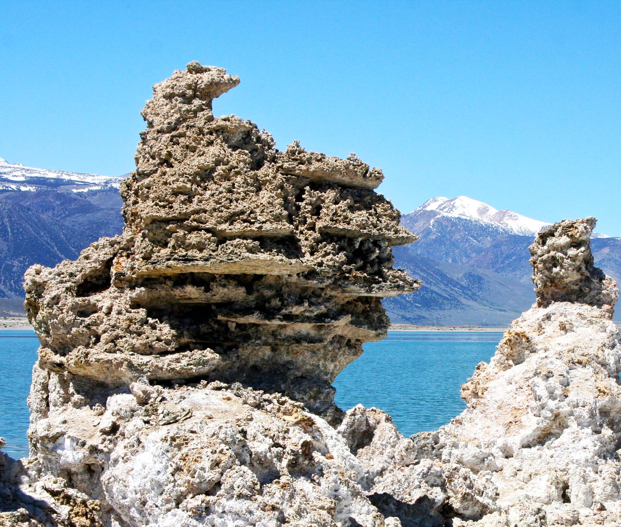
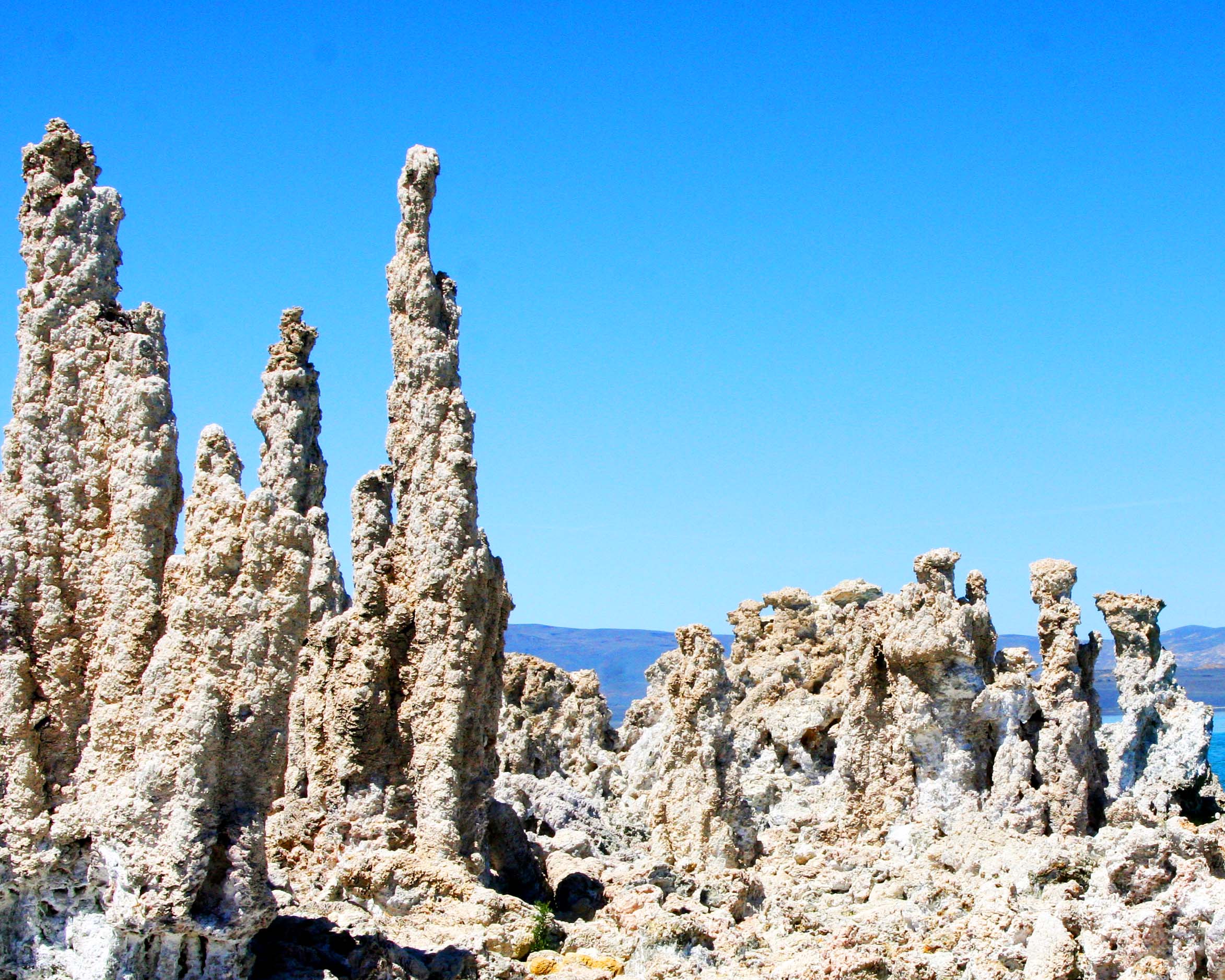
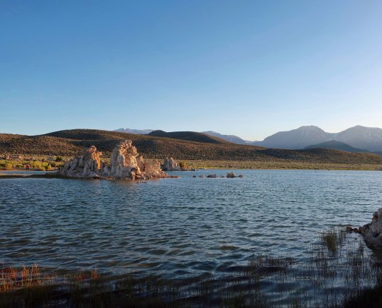
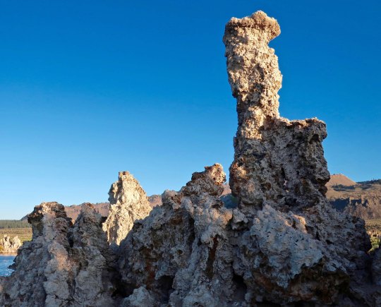
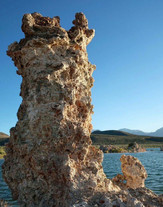
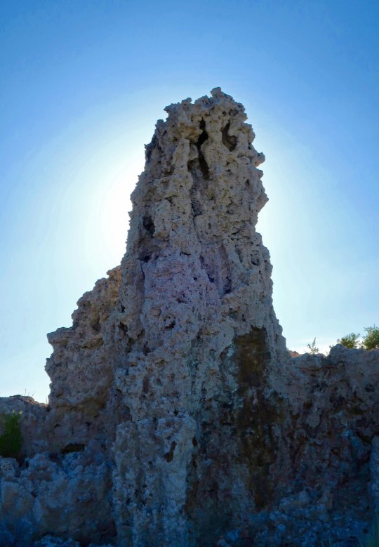
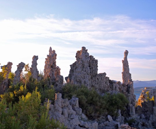
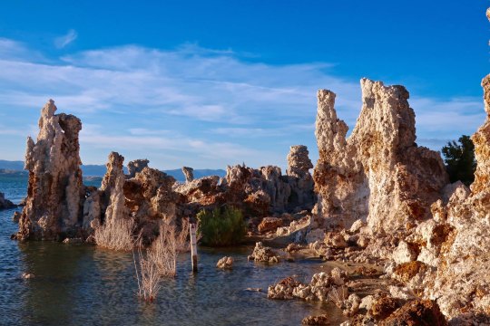
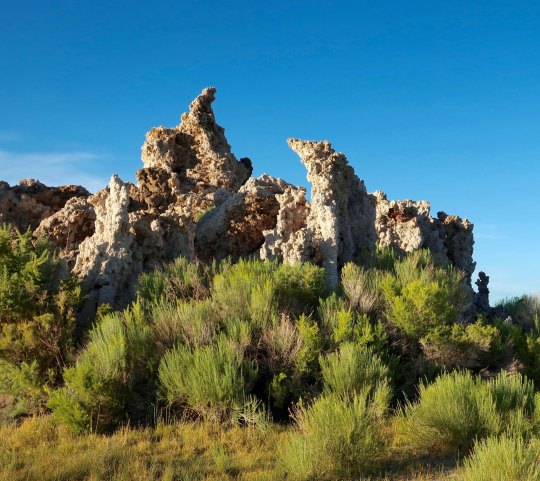
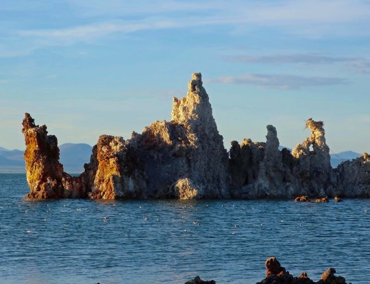
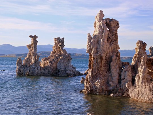
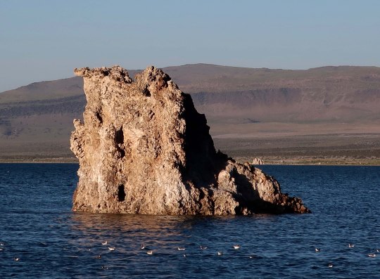
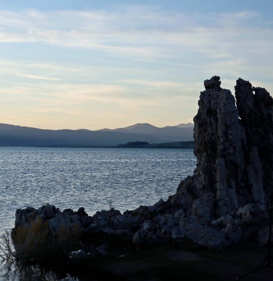
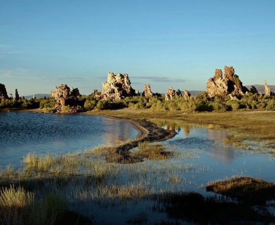
      There is magic in the water, however. Springs flowing underground from the surrounding mountains are rich in dissolved calcium. When they bubble up into the lake, the calcium bonds with the carbonates in the lake and together they make rocks, or what are known as tufa towers. In the past, when the lake was full, these towers hid out under the surface and happily continued to grow.  There were few or no tufa towers to see. Mark Twain camped out on the lake in the 1860s when he was searching for a lost gold mine and noted in Roughing It,“This solemn, silent, sailess sea­­— this lonely tenant of the loneliest spot on the earth—is little graced with the picturesque.”

      Obviously, the tufa towers weren’t there to greet him. We can thank Los Angeles’s formidable Department of Power and Water for their presence. Back about 1913, DPW had the challenge of supplying more water to the ever-thirsty Los Angeles with its desert environment and burgeoning population. It decided that there was plenty of water up in Owens Valley along the eastern side of Sierras. DPW didn’t bother to ask the local residents, farmers and ranchers whether they wanted their water to go to LA. It didn’t have to. It had the power to grab what it wanted. Things got nasty. Water wars in the West aren’t pretty. “Greed of City Ruins the Owens Valley” the headlines in the Inyo Register screamed. And it wasn’t far from wrong. Every stream of consequence flowing into the valley was tapped to meet LA’s water needs. What lakes that existed started drying up, including Mono Lake. Starting in 1941, DPW began taking water from the lake’s major tributaries, dropping the lake some 40 feet.

      Building the pipeline that the LA DPW used to transport water from Owens Valley to LA.
      Another perspective on the size of the pipeline.
      Yes, this is me standing in a segment of the pipeline. And no, I wasn’t around when the pipeline was being built.

      Environmentalists mounted a major effort starting in the 70s to save the lake. Fish can’t survive in the highly saline/alkaline water, but some four trillion brine shrimp, innumerable small alkali flies, and algae find the conditions perfect. The shrimp and flies, in turn, serve as a major food source for the two million birds that stop off to dine in the lake. The lowering water levels threatened to kill off the algae, shrimp and flies. The birds were in danger of losing their handy fast food restaurant. In 1994, The California Department of Water Resources stepped in to resolve the issue by requiring DPW to reduce the amount of water it was taking from the lake’s streams and repair some of the damage it had done to the riparian habitats along the streams. While the lake won’t return to the levels that existed when Mark Twain visited, the ecosystem is now being protected. Birds will be able to continue to stuff themselves while visitors can continue to enjoy the unique beauty of the tufa towers.

      This handsome fellow is a male brine shrimp featured on a signboard at Mono Lake. Length would be about thumbnail size.
      This provides an idea of how many alkali flies live around the lake.
      I took this close up as further proof. The flies spend much of their life under water as eggs and pupae. When the adults dive under the water to feed and lay eggs, they travel with a bubble of water. Think scuba diver. Local Native Americans considered the fly eggs to be a delicacy.
      While I missed the height of bird migration, large flocks were still flying in formation and feeding on the water’s surface.
      Wilson’s Phalarope stop off at Mono Lake in the midst of a long journey. Mom arrives first in June, leaving Pop at home to finish raising the babies. Pop and kids start arriving later in June and through July raising the total population to around 100,000. The birds are around for 4-6 weeks while they molt and pig out on brine shrimp and alkali flies, doubling in weight. The extra weight is critical for the next segment of their journey: a 3,000-mile nonstop flight to Ecuador.

      It was late in the afternoon when I visited the south end of the lake where the most impressive tufa towers are found so I was able to photograph the towers at sunset. The warm tones added to the beauty. I took lots of pictures. (Grin) To get here look for the signs that direct you to the South Tufa Towers south of Lee Vining off of Highway 395.

      To provide perspective, these are the tufa towers on Mono Lake with the Sierra Nevada mountains in the background. Even without the towers I have a hard time imagining why Twain found the area “little graced with the picturesque.”
      I divided my photos of the tufa towers into three categories for organization. First up was individual sculptures as shown below.
      Next, are groupings of the tufa towers.
      I will finish this series with several photos that place the tufa towers in their broader environment but first I wanted to show this picture I took from the north end of the lake looking south. This would have been more like how Mark Twain saw the lake.
      I was enamored with this side channel in different light.
      And took photos from both directions. Here, I caught a sea gull landing.
      A final view as the sun slipped behind the Sierra Nevada Mountains.

      NEXT POST: The ghost town of Bodie

      Posted in On the Road US, Uncategorized | Tagged Highway 395 and Mono Lake, Mark Twain and Mono Lake, Mono Lake, the Tufa Towers of Mono Lake
    • Wandering the Far West in 2014… Interim 2

      Posted at 5:22 pm by Curt Mekemson
      Dec 14th

      The cover: A tufa tower in Mono Lake with Sierra Nevada Mountains in Background. Eastern California.

      The cover of our 2015 calendar: A tufa tower at Mono Lake with Sierra Nevada Mountains in background. Eastern California.

      I am still working on my blog about Peg’s dad and his experience as a Hump pilot in World War II. In fact, Peggy’s brother, John Dallen Jr., is now helping. I’ve been learning a lot. For example, yesterday, I discovered the approximate location where the plane John Sr. was flying crashed in the Indian jungle. I find the new information fascinating, but the research is slowing down the post.

      In the meantime, I decided to put up another interim post or two. Today is calendar day. Each year, Peggy and I create a calendar for our families using photos we have taken during the year. Family birthdays and anniversaries are included. This year we are mailing out 28 calendars, which include 80 birthdays and anniversaries.   It’s quite the production.

      Since the photos we use on the calendar reflect this past year’s adventures and are among some of our favorites, I thought they would be fun to share on the blog. If you are a regular follower of Wandering through Time and Place, I am sure you will recognize several of them. All photos were taken by either Peggy or me. Enjoy.

      January: Burney Falls. Northern California

      January: Burney Falls. Northern California

      February: Cactus flowers. Valley of Fire State Park, Southern Nevada.

      February: Cactus flowers. Valley of Fire State Park, Southern Nevada.

      March: Red Rock Canyon National Conservation Area in southern Nevada.

      March: Red Rock Canyon National Conservation Area in southern Nevada.

      April: Old road with April flowers in Death Valley National Park. Eastern California.

      April: Old road with April flowers in Death Valley National Park. Eastern California.

      May: Weathered buildings at Bodie State Historical Park, a ghost town in Eastern California.

      May: Weathered buildings at Bodie State Historical Park, a ghost town in Eastern California.

      June: Sierra Nevada Mountains form the East. Peggy and I have backpacked through these mountains numerous times.

      June: Sierra Nevada Mountains from the East. Peggy and I have backpacked through these mountains numerous times.

      July:: Mt. Rainier National Park. Washington State.

      July:: Mt. Rainier National Park. Washington State.

      August: Humpback whale dives when Peggy and I are on kayaking trip off Vancouver Island.

      August: Humpback whale dives when Peggy and I are on kayaking trip off Vancouver Island.

      September: Burning Man in remote northern Nevada desert.

      September: Burning Man in remote northern Nevada desert.

      October: Rainbow caught in waves on Oregon Coast.

      October: Rainbow caught in waves on Oregon Coast.

      November: Sunset in Sedona, Arizona.

      November: Sunset in Sedona, Arizona.

      December: Bell Rock in Sedona, Arizona.

      December: Bell Rock in Sedona, Arizona.


      Posted in On the Road US | Tagged Bodie, Burney Falls, Burning Man, Death Valley, Humpback, Mono Lake, Mt. Rainier, Oregon coast, photography, Sedona, travel, writing
    • Mono Lake: Four Trillion Brine Shrimp Call It Home… the Desert Series

      Posted at 11:08 am by Curt Mekemson
      Jul 20th

      Strange towers made of lime, tufa, give Mono Lake its unique personality.

      Towers made of lime known as tufa give Mono Lake its unique personality.

      To say the least, Mono Lake is a strange place. Some people even call it weird. Once upon a time, back when glaciers stretched across North America, it was part of a series of large lakes that covered much of modern-day Eastern California, Nevada and Utah, a region that is now primarily desert. Left behind as a remnant by retreating glaciers, Mono Lake is at least 760,000 years old and could be as old as three million years, making it one of the oldest lakes in North America.

      What flows into Mono Lake, stays. There are no outlets. As a result, the lake is 2-3 times as salty as the ocean. Swimmers don’t have to worry about sinking. In fact the lake contains some 280 million tons of dissolved salts, which makes it even too salty for fish. An effort to introduce trout left them belly up on the surface, like the proverbial dead gold-fish destined for a close encounter with the family toilet.

      Algae, brine shrimp, and alkali flies thrive in the water, however. The thumbnail-sized shrimp population is estimated to be somewhere between 4 and 6 trillion in the summer. Historically, the fly pupae served as a major source of food for the Kutzadika’a Indians. In fact, the name for the tribe means fly eater.

      Today, both the flies and shrimp provide food for some two million birds that migrate through the area. One visitor, Wilson’s Phalarope, a tiny, fist-sized shorebird, takes advantage of the gourmet flies to double its weight and grow a new set of feathers before journeying 3000 miles to South America— a feat that is accomplished in three days of nonstop flying at speeds of over 40 miles per hour.

      It isn’t flies, shrimp, birds, or salt water that Mono Lake is famous for, however. It’s tufa, the fantastical, fairy-like structures that grow in the lake and appeal to photographers from around the world. Calcium-rich water bubbling up from underwater springs combines with the lakes carbonate-rich waters in a chemical reaction to create the lime-based structures.  Towers as high as 30 feet can be built under water through this process in a time span that may involve centuries.

      The reason these towers are visible today is due to the unquenchable thirst of millions of people in Los Angeles. This thirst came close to destroying Mono Lake, as it did the Owens River and Owens Valley south of Mono Lake. Starting in 1941 the politically formidable Los Angeles Water and Power Company tapped into the streams flowing into Mono Lake and sent the water on a one-way, 330 mile journey south, reducing water in the lake from 4.3 million acre feet in 1941 to 2.1 million acre feet in 1982.

      The United States Navy also posed a threat to Mono Lake by carrying out a series of under water explosion tests during the Cold War. The plaque at the site described these explosions as top-secret seismic tests. Whether the navy was searching for a way to predict earthquakes and tsunamis or cause them is the question. Fortunately, public pressure and concerns for public safety led to the navy abandoning its activities at Mono Lake in the late 50s/early 60s.

      It was the growing environmental movement of the 70s and the Mono Lake Organization that eventually forced the Los Angeles Power and Water Company to reduce the amount of water it was exporting from Mono Lake’s tributaries.  Today the lake is on the way to recovering its pre 1941 water levels (assuming it isn’t wiped out by global warming and drought). Mono Lake is found just north of Lee Vining off of Highway 395. Following Highway 120 west out of Lee Vining will take travelers into Yosemite National Park.

      The Sierra Nevada Mountains provide a scenic backdrop in the west for Mono Lake. Highway 395 runs slog the base of the foothills. Tufa can be seen emerging from the lake.

      The Sierra Nevada Mountains provide a scenic backdrop in the west for Mono Lake. Highway 395 runs along the base of the foothills. Tufa can be seen emerging from the lake.

      Following Highway 120 east off of Highway 395 will bring visitors to Mono Lake's South Tufa Trail where the photos in they blog were taken.

      Following Highway 120 east off of Highway 395 will bring visitors to Mono Lake’s South Tufa Trail where the photos in this blog were taken. (Photo by Peggy Mekemson.)

      Prior to Los Angeles tapping into the streams that provide water to Mono Lake, this tufa tower would have been underwater.

      Prior to Los Angeles tapping into the streams that provide water to Mono Lake, this tufa tower would have been underwater. Now it sits on dry land.

      Reflections add extra character to this often photographed tufa island in Mono Lake. (Photo by Peggy Mekemson.)

      Reflections add extra character to this often photographed tufa island in Mono Lake— as they do in the next two photos. (Photo by Peggy Mekemson.)

      Tufa at Mono Lake near Lee Vining.Tufa reflection in Mono Lake, California near Lee Vining.

      Tufa tower at Mono Lake, California.

      I thought of this tufa tower as a frog face topped off by a frog hat. (Photo by Peggy Mekemson.)

      Tufa towers located at Mono Lake, California near Lee Vining.

      A tufa family? (Photo by Peggy Mekemson.)

      A final view of the Sierra Nevada Mountains framed by tufa towers at Mono Lake.

      A final view of the Sierra Nevada Mountains framed by tufa towers at Mono Lake.

      NEXT BLOG: Having finished our desert series, Peggy and I return to Oregon and visit Oregon Caves National Monument.


      Posted in On the Road US | Tagged bomb testing in Mono lake, brine shrimp, Highway 395, Lee Vining, Mono Lake, Mono Lake and the Los Angeles Water and Power Company, Mono Lake Organization, Nature, photography, Sierra Nevada Mountains, travel, tufa, Wilson's Phalarope
    • Bush Devil Ate Sam

      The Bush Devil Ate Sam is an important record and a serious story, yet told easily, and with delightful humor. This is one of the most satisfying books I have ever read, because it entertained me thoroughly AND made me feel better informed. —Hilary Custance Green: British Author... Click on the image to learn more about my book, the Bush Devil Ate Sam, and find out where it can be ordered.

    • Special Thanks to Word Press for featuring my blog and to my readers and followers. You are all appreciated.

    • Top Posts & Pages

      • Rhyolite’s Neighbor: The Goldwell Open Air Museum… The Desert Series
      • El Pulpo Mecanico… The Magnificent Octopus of Burning Man
      • How in the Heck Do You Pronounce Kirkcudbright?
      • The Starfish of Harris Beach State Park, Oregon
      • Truth Is Beauty: A 55-Foot Tall Woman... Burning Man 2013
      • “Psst, you want to buy a fine rug?” Kusadasi, Turkey: The Mediterranean Cruise
      • Hawthorne, Nevada: A Small Town with Explosive Potential… Big Time
      • On Facing Nuclear War... The Cuban Missile Crisis
      • The Grateful Dead Move to Olompali… Olompali Part III
      • About This Blog
    • RSS Feed

      • RSS - Posts
      • RSS - Comments
    • Enter your email address to follow this blog and receive notifications of new posts by email.

      Join 8,564 other followers

    • Thanks for stopping by.

      • 613,541 Visitors
    • Categories

      • At Home in Oregon
      • Burning Man
      • Essays
      • Genealogy
      • Memoirs
      • MisAdventures
      • Miscellaneous
      • National Parks
      • On the Road US
      • Outdoor Adventures
      • Peace Corps
      • Uncategorized
      • Wandering The World

Blog at WordPress.com.

Cancel

 
Loading Comments...
Comment
    ×