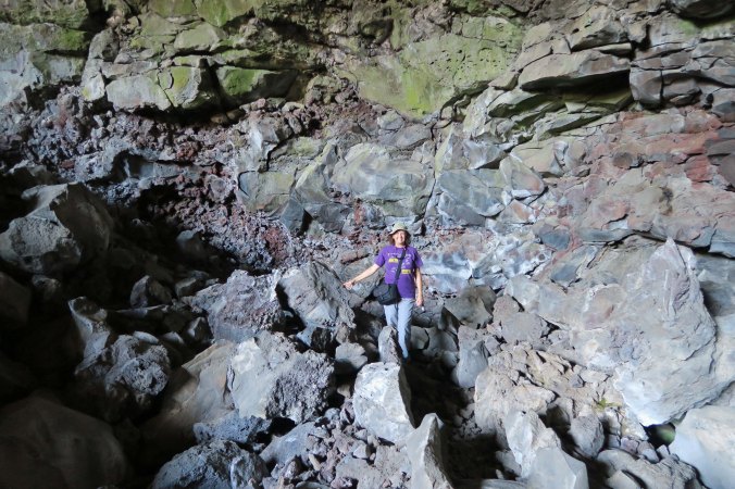
If you live somewhere on the Pacific Rim, you are no stranger to volcanic activity. In this photo, Peggy and I were inside a lava tube looking out at Lava Beds National Monument in northeastern California.
For those of us who call the Pacific Rim home, volcanic activity caused by plate tectonics is a part of our lives, whether we live in Oregon or Japan. Vast oceanic plates plunge under and slip along continental plates, virtually guaranteeing there will be an active or dormant volcano within a few hundred miles of where we live— and that we will feel the earth shake under us on occasion. The Pacific Ring of Fire, as it is known, contains 75% of the world’s active and dormant volcanoes and is responsible for approximately 90% of the world’s earthquakes.
Having spent most of my life in California, Oregon and Alaska, I am no stranger to these facts. I flew over Mt. St. Helens a couple of weeks after it blew its top and was stunned by the destruction. I’ve felt numerous earthquakes. Once, when I was staying in a mountain cabin in the Sierra Nevada Mountains, a minor earthquake struck 30 miles away and it sounded like a freight train was rumbling over our roof. So far, however, I have been fortunate to only witness exploding mountains and earth-shaking quakes at a safe distance. I prefer to keep it that way.
Lately, I confess, I’ve been a bit nervous whenever I make trips to the coast. There has been a lot of discussion recently about the Cascadian Subduction Zone that exists 70-100 miles off the shore; it’s subsiding. The oceanic Juan de Fuca Plate is moving eastward, slipping under the continental North American Plate. The next big earthquake is due, geologists claim, and it will be a doozy, a mother of all earthquakes reaching a magnitude 9 on the Richter Scale. Think of it this way, a level 6 earthquake is capable of doing considerable harm. A level 9 earthquake is one million times stronger.
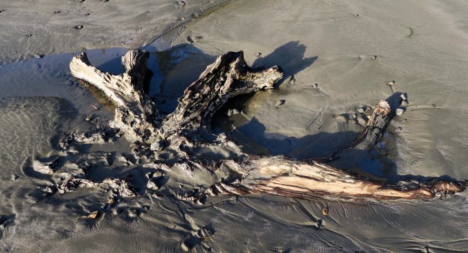
I found this root system of an ancient spruce at Sunset Bay on the Oregon Coast. The roots are all that are left after the last magnitude 9 earthquake sank major portions of the coast and covered the forests with water in 1700.
A huge (100-foot-high) tsunami has been projected. So, I’m always careful to check the tsunami escape routes when I am on the coast. If I am camping in my van and I feel the big shake, I am out of there, heading for higher ground with my power cord and hose dragging along behind. “No time to say hello-goodbye, I’m late, I’m late, I’m late!”
Substantial destruction is anticipated inland as well. We’ve been told that the Applegate Reservoir Dam above us might go. It’s only a mile away. Even though we are a couple of hundred feet above the river, our house is predicted to be right on the edge of where the raging waters would reach. Of course, whatever happens could be 50 years into the future. The science of predicting volcanic eruptions and earthquakes is improving but it is still far from exact.
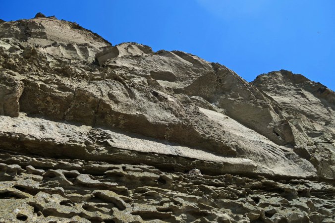
Whether we ever experience the BIG one or not, there are numerous examples of the power of plate tectonic activity in Northern California, Oregon and Washington. Lava Beds National Monument in northern California is one. Minus tsunamis, it’s a great place to explore different types of volcanic activity. Peggy and I stopped off there this summer to check out Native American rock art found in the area.
The lava beds were created by lava moving across the area from the nearby Medicine Lake shield volcano. Shield volcanos are known for their highly liquid lava that prefers flowing to exploding, and Medicine Lake Volcano has flowed a lot in the last 500,000 years— generating some 140 cubic miles of lava covering 770 square miles. Lava Beds National Monument sits on the north slope of the volcano. A number of small cinder cone volcanoes dot the region. These smallest members of the volcano family are built up by blobs of congealed lava blown out of a single vent.
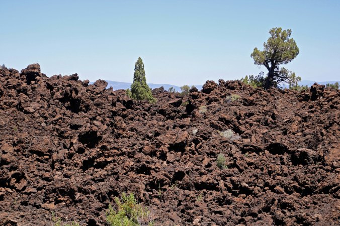
Rugged lava flow at Lava Beds National Monument. (Photo by Peggy Mekemson.)
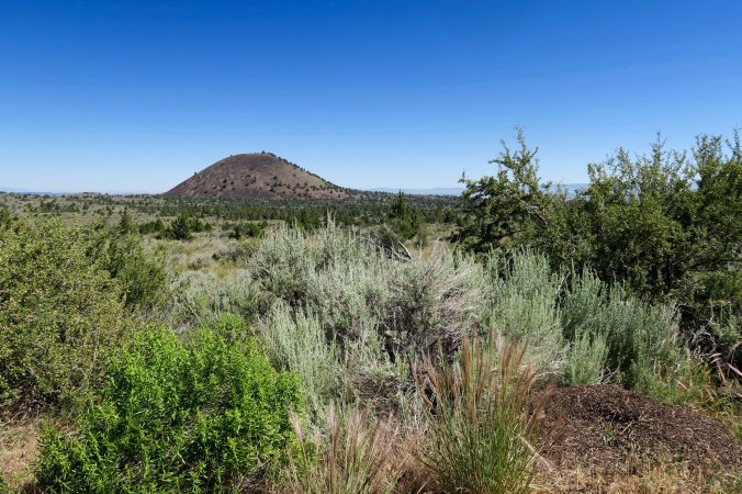
A cinder cone stands out on the horizon at Lava Beds National Monument. The grey plants in the foreground are sagebrush, a common plant of the drier parts of the West.
Mount Shasta towers above the area in the distance. Unlike its neighboring Medicine Lake Volcano, Mt. Shasta is a composite volcano made up of more viscous lava— the type that cools more quickly, likes to erupt, and forms steep sides. It is one of the most beautiful mountains in the Cascade chain of volcanoes that extends from northern California up to Canada. I climbed to its 14,175 peak once with a 76-year-old friend of mine, Orvis Agee. He was known fondly as ‘The Old Man of the Mountain’ since he had climbed it so many times. Climbing was tough; coming down was easier since we slid a thousand or so feet on our butts through the snow, using our ice axes as rudders and brakes.
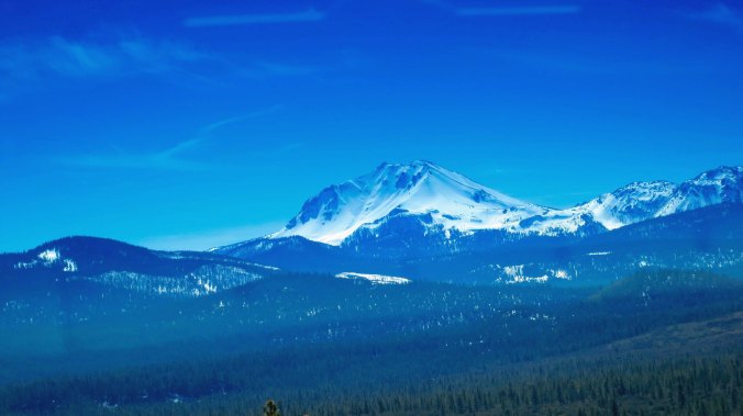
Mt. Shasta seen from the distance.
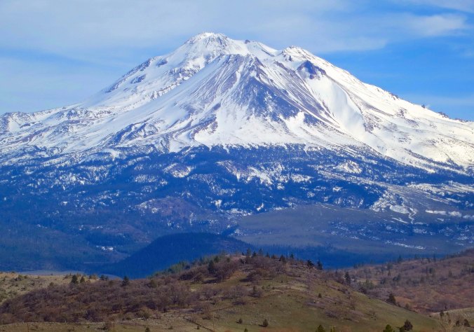
A closer perspective of Mt. Shasta, one of the most striking mountains in the Cascade chain.
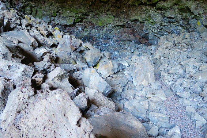
Lava Beds National Monument is particularly noted for its lava tubes. These cave-like structures were created by lava flows in the last 10,000-60,000 years. As the lava cooled and hardened on the top and sides, it continued to flow through tunnels underneath the surface. When the source of the lava ran out, the remaining lava flowed out of the tunnels, leaving the tubes behind, some 700 of them.
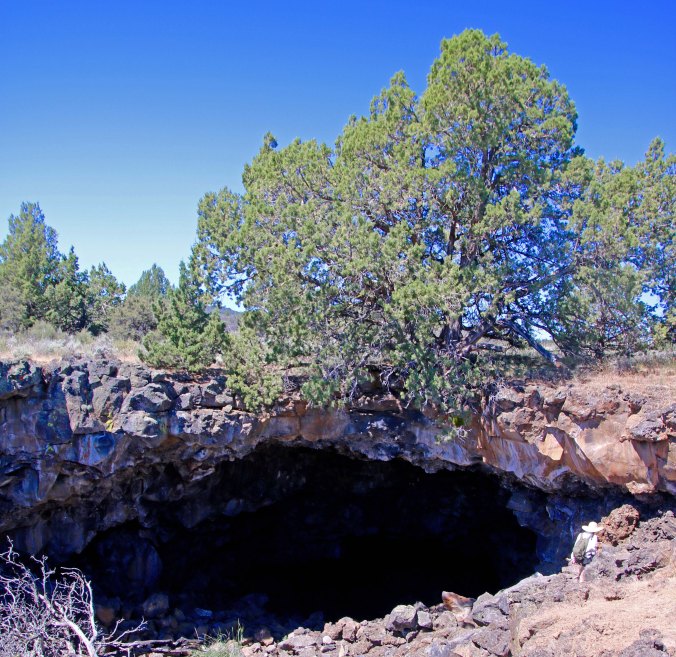
The mouth of a lava tube in Lava Beds National Monument. (Photo by Peggy Mekemson.)

And another. (Photo by Peggy Mekemson.)

This photo taken by Peggy provides perspective on the possible size of the lava tubes.

Numerous collapsed lava tubes are found at the Monument. (Photo by Peggy Mekemson.)
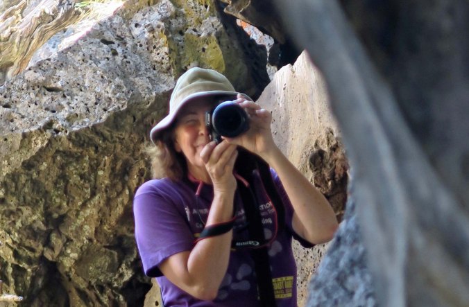
Peggy taking photos at the entrance to one of the lava tubes.
Humans have occupied the area for thousands of years. Paleolithic peoples found the tubes a refuge from the weather and a site for sacred ceremonies. The Modoc Indians used them as a hideout during the Modoc War of 1872-73. The Modocs had considered the area home for generations when white settlers arrived in the area and insisted that the natives be rounded up and shipped off to reservations so they could take over their land. One of the chiefs, Keintpoos, or Captain Jack as he was known by the settlers, found reservation life intolerable and returned to his homeland and hid out among the rugged lava and caves with a small band of warriors. It took a thousand soldiers over six months at considerable expense and loss of life to dislodge the 60 warriors. Captain Jack’s Stronghold is reserved as part of the Monument.

This rugged country including large volcanic rocks enabled Captain Jack to hide out from the American soldiers and fight back for six months.

Hidden entrances to lava tubes like this would have served the Modoc warriors well.

Peggy and I found native swallows nesting near Captain Jack’s stronghold. They attacked us for disturbing their homes.
Settlers and their descendants found other uses for the lava tubes including an ice skating rink and a great place to hide out and make moonshine during the Prohibition Era. Drinking moonshine and ice skating together is not recommended. Lava Beds National Monument was established in 1925.
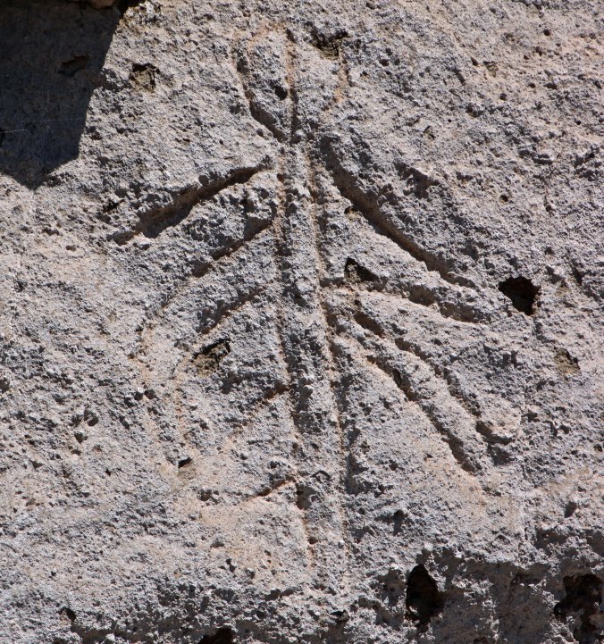
Today, visitors are welcome to explore the lava tubes. Many are spacious and short; others require sliding along on your bellies through tight spaces. Having a bit of claustrophobia, I avoid the latter. Since Peggy and I wanted to check out Native American Rock Art at the Monument on our visit this summer, we headed out to Symbol Bridge and Big Painted Cave, two lava tubes noted for the pictoglyphs. First we had to be screened for white-nose syndrome, however, which sounds like a rather nasty disease of people with white noses, but is actually a serious fungal disease that has been rapidly wiping out bat populations in North America and around the world. Since the lava tubes house a substantial population of bats, the park staff wanted to know if we were wearing “boots or other gear used in caves or mines outside of Lava Beds since 2006, or in caves or mines outside of the United States ever.” We hadn’t and were given a little sticker saying we passed inspection. Following are some of the pictoglyphs we found.

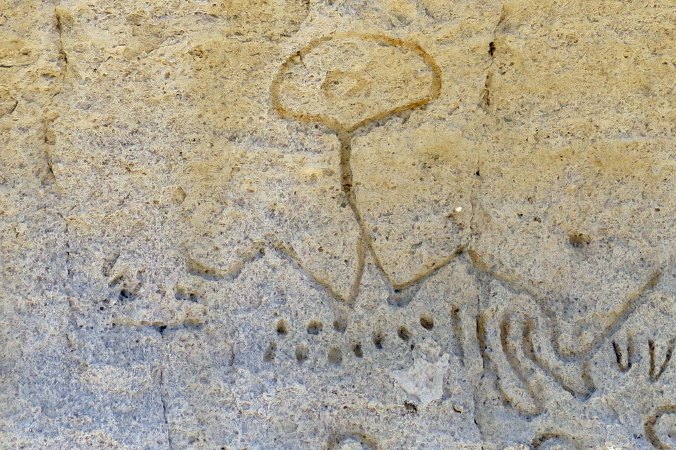
This rock contained numerous pictoglyphs that are actually painted on the rocks. While we don’t know for sure what the rock art represents, I would guess a person, plant life, storms and vaginas.
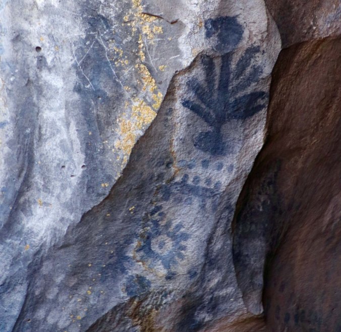
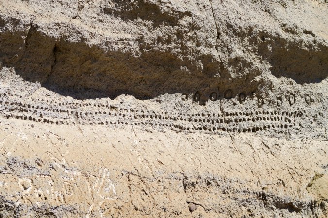
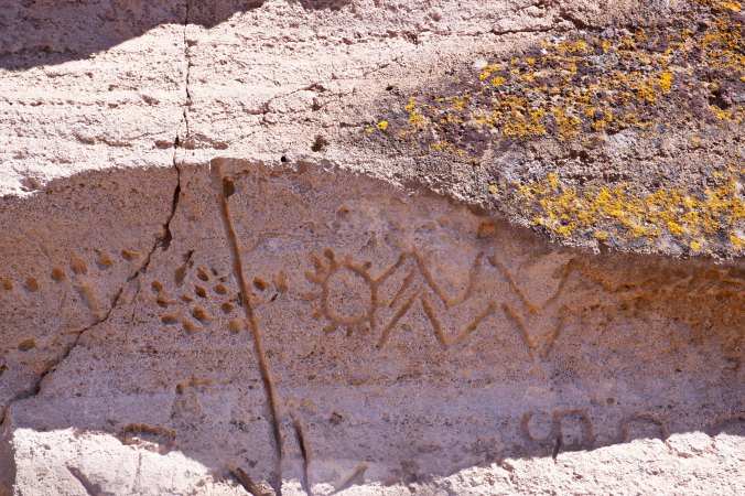
A plant, the sun and possibly some type of counting system to keep track of time. (Photo by Peggy Mekemson.)

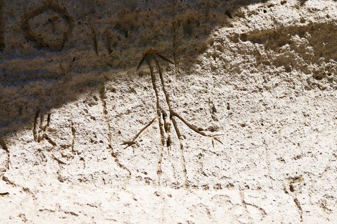
My last example for the day. More suns? An animal and who knows? This rock art appears to have been finger painted on to the rocks. (Photo by Peggy Mekemson.)
NEXT POST: While the rock art at the entrance to the lava tubes seemed limited, this wasn’t the case at nearby Petroglyph Point where over 5000 images were carved into the rock on what was once an island in Tule Lake. My next post will feature the rock art from this location that was obviously a very sacred place to the Modoc and earlier native people, possibly going back 5,000 years.
SaveSave
SaveSave
SaveSave