In our last post we emphasized the beauty of El Morro and checked out the waterhole that has drawn people to El Morro for the past thousand years. Our focus was on the Spaniards and the pioneers who left their signatures behind. Today we are going to spotlight the Ancestral Puebloans who lived on top of the monument in the 1200s and left petroglyphs on the cliff near the waterhole.
Peggy and I were admiring the petroglyphs and signatures on the walls of El Morro when a woman walked by and gushed, “Aren’t the signatures wonderful.” And then, dismissively, “You can find petroglyphs anywhere.” We didn’t disagree on the signatures. The first one had been carved into the rock by the Spaniard Don Juan de Oñate, 15 years before the Pilgrims landed at Plymouth Rock. But the petroglyphs reflect the life of a people who were living here hundreds of years before Oñate was born.
While our understanding of the petroglyphs is limited, we can appreciate the creativity and at least guess at their meanings. The four big horned sheep walking in a row on the Inscription Loop Trail are still four big horned sheep walking in a row, regardless of what else the petroglyph might mean. With insights from the beliefs, legends, and interpretations of modern pueblo people and other indigenous groups, our guessing can improve, opening a whole new world of wonder for us. They certainly have for Peggy and me.
The pueblo, signatures, and petroglyphs are part of the rich history that our public lands preserve and protect. It’s an important aspect of what our national parks and monuments do. Without this protection in El Morro, graffiti would likely cover the inscriptions and petroglyphs on the Inscription Loop Trail, while much of the Atsinna Pueblo would be dug up with zero concern for history— left in shambles as treasure hunters search for ancient artifacts to sell. Before the creation of our park system, such pillage was common. It still can be in unprotected areas.
Today we are facing an even more insidious threat: erasing our history. Apparently, the Trump Administration has decided that including what we have done wrong in history detracts from America’s greatness rather than serving to remind us that we can do better. For example, my Great Grandfather in Illinois utilized his house as a part of the Underground Railroad. It was dangerous. He was helping free slaves. In early April, a page on a national park website described the effort this way: “The Underground Railroad — the resistance to enslavement through escape and flight through the end of the Civil War — refers to the efforts of enslaved African Americans to gain their freedom by escaping bondage,” the page began. The statement was removed as well as a photo of Harriet Tubman, who was central to the effort. The Underground Railroad became part of the Civil Rights movement. There was to be no mention of slavery. After a sustained outcry and substantial media attention, slavery and Harriet Tubman were returned to being part of our history.
It continues. Two weeks ago, Interior Secretary Doug Burgum issued Secretarial Order 3431 that instructs all land management agencies, including the National Park Service, to post signs asking visitors to report any negative stories about past or living Americans by rangers or in signage— even if it is historically accurate.
Rewriting history to match the President’s concept of it and asking Americans to spy on Americans is a whole new type of scary.
And now, it’s time to return to our post on El Morro National Monument, which is part of our series emphasizing the beauty and value of our national parks, monuments, historical sites and other public lands.
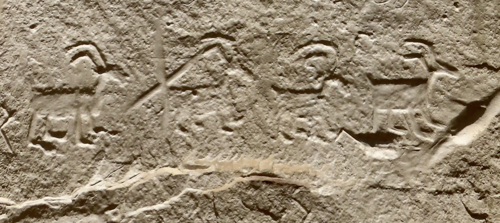
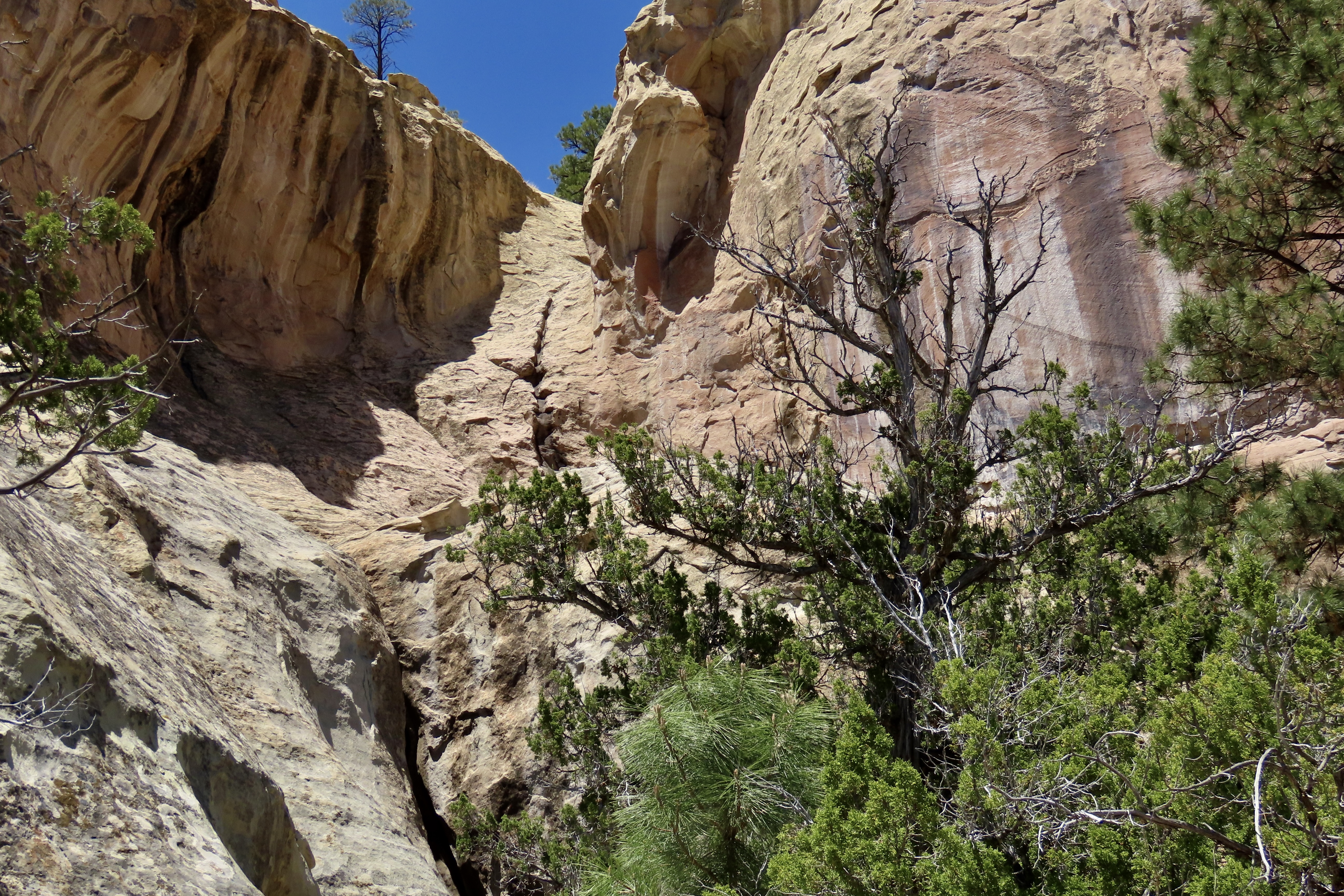
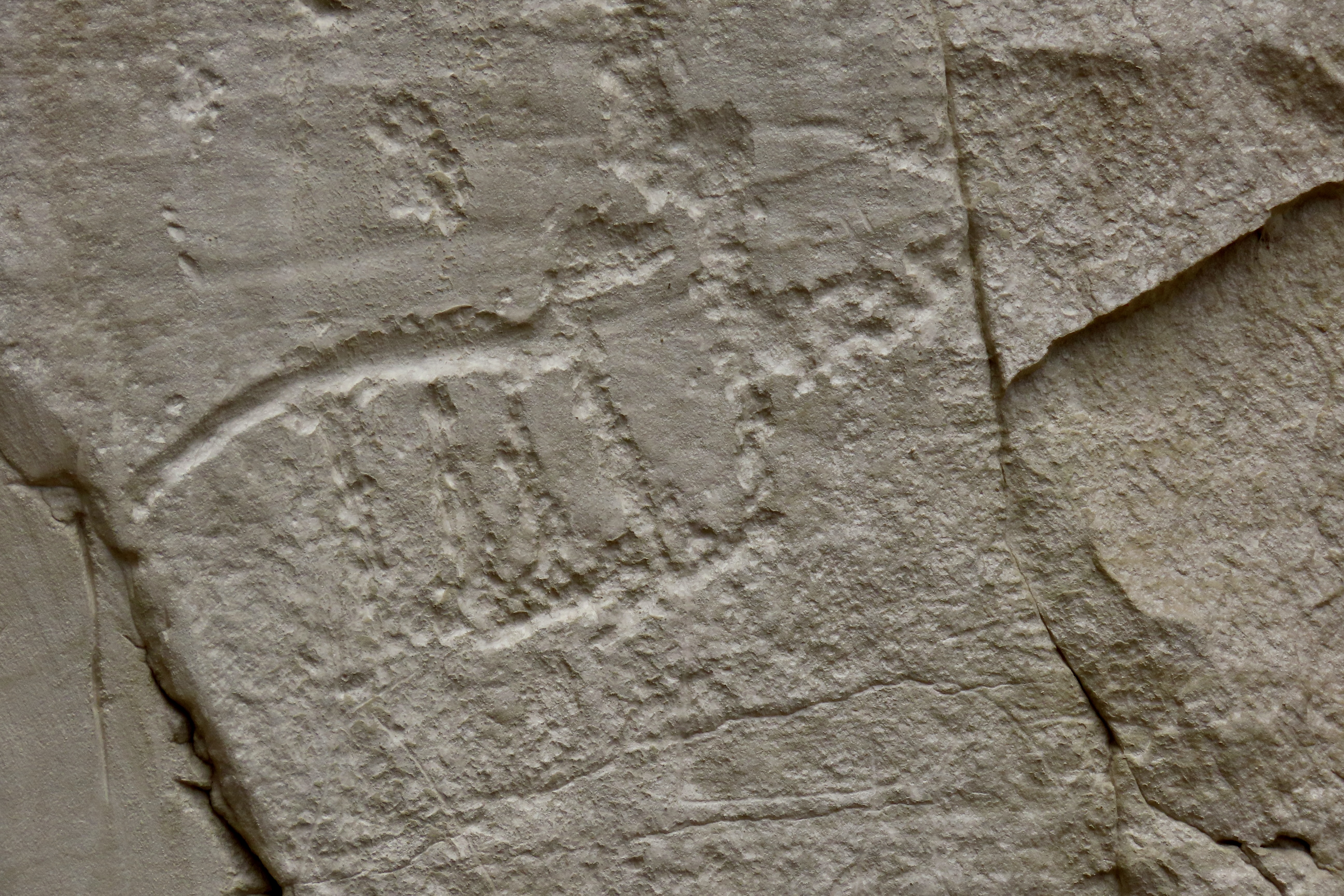
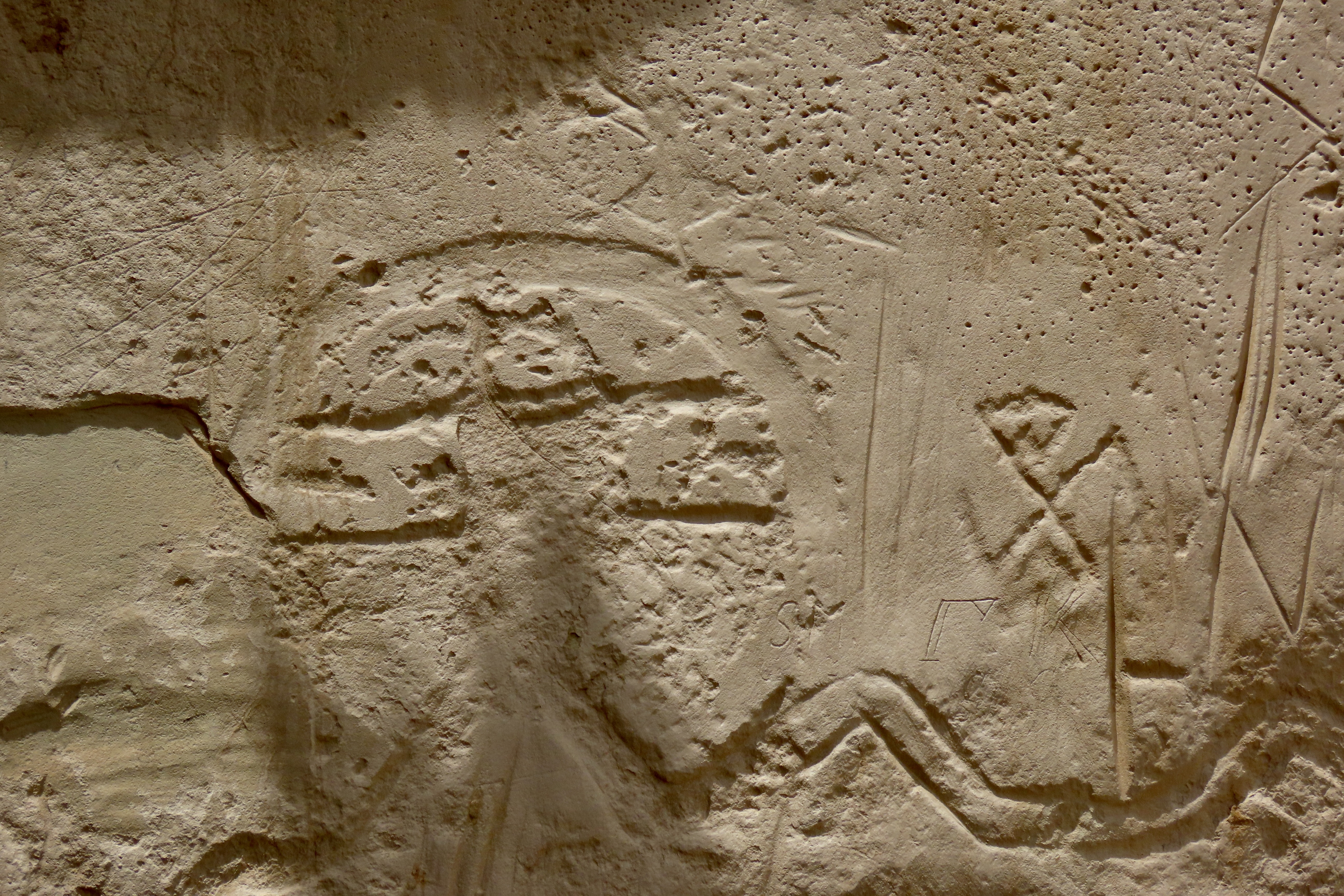
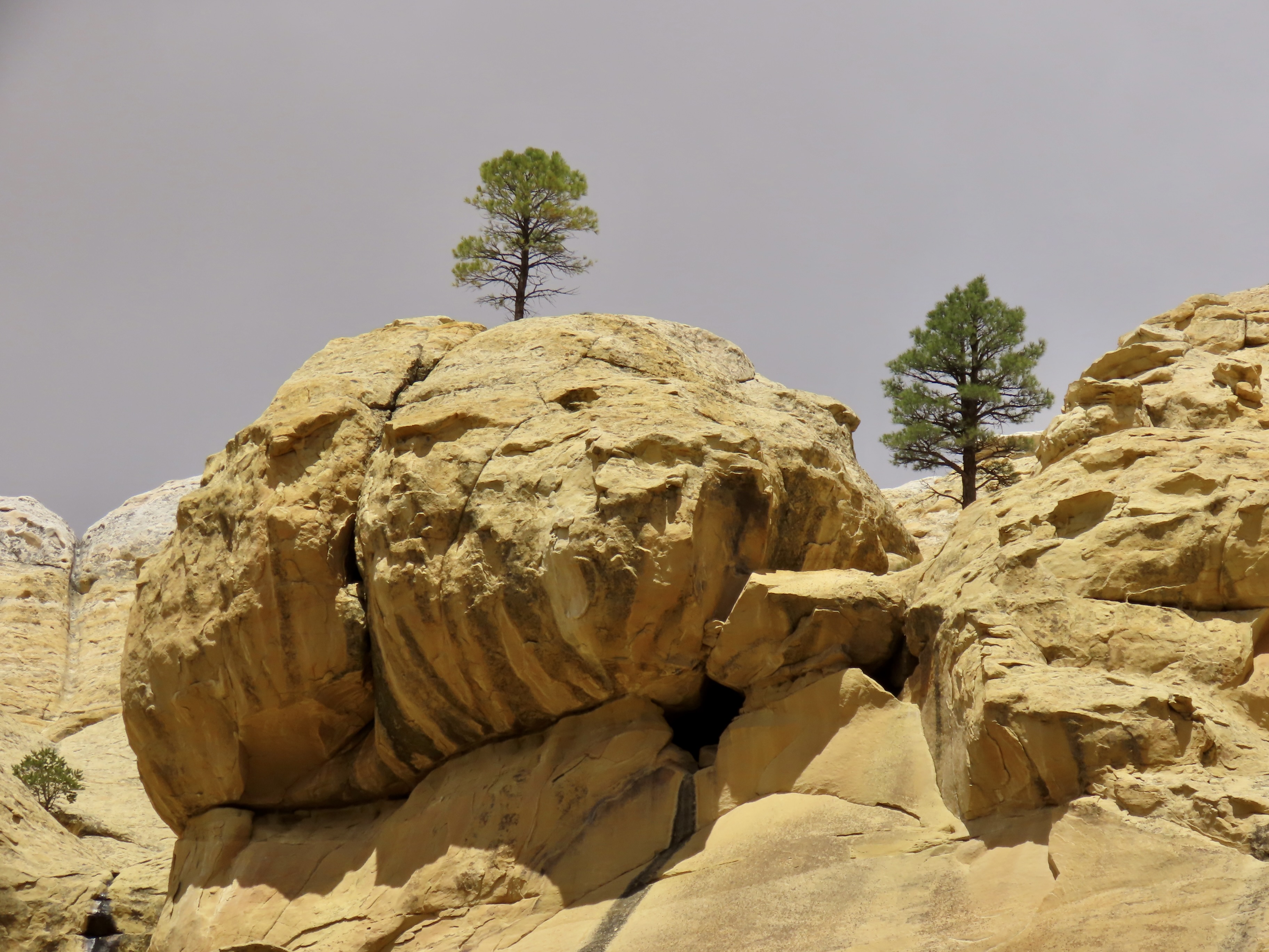
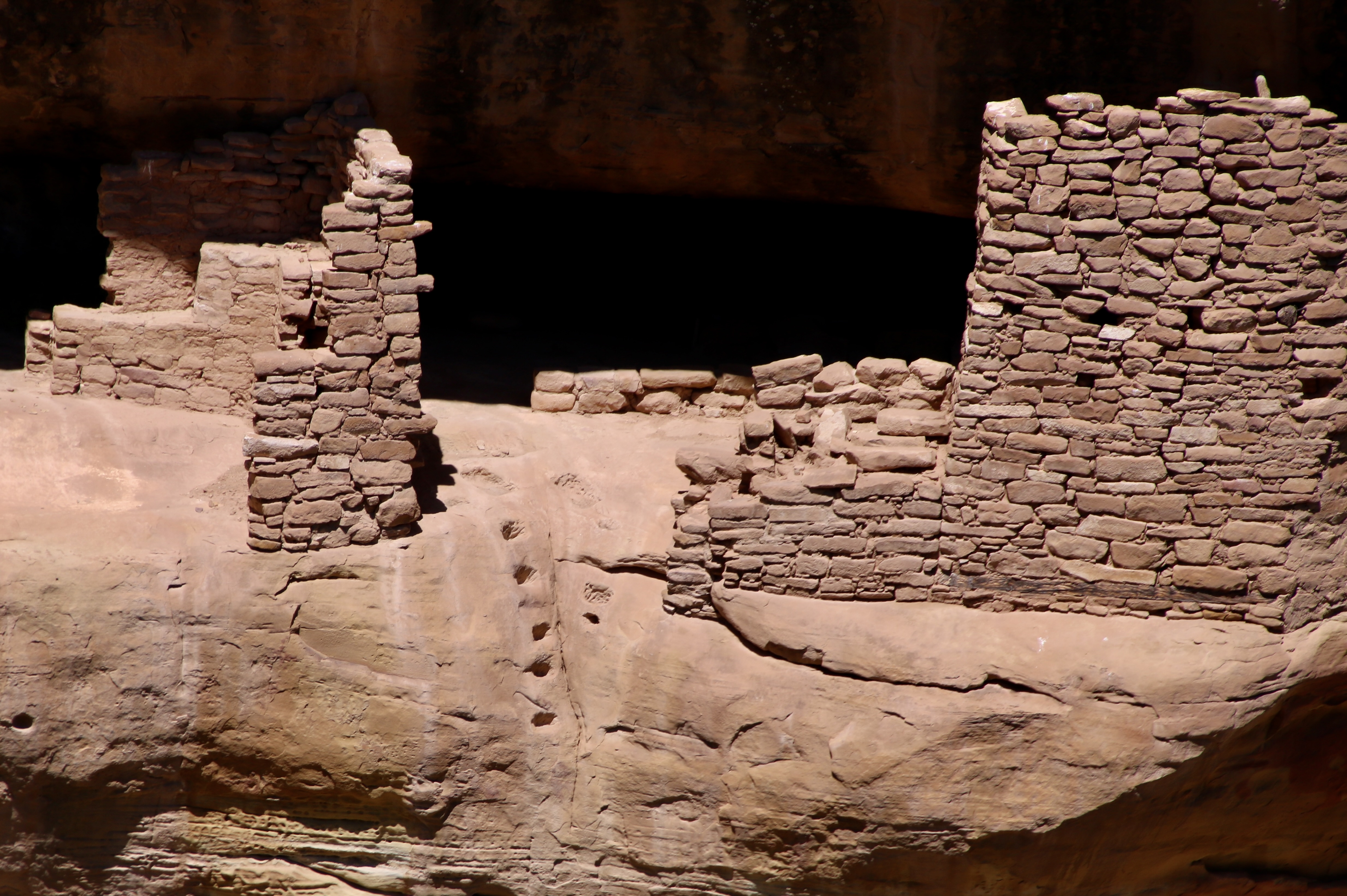
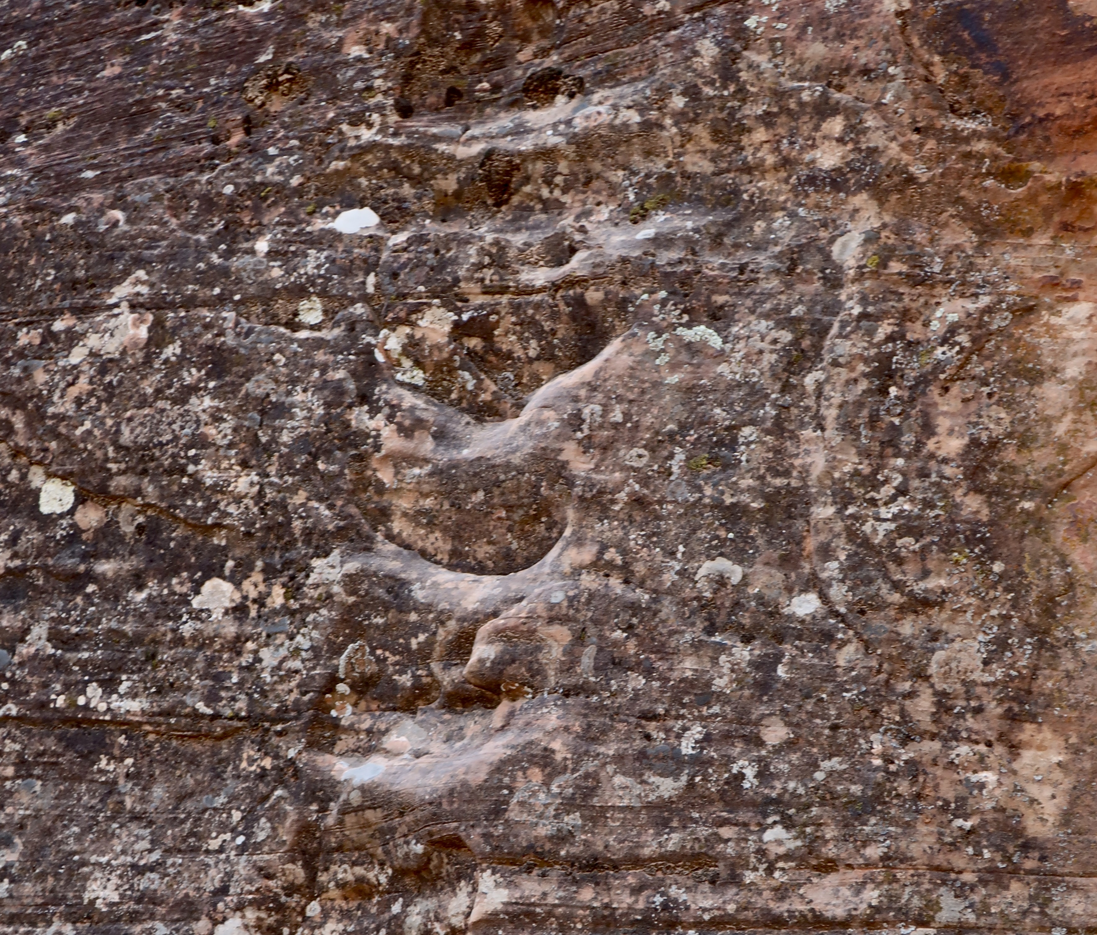
We found these holes in the rock near the waterhole. We’ve seen similar holes at a number of other pueblos. They are foot and hand holds that the Ancestral Puebloans used to reach their cliff dwellings, and, in this instance, Atsinna, the pueblo up on top of El Morro.The water hole is off to the right. The foot holes are behind the pinyon trees center left. It’s thought that the Ancestral Puebloans worked their way up the draw to the head of the canyon where they would have used a ladder or rope to climb up to the top. Note the door like structure on the left. Peggy was fascinated with it. The rangers told us it was caused by how the minerals in the sandstone split. The major splits, like those to the right and left of the ‘door,’ cut through the whole bluff and help determine where major erosion takes place.A close up of the canyon gives a better perspective on the nature of the climb. Imagine carrying water up! Not easy. My imagination (plus experience from 50 years of backpacking) would have them work across the canyon to the dark split, follow it up, work around the boulder and then use a ladder or rope on the last section. I was amused to learn that one type of ladder that Ancestral Puebloans reportedly used was cutting foot notches in a slender log…Like this one I used as a Peace Corps Volunteer in Africa (1966). Grin.El Morro National Monument protects the petroglyphs found in the park. Some of these would have been carved by the residents of the Atsinna, while others would have been left by Ancestral Puebloans living in different locations in El Morro Valley. Add to this, petroglyphs left behind by indigenous peoples living in the area before the Ancestral Puebloans, and it’s likely that the petroglyphs represent several cultures. We found 25 on this panel alone including several hands, a likely bear print, lizards, a snake, a deer and possible sandal prints. Some of the petroglyphs may represent various clan symbols. I would guess the holes were made by people using the petroglyphs for target practice.There are times when Peggy and I just have to smile at a petroglyph whether the original artist meant us to or not. This long legged coyote or dog is a case in point. Road Runner, of cartoon fame, might have been in serious trouble had Coyote had legs like this.While this may not be the case here, this petroglyph is often used to represent a woman having a baby. It isn’t surprising that such an important event is commonly found among petroglyphs.We rarely find petroglyphs in the Southwest that don’t include lizards (and snakes). No surprise.This particular series of petroglyphs contained three important symbols of Ancestral Puebloan culture. The large round petroglyph with its two lines represents the Sun Father, one of the most important deities of Zuni Culture. The squiggly line is the water serpent that helped Ancestral Puebloans find water, a critical contribution to their survival in Southwest deserts. The swastika-like symbol on the right was used in Europe, Asia and America long before it was adopted by Hitler. In the Southwest, it was used by both the Navajos and the Ancestral Puebloans with a positive message. The Zuni saw it as a whirling log that represented the six cardinal directions: North, South, East, West, Up and Down— and the guardians associated with each direction.
I joked with the park rangers when we came back to see Atsinna about using the Ancestral Puebloan route up. He laughed, “I’d recommend the stairs. There are 130 of them.” “Piece of cake,” had been my response. “Actually,” he amended, “there are 132.” “Oh no!” I whined.
Some of the steps leading up to Atsinna. I suspect that the Ancestral Puebloans would have loved them.We stopped frequently on our way up to Atsinna to admire the view over El Morro Valley.And admire the wildlife. Not our best lizard picture, but she’s special. The desert whiptail lizard reproduces by parthenogenesis, which is a rather long word that means she doesn’t need a male in her life to make babies. (Although she can do it the old fashioned way.)Eventually, we reached our goal. The climb up had been easy, given our stops to admire the scenery. The name Atsinna, which means ‘place of writing on the rock,’ was given to the pueblo by the Zuni whose home pueblo is a short 34 miles away.
One of the real treats on our visit to El Morro was to meet two Monument Rangers who are Zuni and live at the Zuni Pueblo: Calvin and Valentino. We first met them when we were hiking up to Atsinna and they were doing trail work, and again when we came back down, this time just outside of the Visitor Center, where we talked for a half hour or so. Before we could ask, Valentino explained to us he was named Valentino because he was born on Valentine’s Day. I’m sure he gets asked that question a lot. I had been picturing the dashing “Latin Lover” of the silent film days, Rudolph Valentino.
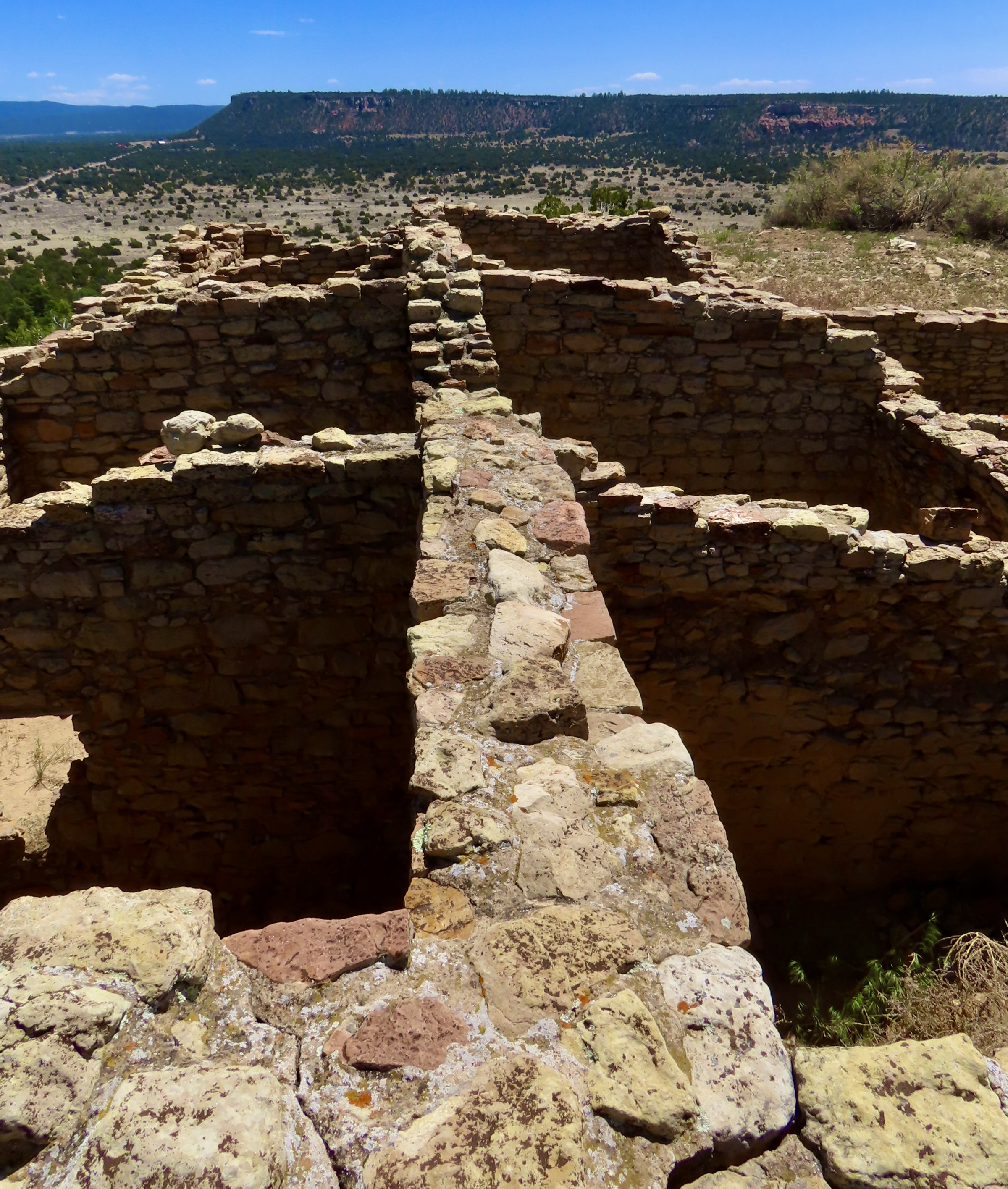
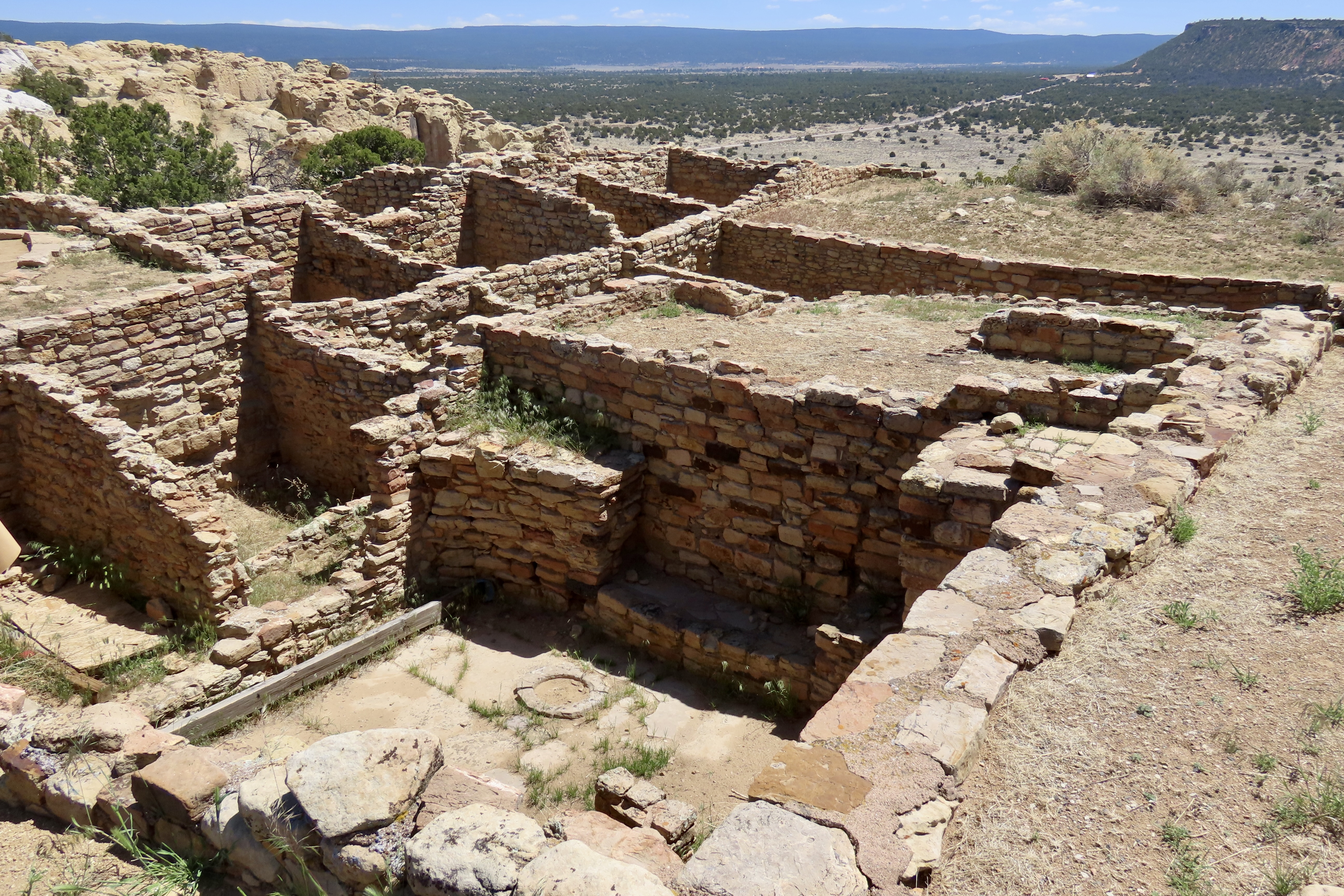
In addition to working at the Monument, both held important roles of educating children at the Zuni Pueblo on tribal history, culture and language. At 70, Valentino was a tribal elder. Our discussion ranged from the preservation and restoration of Atsinna Pueblo to the Zuni Belief system.Atsina was built around 1275 CE and occupied for a hundred years or so. It covers an area of 200’ by 300’ and accommodated between 500-600 people. There were 355 interconnected rooms that surrounded an open courtyard.This old aerial shot by the National Park Service shows the original size of the Pueblo outlined by the difference in vegetation as well as the rooms that were excavated in the 50s.Another view of the excavation. The room in the front is one of two kivas excavated at Atsinna, this square one and a larger round one.Kivas were central to Puebloan life for important religious rituals and ceremonies. They also played a role in maintaining social cohesion and supporting cultural traditions. Most were laid out in a similar fashion. Pueblo people today continue to build kivas and use them much in the same way.Preservation and restoration has become an important part of maintaining Atsinna and other Pueblos. Valentino and Calvin told us that the excavation of the 1950s had used concrete to reinforce the upper walls. The added weight had caused the walls to collapse. Walls are held together today using materials that mimic the original in texture and hardness. A view of the top as seen from the pueblo. I found the contrasting colors of the red and white sandstone both interesting and photogenic. Atsinna rests on the red Dakota sandstone deposited in a Mid-Cretaceous Sea. In turn, the Dakota sandstone rests on bleached Zuni sandstone that was laid down around 150 million years ago when a vast Saharan type desert of sand covered the area. What’s known as an unconformity of 80 million years exists between the Zuni and Dakota sandstone, i.e. 80 million years of geological history was eroded between the two! That’s enough for today! More than enough?
Next up I am going to explore three wilderness areas in California as part of my series: The Mokelumne, Granite Chief/Desolation, and Marble Mountains Wilderness areas. While these wilderness areas are not presently threatened by Trump Administration policies, there is no guarantee that they won’t be.
El Morro National Monument is located in western New Mexico about 40 miles south of the Route-66 town of Grants (just off I-40) in a water starved region. It’s hardly surprising that a year round waterhole located at the base of the promontory has been a welcome stop for people passing through and/or living in the area for over a thousand years. Many left their mark.
Ancestral Puebloans— whose descendants include modern day Zuni— came first. They lived on the top of El Morro in a pueblo that the Zuni have named Atsinna, and climbed down to the waterhole where they gathered water and used rocks to pound and carve petroglyphs into the relatively soft Zuni sandstone.
The Puebloans were followed by Spanish treasure hunters driven by an insatiable hunger for fabulous wealth and everlasting glory. They believed they would find it in the legendary, gold-filled Seven Cities of Cibola. (El Morro is in modern day Cibola County.)The treasure hunters were accompanied by Spanish missionaries with a different goal: Winning souls for God and King. Turns out the the cities of gold were a myth and the indigenous population didn’t understand why they couldn’t keep their own deities while accepting God’s help as well. They were even more dubious about a distant king whose motives were questionable at best.
Finally, American pioneers and soldiers passed through in the mid-1800s. The pioneers were seeking a new life from the one they had left behind in the East. They, too, were searching for treasure but theirs was to be found as farmers, ranchers, miners, loggers and merchants. The fact that indigenous populations already lived in the areas they wanted to settle was of little concern, unless, of course, the natives objected. That’s what soldiers were for.
The Spaniards and Americans, like the Puebloans, left their marks on the cliff, but this time they signed with their signatures using chisels and knives. One of the primary reasons people visit El Morro is because of the various signatures and petroglyphs. There are over two thousand. Some, like Peggy and me, also come because of the beauty and culture.
Because of the length of this post, I’ve decided to break it into Part 1 and Part 2. The first part will emphasize the area’s beauty and the early visits by Spaniard treasure hunters and American pioneers between the 15th and 18th centuries. In the second part, Peggy and I will focus on the Ancestral Puebloans from the 11th century.
Today, Peggy and I are continuing our series on national parks, monuments, and wilderness areas with an emphasis on their unique beauty, geology, flora, fauna and history that makes them so important to us today— and to our children, grandchildren and future generations. I can only repeat how vital it is at this point in history to let decision makers know how we feel about protecting and maintaining public lands. It makes a difference.
For example, the Trump Administration’s provisions for selling off public lands and building a mining road through the Gates of Arctic National Park in Alaska were both removed by Republicans from his “Big, Beautiful, Bill” last week for FY 25/26. Once gone, the public lands (that belong to all of us) would be gone forever. As for Gates of the Arctic, it is one of the world’s largest remaining roadless and trail-less wilderness areas. A road through the heart of it would change its pristine nature significantly and open up other National Parks for similar treatment.
As with each of our previous posts in this series, we will present photos that focus on the beauty and unique characteristics of the park, monument, or wilderness we are blogging about. All photos have been taken by either Peggy or me unless otherwise noted.
Now, please join us as we explore El Morro.
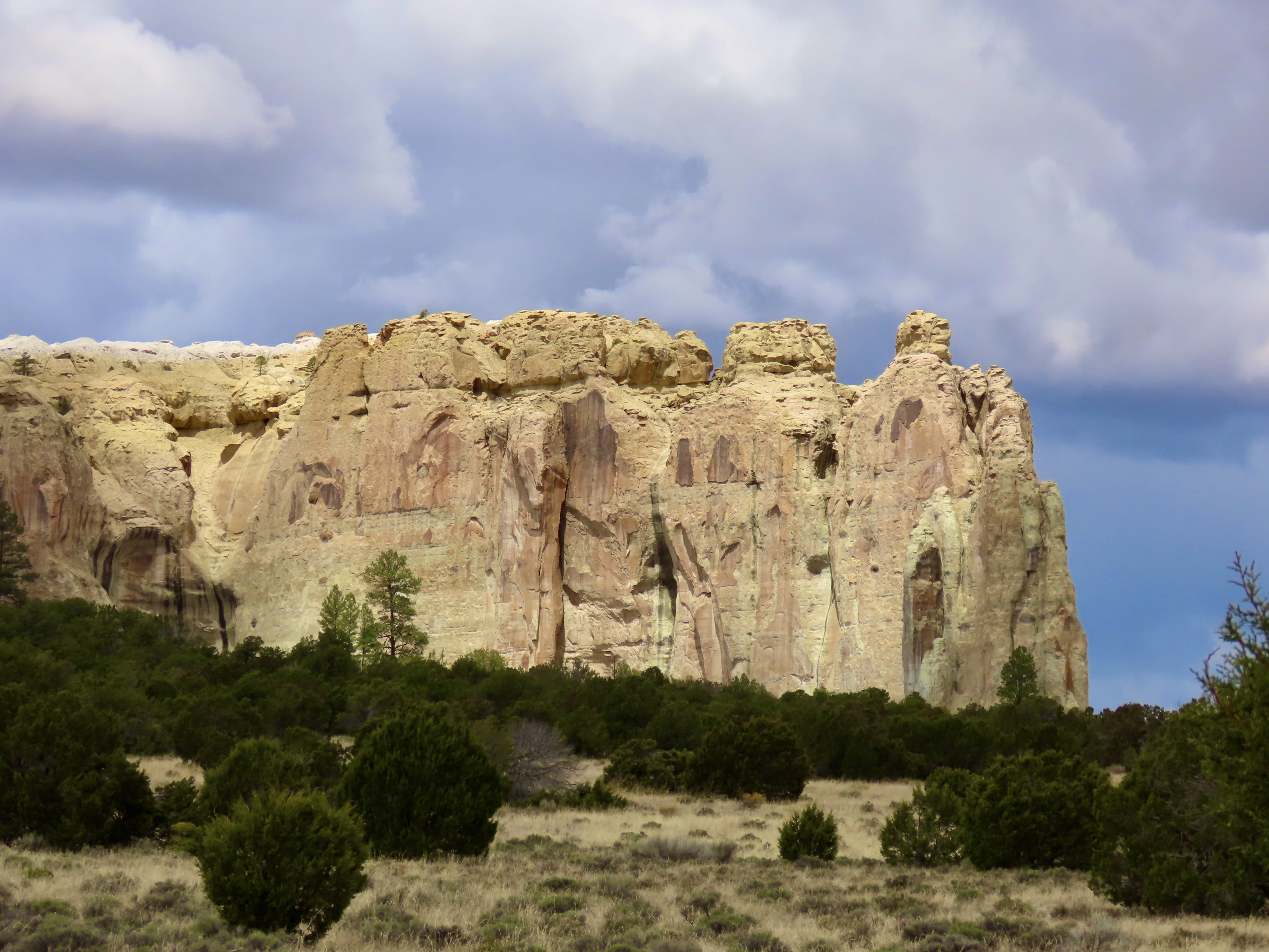
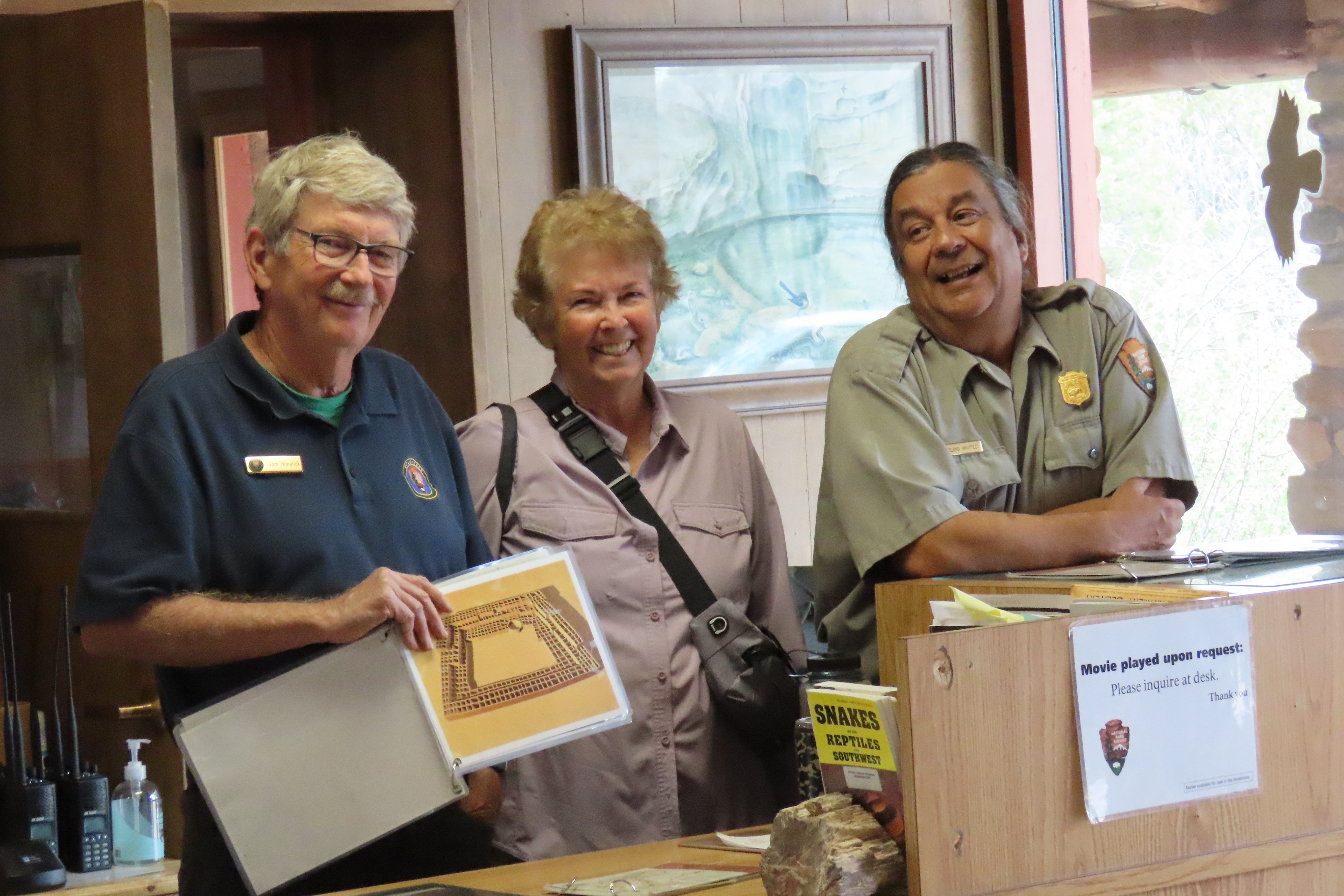
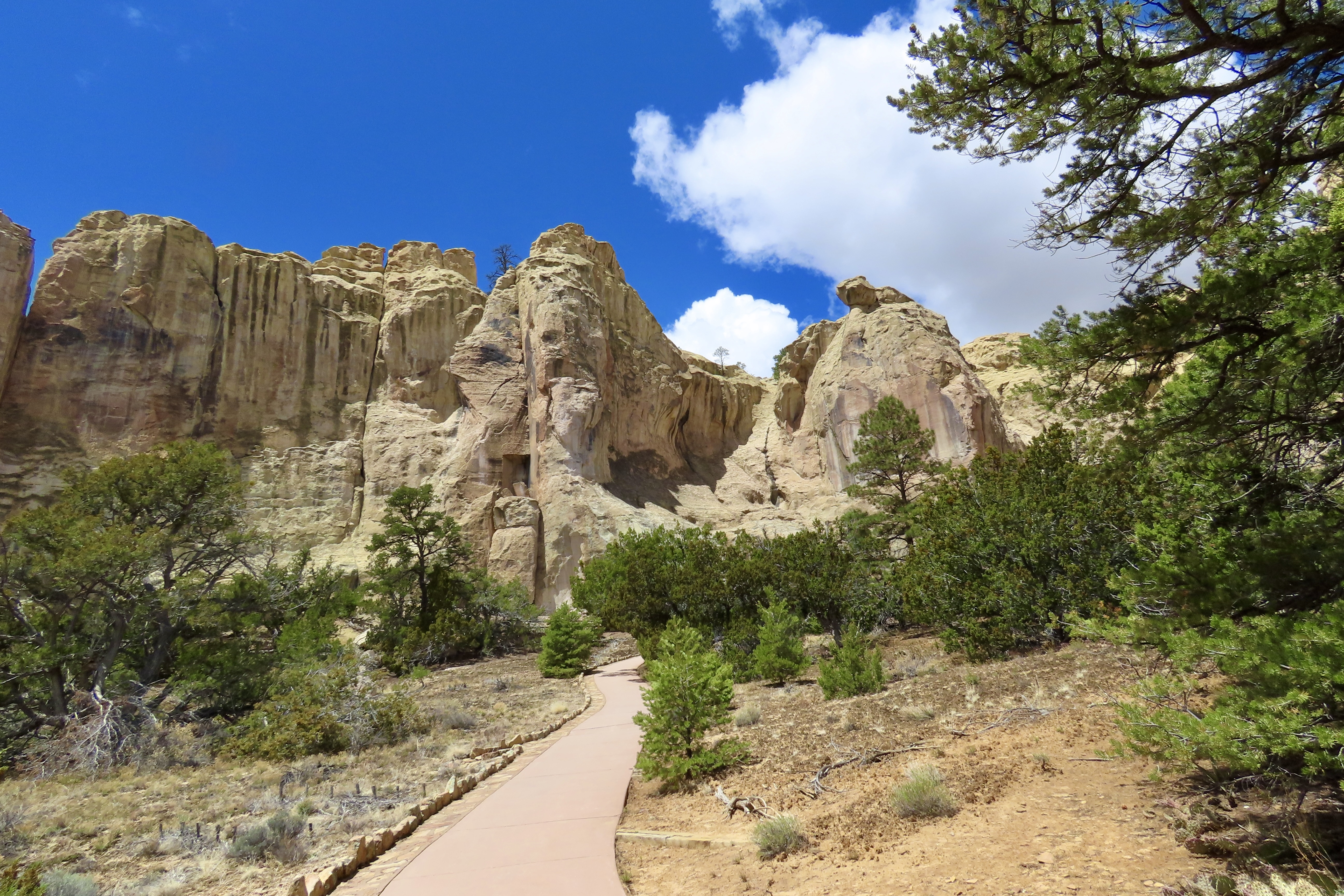
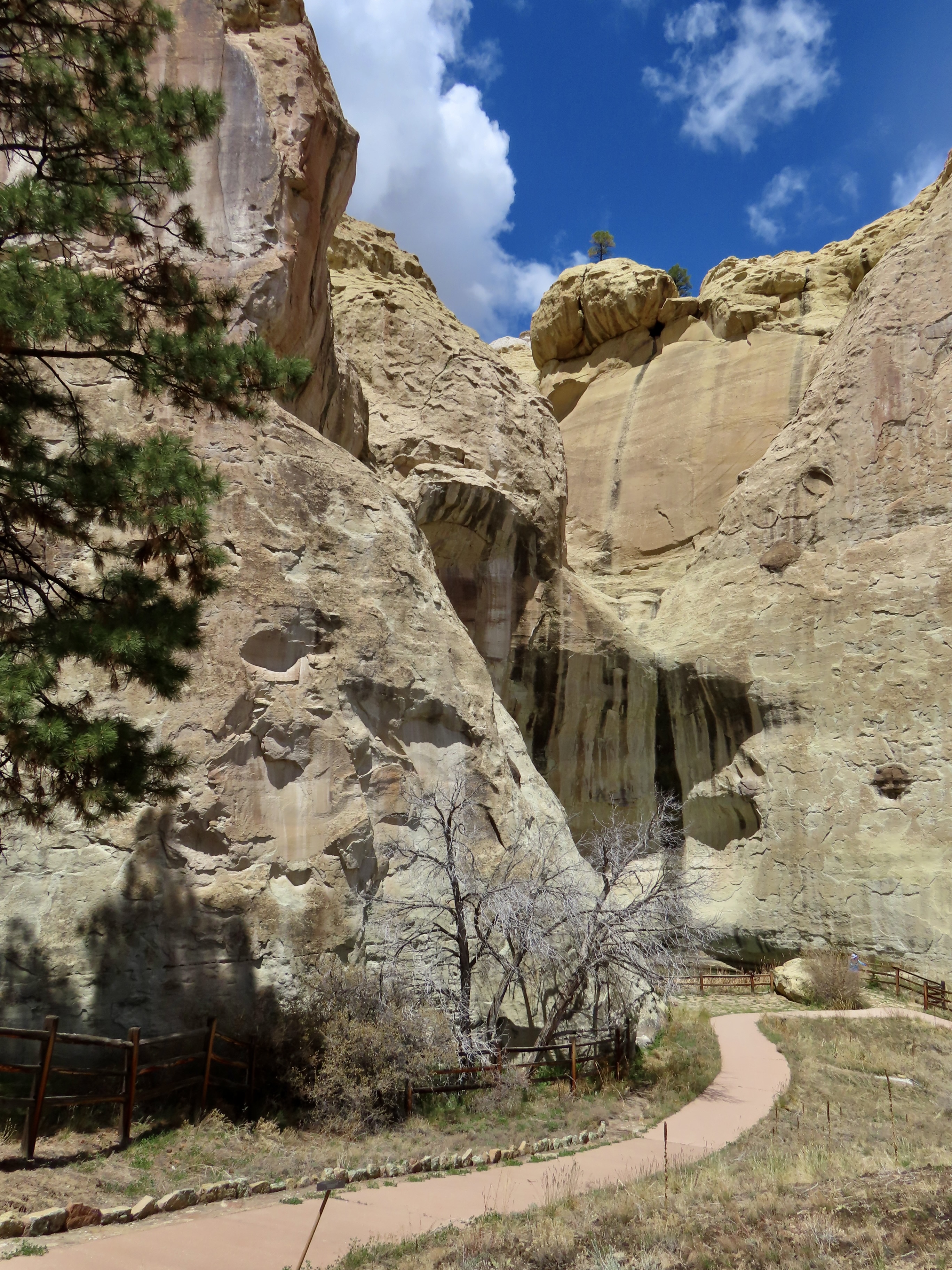
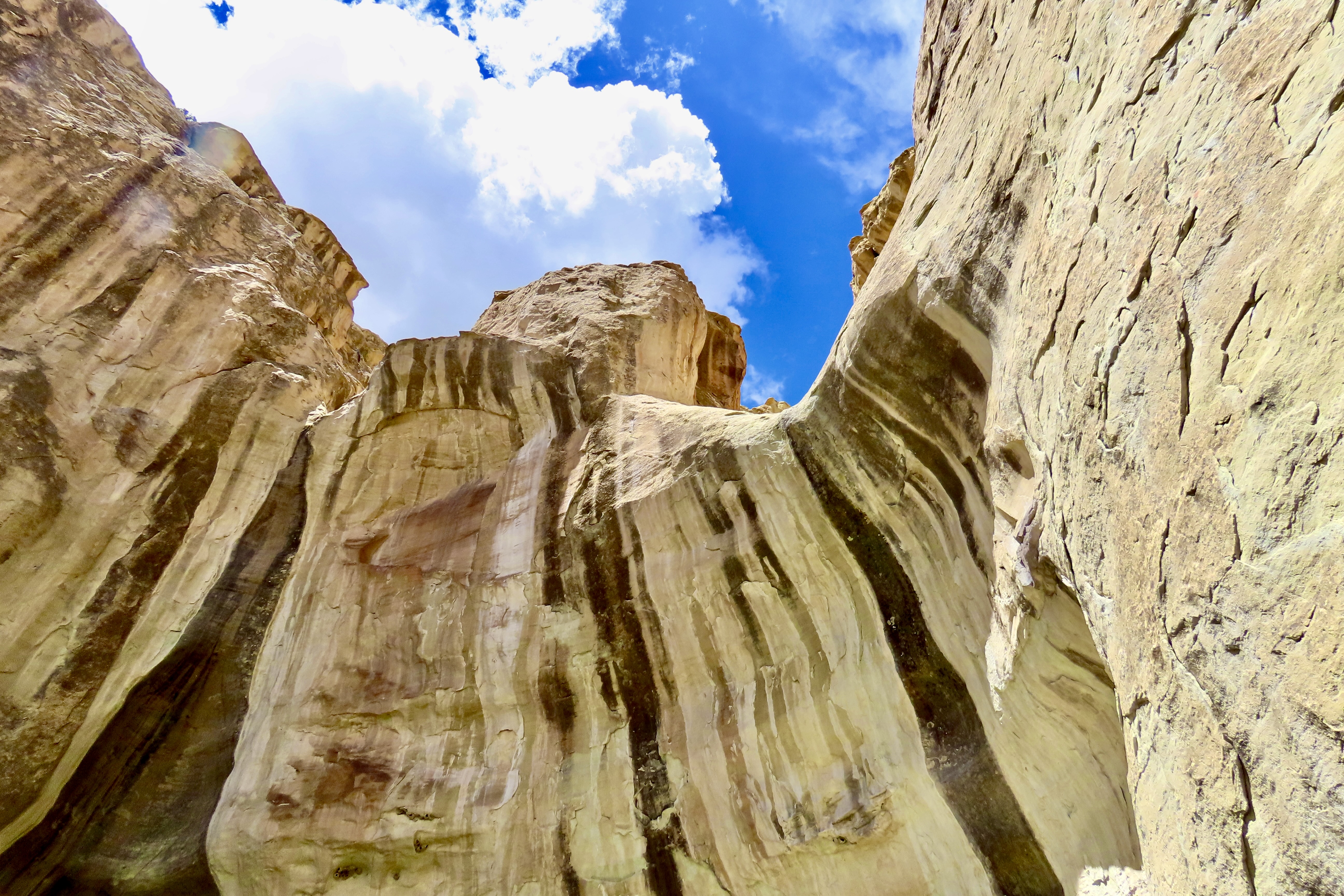
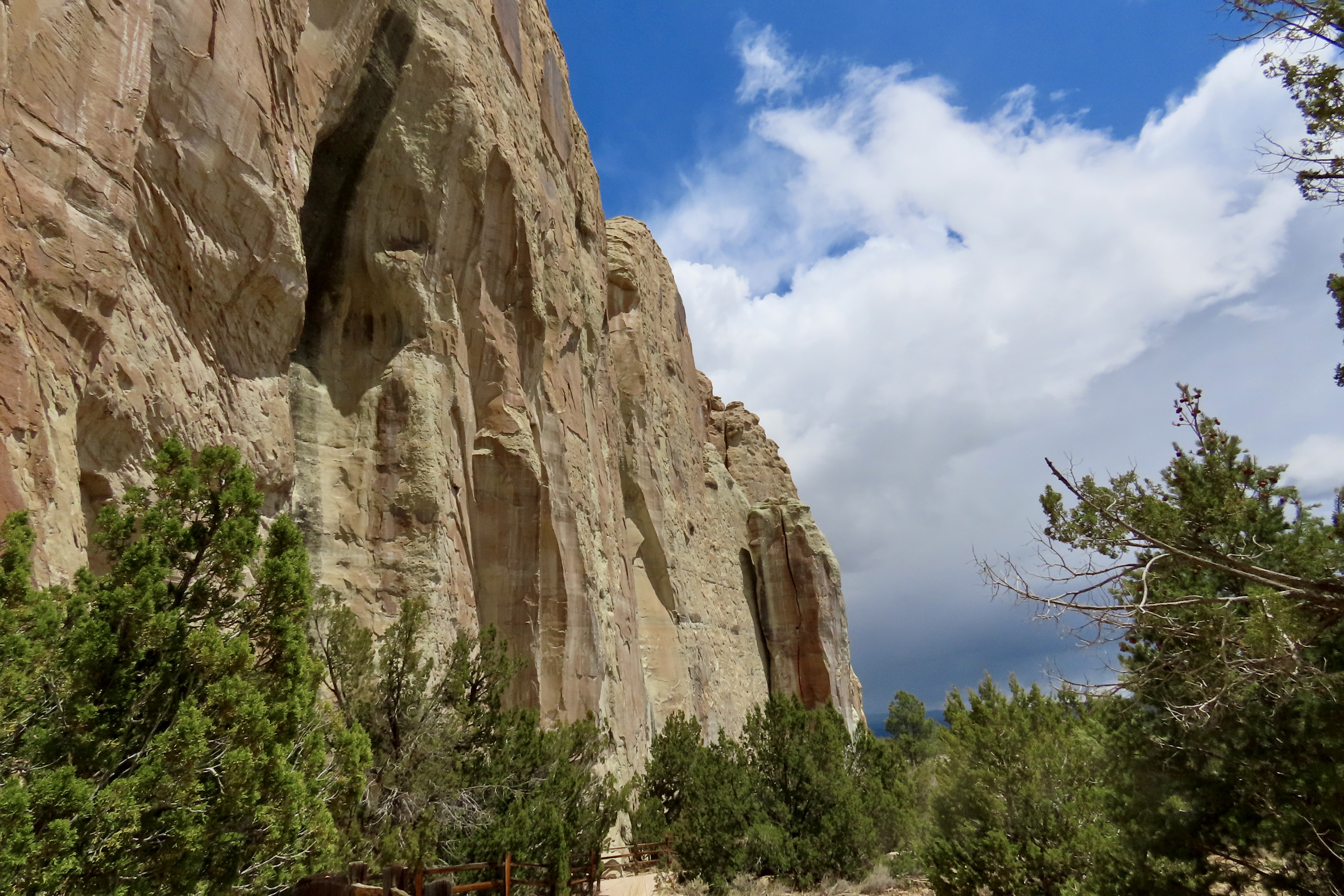
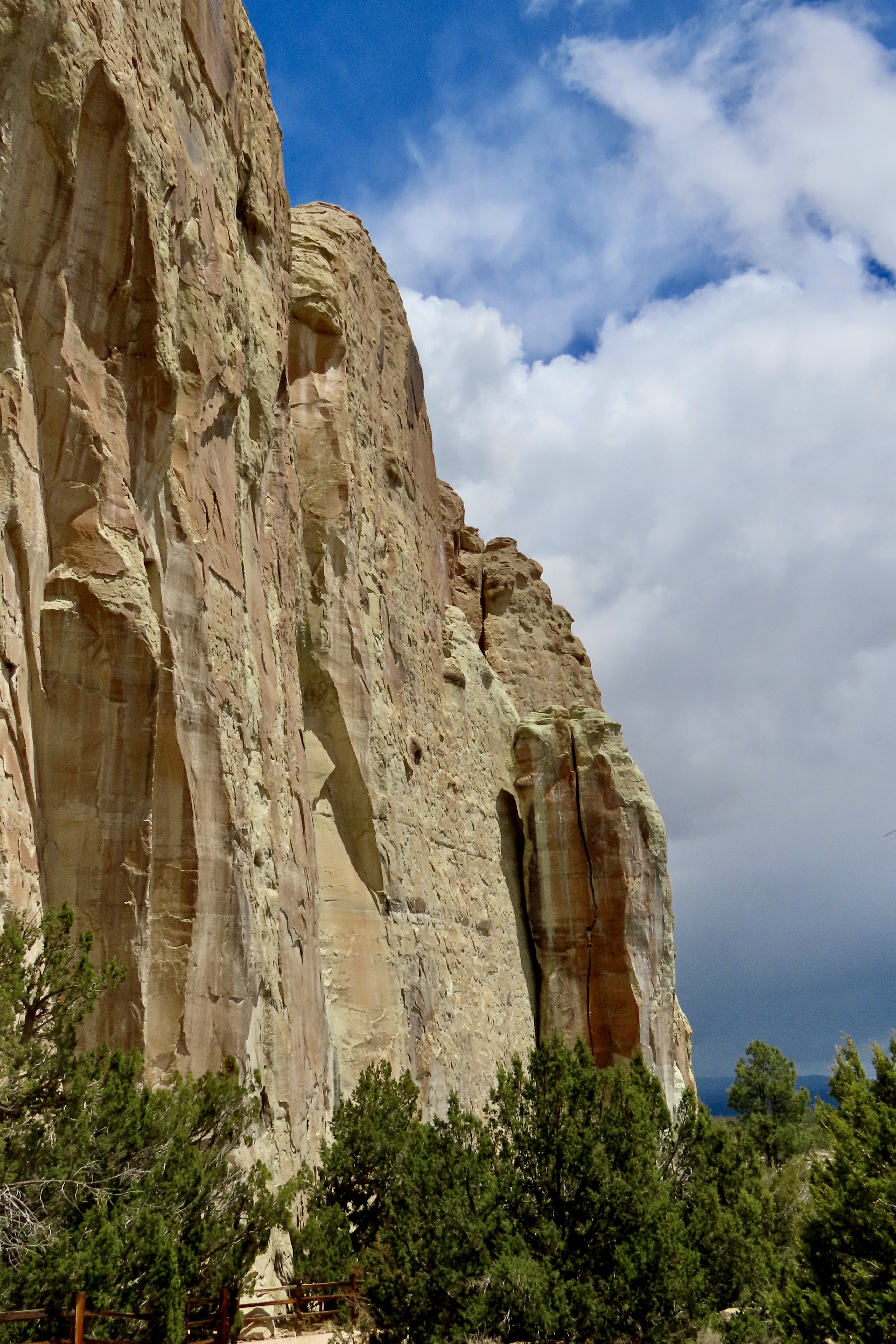
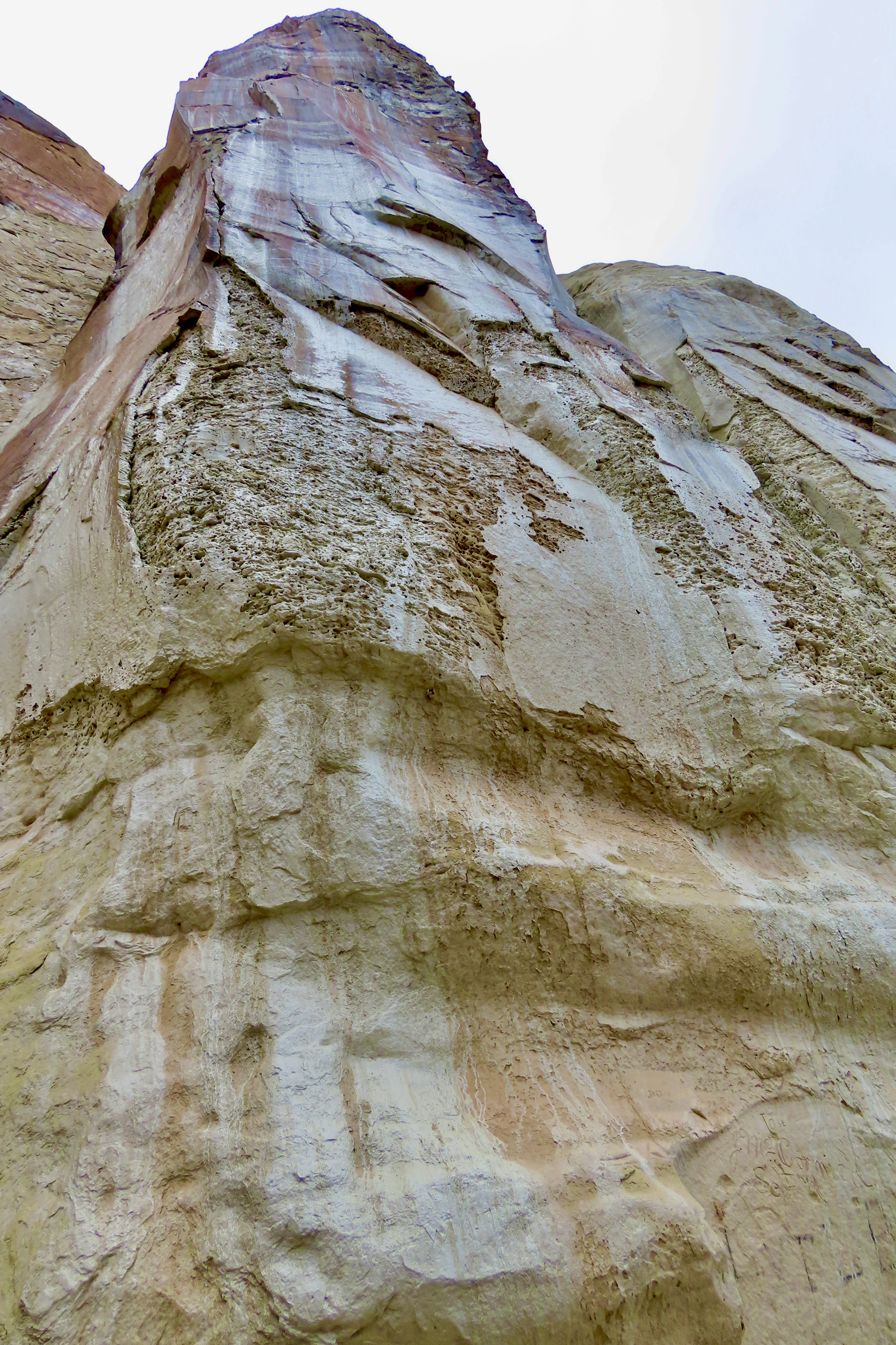
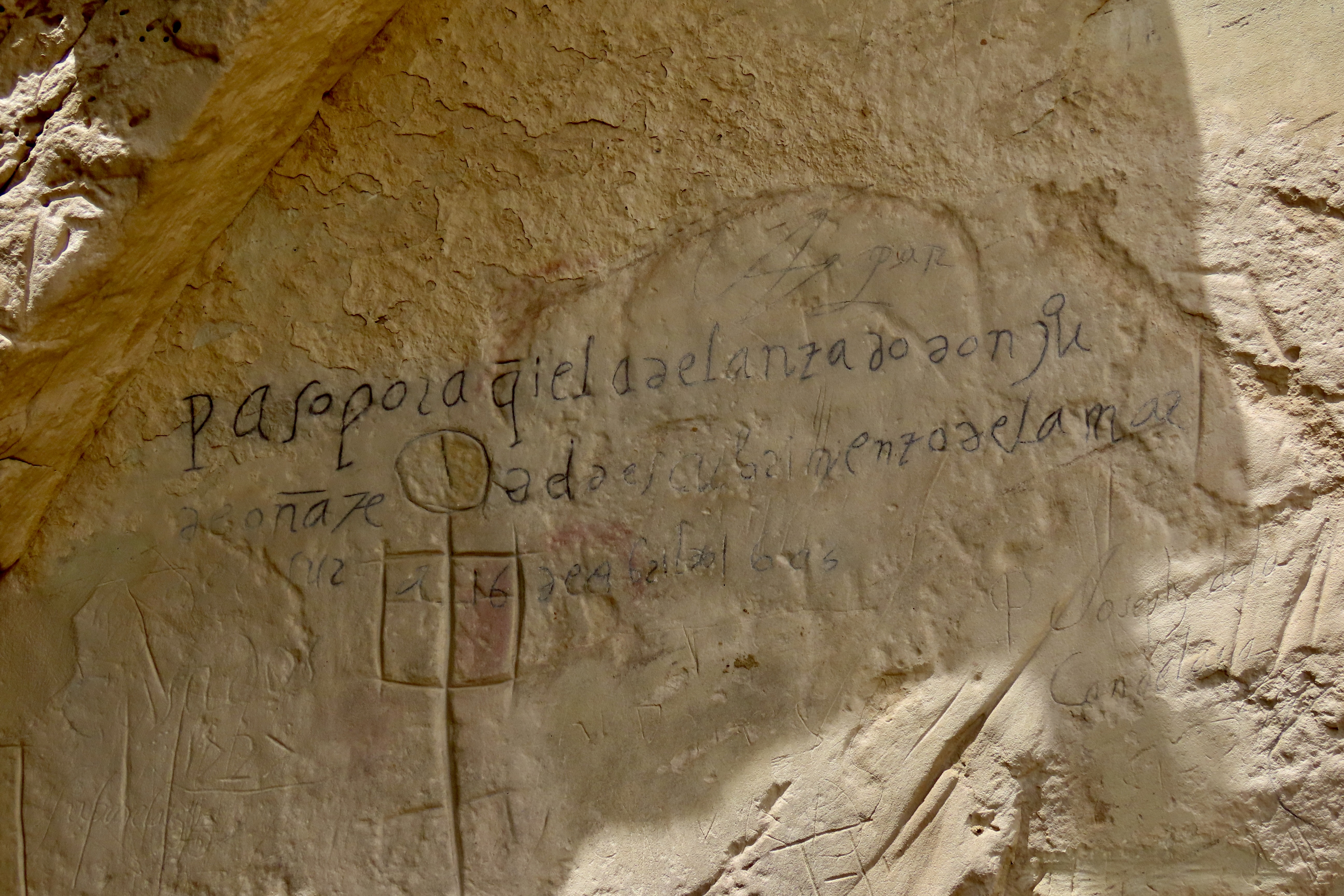
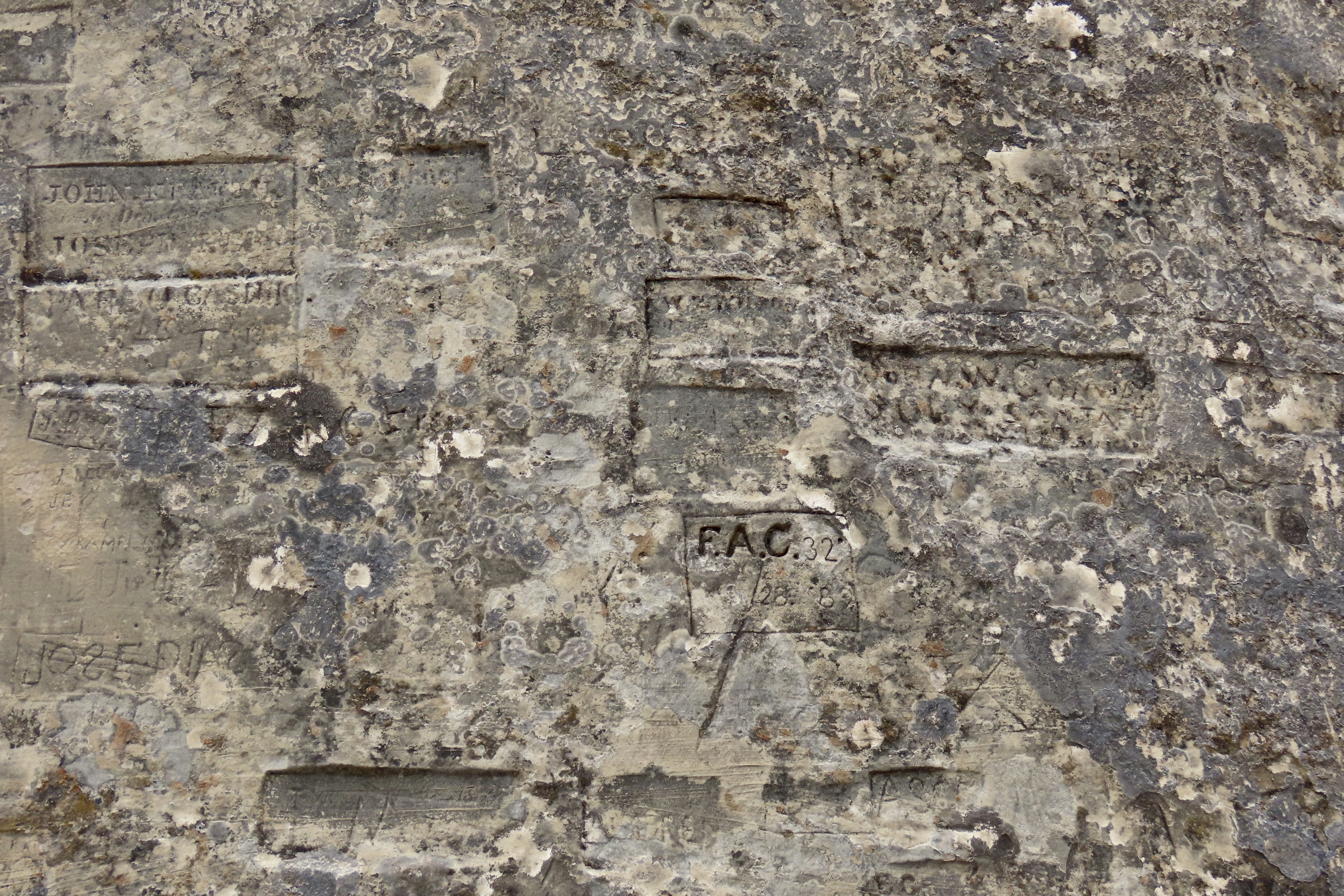
This was our view of El Morro as we approached the National Monument on Highway 53 ( the Trail of the Ancients) from Grants,New Mexico. The Spaniards gave El Morro its name, which translates as a promontory or headland. Geologically speaking, El Morro is a cuesta with a sharp, steep face on one side and a gentler slope on the other. I was interested in the white top you can see on the left (more on that later). The signatures and petroglyphs started to the left of the two Ponderosa pines where the waterhole is and extended along the base of the cliff to around the corner.Like most national park and monument visitor centers, El Morro’ was beautifully designed to fit into its environment. (Note: Peggy and I made two visits to the Monument: One to check out the petroglyphs and signatures, and two, to hike up to the top and explore the Atsinna Pueblo. That’s why our photos include cloudy and relatively clear skies.)The low profile of the building provided excellent views of the main attraction. We were eager to explore, but first we stopped at the Visitor Center…Where we were greeted by staff with welcoming smiles and a ton of information they were eager to share about the monument. Both staff and displays are vital to enhancing the national park/monument experience. The illustration is what Atsinna Pueblo on top of El Morro would like if fully excavated. Note Peggy’s new haircut. El Morro is only open five days a week. That may be because of the Trump Administration’s cuts in staff.An easy, paved trail leads from the Visitor Center over to the water hole, petroglyphs and signatures.The waterhole is at the bottom the bottom of the hill behind the fence. The cliff above the pool is about 200 feet high. A large rock with a ponderosa pine stands on top.This impressive rock monument stood to the left of the pool. We imagined an Ancestral Puebloan looking down at us.It’s hard to believe that this pool of water surrounded by cattails could play the significant role it has. But the fact that it holds up to 200,000 gallons of water and doesn’t run dry made it a treasure for everyone from the Ancestral Puebloans in the 1200s to cattlemen in the 1900s. Up until 1961, it even provided water for the monument headquarters and visitor center. At first it was thought that the water was provided by a spring. Actually it is fed by runoff from the top. The dark stains on the side (desert varnish) are left behind by minerals in the water such as manganese.I’ve always liked cattails. One of my favorite hangouts in my unsupervised youth was a small pond about 1/3 filled with cattails. When the heads reached this stage, I would break them off with a portion of their stem, shake them vigorously, and send their aerial seeds flying off in all directions!We thought looking up at the desert varnish provided an interesting perspective. I believe the section that is missing was a rockfall in 1942 that filled the waterhole and had to be cleaned out.We were quite curious about this boulder embedded in the sandstone above the spring. While the timing was off in terms of when the sandstone was created, it looked like a petrified tree stump. We were at Petrified Forest National Park last week. This was one of many petrified logs we saw.A cliff swallow’s concept of a pueblo! They make their nests above the waterhole. In addition to being a safe location, the insects that live around the waterhole provide a convenient supply of food for feeding squawking, hungry chicks.Leaving the waterhole, we hiked along the path at the base of the cliff checking out signatures along the way. (I’m saving the petroglyphs for my next post.)A close up.Looking up…I’ve selected Don Juan de Oñate to represent the many Spaniards that signed their names on the rock. He was the first. It was in 1605, 15 years before the Pilgrims landed at Plymouth Rock. Oñate was a Spanish conquistador, explorer and first Spanish governor (viceroy) of New Mexico. At some time, the signature had been written over with a black pen to make it more visible. The inscription translates “Passed by here, the adelantado Don Juan de Oñate from the discovery of the sea of the south the 16th of April of 1605.” The sea he discovered was the Gulf of California.I chose Breckinridge’s signature because he represents a fascinating footnote of American history: The US Camel Corps. In the mid 1850s a unique experiment was undertaken by the US Army to tackle problems created by the severe water shortage in crossing the Southwestern deserts. Some men were sent off to Africa to explore the possibility of using camels for transport. They came back with 33 and and 3 Arab handlers. After a period of training in Texas, a test expedition set off across the desert for LA. They passed by El Morro with Breckenridge in charge of the camels. The camels did well— much better than horses or mules. They could carry more weight, travel farther during a day, and get along without water for a significantly longer period of time. Unfortunately, the Civil War came along and the experiment was abandoned.People choose a variety of ways to display their names.Some signatures were scribbled, some quite beautiful, and some encased. Each represented a different life, a different story.The Monument has a brochure that provides information on some of the people who signed their names. RH Orton is one. He was a captain in the Federal forces during the Civil War. He may have been on his way home when he signed this. Later he would become an adjutant-general in the California National Guard. One could easily spend weeks researching the various names. I’m sure people have.
That’s it for today. Next, we will post about our trip up to the the Atsinna Pueblo and also explore the petroglyphs we found scattered among the signatures, predating them by 400 years. We will also include an interesting discussion we had with two Zuni Rangers working on the trail up to the Pueblo, Calvin and Valentino. (“I was born on Valentines Day,” Valentino told us.)Atsinna Pueblo.
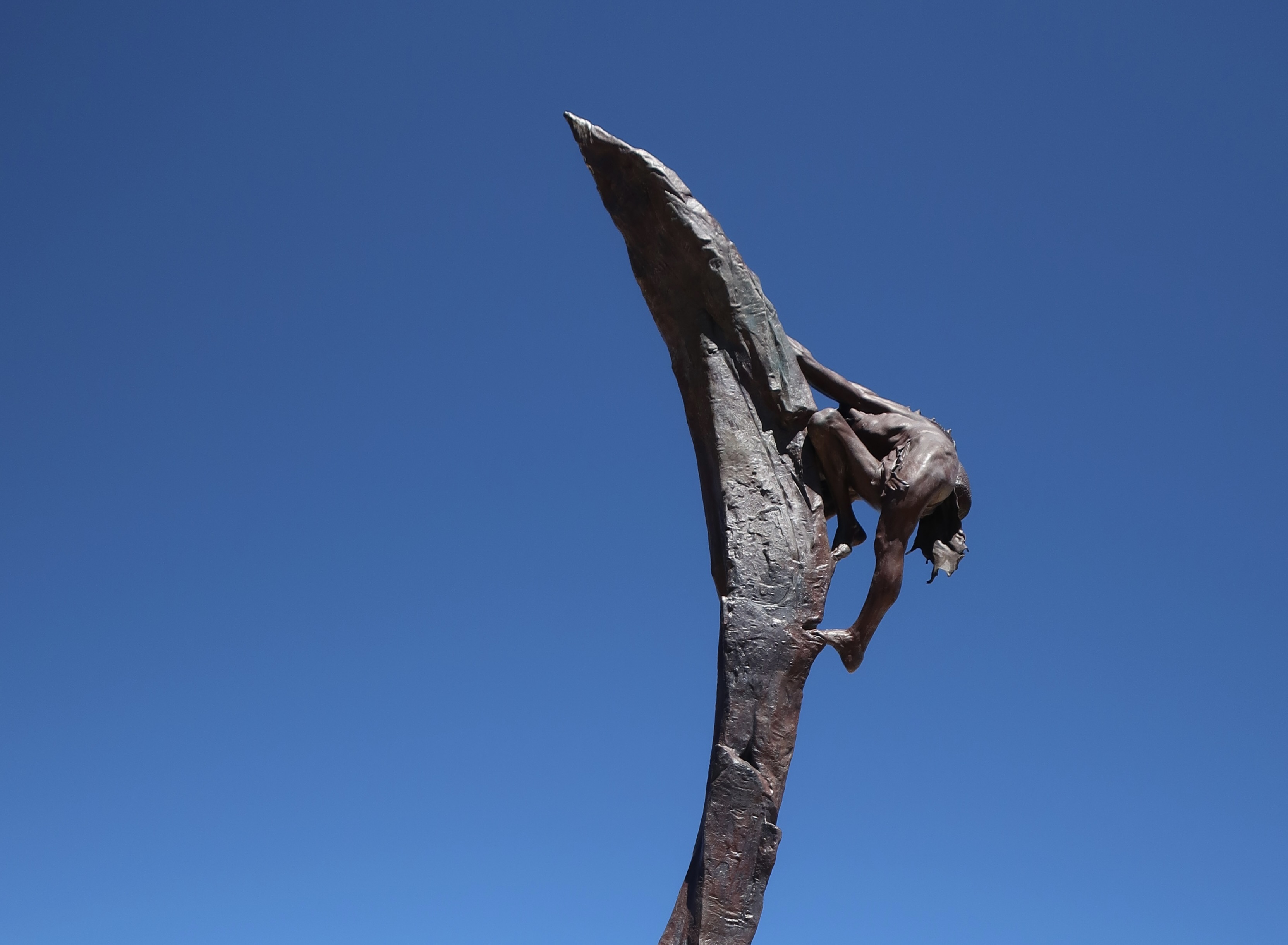
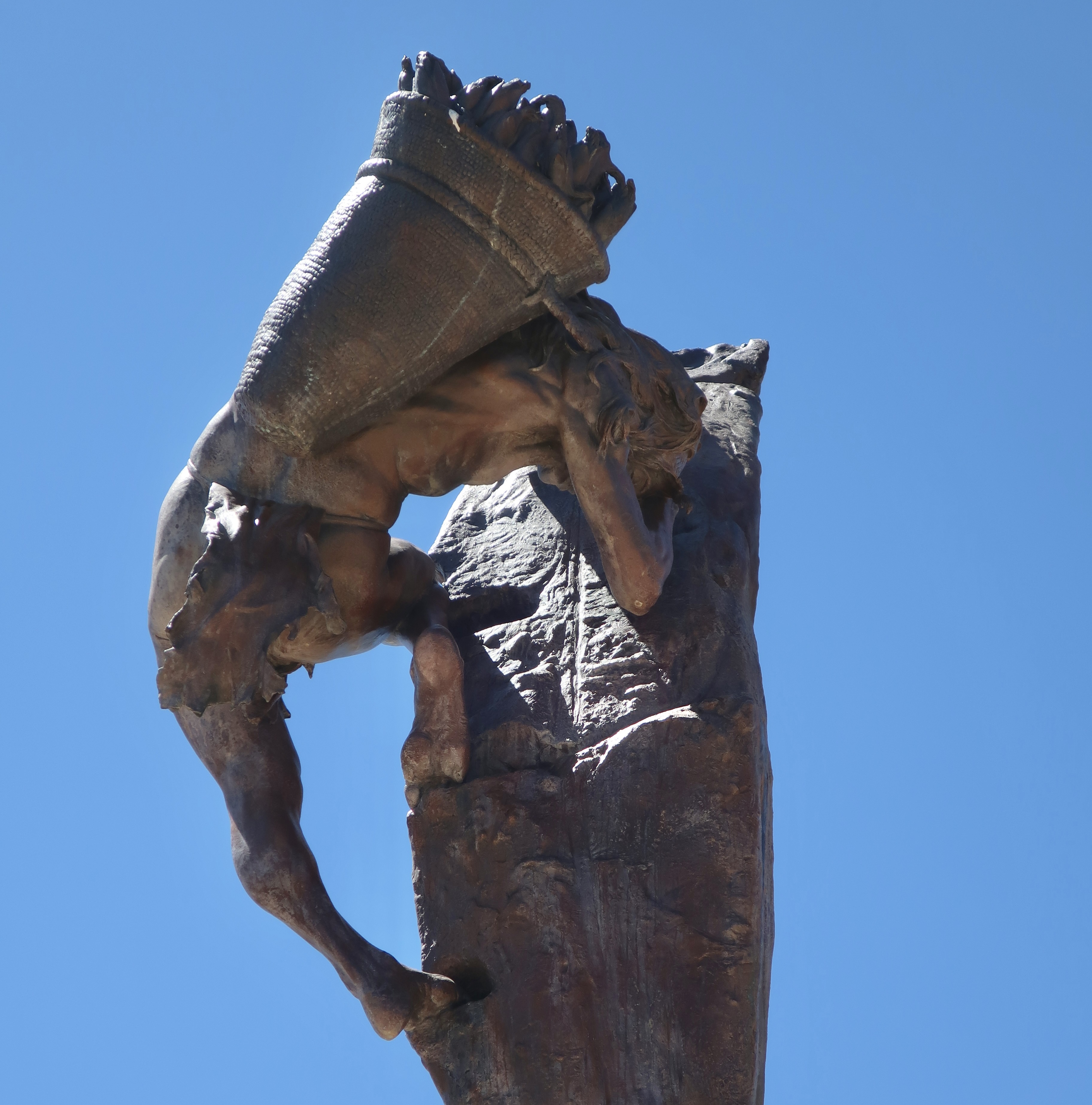
Normally, one would start a post on Mesa Verde featuring cliff dwellings. One of my earliest thoughts as a child about these magnificent structures, however, was how the inhabitants managed to get up to their homes perched high up on cliffs. This 22 foot bronze cast statue by Edward J. Fraughton at Mesa Verde dramatically illustrates the challenge. I couldn’t resist featuring it. Note the footholds, or maybe I should say, toeholds.Split level living at its best? It is thought that the Fire Temple complex at Mesa Verde was used for ceremonial purposes and possibly as living quarters for those who oversaw the ceremonies. It features these structures located on two different levels plus a large open area for ceremonies and meetings off to the left. The toe holds for climbing are clearly visible. Ladders that could have been raised or lowered would have extended below the toeholds: Lowered to get up to the second level under normal circumstances— or raised to frustrate an enemy if under attack.A close up of the toeholds. We wondered if the indentations on the right were used for handholds. Getting up or down would have been complicated by having to carry a load such as shown below when looking at the Ancient One’s statue from a different perspective.“Could you hold that pose while I finish the statue?” It looks like maize/corn in the basket, which was the primary crop of the Ancestral Puebloans. Other things that would have to be carried in addition to food would include water, babies, building materials and items for day to day living. I suspect that children learned to scramble up and down at a relatively young age.Peggy and I found these footholds climbing up a cliff in Zion National Park when we were searching for petroglyphs in a remote area. I thought I’d try climbing them. “Um, maybe not,” my companion suggested rather forcefully. I don’t think my offering to carry her would have made a difference.This is the meeting/ritualistic section of the Fire Temple. A large, raised fire pit is located in the center of the plaza. There is some speculation that the square vaults beside the fire pit may have been covered and used for drumming. I can imagine the people gathered here asking for rain, good crops, health, or protection from a marauding enemy. Or maybe they danced.
Ancestral Puebloans reached the Mesa Verde (“green table”) area sometime around 600 CE (A.D.). They would remain in the area for 700 years reaching the peak of their civilization between 1100-1300 CE. At first, they focused on building pithouses, pueblos, masonry towers, and farming structures on top of the mesa. The National Park Service features a number of the buildings. While we visited several of them, our focus today will be on the cliff houses for which Mesa Verde is famous. But first, a quick look at the countryside where the Puebloans chose to make their homes.
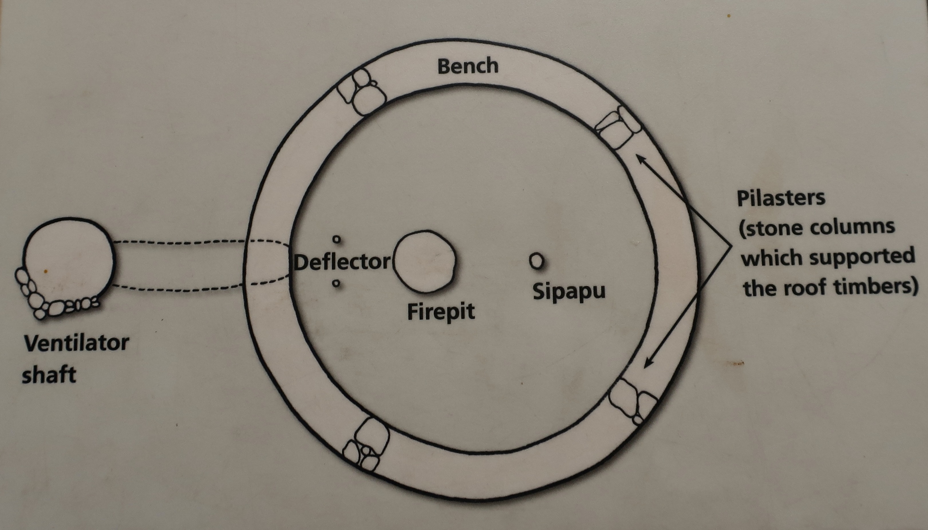
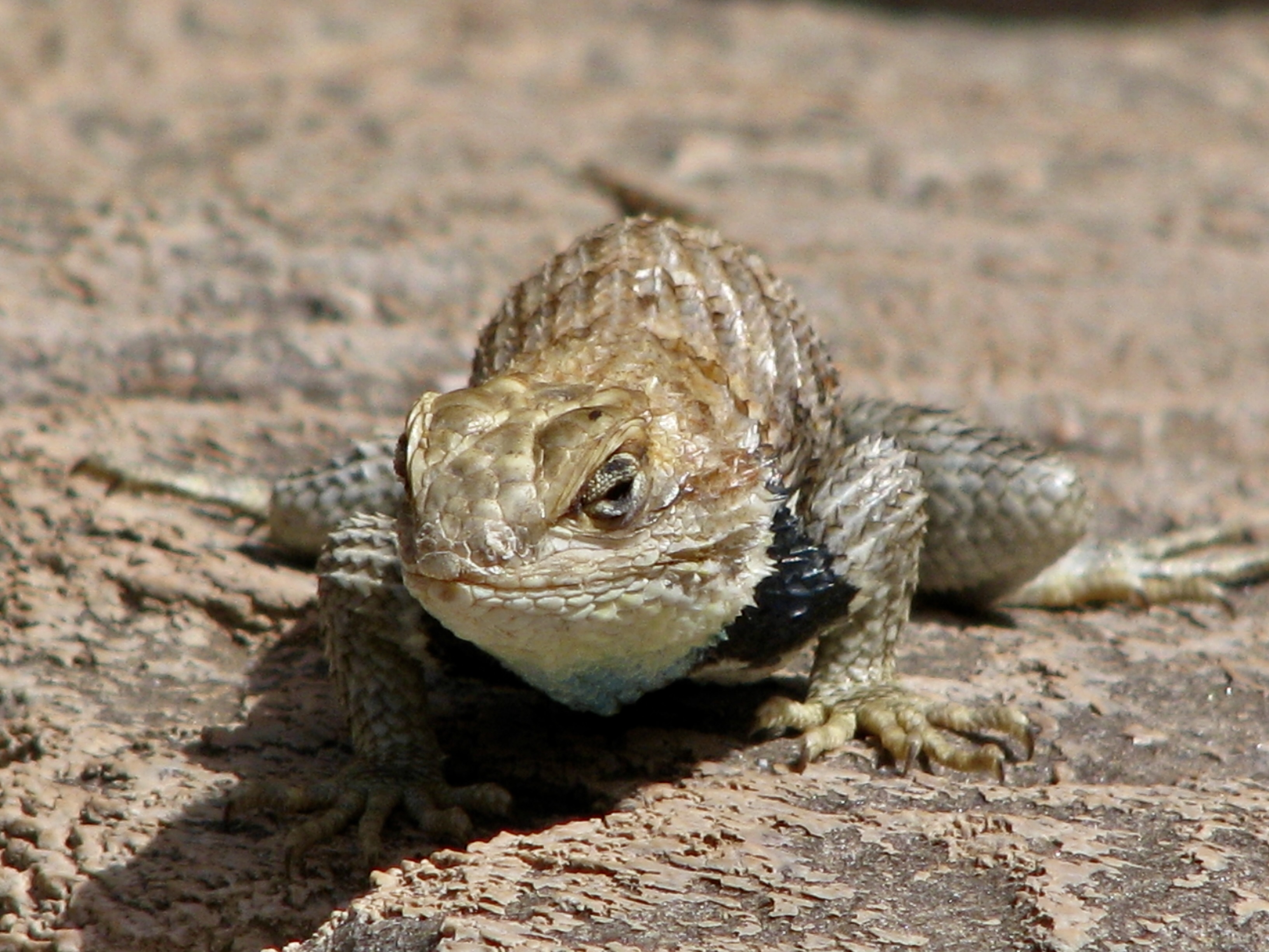
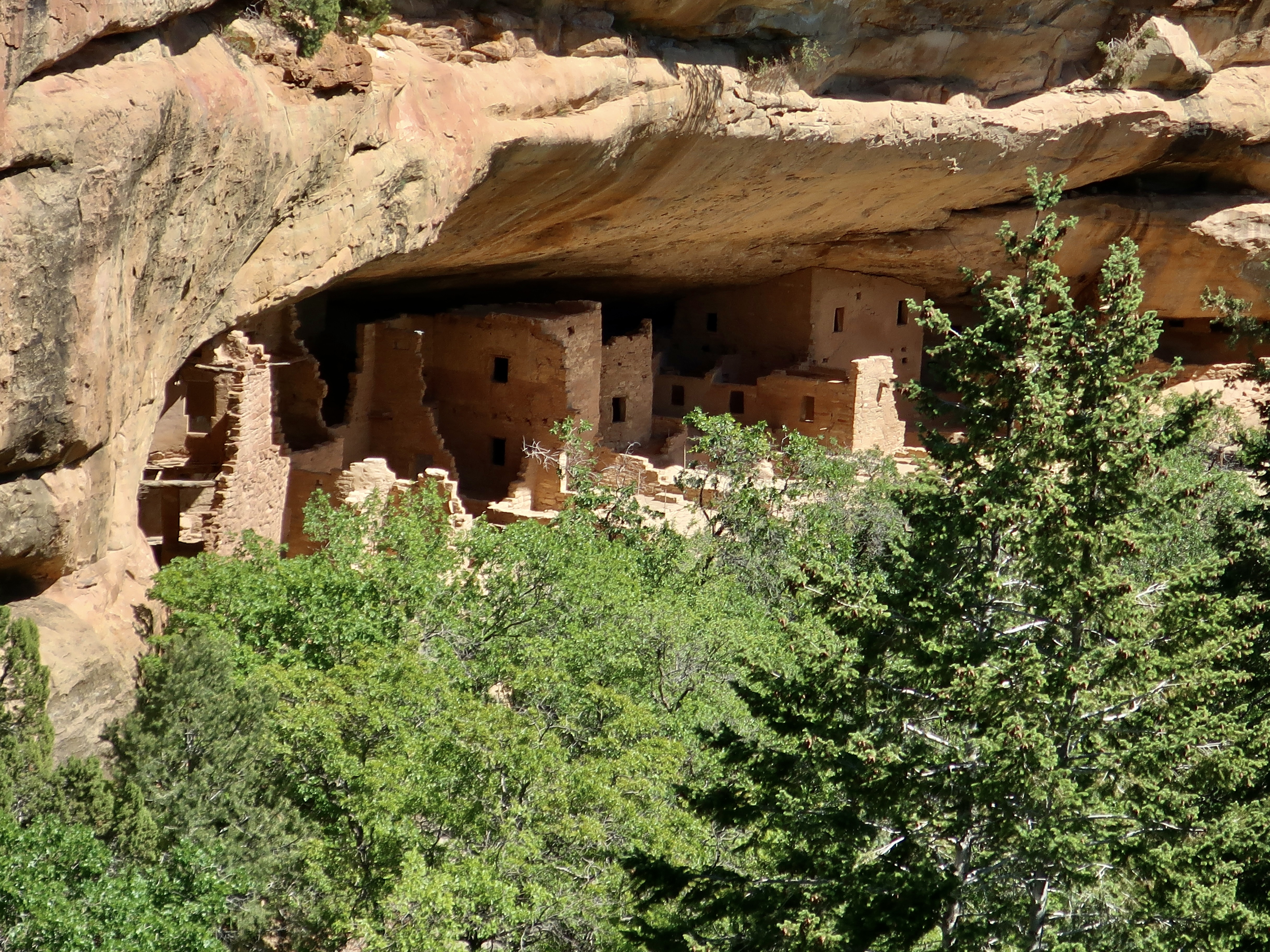
This prominent landmark overlooks visitors as they enter the park. The road works its way up from the lower left. It’s likely that the Ancestral Puebloans would have considered the mesa sacred.Mesa Verde translates as “green table.”A drive up to Park Point, the highest point in Mesa Verde at 8572 feet (2612 m), provides great views of surrounding valleys and distant mountains.Layered sandstone rocks like these provided sites for cliff houses. The distant mountain is known as Sleeping Ute Mountain.And now for three of the major cliff dwellings at Mesa Verde. This one, called Cliff Palace, is the largest cliff dwelling in North America. It has 150 individual rooms and 20 kivas. Kivas are round structures used for ceremonial purposes.This illustration of a kiva was on an information board at Mesa Verde. Most of it is self-explanatory, but you might find yourself asking, “What the heck is a Sipapu?” To the Ancestral Puebloans and their modern day descendants, the sipapu represents the opening through which their ancient ancestors emerged to enter this world as lizards and then changed into their human form.The Hopi believe that the entrance to this world was found on the Little Colorado River a few miles above where this photo was taken. We had stopped here when we were on our 18 day raft trip down the Colorado River through the Grand Canyon. I’ll be reposting blogs from that trip in a few weeks as Peggy and I are boating down the Danube River from Vienna to Budapest.Our friend Don Green, who was with us on the Colorado River adventure, found this fellow watching us from a ledge when we stopped off at the Little Colorado. Hmm.A closer look at the Cliff Palace. The Square Tower House, built in the mid 1200s CE, is the tallest structure in Mesa Verde. Standing at 27 feet (8 m), it is four stories high. Painted murals and petroglyphs are said to be located throughout the structure. Peggy and I have spent many happy hours searching for petroglyphs throughout the West and would have loved to have seen what was in the Square Tower. This might provide a clue. It is a replica of a big horn sheep petroglyph found at Mesa Verde’s Petroglyph Point. Unfortunately, we didn’t have the time for the 2 1/2 mile hike out to the point. This is a National Park Service photo of the petroglyphs found on Petroglyph Point. The sheep is upper center. To the right of it is a turkey and to the right of that, hands. Beneath it are women giving birth. All of these are common themes of petroglyphs throughout the West. I think the cat-looking creature on the far left is a mountain lion. I found it rather humorous. Are its front legs on backwards or is it eating a person? It may be that the animals in the panel represent various clans.Several other structures were located at the Square House cliff dwelling. Was the rock here originally and the Puebloans built around it? Or did Nature add it later?Another large rock was located at the Square House cliff dwelling in the kiva on the right. The same question about how it got there applies.This photo of the Square House cliff dwelling shows how shallow the dwelling was, and how it might be vulnerable to rock fall. Only the Square House seems totally protected.And finally, we come to the Spruce House Dwelling, which is located a short walk away from the Visitors’ Center. It is the third largest cliff dwelling found at Mesa Verde. Built between 1211 and 1278 CE, the dwelling holds 130 rooms and 8 kivas.Another perspective. It was first discovered by pioneers in 1888 when a pair of cowboys found it while they were searching for lost cattle. They climbed down what they thought was a large spruce tree to get in. Thus the name. (It was actually a Douglas fir that is now cut down.) I wonder if they took off their spurs? Below are three photos of the buildings at Spruce House.
Theodore Roosevelt established Mesa Verde National Park in 1906 to “preserve the works of man.” It was the first park of its kind designed to protect and maintain an important historical and cultural treasure. Located in Southwestern Colorado, the park covers an area of 52,485 acres.
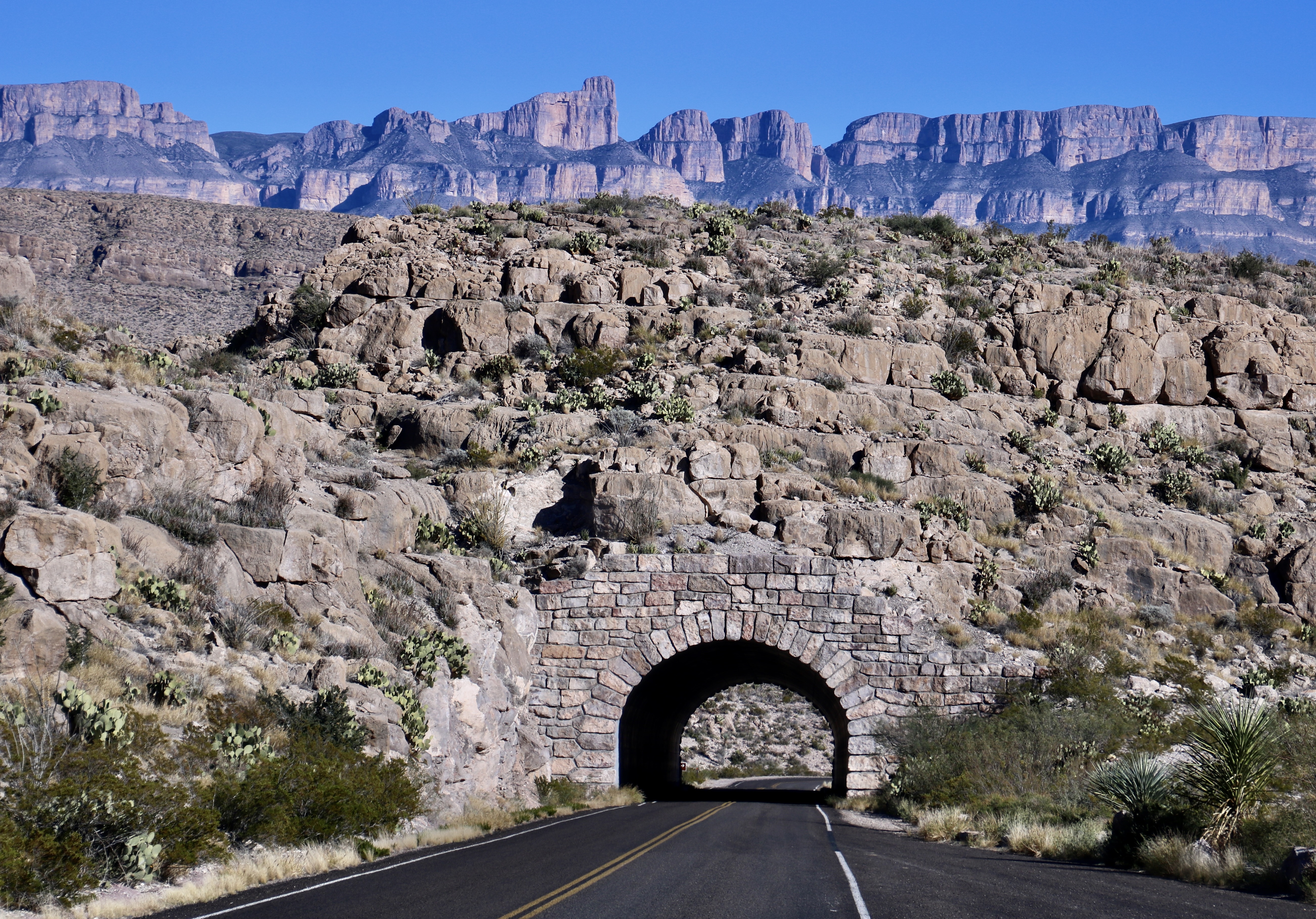
Our next post will take you to visit another national park of great natural beauty and relatively few visitors, Big Bend. It is located in southwestern Texas far from any major metropolitan areas.
Join us as we explore its desert beauty, starting Friday.