Arches… A Photographic Journey through America’s National Parks

Photo of stone sculpture and mountains in Arches National park. Photo by Curtis Mekemson.

Arches National Park is known for its soaring arches carved from stone, but that is only the beginning of its beauty.

One of our goals over the past several years has been to visit all of America’s National Parks. We’ve been to all 50 states in pursuit of this objective. There are a couple in Alaska still on our “to do list.” Since Peggy and I are presently wandering in Mexico, I’ve recruited some of our favorite National Park photos to fill in while we are gone. Enjoy.

Arches National Park is located in eastern Utah. While the towering rock arches are indeed striking, other rock sculptures are equally, if not more, impressive.

Stone sculptures at Arches National Park. Photo by Curtis Mekemson.

These stone sculptures stand like sentinels.

Shadow outlines of rock sculptures at Arches National Park. Photo by Curtis Mekemson.

With dark rapidly approaching, only shadowy outlines could be seen. I am thinking the Three Wise Men.

Wall of stone at Arches National Park. Photo by Curtis Mekemson.

This wall of stone greets visitors upon their arrival to Arches National Park. (Photo by Peggy Mekemson.)

Family of rock sculptures at Arches National Park. Photo by Curtis Mekemson.

I thought of this collection of rock sculptures as a family… Mom and the kids.

Sedimentary layers shown at Arches National Park. Photo by Curtis Mekemson.

This collection shows different sedimentary rocks laid down in ancient times.

Rock sculpture at Arches Natioal park. Photo by Curtis Mekemson.

Another photo that captures sedimentary layers and shows the impact of weather on various rocks. Different rocks erode at different speeds, thus creating the wonderful sculptures seen throughout the Southwest..

Evening sun turns a rock sculpture red in Arches National Park. Photo by Curtis Mekemson.

Caught in the evening sun.

Photo of joining arches at Arches National Park. Photo by Curtis Mekemson.

Naturally, any photo essay on Arches National Park has to include some arches.

Two arches at Arches National Park. Photo by Curtis Mekemson.

The same arch caught 30 minutes later.

Under and arch at Arches National Park. Photo by Curtis Mekemson.

Looking up from under the arch. I knew the rock was solid but still felt nervous.

Arches National Park photo by Curtis Mekemson.

A final arch.

NEXT BLOG: We will head west to Yosemite National Park.

Bolinas: A Recluse Kind of Town… Pt. Reyes National Seashore

Mural of early Bolinas, California. Photo taken by Curtis Mekemson.

A mural depicting how Bolinas would have looked in the 50s. Not much has changed. The artist added a touch of humor with the blue surfboard the man in the brown sports coat is carrying.

Marin County had a problem. Its highway department would put up a sign on Highway 1 pointing west toward the town of Bolinas and the residents of the small coastal community would tear it down. Again and again. Located 30 miles north of San Francisco and just south of Pt. Reyes National Seashore, the town didn’t want anyone to know where it was; the town was a recluse.

Finally, out of frustration, Marin County held a vote: Did or did not the townspeople want the signs? They voted no. Today, nothing points toward the community. But a map or GPS will get you there.

I first made my way to Bolinas in the early 70s. Surfers, hippies, commune members, artists, writers and other alternative types called it home. I was running an environmental center in Sacramento at the time. Being ex-Berkeley and ex-Peace Corps, I more or less fit in. “I could live here,” I thought to myself.

The town was also known for its nude beach. I won’t incriminate myself other than to note that there are some places on the body it’s best not to get sunburned.

Ken, Leslie, Peggy and I made our way to Bolinas after we left Pierce Ranch. Other than a new park in the middle of town, I was happy to find that the community had changed little. The park, I was proudly informed by a shop owner, had been donated by one of the town’s billionaires. Big money had found its way to this small community, which is pretty much the story of Marin County. Extreme wealth and a laid back lifestyle go hand in hand. In Bolinas, VW Vans and BMW’s seemed to happily co-exist.

We wandered through town poking our heads in various shops and looking for a bookstore. It’s become a tradition whenever we travel. We love books and we like to support local bookstores. We found one on the edge of town next to the post office. It was quite unique; the owner was elsewhere and shoppers were invited to price their own selections. Seven suggested categories ranged from “unbelievably really great” for $20 to “ordinary” for a buck. It was possible (though not likely) that Peggy’s really great might be my ordinary. A small, metal box with a slot on top was set up for payment. A statue of the Virgin Mary fronted the box. I wasn’t sure whether she was there to say thank you or to haunt our conscience if we paid five bucks for a book we believed was worth ten.

Bolinas, California unique book pricing recommendations. Photo by Curtis Mekemson.

A sign with suggested prices for books in Bolinas, California that depended on your assessment of the book.

Bolinas Book Store photo by Curtis Mekemson.

Ken deposits $5 for a “great book” in the Virgin Mary box while Peggy, reflected in a mirror, looks on.

Bolinas, California  book store photo by  Curtis Mekemson.

I assume this was the missing owner’s office. I believe he painted the pictures.

Leslie, Ken and Peggy stand in front of the Bolinas Bookstore named Books.

Leslie, Ken and Peggy stand in front of the Bolinas Bookstore named Books.

Our visit also included stopping off at a stuffed-to-the-ceiling antique store, admiring quaint houses that had been around since day one, taking photos of murals and visiting a small shop featuring incense, eastern music, and a Humpty-Dumpty Buddha.

Photo of Bolinas California taken by Curtis Mekemson.

Bolinas today, which I did in black and white to give it a 70’s feeling. Take away the cars and the billboard building and you’ll find the Bolinas featured in the mural at the top of the post.

The Grand Hotel Shop and Gallery in Bolinas, California. Photo by Curtis Mekemson.

The Grand Hotel Shop and Gallery was stuffed top to bottom with antiques.

Mannequin in Bolinas, California. Photo by Curtis Mekemson.

I was intrigued with this aging mannequin I found looking out the window of the shop.

A home in the town of Bolinas, California. Photo by Curtis Mekemson.

The old homes in town have aged well.

Back in a hot-flash sign in Bolinas, California. Photo by Curtis Mekemson.

Incense, Eastern music, and this sign pulled us into a shop.

Eclectic Bolinas, California shop. Photo be Curtis Mekemson.

The laughing Buddha face on the upper left shelf made me think of Humpty Dumpty. The items in the shop were, um, eclectic…

Inside of shop in Bolinas California. Photo by Curtis Mekemson.

Very eclectic.

Bolinas Shrine. Photo by Curtis Mekemson.

We found a shrine next door that the community had put up after 9/11.

Surf shop ad in Bolinas, California. Photo by Curtis Mekemson.

A Bolinas surf shop advertised using broken surf boards featuring Native American/First Nation art.

Halloween pumpkin in Bolinas California. Photo by Curtis Mekemson.

This pumpkin reminded me that Halloween had just passed…

2013 gas prices in Bolinas, California. Photo by Curtis Mekemson.

And this sign reminded me that we would be buying our gas elsewhere. This station matched what I was paying in the Yukon territory this summer.

NEXT POST: Peggy and I heading off to Mexico for three weeks. To fill in, I’ve decided to put up photos that Peggy and I have taken in America’s National Parks. We’ve made a point of visiting close to all of them. I’ll close out my Pt. Reyes’ series with a Bolinas mural that I think reflects the area: ocean, wilderness, and a touch of magic.

Mural of mountain lion and mermaid in Bolinas, California. Photo by Curtis Mekemson.

Socrates Digs South Beach… Pt. Reyes National Seashore

Photo of Socrates the Basset Hound by Curtis Mekemson

Socrates the Basset Hound fell in love with digging opportunities at South Beach, Pt. Reyes National Seashore.

Peggy and I didn’t make it out to North and South Beach this time. Three days were not nearly enough to visit all of my favorite Pt. Reyes sites. I have a few photos from my pre-blogging days, however, so I decided to do a quick post.

These two beaches are actually one. If you enjoy crashing waves and long, lonely beach walks, this is the place to go. I still remember my first hike along the shoreline. My companion at the time was a long-eared, short-legged basset hound named Socrates.  It was before leash laws were established so the dog ran free over the sand. Sort of– Basset hounds aren’t noted for their long, graceful gaits.

For example, Soc loved to chase jackrabbits. The only time I ever saw him catch one was when the rabbit was rolling on the ground and laughing so hard he couldn’t escape. (Kidding.)

But there was another reason for our slow progress down the beach. Soc had a passion for digging. He could move more dirt in an hour than a bulldozer could in a day. (Slight exaggeration.) Given what he could do with dirt, you can imagine what he did with the sand. I was hoping for a high tide to hide his destruction.

When I urged the Soc to stop hassling whatever poor creature he was after, he whined and start digging harder. I was in danger of being buried under an avalanche of sand. The dog had Zen-like focus; it didn’t matter that he never caught anything. I’d get him away from one hole and he would start another 50 feet down the beach. Our slow progress made for a long walk but it was totally worth it for the joy the dog found in digging holes and the pleasure I took in watching him and, of course, the beautiful Pacific Ocean.

Waves at South Beach, Pt. Reyes National Seashore. Photo by Curtis Mekemson.

Waves come crashing in at South Beach.

Years later I discovered that North Beach was a great place for writing. I would park facing the ocean, get out my laptop, and start typing. The rolling ocean, an occasional whale, diving pelicans and raucous gulls served as my muses.

Photo of waves at South Beach, Pt. Reyes National Seashore. Photo by Curtis Mekemson.

Another thunderous wave.

Ice plant at South Beach, Pt, Reyes National Seashore. Photo by Curtis Mekemson.

This ice plant formed the border between the parking lot and the beach.

Close up of ice plant at South Beach, Pt. Reyes National Seashore.

It demanded I take a close up.

Raindrops captured by lupine leaves at South Beach, Pt. Reyes National Seashore. Photo by Curtis Mekemson.

These lupine leaves displayed captured rain drops.

Iris growing near South Beach, Pt. Reyes National Seashore. Photo taken by Curtis Mekemson.

I also found this iris quite attractive.

The winds at North and South beach provide excellent loft for kite flying. I enjoyed the dragon but it distracted me from my writing.

The winds at North and South beach provide excellent wind for kite flying. I enjoyed this dragon but it distracted me from my writing. I wonder what the gulls thought about it?

Tules near North Beach, Pt. Reyes National Seashore.

I discovered these tules on Bull Point trail near North Beach. Miwok Indians used these plants in making baskets.

NEXT BLOG: The hippie town that tries to hide: Bolinas. Here’s a final photo of South Beach.

Waves pound the beach at South Beach, Pt. Reyes National Seashore. Photo by Curtis Mekemson.


The Historic Pierce Ranch and a Herd of Tule Elk… Pt. Reyes National Seashore

Lichens found on a fence on Pierce Ranch at Pt. Reyes National Seashore. Photo by Curtis Mekemson.

Lichens, adorning a fence on the historic Pierce Ranch at Pt. Reyes National Seashore, remind visitors that it has been 46 years since the last cow mooed.

Marin County land speculators, real estate firms, and local governments had a dream in the 1950’s. They were going to turn Pt. Reyes into one vast housing tract. Mouth-watering profits were to be made. Local tax dollars would increase proportionately. Everyone would gain.

Well, not quite.

Local ranchers saw a life style they had loved for over a century disappearing. The Sierra Club saw one of the world’s richest natural environments falling under the blades of bulldozers. The National Park Service saw it’s dream of opening the beautiful coast and forests of the area to the public being replaced by a forest of no trespassing signs.

An alliance was formed. Environmentalists and ranchers joined together with visionary local and national leaders to devise a plan that would protect the environment, allow ranchers to continue ranching, and give the National Park Service the opportunity to create one of America’s premier parks, a gift to America and the world that would last for generations. In 1962, John Kennedy signed the legislation that would create the Pt. Reyes National Seashore.

The Pierce Ranch, located out on Tomales Point, ceased operation in 1973. Three years later it became part of the park as a historic representative of the dairy ranches at Pt. Reyes that had been milking cows and shipping butter to the Bay Area since 1866.

In 1978 a herd of Tule Elk was reintroduced to the area as part of the Tomales Point Tule Elk Reserve. Native to California, Tule Elk had once roamed throughout the state in substantial numbers. By 1900 they were close to extinction. Saved by a Bakersfield rancher, over 20 protected herds are now located in California.

Photo of a lichen covered fence at Pt. Reyes National Seashore.

Another photo of the lichen covered fence. It’s like a strange forest.

Photo of cypress tree wind break on Pierce Ranch inPt. Reyes National Seashore. Photo by Curtis Mekemson.

Possibly the mother of all cypress tree windbreaks stands above Pierce Ranch.

Photo of barn at Pierce Ranch, Pt. Reyes National Seashore.  Photo by Curtis Mekemson.

A number of buildings make up the ranch, including this old barn.

Photo of one-room school house at Pierce Ranch, Pt. Reyes National Seashore including Leslie Lake and Peggy Mekemson. Photo by Curtis Mekemson.

Isolated out on Tomales Point, Pierce Ranch formed a small community that included a store and this school-house. Since our friend Leslie Lake spent many years as a third grade teacher and Peggy worked as an elementary school principal, I’ve included them in the photo.

Looking inside school at Pierce Ranch on Pt. Reyes National Seashore. Photo by Curtis Mekemson.

Once filled with laughing children learning their abc’s, the school is now vacant and the windows are covered with cobwebs– ghostly reminders of the past.

Old cattle pen at Pierce Ranch at Pt. Reyes National Seashore. Photo by Curtis Mekemson.

Once upon a time cattle would have been penned up within these fences, ready to be loaded on to trucks using the blocked ramp at the top of the photo.

Aging fence at Pierce Ranch, Pt. Reyes National Seashore. Photo by Curtis Mekemson.

A close up of the fence.

Bunk house at Pierce Ranch on Pt. Reyes National Seashore. Photo by Curtis Mekemson.

This small bunk house would have accommodated ranch hands. Up to 20 were employed at the height of milking season.

Photo of dairy house at Pierce Ranch, Pt. Reyes National Seashore by Curtis Mekemson.

This dairy house was where butter was prepared to be shipped off to San Francisco in large kegs. Butter from Pt. Reyes was considered to be very high quality and was sold in gourmet shops and used in the best restaurants.

Old farming equipment at Pierce Ranch on Pt. Reyes National Seashore. Photo by Curtis Mekemson.

What’s a farm without equipment? This piece had morphed into a planter.

Close up of old farm equipment at Pierce Ranch on Pt. Reyes National Seashore. Photo by Curtis Mekemson.

A close up.

Old soil tiller at Pierce Ranch, Pt. Reyes National Seashore. Photo by Curtis Mekemson.

This tiller also caught my attention.

Rusted gear and chain on soil tiller at Pierce Ranch, Pt. Reyes National Seashore. Photo by Curtis Mekemson.

Rusted gear teeth and chain on tiller.

Tule Elk grazing on a hill at the Tule Elk Preserve at Pt. Reyes National Seashore.

Having toured Pierce Ranch we climbed the hill next to the ranch in search of Tule Elk. We found them a long ways off. (Photo by Peggy Mekemson.)

Photo of bull Tule Elk at Pt. Reyes National Seashore Tule Elk Reserve. Photo by Curtis Mekemson.

Here’s how one looked a little closer.

NEXT BLOG: North and South Beach where the Pacific Ocean crashes ashore. Here’s a final shot of the Tule Elk. One of the big guys had obviously taken an interest in me. I was hoping it wasn’t personal. –Curt

A pair of Tule Elk at Pt. Reyes National Seashore. Photo by Curtis Mekemson.

Limantour Beach: A Wild World… Pt. Reyes National Seashore

Shore, sea and sanderlings meet on Limantour Beach at Pt. Reyes National Seashore. (photo by Peggy Mekemson.)

Shore, sea and Sanderlings meet on Limantour Beach at Pt. Reyes National Seashore. (Photo by Peggy Mekemson.)

A steep ridge runs most of the length of Pt. Reyes National Seashore. The road to Limantour Beach is all business as it climbs up and over. Who needs switchbacks? A sign tells trailers to stay off. Our van Quivera has made the journey several times but always complains. Our friend Ken Lake’s truck laughed at the challenge.

The journey across provides an introduction to most of Pt. Reyes’ ecological zones.  Seeing a Kodak moment, I asked Ken to stop up on top. Fog and sun were battling with each over who would rule the day. Grass, brush, trees and canyons joined the drama. I searched the canyon for wildlife to add to my photo. Tule Elk and Black Tail Deer are commonly seen during the day, as are hawks and omnipresent buzzards. Nothing presented itself. All I found was some aging, hair-filled bobcat scat (poop) with a pile of fresh raccoon scat on top. I figured the raccoon was making a statement. I also figured that the scat didn’t need to be part of my photo. (“Good decision,” Peggy adds.)

Pt. Reyes photo along Limantour Road at Pt. Reyes national Seashore by Curtis Mekemson.

Sun and fog were part of the landscape in this photo I took from Limantour Road.

Pt. Reyes Natioanl Seashore photo by Curtis Mekemson.

Looking south from Limantour Road at where the deer and elk roam.

The road down to Limantour Beach is almost as steep as the road up and one section would scare a roller-coaster. Topping the last hill provides a broad view of Drake’s Bay, Limantour Beach and the Limantour Estero. A long narrow spit separates the Bay from the Estero. I suspect the view isn’t tremendously different from what Sir Francis Drake would have found when he sailed into the Bay in 1579, the first European to visit the area. Miwok Indians, who had called the region home for thousands of years, greeted the British explorer/noble/naval hero/pirate.

We parked the truck, crossed a walking bridge over the Limantour Estero, hiked down to the beach and walked north along the shore. Sea gulls, Sanderlings, crab shells, driftwood, animal tracks, sunning buzzards, gentle waves and distant vistas entertained us.

Bags provided for picking up trash on Limantour Beach at Pt. Reyes National Seashore. Photo by Curtis Mekemson

A great idea: The National Park Service provided bags so people could pick up trash as they walked along the beach. Ken immediately grabbed one and we all helped fill it. Note: Ken never lets anyone doubt his team loyalty.

Estero de Limantour at Pt. Reyes National Seashore. Photo by Curtis Mekemson.

A bridge provided a view up the Limantour Estero or estuary. Estuaries are where fresh and ocean water mix, creating a rich environment for fish and birds. The Pt. Reyes headlands in the distance offers a great vantage point for whale watching. It is also home to Pt. Reyes’ Elephant Seal population.

Elephant seal photo by Curtis Mekemson.

I love elephant seals. These magnificent creatures spend the majority of their lives at sea and 90% of that time under water. They travel thousands of miles annually and can dive up to 2000 feet deep. This photo came from a blog I did about the Elephant Seals of Piedras Blancas.

Photo of the Estero de Limantour at Pt. Reyes taken by Curtis Mekemson.

Another view of the Limantour Estero, this one from the spit that separates the Estero from Drake’s Bay.

Limantour Beach at Pt. Reyes National Seashore.

Looking north up Limantour Beach across Drakes Bay. Sir Francis Drake named the area Nova Albion, New England, probably because the sandstone cliffs reminded him of the Cliffs of Dover. (Photo by Peggy Mekemson.) The small mounds or sand dunes are created by plant matter.

Looking south on Limantour Beach at Pt. Reyes National Seashore. Photo by Curtis Mekemson.

A lone person walks south on Limantour Beach.

Sea gulls on Limantour Beach at Pt. Reyes National Seashore. Photo by Curtis Mekemson.

Sea gulls tend to walk away when you get near them. I was encouraging these guys to fly. The one nearest appeared ready to leap into action.

Sea gulls in flight on Limantour Beach at Pt. Reyes National Seashore. Photo by Curtis Mekemson.

I finally succeeded.  I like the way this photo captures the different wing action of gulls in flight.

Sanderlings on Limantour Beach at Pt. Reyes national Seashore.

Meanwhile, Peggy was off checking out the seemingly endless flock of Sanderlings. (Photo by Peggy Mekemson.)

Flock of flying Sanderlings at Limantour Beach, Pt. Reyes National Seashore.

Who also decided to fly. How do they avoid winging each other? (Photo by Peggy Mekemson.)

Buzzards drying out wings on Limantour Beach at Pt. Reyes National Seashore. Photo by Curtis Mekemson.

“Check out the buzzards,” Ken urged. A pair were perched on top of a pine tree drying out their wings from the morning’s fog in preparation for flight.

Buzzards dry wings at Pt. Reyes National Seashore.

Using her telephoto lens Peggy got up close. Note their heads. They are naked so buzzards can dip into dead treats without getting their feathers involved. Isn’t evolution grand? (Photo by Peggy Mekemson.)

Buzzards feathers gor awry on Limantour Beach.

As we approached one got excitable. I think you might say he was having a bad feather day. (Photo by Peggy Mekemson.)

Raccoons leave tracks on Limantour Beach, Pt. Reyes National Seashore. Photo by Curtis Mekemson.

While animals were hiding out for the day, their tracks were abundant. Here, a family of raccoons made their way back to their home on the spit. Peggy and Leslie followed the tracks to what they decided was their home hidden in the brush.

Crab claw showing teeth on Limantour Beach at Pt. Reyes National Seashore. Photo taken by Curtis Mekemson.

It’s possible that crab was on the menu that night for the raccoons. We found numerous empty shells along the beach. I liked the teeth in this claw.

Empty crab shell found on Limantour Beach at Pt. Reyes National Seashore. Photo taken by Curtis Mekemson.

Empty crab shell. Many other birds and animals join raccoons in feasting on the oceans offerings. I also found a set of fox tracks leading down to the beach.

These tracks represent a virtual freeway into the grass on the spit.

These tracks represent a virtual animal freeway between the sand of the shore and the protective grass and brush of the spit.

Photo by Curtis Mekemson of driftwood on Limantour Beach at Pt. Reyes National Seashore

The grain of the wood exposed by the relentless pounding of the ocean is what attracts me to driftwood. We found a prime example on the upper beach at Limantour. A tree had been driven upside-down into the ground and was showing off its roots. I was curious about whether man or nature had been responsible for the upending.

Close up photo of driftwood on Limantour Beach taken by Curtis Mekemson.

A close up of the driftwood with its marvelous twists and turns plus two peek-a-boo holes.

Photo of spit on Limantour Beach by Curtis Mekemson.

We walked back to the parking lot following a trail along the spit.

Photo of grass on Limantour Spit taken by Curtis Mekemson.

Much of the trail made its way through the thick golden grass that dominates the spit and provides a home for Limantour Beach’s wild world.

NEXT BLOG: It’s off to the historic Pierce Ranch and a search for Pt. Reyes’ magnificent Tule Elk. I’ll conclude today’s blog with a black and white photo of gentle waves lapping up on the Limantour Beach.

Gentle waves visit Limantour Beach at Pt. Reyes National Seashore. Photo by Curtis Mekemson.

Earthquake Swallows Cow… Pt. Reyes National Seashore: Part 1

Sanderlings take flight at Pt. Reyes National Seashore on Limantour Beach. (Photo by Peggy Mekemson.)

Pt. Reyes National Seashore is an American Treasure. In this photo, Sanderlings take flight on Limantour Beach. (Photo by Peggy Mekemson.)

Photo of bull elk at Pt. Reyes National Seashore by Curtis Mekemson.

A bull elk is outlined against the sky at the Pierce Ranch.

My legs were not working and I was laughing. I had just completed one of Pt. Reyes’ easiest walks from the park headquarters out to the beach and back via Bear Valley. At the end of the 10 mile round trip, I had gratefully fallen into my car and driven to Bodega Bay. It was 1969 and the pre-Yuppified Inn-at-the-Tides consisted of motel cabins going for $15 as opposed to rooms starting at $200. My legs had gone on strike when I stepped out of the car to register.

I had just completed a year of recruiting for Peace Corps in the Southern United States where exercise had consisted of traveling between airports, motels and college campuses from Texas to Washington DC.  Adding injury to insult, I had eaten most of my meals at Southern restaurants serving large helpings of Southern food. Curt had become a little chubby. The legs were not happy. Fortunately, a half-pint of whiskey and a full night’s sleep ended their rebellion. The next morning I returned to my exploration of Pt. Reyes and the beginning of a life-long love affair with the North Coast of California.

Peggy and I returned to the area last week for three days and stayed at Olema Campground in the small town of the same name. It’s always been my campground of choice and has changed little over the decades. Even the restrooms have remained the same. I’ve used the campground as my jump off point for exploring Pt. Reyes, as a writing retreat, and as a campsite for the 500 mile-bike treks and 7 day walking tours I led on the North Coast during the 70s, 80s and 90s.

Photo of Olema Campground next to Pt. Reyes National Seashore by Curtis Mekemson.

One of my favorite campsites at Olema Campground backs up to a small stream and looks out on Pt. Reyes National Seashore. Obviously, we were celebrating Halloween.

Pumpkin carving photo by Curtis Mekemson.

Peggy and I join my Sister Nancy and her husband Jim each year for a pumpkin carving contest. We brought ours to Pt. Reyes. This witch was my entry in the contest.

Peggy's pumpkin. (She won the contest. Our grandkids voted without knowing who had carved the pumpkins.)

Peggy’s pumpkin. (She won the contest. Our grandkids voted without knowing who had carved the pumpkins.)

Our friends Ken and Leslie Lake joined us at the campground, arriving just in time to eat lunch in Pt. Reyes Station and to visit the Bovine Bakery and Pt. Reyes Books. The bookstore is a jewel and the bakery has buttermilk scones to die for. They, along with the Station House Café, are required stops on my trips to Pt. Reyes.

 Photo of Point Reyes Books and Bovine Bakery in Point Reyes Station by Curtis Mekemson.

Two of my favorite stops at Pt. Reyes Station. For a small, locally owned bookstore, Point Reyes Books has a great selection. And I’ve never met a pastry at the Bovine Bakery I didn’t like. More often than not, people are lined up out the door.

Afterwards we visited the park’s information center in Bear Valley and did a short walk around the Earthquake Trail. The Olema Campground is located a quarter of mile from the park headquarters and the infamous San Andreas Fault. Sitting in camp we could look across the fault at the peripatetic park. It had begun life some 300 miles to the south and is still working its way north. Normally its progress is measured in inches over decades. In 1906 it jumped 20 feet in the earthquake that was responsible for the destruction of San Francisco. Local legend is the earth cracked open, swallowed an Olema cow, and closed, leaving only the tail showing.

Pt. Reyes National Seashore photo by Curtis Mekemson.

A view along the Earthquake Trail. One of the things I like about Pt. Reyes National Seashore is the diversity of environments…

Photo by Curtis Mekemson of how far the San Andreas Fault slipped near Olema, California in 1906.

Leslie and Peggy stand on the San Andreas Fault and demonstrate how far the fault slipped in 1906.

This old black and white photo included by the park service along the EarthQuake Trail shows the actual slippage created by the 1906 earthquake.

This old black and white photo included by the park service along the Earthquake Trail shows the actual slippage created by the 1906 earthquake. You can see the actual crack in the ground.

And this photo from the Earthquake Trail shows the result of the 1906 earthquake on San Francisco.

And this photo from the Earthquake Trail shows the impact of the 1906 earthquake in San Francisco.

NEXT BLOG: We will visit Limantour Beach and go for a beach walk.

The Last Colors of Fall… At Home in Southern Oregon

View from Curtis and Peggy Mekemson's patio in southern Oregon.

A view from the patio. Our white oaks provide a dash of golden orange to set off the green forests and blue mountains.

Several years ago Peggy and I were in the middle of a year off when we were treated to most of what America has to offer in fall’s brilliant display of leaves changing color. We began our adventure in late August. Our trip had taken us into Alaska and the weather was changing. The geese were getting restless, preparing for their journey south. We decided to migrate as well. Since our next scheduled stop was in Florida for Thanksgiving, we had three months to wander.

Our route took us down through the Yukon Territory and into British Columbia’s impressive national parks of Jasper and Banff in the northern Rockies. We then made our way east through Alberta and Saskatchewan, dropped down into North Dakota, and then traveled through Minnesota, Wisconsin, Michigan, Ohio, Pennsylvania and New York. We arrived in the New England states of Vermont, New Hampshire and Maine at the height of leaf peeping season. We then journeyed south through the Mid-Atlantic States into the Blue Ridge Mountains. The trees were spectacular the whole way. We were following fall, so to speak.

Photo by Curtis mekemson

Fall in the Rockies. I took this photo on the western side of the mountains in Colorado.

Fall photp of Blue Ridge Highway by Curtis Mekemson.

Fall along the Blue Ridge Highway.

Fall photo of Blue Ridge Mountains by Curtis Mekemson.

Fall view looking out on Blue Ridge Mountains.

Our rather mild weather in Southern Oregon doesn’t produce the magnificent colors of New England, but we get a decent showing. I kept promising myself I would get out and take photos but writing and procrastination interfered. When I finally managed to be out and about with my camera, there were more leaves on the ground than in the trees. I was left with the last colors of fall, but they were still impressive.

Southern oregon fall photo by Curtis Mekemson.

Trails snaking through our five acres are named after our grandsons. Connor’s Cutoff, hidden under leaves, does a good job of capturing fall colors.

Southern Oregon fall photo by Curtis Mekemson.

This photo follows our road down the hill and past the white oaks.

Oregon Maple photo by Curtis Mekemson.

An Oregon Maple adds a touch of yellow to our yard.

Photo of Oregon Maple by Curtis Mekemson.

A close up of the Oregon Maple. I like the contrast provided by the dark limbs.

These red berries decorated a neighbors yard. As I recall from my youth in California, we called them California Holly.

These red berries decorated a neighbor’s yard. As I recall from my youth in California, we called them California Holly.

Photo along Upper Applegate Road in Southern Oregon by Curtis Mekemson.

Our drive into the town of Jacksonville, Oregon provided more fall views.

Photo of fall view on Upper Applegate Road in Southern Oregon by Curtis Mekemson.

Another view along Upper Applegate Road on our way into Jacksonville.

Fall photo of the Applegate River by Curtis Mekemson.

Our property fronts on the beautiful Applegate River. I took this photo on one of the bridges across the river on Upper Applegate Road.

NEXT BLOG: We will visit one of America’s premier parks (where I happen to be as I type this), Pt. Reyes National Seashore, north of San Francisco, California.


The Attack of the Graveyard Ghost… Happy Halloween


It's that time of the year when my sister and I get together with my wife Peggy and Nancy's husband Jim for our annual pumpkin carving contest.

It’s that time of the year when ghoul

I had lunch with my sister Nancy and her husband Jim yesterday. With Halloween a day away, my thoughts turned to the the Graveyard we grew up next to. While my brother Marshall and I had a healthy respect for its inhabitants, my sister Nancy Jo’s fear of dead people bordered on monumental. This tale relates to her encounter with the Graveyard Ghost as a teenage girl. I trot it out every couple of years for Halloween on my blog, so you may have read it before.

My sister was seven years older than I and lived on a different planet, the mysterious world of teenage girls. Her concern about ghosts makes this story a powerful testimony to teenage hormones. It begins with Nancy falling in ‘love’ with the ‘boy’ next door, Johnny.

Johnny’s parents were good folks from a kids’ perspective. Marshall and I raided their apple trees with impunity and Mama, a big Italian lady, made great spaghetti. I was fascinated with the way she yelled “Bullll Sheeeet” in a community-wide voice when she was whipping Papa into line. He was a skinny, Old Country type of guy who thought he should be in charge.

I use the terms love and boy somewhat loosely since Nancy at 15 was a little young for love and Johnny, a 22-year-old Korean War Veteran, was a little old for the boy designation, not to mention Nancy. Our parents were not happy, a fact that only seemed to encourage my sister.

Her teenage hormones aided by a healthy dose of rebellion overcame her good sense and she pursued the budding relationship. Johnny didn’t make it easy. His idea of a special date was to drive down the alley and honk. Otherwise, he avoided our place. If Nancy wanted to see him, she had to visit his home.

It should have been easy; his house was right behind ours. But there was a major obstacle, the dreaded Graveyard.

Nancy had to climb over the fence or walk up the alley past the Graveyard to visit. Given her feelings about dead people, the solution seemed easy… climb the fence. Marsh and I had been over many times in search of apples. Something about teenage girl dignity I didn’t understand eliminated fence climbing, however.

Nancy was left up the alley without an escort.

While she wasn’t above sneaking out of the house, Nancy asked permission to see Johnny the night of the Graveyard Ghost attack. She approached Mother around seven. It was one of those warm summer evenings where the sun is reluctant to go down and boys are granted special permission to stay up. Marshall and I listened intently.

“Mother, I think I’ll go visit Johnny,” Nancy stated and asked in the same sentence. Careful maneuvering was required. An outright statement would have triggered a parental prerogative no and an outright question may have solicited a parental concern no.

Silence. This communicated disapproval, a possible no, and a tad of punishment for raising the issue.

“Mother?” We were on the edge of an impending teenage tantrum. Nancy could throw a good one.

“OK” with weary resignation followed by, “but you have to be home by ten.”

What we heard was TEN. Translate after dark. Nancy would be coming down the alley past the Graveyard in the dark and she would be scared. Knowing Johnny’s desire to avoid my parents, we figured she would also be alone. A fiendish plot was hatched.

At 9:45 Marsh and I slipped outside and made our way up the alley to a point half way between our house and Johnny’s. Next we took a few steps into Graveyard where weed-like Heavenly Trees and deep Myrtle provided perfect cover. Hiding there at night was scary but Marshall and I were operating under inspiration.

Marsh stripped the limbs off of one of the young trees, bent it over like a catapult, and draped his white T-shirt on the trunk. We then scrunched down and waited.

At exactly ten, Nancy opened the back door and stepped outside with Johnny. Our hearts skipped a beat. Would he walk her home? No. After a perfunctory goodnight, Johnny dutifully went back inside and one very alone sister began her hesitant but fateful walk down the alley.

She approached slowly, desperately looking the other direction to avoid seeing tombstones and keeping as far from the Graveyard as the alley and fence allowed. At exactly the right moment, we struck. Marshall let go of the T-shirt and the supple Heavenly Tree whipped it into the air. It arched up over the alley and floated down in front of our already frightened sister. We started woooooing wildly.

Did Nancy streak down the alley to the safety of the House? No. Did she figure out her two little brothers were playing a trick and commit murder? No. Absolute hysteria ensued. She stood still and screamed. She was feet stuck to the ground petrified except for her lungs and mouth; they worked fine.

As her voice hit opera pitch, we realized that our prank was not going as planned. Nancy was not having fun. We leapt out to remedy the problem.

Bad idea.

Two bodies hurtling at you out of a graveyard in the dark of night is not a recommended solution for frayed nerves and intense fear of dead people. The three of us, Nancy bawling and Marshall and I worrying about consequences, proceeded to the house. As I recall, our parents were not impressed with our concept of evening entertainment. I suspect they laughed after we went to bed. Sixty years later, Nancy, Marshall and I still are.

One of many pumpkins we have carved over the years.

One of many pumpkins we have carved over the years.

NEXT BLOG: Beautiful fall colors are surrounding our home on the Upper Applegate River in Southern Oregon. I will take you on a tour.

Mr. Fitzgerald Is Dead, Very Dead… Ghostly Tales

Marshall and I with the family dogs. I am on the left holding Happy. Marshall has Coalie.

Marshall and I with the family dogs in a photo taken about the time of our graveyard adventure. I am on the left holding Happy. Marshall has Coalie. The Graveyard starts about 30 feet away.

Ghosts  are out and about. I saw several today. And scary things they are with their booing and disappearing and haunting and tattered sheets. I thought I better get with the season and reblog some earlier ghostly tales from my youth.  Our family lived next to a graveyard. Many were the encounters we had with the creatures of the night. I would like to begin by reporting Mr. Fitzgerald is dead, very dead.

He has been for decades but I still have a clear memory of spying on him, trying to get my six-year-old mind around old age. I was perched in my favorite lookout, a Black Locust tree on the edge of the Graveyard. Dark clouds heavy with rain marched in from the Pacific while distant thunder announced the approaching storm. A stiff, cool breeze sent yellow leaves dancing across the ground.

Mr. Fitzgerald was a bent old man preparing for a future that might not arrive. He wore a heavy coat to fight off the chill. I watched him shuffle around in his backyard. He sharpened his axe on a foot operated grinding wheel and then chopped wood.

When he slowly bent over to pick up the scattered pieces and carry them into his shed, I scrambled down from the tree. I located a convenient knothole in the wall so I could continue to spy on him. He stopped stacking wood and stared intently at where I was, as though he could see through the weathered boards.

It frightened me.

I took off like a spooked rabbit. Mr. Fitzgerald was intriguing but his age and frailty spoke of death. I already knew too many dead people. They lived next door.

The Graveyard was out the backdoor and across the alley. We lived with its ghostly white reminders of our mortality day and night. Ancient tombstones with fading epitaphs whispered of those who had come to seek their fortune in California’s Gold Rush and stayed for eternity. Time had given their resting place a sense of permanence and even peace. But not all of the graves were old. Occasionally a fresh body was buried on the opposite side of the cemetery. I stayed far away; the newly dead are restless.

At some time in the past, Heavenly Trees from China had been planted to provide shade. They behaved like weeds. Cut them down and they sprang back up twice as thick. Since chopping them down provided Diamond Springs Boy Scout Troop 95 with a community project every few years, they retaliated by forming a visually impenetrable mass of green in summer and an army of sticks in winter. Trailing Myrtle, a cover plant with Jurassic aspirations, hid the ground in deep, leafy foliage.

During the day, it took little imagination to change the lush growth into a jungle playground populated with ferocious tigers, bone crushing boas and half-starved cannibals.

Night was different; the Graveyard became a place of mystery and danger. Dead people abandoned their underground chambers and slithered up through the ground.

A local test of boyhood bravery was to go into the Graveyard after dark and walk over myrtle-hidden graves, taunting the inhabitants. Slight depressions announced where they lived and tripped you up. My older brother Marshall persuaded me to accompany him there on a moonless night. I entered with foreboding: fearing the dark, fearing the tombstones and fearing the ghosts. Half way through I heard a muzzled sound. Someone, or thing, was stalking us.

“Hey Marsh, what was that?” I whispered urgently.

“Your imagination, Curt,” was the disdainful reply.

Crunch! Something was behind a tombstone and it was not my imagination. Marshall heard it too. We went crashing out of the Graveyard with the creature of the night in swift pursuit, wagging her tail.

“I knew it was the dog all of the time,” Marsh claimed. Yeah, sure you did.

NEXT BLOG: The Attack of the Graveyard Ghost. 

An Introduction to The Bush Devil Ate Sam… and other Peace Corps Tales

Mandingo mosque in Gbarnga, Liberia circa 1965.

I watched as this mosque was built in Gbarnga, Liberia in 1966 and then showed up for the opening ceremony– the only non-African present. I was sitting up front with the dignitaries when Do Your Part the Dog came whipping through the door and made a beeline for me, almost causing a riot.

(I’ve been working hard on a book about my Peace Corps adventures in West Africa. It is actually getting close to being published as an Ebook– with close meaning some time in the next three months (grin). I’ve  posted a number of my draft chapters on this blog over the past year. They are listed under Africa Peace Corps Tales in the sidebar. Today I will post a draft featuring part of the book’s introduction. It is designed to give readers a taste of what is included in the book.)

The soldier pounding on our door with the butt of his rifle in the middle of an African night made me seriously question my decision to join the Peace Corps. When he demanded that I go off with him into the dark, my questioning became epic. People had been beaten and even killed under such circumstances. I told him to screw off.  The sergeant was not pleased.

My decision to become a Peace Corps Volunteer was one of the best decisions in my life, however. The way I was raised and educated, even my DNA, had pointed me in the direction of volunteering and striking off for parts unknown. But there was more.

I am very much a “child of the 60s.” Civil Rights, the Vietnam War, and student activism dramatically effected how I viewed the world. Being a student at UC Berkeley during the Free Speech Movement in 1965 intensified my involvement in these issues. Looking back, I can see how the Berkeley experience, my ‘wandering’ genes, and the influence of family, friends and teachers combined to encourage my decision to join the Peace Corps.

In 2007 I was working on my memoirs. I had retired from my career as an environmentalist and public health advocate, needed a new challenge, and loved to write. Conventional wisdom and a thousand books on writing dictated I should write about what I knew best. Having finished the first draft, I bravely decided to share the manuscript with the book club my wife Peggy and I had belonged to for 17 years, the BSBC out of Sacramento, California. We had a fun night and the book club was kind. It can be feisty.

At the end of the evening, John Robbins, an iconoclastic professor and physician with the University of California Medical School at Davis, suggested that I pull out the section I had written about my Peace Corps experience and turn it into a book on its own. His suggestion led me to consider the idea. The Fiftieth Anniversary of the Peace Corps in 2011 clinched the deal.

Dr. John Robbins of the University of California  Medical School of Davis.

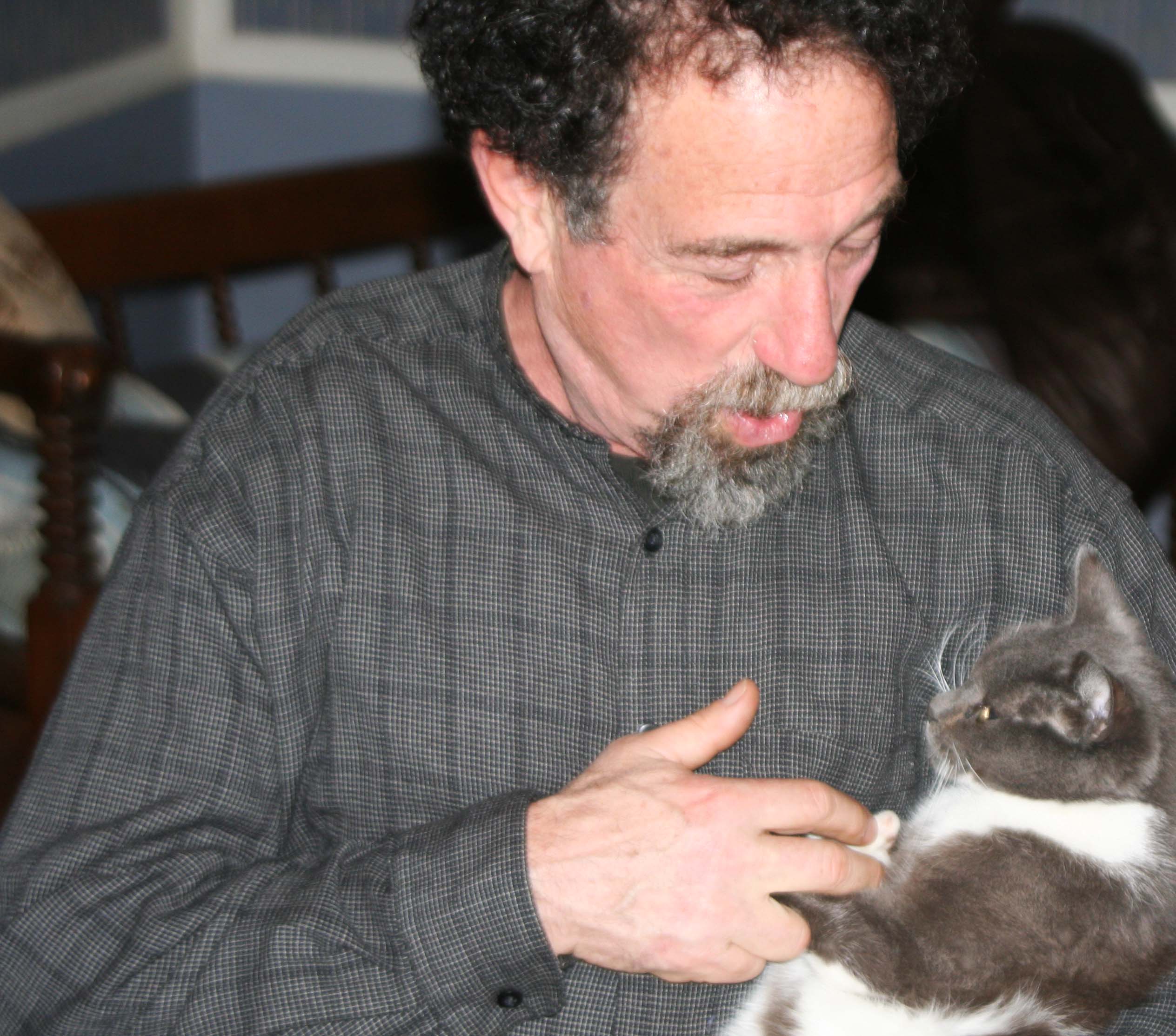
John Robbins has a discussion with his cat at his home in Sacramento, California.

John Kennedy created the Peace Corps in 1961 as one of his first acts as President of the United States. His reasons were both idealistic and pragmatic. Yes, he wanted to help third world countries combat the terrible poverty, disease, hunger, illiteracy and conflict they faced, but he was also interested in winning hearts and minds for the West. The mindset of Kennedy, and most other leaders of his generation, was that we were in the midst of a worldwide conflict between capitalism and communism, totalitarianism and democracy, and Christianity and Atheism. The Cold War was raging and much of this war was being fought in third world countries.

While few Peace Corps Volunteers would list “making friends for America” as their reason for joining the organization, it more or less comes with the territory of being from the United States and working intensely in another country to help people improve their lives. In this sense, the Peace Corps is one of the most effective foreign aid programs ever created by the US. It is certainly one of the least expensive– especially when the work Volunteers do overseas and the skills and commitment they bring back home are considered. A recent Peace Corps budget justification noted that the total cost of running the Peace Corps for the past 50 years could be covered with what the US spends on the military every six days.

My assignment was to serve as a teacher in Liberia, West Africa.  The country has a unique history dating back to the early 19th Century when freed slaves from America were shipped back to Africa. Within 30 years, the freed slaves, or Americo Liberians as they came to be known, had established themselves as the rulers of Africa’s first black republic. When I arrived in 1965, their descendants still controlled the political, military, justice, education and economic systems of Liberia– i.e. almost everything. William Shadrach Tubman, President of the country since 1944, had invited Peace Corps into Liberia to help tribal Liberians, who made up 95% of the population, prepare for a larger role in the nation’s future. Not all Americo-Liberians agreed with this goal– as I would learn.

“The Bush Devil Ate Sam” is a the story of adventures that I, along my ex-wife, Jo Ann, had in Africa, but it also includes, background on my decision to join the Peace Corps and some thoughts on the tragic history of Liberia since the 60s.

I begin with a brief look at the influence of my family’s restless nature and discover that I was right to be worried about the soldier knocking on our door: wandering can be hazardous to your health. William Mekemson has his head chopped of by tomahawks during the Blackhawk War and George Marshall, my mother’s great grandfather, is killed for his gold after striking it rich during California’s gold rush.

Following in the footsteps of my ancestors, I wander off to UC Berkeley where police occupy the campus, liberally use nightsticks, and drag students down stairs. A roommate tells the FBI I am a Red, a Communist– and I not even pink. But this is a time when innuendo is more important than facts and J. Edgar Hoover believes there is a Russian agent hiding behind every tree on campus. I figure my chances of making it into the Peace Corps are ruined. Sargent Shriver, the first director of the Peace Corps, likes people who challenge the status quo, however, and I soon find myself in the Sierra Nevada Mountains decapitating a chicken as part of my training.

In Liberia I am thrown into a second grade class of 7-22 year olds where children who barely speak English are taught reading out of aging California textbooks featuring middle-class white kids and Spot, a pet that resembles dinner. Peace Corps encourages me to write a Liberian second grade reader using Liberian children and African folk tales, which I do. Americo-Liberians in the Department of Education determine the book is subversive. It’s torpedoed and I am told to never mention the project.

The high school principal recruits me to teach social studies to 10th, 11th and 12th graders and Jo Ann to teach French and English. Somewhat to my surprise, I discover I enjoy teaching and may even be good at it. Things run smoothly until the Liberian government determines that the student government I create to teach my students about democracy is a direct challenge to the country’s one party state. I am told to pack my bags. My students are told they will be arrested.

Our tenth and eleventh grade classes and Jo Ann at Gboveh High School in Gbarnga, Liberia (1967)

Our tenth and eleventh grade classes and Jo Ann at Gboveh High School in Gbarnga, Liberia (1967)

On the home front I repulse an invasion of army ants, breed rhinoceros beetles, and watch Jo Ann make mincemeat out of a Green Mamba, one of the world’s more deadly snakes. A menagerie of animals adopt us and provide both companionship and comic relief. They also create mischief. Rasputin the Cat collaborates with the Cockle Doodle Rooster to wake us at five every morning. Do Your Part the Good Dog crashes a solemn ceremony I am at attending at a mosque and causes a riot while Boy the Bad Dog develops a penchant for eating guinea fowl that belong to the Superintendent (governor) of Bong County. It’s the latter that brings the soldiers to our house in the middle of the night. Apparently, the illegal consumption of would-be chickens is a more serious crime than writing a subversive second grade reader or teaching high school kids they can be part of the government.

Burning out a nest of army ants in Gbarnga, Liberia circa 1966.

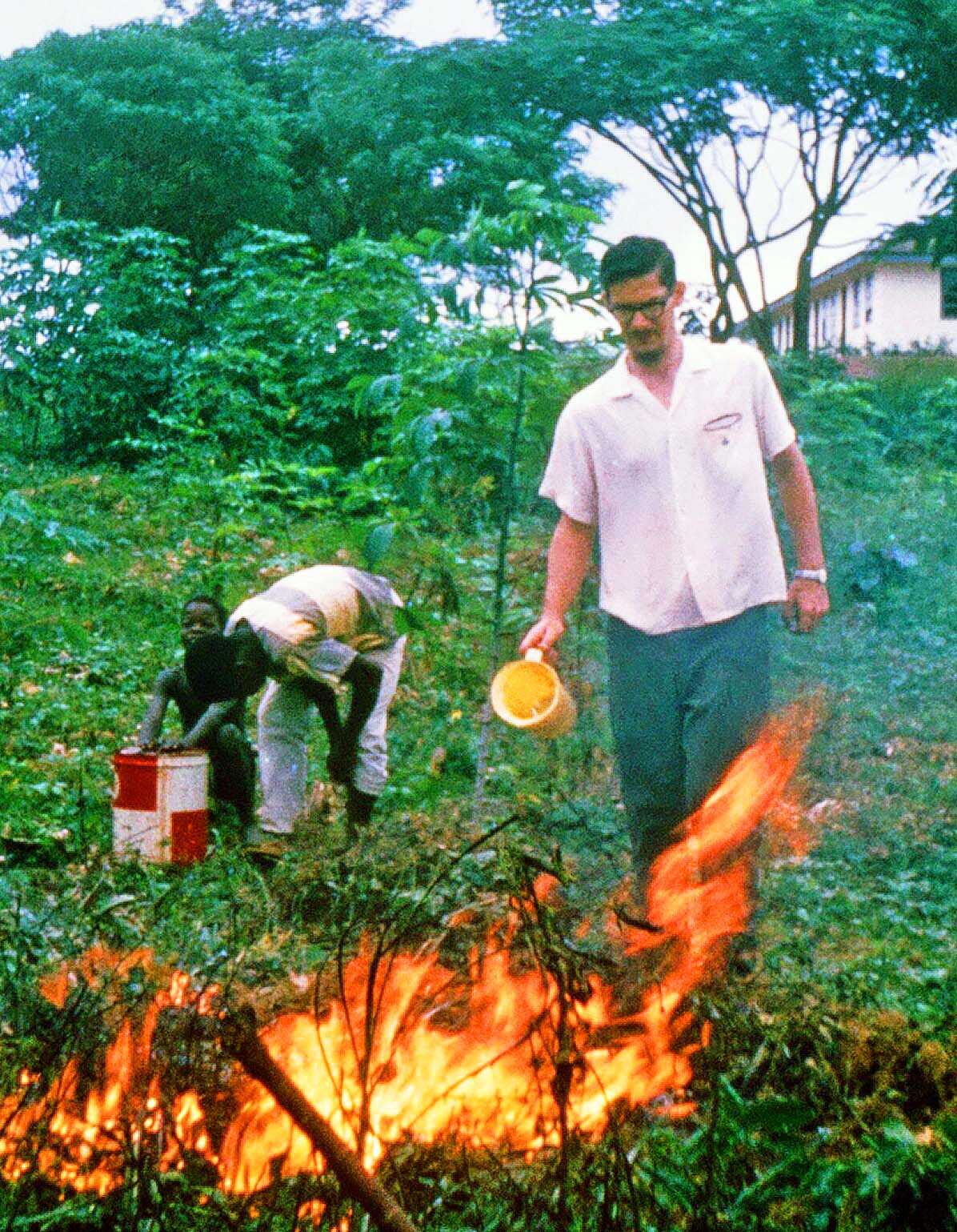
The army ants invaded our home. Here I burn out their nest in an effort to persuade them to move elsewhere.

I learn that the scarification marks marching up the chest on Sam, the young man who works for us, were ‘made’ by the Kpelle Bush Devil’s teeth, which leads to an interest in tribal culture. I discover the Lightning Man can make lightning strike people, sit in on a trial where justice is determined by a red-hot machete, and find myself involved in a situation where Juju, the dark magic of West Africa, is being used on one of my students.

The use of Juju in West Africa.

Mamadee Wattee, shown here, appeared at our house on a dark, stormy night to tell us that juju, dark magic, was being used to make him sick.

A year and a half into our service, we are numbered among the veteran Peace Volunteers of Liberia, the people to go to for sage advice. Jo and I take a month off to tour the big game parks of East Africa in a rented VW Bug, my students receive top national honors in social studies, and we turn down a request from Peace Corps’ to spend our last six months touring Liberia and training teachers. Instead we spend our time with the students who have earned our allegiance and the animals that have won our hearts.

I snapped this photo of a baby zebra with a Kodak Instamatic camera on our trip through East Africa.

I snapped this photo of a baby zebra with a Kodak Instamatic camera on our trip through East Africa.

One of my final encounters is disturbing. A representative from the US Embassy in Monrovia requests that I meet with him at our house in Gbarnga. He wants my views on the future of Liberia. My experience with the paranoid reactions of the government leads me to suggest that the future is bleak unless drastic changes are made in how Liberia is governed. Unfortunately, as I share in the Epilogue, much of what I feared in 1967 comes to pass. Only today is Liberia recovering from the tragic results.

12th Grade Class of Gboveh High School, Gbanrga, Liberia (1967)

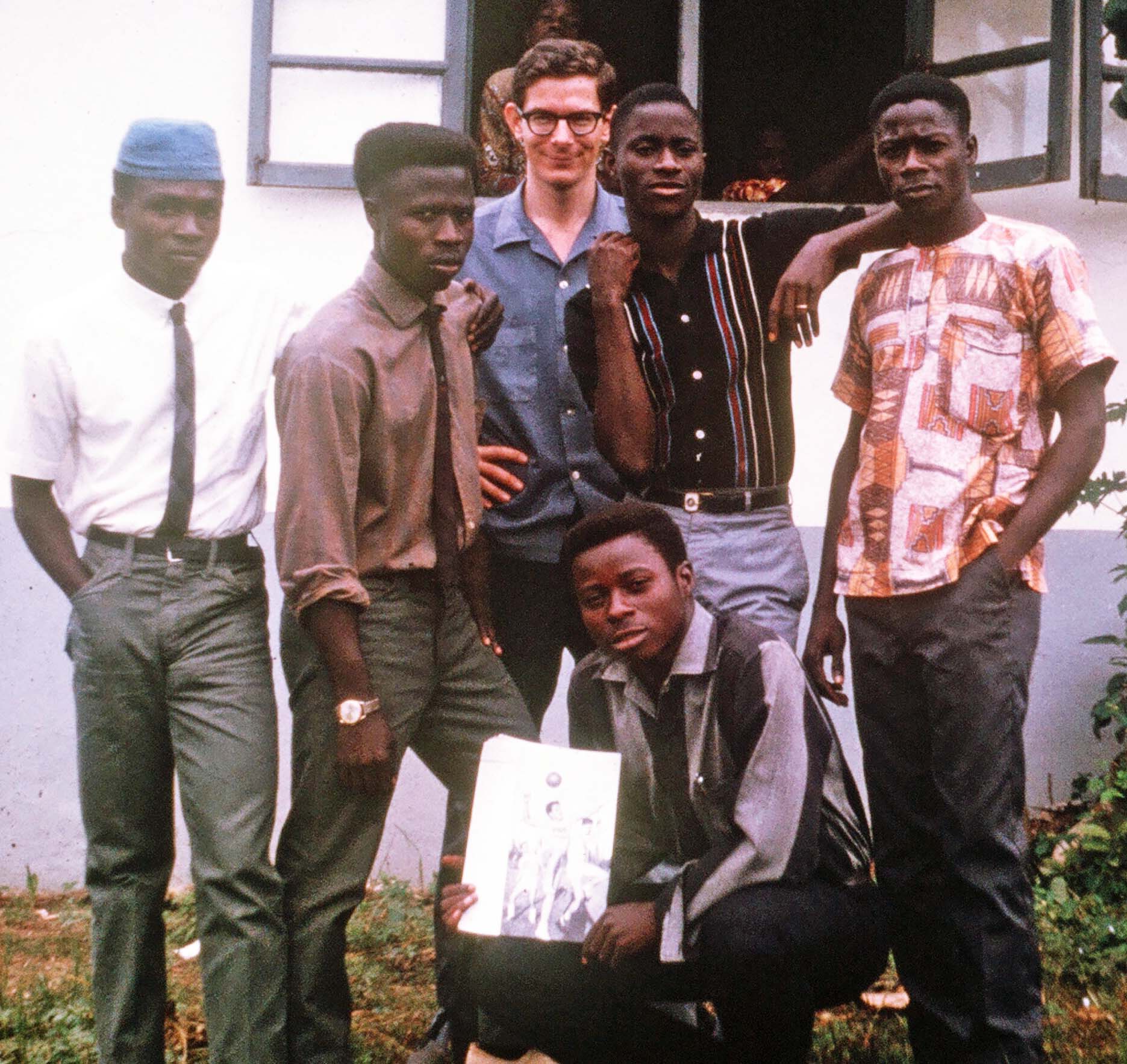
A photograph of my twelfth grade class along with me standing in front of Gboveh High School. (1967)

NEXT BLOG: I join the spirit of the season by re-blogging hair-raising stories of the ghosts that lived in the graveyard next to the house I grew up in.